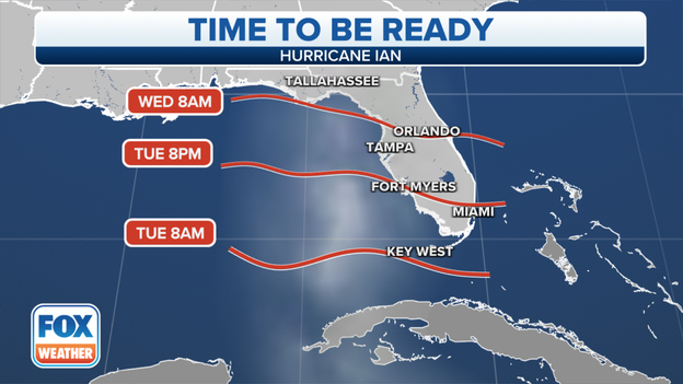
Florida braces for major Hurricane Ian as storm strengthens in Gulf of Mexico
Florida braces for major Hurricane Ian as storm strengthens in Gulf of Mexico
Download the AppContinuing live coverage of Hurricane Ian
View postCoverage for this event has ended.
Live coverage of Hurricane Ian for Tuesday, 09/27, has ended here. Live coverage of Hurricane Ian for Wednesday, 09/28 is now available by clicking here.
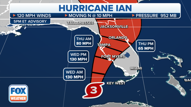
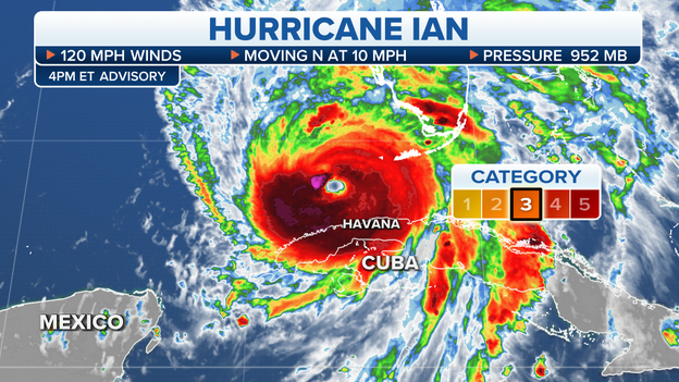
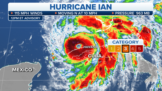
Hurricane Ian remains a dangerous Category 3 and is less than 170 miles from the Florida Peninsula.
Tracking Hurricane Ian
As of 11 p.m., Hurricane Ian was located over the Dry Tortugas or about 110 miles SW of Naples, Florida.
Maximum sustained winds remain around 120 mph, making the storm a dangerous Category 3.
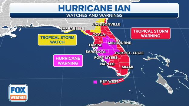
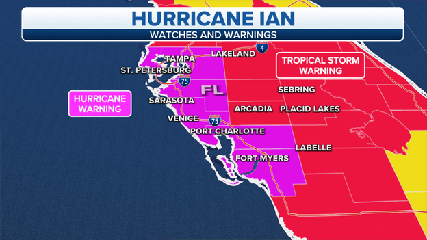
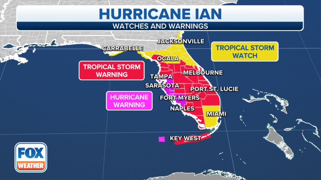
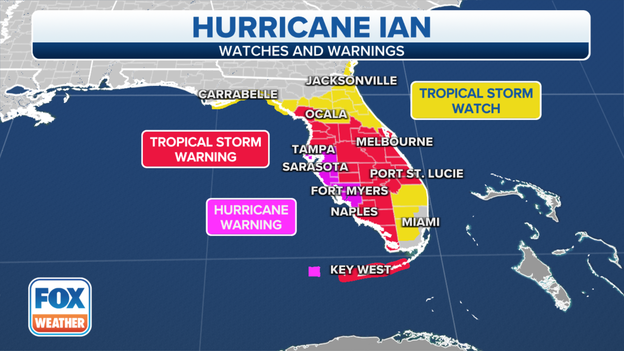
A Hurricane Warning continues for Florida's west coast and areas of the central Peninsula. This includes coastal locations such as Tampa Bay, Sarasota, Fort Myers, Cape Coral, Punta Gorda, Naples and Everglades City.
About 15 million people are covered by the Hurricane Warning.
A Tropical Storm Warning covers stretches from the Florida Keys into South Carolina, along the U.S. East Coast.
The hurricane is forecast to weaken slightly just before landfall on Wednesday evening.
Get the latest information about Hurricane Ian here.
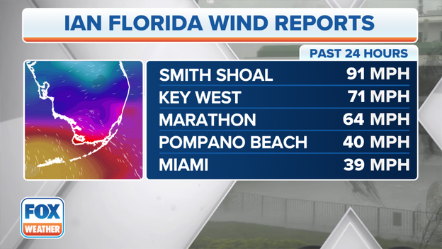
Fox Weather Wind Gust
Tropical-storm-force winds are impacting the Keys and South Florida. A 91 mph wind gust was reported about 11 miles northwest of Key West. Any sustained wind of at least 74 mph is considered to be hurricane-force.
You can track Hurricane Ian here.

Courtesy: Tom Pandas/TourHelicopter.com
Hurricane Ian has forced the issuance of dozens of Tornado Warnings in the Sunshine State and at least one of the tornadoes may have touched down in western Broward County.
Damage was reported to homes and several planes were flipped at the North Perry Airport in Hollywood, Florida.
So far, no injuries have been reported to the National Weather Service.
The northeast quadrant of a landfalling hurricane is often the region where most tornadoes form.
A Tornado Watch is in effect for South Florida through at least the early morning hours.
Read more on the damage: Click Here
Cuba's electric operators report the entire country is being impacted by a blackout. Operators report the problem is complex and at the earliest, it will be either tonight or tomorrow before restoration starts.
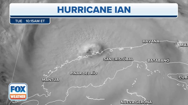
Hurricane Ian impacted the island with winds that were estimated to be at least 120 mph.
Hurricane Ian is less than 180 miles away from the Florida Peninsula. The storm's slow forward movement means the center will make landfall on Wednesday afternoon. Impacts will stretch outward hundreds of miles from the center.
You can track Hurricane Ian here.
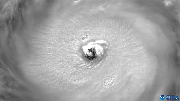
Hurricane Ian's eye
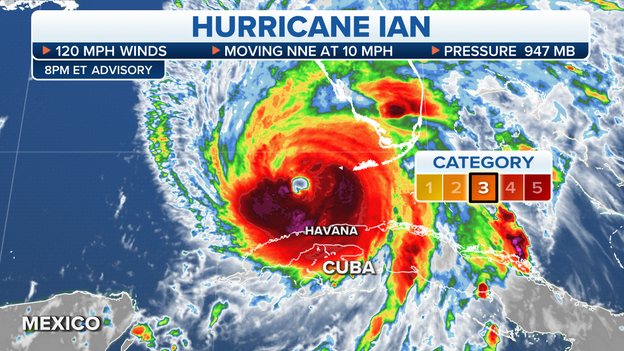
The latest advisory shows that Hurricane Ian's central pressure is 947 millibars.
With Ian reaching 947 mb, this makes it the lowest pressure for a September hurricane in the Gulf of Mexico since Hurricane Irma in 2017, Atlantic hurricane forecaster Phil Klotzbach says.
While it's important to focus on the wind speed, the lower the barometric pressure, the stronger the hurricane is.
Hurricane Irma's pressure dropped to 914 mb and had sustained winds of 185 mph.
Hurricane Facts
As of 8 p.m., Hurricane Ian was about 20 miles SSW of the Dry Tortugas or about 180 miles SSW of Punta Gorda, Florida.
Maximum sustained winds still remain around 120 mph but the FOX Forecast Center warns as long as the pressure continues to drop, there is a chance that winds could ramp up.
The last reported minimum pressure was around 947 millibars.
Recently Key West International Airport reported a sustained wind of 48 mph with a gust to 71 mph.
You can track Hurricane Ian here.
FOX Weather’s Robert Ray is in Fort Myers preparing for a significant storm surge.
"Tomorrow, where we are standing at some point, if the predictions keep modeling and trekking this way, will be underwater, potentially 8 to 10 feet maybe more of storm surge," Ray said. "There is nowhere here that vehicles are safe, there's not a second-floor or third-floor parking garage or anything like that. With that kind of surge, vehicles are going to be swept away and destroyed and lives will be in jeopardy.”
Find out whether your property is at threat from inundation: Click Here
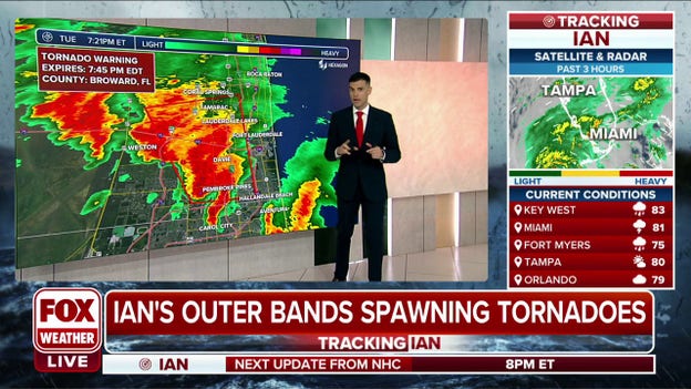
Tornado Warning for Davie FL, Plantation FL and Sunrise FL until 7:45 PM EDT
A Tornado Warning is in effect for Broward County, Florida, until 7:45 p.m.
The National Weather Service says the damaging tornado was spotted just before 7:25 p.m.
They warn that this is a life-threatening situation and residents should seek shelter immediately.
The Tampa metro region remains under a Hurricane Warning and conditions are continuing to deteriorate. A resident took video of boats swaying in the water ahead of the core of the hurricane.
The region could see a sizeable storm surge as Hurricane Ian piles water into waterways along the west coast of Florida: Read more

Disney Parks
Disney now says use of multi-day theme park tickets impacted by Hurricane Ian can happen on any date through September 30, 2023.
Disney will close theme parks on Wednesday and Thursday. Attractions that will close include: Magic Kingdom Park, EPCOT, Disney’s Animal Kingdom Theme Park, Disney’s Hollywood Studios, Disney’s Typhoon Lagoon water park, Winter Summerland Miniature Golf, Fantasia Gardens and Fairways Miniature Golf.
Additional park details: Click here
Tampa International Airport and other major Florida airports are closing as Hurricane Ian gets closer.
The last flight out of Tampa took off before 6 p.m. The airport is now closed to all passengers and visitors.
Hernando County areas along the coastline and low lying areas are under mandatory evacuation as Hurricane Ian's bands begin lashing the Gulf Coast.
Hernando County Administrator Jeff Rogers spoke to FOX Weather about final preparations before Ian makes landfall.
Weather alerts associated with Hurricane Ian. (FOX Weather)
Weather alerts associated with the approach of Hurricane Ian have been expanded Tuesday, meaning the majority of the Florida Peninsula will feel some type of impact from the storm.
A Hurricane Warning issued for Florida's west coast has been expanded farther south, and stretches from Chokoloskee to the Anclote River. This includes coastal locations such as Tampa Bay, Sarasota, Fort Myers, Cape Coral, Punta Gorda, Naples and Everglades City. The Dry Tortugas are also included.
The Hurricane Warning has also been expanded into the interior of the Florida Peninsula and includes the Orlando area.
About 7.4 million people are covered by the Hurricane Warning.
A Tropical Storm Warning now covers Florida's Atlantic coast, from as far north as Jacksonville to as far south as the Florida Keys. This includes coastal cities such as Miami, Ft. Lauderdale, West Palm Beach and Melbourne.
Inland parts of the Florida Peninsula are also covered by a Tropical Storm Warning.
In total, about 11.2 million people are covered by the watch.
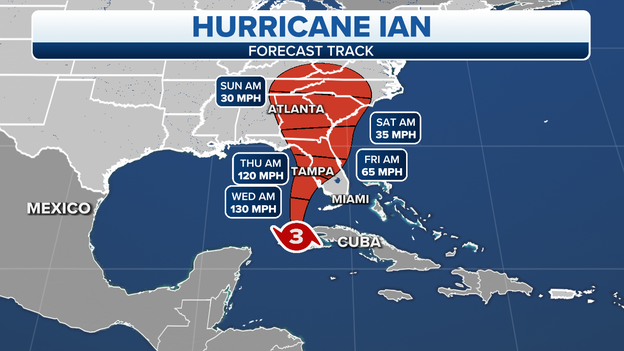
Hurricane Ian is currently a slow-moving Category 3 storm with 120 mph winds and a northward track at 10 mph. It is forecast to intensify to Category 4 strength with 130 mph winds late Tuesday or early Wednesday. It is forecast to weaken slightly just before landfall sometime late Wednesday or early Thursday.
You can track Hurricane Ian here.
Walt Disney World Resort theme parks and Disney Springs will close Wednesday and Thursday due to the latest forecast impacts of Hurricane Ian in Florida.
Magic Kingdom, Hollywood Studios, Animal Kingdom and EPCOT will close Wednesday, according to the Disney Parks blog.
Previously, Disney announced the Typhoon Lagoon water park will close Wednesday and Thursday. Disney’s Blizzard Beach water park is currently closed.
The last time Walt Disney World closed for a hurricane was Dorian in 2019.
The forecast cone for Hurricane Ian. (FOX Weather)
Hurricane Ian is maintaining its strength as a Category 3 storm with 120 mph.
The storm is located about 230 miles south of Sarasota, Florida, and is moving north at 10 mph.
The forecast calls for Ian to become a Category 4 hurricane with 130 mph winds by Tuesday night. From there, it is forecast to make landfall just south of Sarasota, Florida, by Wednesday night as a Category 3 storm with 125 mph winds.
Hurricane warnings have been extended farther south on the west coast of Florida to include locations as far south as Chokoloskee.
Tropical Storm Warnings have been issued for most of the Florida Peninsula outside of the state's west coast. This includes major cities such as Miami, Orlando and Jacksonville.
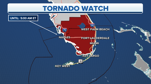
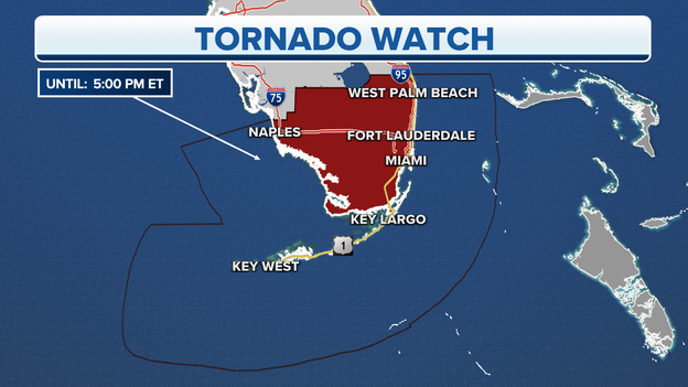
Tornado Watch issued for South Florida. (FOX Weather)
A Tornado Watch that was issued earlier for South Florida has been extended and expanded a bit farther north.
A Tornado Watch means that conditions in the area are favorable for the formation of tornadoes.
The new watch covers about 6.2 million people from near Vero Beach on the east coast to near Fort Myers on the west coast and south to Miami and the Florida Keys. It's in effect until 5 a.m. Wednesday.
Hurricane Ian is churning through the Gulf of Mexico toward Florida, providing sufficient lift and spin to create tornadoes, which is common with tropical systems near land. These tornadoes typically form with little warning and dissipate just as quickly.
Learn about five types of tornadoes here.
FOX Weather Hurricane Specialist Bryan Norcross will provide a live update after the National Hurricane Center issues the 5 p.m. advisory for Hurricane Ian. Watch live or view the recording in the video player.
NOAA's GOES 16 satellite's lightning mapper captured the massive size of Category 3 Ian and the lightning within the storm as the outer bands begin to lash Florida on Tuesday.
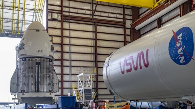
The Dragon Endurance spacecraft for NASA’s SpaceX Crew-5 mission arrives at the hangar at Kennedy Space Center’s Launch Complex 39A in Florida on Sept. 23, 2022. The capsule arrived at the launch complex after making the short journey from its nearby processing facility at Cape Canaveral Space Force Station. Photo credit: SpaceX
NASA and SpaceX are shifting the launch date of the next astronaut mission to the International Space Station due to Hurricane Ian. Initially scheduled for Monday, the space agency is now targeting no earlier than 12:23 p.m. EDT Tuesday, Oct. 4, for the Crew-5 launch from Kennedy Space Center.
"Mission teams will continue to monitor the impacts of Ian on the Space Coast and NASA’s Kennedy Space Center in Florida and could adjust the launch date again, as necessary," NASA wrote in a blog post.
The four-person astronaut crew is scheduled to arrive at KSC on Friday.
Current information about Hurricane Ian. (FOX Weather)
Hurricane Ian is continuing its slow movement north through the southeastern Gulf of Mexico toward Florida.
The Category 3 hurricane has winds of 120 mph and is about 250 miles south of Sarasota. It is moving north at 10 mph.
According to the National Hurricane Center, the meteorological agency of Cuba reported winds of 56 mph in Havana with gusts up to 87 mph in the past hour. The western tip of the island nation was pummeled by Ian earlier Tuesday.
Get the latest information about Hurricane Ian here.
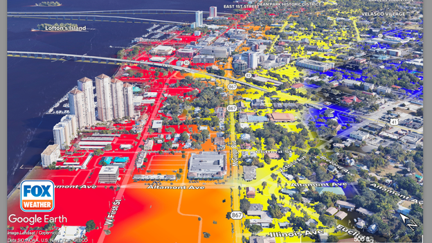
Hurricane Ian storm surge 3D model with Google Earth from the FOX Forecast Center.
The FOX Forecast Center is tracking worst-case scenario possible flooding in Fort Myers. These graphics show more than 9 feet of storm surge possible around the Fort Myers River District, according to the latest Hurricane Ian advisories.
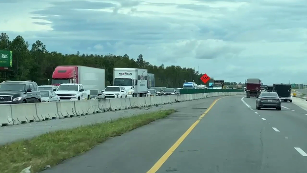
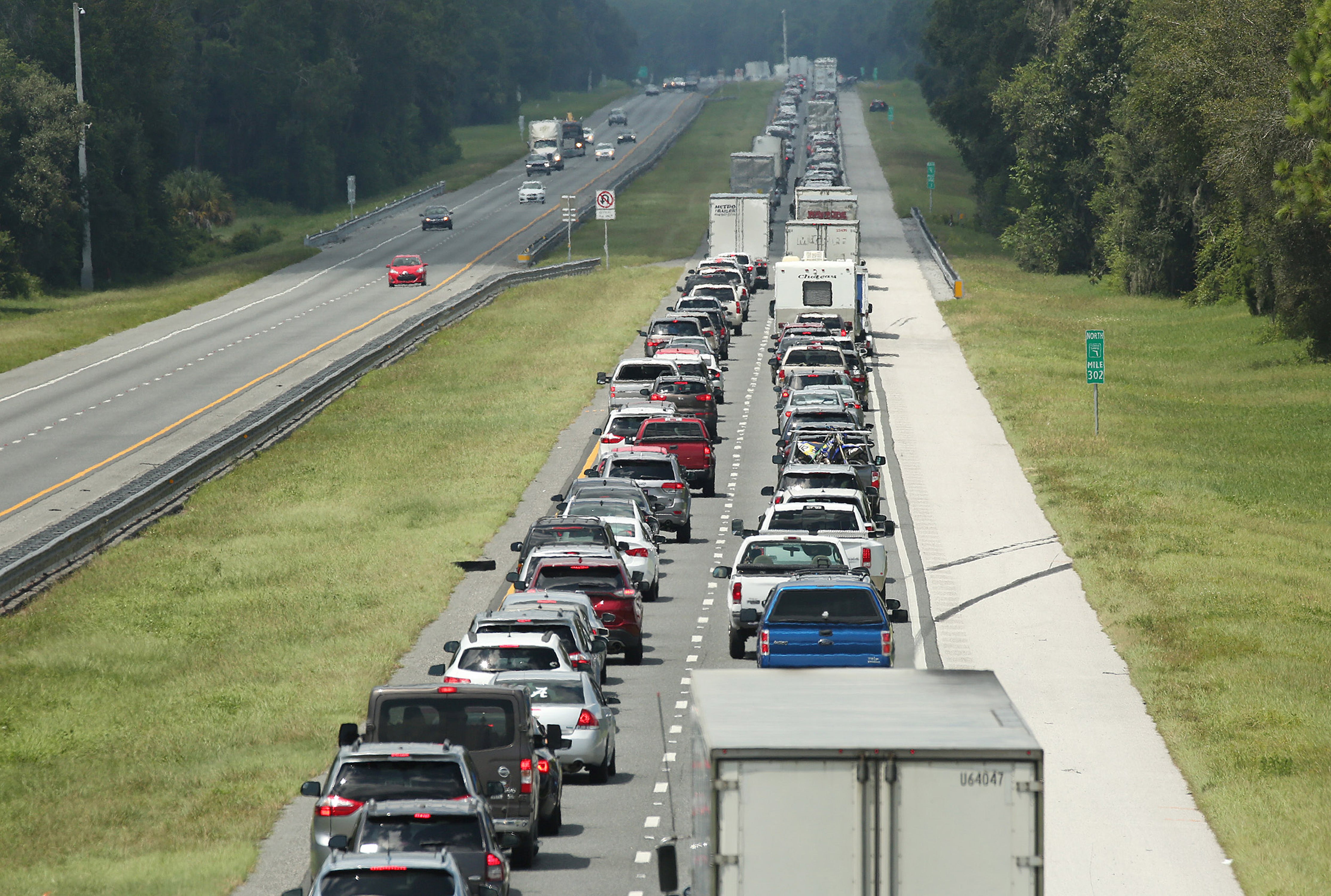
Interstate 4, between Tampa and Orlando, is seeing significant traffic as residents try to evacuate.
Florida Department of Transportation cameras show traffic is at a near stand still in some areas near Lakeland.
Weather alerts issued in Florida for Hurricane Ian. (FOX Weather)
A Hurricane Warning has been issued for a heavily populated section of the Florida Gulf Coast ahead of Hurricane Ian's arrival sometime late Wednesday or early Thursday.
About 4.6 million people from Tampa Bay to Fort Myers are under a Hurricane Warning, which means hurricane-force winds (74-plus mph) are expected to occur in the area soon. Preparations to life and property should be rushed to completion.
Even more people across Florida are under a Tropical Storm Warning, which covers about 9 million residents from as far north as Jacksonville to as far south as Key West. A Tropical Storm Warning means tropical storm conditions of strong winds and heavy rain are expected soon.
FOX Weather's Max Gorden spoke to Duke Energy spokesperson Ana Gibbs who said the company has trucks staged across Pinellas County to help restore power to their more than 500 million customers post-Ian.
However, storm conditions will need to calm considerably before crews get to work. They can not work in flooded areas and maximum winds need to be below 35 mph to use the bucket trucks.

The USF Bulls were scheduled to host East Carolina this Saturday at Raymond James Stadium in Tampa. According to USF Athletics, the game has been moved to Boca Raton. The Bulls and Pirates will play at FAU Stadium Saturday with kickoff set for 2:30 p.m.
In Gainesville, the University of Florida Gators rescheduled its Saturday game against Eastern Washington for Sunday. For a full list of changes to weekend games, click here.
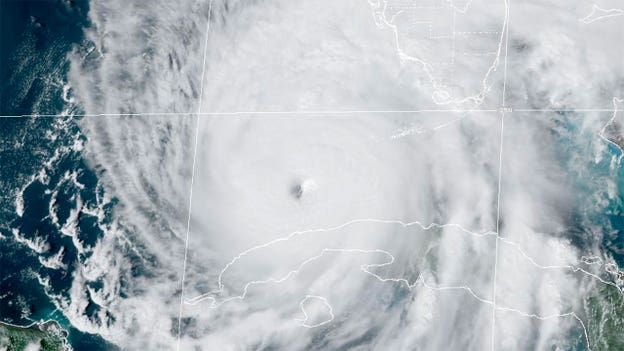
Hurricane Ian is seen in a satellite image taken Sept. 27, 2022. (NOAA)
Hurricane Ian is continuing to strengthen as it moves through the Gulf of Mexico en route to Florida.
While the winds remain steady at a powerful 120 mph, the central pressure of Ian has dropped to 952 millibars.
Central pressure is one of the measurements meteorologists use to determine the status of a hurricane. Lowering pressure translates to an intensifying storm, while increasing pressure means the opposite.
Ian is located about 255 miles south of Sarasota, Florida, and is moving north at 10 mph.

FOX Forecast Center 3D models show worse-case flooding in the Punta Gorda community.
The FOX Forecast Center is tracking worst-case scenario possible flooding on the Gulf Coast. These graphics using Google Earth show up to 9 feet of storm surge possible in Punta Gorda could submerge homes, businesses and schools. This flooding could impact 20,000 people.
Hillsborough County schools closed ahead of Hurricane Ian. Superintendent Addison Davis said just how long schools are closed depends on the impacts of the storm on schools, including some that are acting as shelters.

Graphic showing the worst case scenario given the latest Hurricane Ian track is up to 6 feet of water around the Tampa General campus.
The FOX Forecast Center is tracking worst-case scenario possible flooding in Tampa Bay. These graphics show up to 6 feet of storm surge possible around the Tampa General Hospital campus.
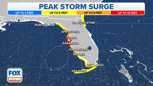
Peak storm surge forecast for Hurricane Ian. (FOX Weather)
The latest forecast shows up to 9 feet of storm surge is possible in Tampa Bay because of Hurricane Ian.
Storm surge is the rise of water levels caused directly by a storm and does not take into account rainfall or wave size, which can add additional feet on top of a storm’s surge.
The highest storm surge is forecast to affect areas from Longboat Key south to Bonita Beach. This includes coastal cities such as Sarasota, Cape Coral and Fort Myers. That is where up to 12 feet of storm surge is possible.
Forecasters said these are the heights that are possible if peak storm surge coincides with high tide.
Read more here about the storm surge risk along Florida's Gulf Coast.

NASA’s Space Launch System (SLS) rocket with the Orion spacecraft aboard is seen atop the mobile launcher as it returns to the Vehicle Assembly Building from Launch Pad 39B, Tuesday, Sept. 27, 2022, at NASA’s Kennedy Space Center in Florida. Photo Credit: (NASA/Joel Kowsky)
After rolling back the SLS rocket into the hangar, NASA's Kennedy Space Center continues taking steps to prepare for Ian. KSC Director Janet Petro said the center's hurricane plan applies to all of NASA and contractors.
Currently at HURCON III, a HURCON II status expected Wednesday or later today, which would send home all non essential personnel.
Petro said next steps for Crew-5, a planned astronaut launch on Oct. 3, will be determine by any potential damage to KSC from Ian.
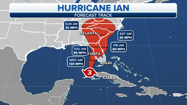
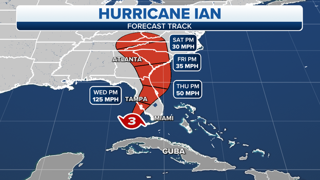
Forecast track of Hurricane Ian. (FOX Weather)
After briefly weakening while crossing Cuba overnight, Hurricane Ian has started its strengthening after entering the Gulf of Mexico on Tuesday morning.
As of 2 p.m. EDT, Ian has winds of 120 mph. This makes the storm a Category 3 hurricane on the Saffir-Simpson Scale.
Ian is located about 265 miles south of Sarasota, Florida. The speed of movement has remained the same as the last advisory -- still north at 10 mph.
There have been no changes to watches and warnings.
Sarasota Mayor Eric Arroyo said his community has been preparing for Hurricane Ian since last week. The Florida Gulf Coast city is under a Hurricane Warning.
“We’ve done and we are doing the most we can do," Arroyo said. “We just ask that our residents take this seriously and they be proactive and don’t wait until the last minute.”
Kentucky Gov. Andy Beshear has authorized the National Guard to assist Florida as it deals with the major impacts of Hurricane Ian.
Florida sent help to Kentucky in the aftermath of major flooding there in July.
"We will be there for them during the hurricane," Beshear said.
Video recorded by Nick Underwood with NOAA shows the view from inside NOAA's Hurricane Hunter plane "Kermit" as the team flies into the eye of Hurricane Ian gathering more data on the Category 3 storm.
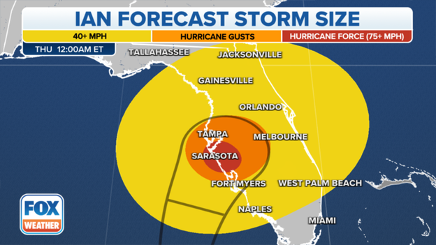
Tropical-storm-force winds will extend well beyond Ian's forecast cone.
Hurricane Ian is growing in size, and therefore, its wind, rain and storm-surge impacts will extend beyond the forecast cone, which only tracks the center of the storm.
Hurricane-force winds (74-plus mph) currently extend outward up to 35 miles from Ian's center, and tropical-storm-force winds (39-plus mph) extend outward up to 140 miles.
This places much of the Florida Peninsula and Big Bend region at risk of at least tropical-storm-force winds, particularly in gusts that will likely top 40 mph.
The increased winds are expected to arrive from south to north in the Florida Peninsula beginning late Tuesday.
Satellite images show powerful Hurricane Ian spinning off the coast of Cuba
Check out this incredible video of Hurricane Ian spinning off the coast of Cuba after making landfall early Tuesday morning.
Hurricane Ian weakened slightly while it was over land, but it's expected to strengthen once again as it spins into the Gulf of Mexico and closer to Florida.
1 p.m. Eastern status of Hurricane Ian.
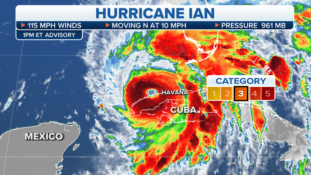
The National Hurricane Center said Hurricane Ian was about 100 miles south-southwest of Florida's Dry Tortugas and 280 miles south-southwest of Sarasota, Florida, as of 1 p.m. Eastern.
Ian remained a Category 3 hurricane with maximum sustained winds of 115 mph as it moved northward at about 10 mph.
Any hurricane that is rated Category 3, 4 or 5 on the Saffir-Simpson Hurricane Wind Scale is classified as a major hurricane.
Ian is forecast to reach Category 4 intensity by Tuesday night over the southeastern Gulf of Mexico.
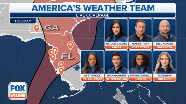
America's Weather Team has been positioned across Florida to cover the effects of Hurricane Ian.
America’s Weather Team has been positioned across Florida as the Sunshine State prepares for major impacts from Hurricane Ian.
From Tallahassee to Orlando and the Tampa Bay area to Fort Myers and Naples – FOX Weather will keep you informed before, during and after Hurricane Ian batters the state.
Check out a live look at the Florida Keys as Hurricane Ian approaches the area.
Hurricane Ian is expected to strengthen into a Category 4 storm as it barrels towards Florida.
In a move that will have a major ripple effect across the country, Orlando International Airport announced it will cease operations at 10:30 a.m. Wednesday due to Hurricane Ian.
It's currently unknown when operations will resume at MCO.
Travelers need to contact their airlines directly for any updates in regard to specific flights.
Here’s more on how Hurricane Ian is disrupting air travel nationwide.
The passenger terminal at Orlando Sanford International Airport will be closing at 5 p.m. ahead of Hurricane Ian.
Because of the closure, all flights have been canceled on Wednesday and Thursday.
Here’s how Hurricane Ian will have a major effect on air travel.
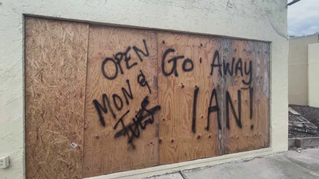
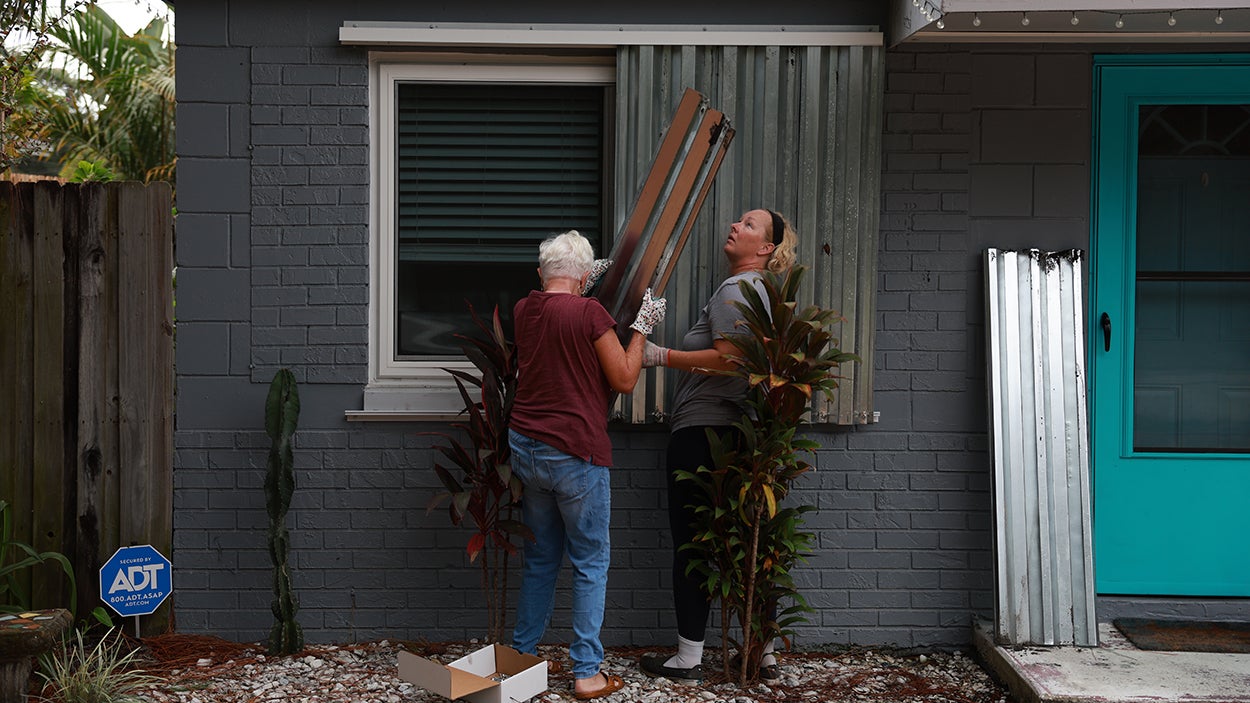
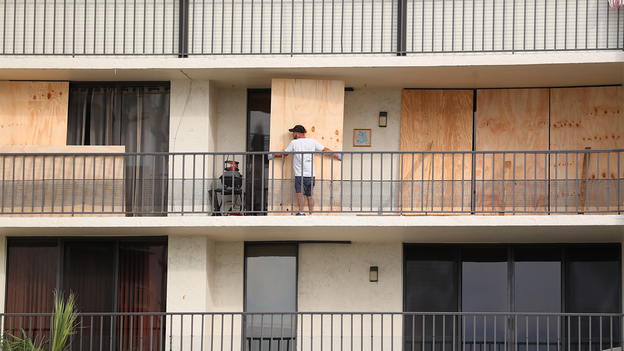
A boarded up window shows the message "Go away, Ian" in Tampa.
This video shows how Tampa Bay residents have been busy boarding up doors and windows ahead of Hurricane Ian as the monster hurricane is expected to bring torrential rain, strong wind and life-threatening storm surge.
In addition, residents along the coast and in low-lying areas have been told to evacuate inland or to a shelter.

Peak storm surge forecast for Hurricane Ian.
According to the National Hurricane Center, the water could reach the following heights above ground somewhere in the indicated areas if the peak storm-surge inundation occurs at the time of high tide:
-Middle of Longboat Key to Bonita Beach, including Charlotte Harbor: 8-12 feet
-Bonita Beach to Chokoloskee: 5-8 feet
-Anclote River to the middle of Longboat Key, including Tampa Bay: 5-8 feet
-Suwannee River to Anclote River: 4-6 feet
-Mouth of the St. Mary's River to Altamaha Sound: 4-6 feet
-Chokoloskee to East Cape Sable: 4-6 feet
-Dry Tortugas: 3-5 feet
-Marineland to the mouth of the St. Mary's River, including the St. Johns River: 3-5 feet
-Altamaha Sound to the Savannah River: 3-5 feet
-St. Johns River south of Julington: 2-4 feet
-Savannah River to the South Santee River: 2-4 feet
-Flagler/Volusia County line to Marineland: 2-4 feet
-East Cape Sable to the Card Sound Bridge: 2-4 feet
-Aucilla River to the Suwannee River: 2-4 feet
-Patrick Air Force Base to the Flagler/Volusia County line: 1-3 feet
-Indian Pass to the Aucilla River: 1-3 feet
The deepest water will occur along the immediate coast near and to the right of where Hurricane Ian makes landfall, where the storm surge will be accompanied by large waves. Surge-related flooding depends on the relative timing of the surge and the tidal cycle and can vary greatly over short distances.
Click here to learn why Florida’s Gulf Coast is extremely susceptible to a hurricane’s storm surge.
For the safety of their guests, LEGOLAND Florida has announced it will close the theme park on Wednesday and Thursday because of Hurricane Ian.
Florida residents have spent the last several days preparing for Hurricane Ian, including filling sand bags and buying food and water.
Traffic is seen on Interstate 4 about 40 miles east of Tampa.
People are listening to evacuation orders and are leaving the coast and other low-lying areas ahead of Hurricane Ian.
Check out this video taken by FOX Weather correspondent Robert Ray shows gridlock on I-4 about 40 miles outside of Tampa.
12 p.m. Eastern status of Hurricane Ian.
Because the eye of Hurricane Ian is now visible on the Key West Doppler radar, the National Hurricane Center will issue hourly updates on the status and position of Ian.
As of 12 p.m. Eastern, Hurricane Ian remained a Category 3 hurricane and was centered about 110 miles south-southwest of the Dry Tortugas and 285 miles south-southwest of Sarasota, Florda.
People in Flagler County that live east of I-95, as well as low-lying areas and mobile homes, to prepare to evacuate ahead of Hurricane Ian.
Hundreds of thousands of Florida residents have been told to evacuate the coast and low-lying areas as the powerful hurricane spins closer to the state.
A life-threatening storm surge is also expected as the storm advances.
Florida's largest grocer is preparing for Hurricane Ian by closing hundreds of stores on Tuesday evening in the Tampa Bay and Gulf Coast area.
Publix store closures are planned from the West Coast, inland to I-75 and as far north as Lake County in Central Florida. The grocer plans to reopen most locations on Friday.
For the full list of store hours and a map, click here.
Tampa Electric says they are prepared to respond to severe weather expected to affect Florida in the coming days due to Hurricane Ian.
The electric company, which serves more than 800,000 customers in West Central Florida, said they might interrupt service to a small portion of evacuated Zone A in downtown Tampa in an effort to help reduce restoration time.
The proactive shutdown could happen as early as Wednesday.
Video shows Hurricane Ian hitting Pinar Del Rio, Cuba, on Tuesday causing roofs to blow off some buildings.
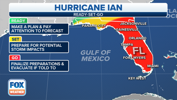
Evacuation preparedness levels across Florida as Hurricane Ian approaches.
By this point, most of the Florida Peninsula should be prepared to evacuate if placed under mandatory evacuation orders. The Panhandle and southern Georgia should prepare for potential storm impacts from Hurricane Ian. Find the latest evacuation orders and zones here.
A map showing the active watches and warnings in effect along the path of Hurricane Ian.
Hurricane, Tropical Storm and Storm Surge Watches and Warnings have been expanded northward and now include portions of Georgia and South Carolina in addition to Florida. Here's a summary of the watches and warnings currently posted in the Southeast:
Hurricane Warnings have been issued for:
-Bonita Beach to the Anclote River in Florida, including Tampa Bay
-Dry Tortugas in Florida
Storm Surge Warnings have been issued for:
-Suwanee River southward to Flamingo in Florida
-Tampa Bay
-Dry Tortugas in Florida
-Marineland, Florida, to the mouth of the St. Mary's River at the Florida-Georgia border
-St. Johns River in Florida
Tropical Storm Warnings have been issued for:
-Suwannee River to the Anclote River in Florida
-Flamingo to Bonita Beach in Florida
-Lower and middle Florida Keys
-Boca Raton, Florida, to Altamaha Sound, Georgia
-Lake Okeechobee in Florida
Storm Surge Watches have been issued for:
-Florida Keys from the Card Sound Bridge westward to Key West
-Florida Bay
-Aucilla River to Suwanee River in Florida
-Mouth of the St. Mary's River at the Florida-Georgia border to the South Santee River in Georgia
-South of Marineland, Florida, to the Volusia/Flagler County line in Florida
Hurricane Watches have been issued for:
-North of the Anclote River to the Suwannee River in Florida
-South of Bonita Beach to Chokoloskee in Florida
Tropical Storm Watches have been issued for:
-North of the Suwannee River to Indian Pass in Florida
-North of Altamaha Sound to the South Santee River in Georgia
-South of Boca Raton to east of Flamingo in Florida
-Upper Florida Keys
-Florida Bay
Here's what you should do if Hurricane or Tropical Storm Watches and Warnings have been issued for your town.
FOX Weather Hurricane Specialist Bryan Norcross breaks down the newest Hurricane Ian advisory from the National Hurricane Center.
Uber announced it will offer free round-trip rides to and from a state-approved shelter.
Residents up and down Florida's Gulf Coast have been told to evacuate the area as Hurricane Ian approaches.
Zone A, Zone B and Zone C are under mandatory evacuation orders.
This includes areas west of US 19.
Here’s more information on evacuations if you don’t “know your zone.”
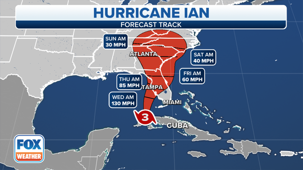
The projected path and intensity of Hurricane Ian.
Hurricane Ian has weakened slightly and now has maximum sustained winds of 115 mph, but it remains a Category 3 major hurricane on the Saffir-Simpson Hurricane Wind Scale.
The FOX Forecast Center expects Hurricane Ian to restrengthen from later Tuesday through Wednesday as it moves over the warm waters of the southeastern Gulf of Mexico.
Ian is forecast to approach the Tampa Bay area along the Gulf Coast of Florida as an extremely dangerous major hurricane on Wednesday night and Thursday morning. High winds and a life-threatening storm surge are expected.
Due to the threat of Hurricane Ian, Southwest Airlines has announced it has canceled all flights at Southwest Florida International Airport in Fort Myers, Florida, on Wednesday.
Here's how air travel will be disrupted because of the hurricane.
Charlotte County Communications Manager Brian Gleason talks with FOX Weather meteorologist Britta Merwin about how the county is bracing for the impacts from Hurricane Ian.
Lee County opened general population shelters at 9 a.m. Tuesday.
Other shelters have been opened as Hurricane Ian moves closer to the area.
Here's where you can find the latest shelter information.
Artemis 1 managers announced Monday plans to roll back the SLS to the VAB due to the latest Hurricane Ian forecast, which includes Florida's Space Coast in the cone of uncertainty.
The first motion of the crawler used to move the giant rocket happened at 11 p.m. ET Monday and the SLS was back inside the VAB well ahead of Hurricane Ian by Tuesday morning.
Rear Adm. Jim Aiken, commander of U.S. Naval Forces Southern Command, said U.S. 4th Fleet ships will depart from Mayport Naval Air Station in Jacksonville on Tuesday.
And an evacuation order was issued for non-mission essential individuals at MacDill Air Force Base in Tampa, Florida, according to the base.
Mandatory evacuations have been announced for Zone A, Zone B and Zone C in Pinellas County, Florida.
Hurricane Ian is expected to bring heavy rain, strong wind, and life-threatening storm surge to Florida’s Gulf Coast as the storm moves closer.
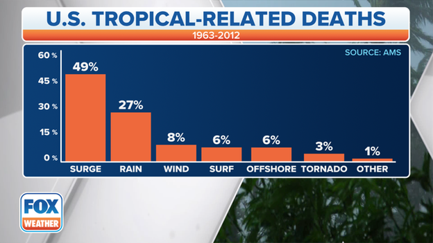
Cause of death in the U.S. directly attributable to Atlantic tropical cyclones between 1963-2012. (Data: Edward N. Rappaport, National Hurricane Center)
Hurricane Ian will pose a life-threatening storm surge threat in Florida, including Tampa Bay, where 5- to 10-feet of inundation is predicted by the National Hurricane Center.
Although hurricanes may only be rated by their sustained wind on the Saffir-Simpson Hurricane Wind Scale, it’s important not to overlook the power of water when a tropical cyclone is bearing down on the U.S.
Water is the No. 1 killer during a hurricane or tropical storm that strikes the U.S. – comprising nearly 90% of all tropical cyclone deaths – mostly by drowning in either storm surge, rainfall flooding or high surf, according to a 2014 study by Dr. Edward Rappaport, deputy director of the National Hurricane Center.
During Rappaport’s 1963-2012 period of study, storm-surge flooding claimed nearly half of the fatalities (49%), rainfall-induced freshwater floods and mudslides accounted for about one-quarter of the deaths (27%), high surf was responsible for some 6% of all hurricane deaths and another 6% occurred offshore in marine incidents within 50 nautical miles of the coast.
Click here to read more about the power of water during hurricanes and tropical storms.

Time is running out for Floridians as major Hurricane Ian moves closer to the state.
According to the Federal Emergency Management Agency, you should include a supply of food and water that can last for several days in your emergency kit, as well as flashlights, batteries and first aid kits.
Here are other ways you can prepare.
The Manatee County Sheriff announced mandatory evacuations for Zone A and Zone B and a voluntary evacuation for people in Zone C.
Bridges will also be closed at Snead Island, Manatee Avenue and Cortez Road to traffic entering Sneed Island and Anna Maria Island starting at 8 p.m. Tuesday.
Here's how you can "know your zone" when evacuations are issued.
FOX Weather correspondent Max Gorden is in Pinellas Park where residents have packed a local Home Depot to stock up on plywood to board up homes and prepare for the storm.
Evacuations have been ordered for millions of people along Florida's Gulf Coast as Hurricane Ian approaches the state.
Allstate Catastrophe Team Member April Eaton speaks with FOX Weather meteorologist Jason Frazer about what Floridians can do to make sure they’re properly insured as Hurricane Ian approaches.
Spirit Airlines announced on Monday that a travel advisory has been issued.
Passengers are being warned that flights will likely be affected and anyone expected to take a flight should contact the airline for the latest.
Here's more information on how Hurricane Ian is affecting travel.
At a news conference Tuesday morning, Florida Gov. Ron DeSantis said a website has been set up for the latest information on shelters for those who have been told to evacuate the coast and low-lying areas as Hurricane Ian approaches.
Here's where you can find the latest shelter information.
The predicted peak storm surge from Hurricane Ian in Florida.
The large size of Hurricane Ian, in combination with its potential to slow down in forward progress as it approaches Florida's Gulf Coast, will increase the threat of life-threatening storm surge, regardless of the hurricane's intensity at landfall.
According to the National Hurricane Center, the water could reach the following heights above ground somewhere in the indicated areas if the peak surge occurs at the time of high tide:
-Anclote River to Bonita Beach, Florida, including Tampa Bay and Charlotte Harbor: 5 to 10 feet
-Suwannee River to Anclote River: 5 to 8 feet
-Bonita Beach, Florida, to Chokoloskee, Florida: 4 to 7 feet
-Chokoloskee, Florida, to East Cape Sable, Florida: 3 to 5 feet
-Flagler/Volusia County line in Florida to Altamaha Sound in Georgia, including the St. Johns River in Florida: 2 to 4 feet
-East Cape Sable, Florida, to Card Sound Bridge, Florida, including Florida Bay: 2 to 4 feet
-Aucilla River to Suwannee River in Florida: 2 to 4 feet
-Florida Keys, including the Dry Tortugas: 2 to 4 feet
-Indian Pass, Florida, to Aucilla River, Florida: 1 to 3 feet
Storm-surge flooding might begin as soon as late Tuesday in far South Florida, then along the rest of Florida's Gulf Coast by Wednesday.
The peak surge is expected to occur near and south of where Hurricane Ian makes landfall on the Gulf Coast of Florida.
Click here to learn why Florida’s Gulf Coast is extremely susceptible to a hurricane’s storm surge.
Florida Governor Ron DeSantis is holding a new conference with new information on how the state is preparing for the major effects of Hurricane Ian.
Hurricane Ian is expected to bring torrential rain, strong winds, live-threatening storm surge and flooding.
A Tornado Watch is in effect for parts of South Florida until 5 p.m.
The National Weather Service issued a Tornado Watch for parts of South Florida until 5 p.m.
The Tornado Watch was issued as Hurricane Ian advances into the Gulf of Mexico on a path that will take it to Florida as a major hurricane.
Here’s how you can prepare for a tornado.
FOX Weather Hurricane Specialist Bryan Norcross explains how Hurricane Ian is already affecting Florida and what the state can expect as the monster hurricane barrels towards the Sunshine State.
Tampa International Airport is suspending all operations at 5 p.m. on Tuesday due to Hurricane Ian.
Passengers are urged to check with their airline for the latest flight status updates.
As Hurricane Ian approaches the western coast of Florida, many travelers with plans to fly to the Sunshine State are trying to navigate potential airline cancelations and delays to the storm.
Here’s how Hurricane Ian is affecting air travel.
Cape Coral City Manager Rob Hernandez declared a State of Local Emergency at 7 a.m. for all of Cape Coral due to Hurricane Ian.
In addition, Lee County has issued mandatory evacuations for Zone A and Zone B.
In it's 8 a.m. advisory, the National Hurricane Center said Hurricane Ian has maintained its Category 3 strength and winds are still at 125 mph.

Images show an empty MacDill Air Force Base ahead of Hurricane Ian
MacDill Air Force Base sits at the bottom of the Tampa peninsula.
It's home to two key military headquarters: Central Command (overseeing the Middle East) and Special Operations command.
That's in addition to the air-to-air refueling wing.
Photos show that those planes are now gone and the base will likely be flooded when Hurricane Ian approaches the area.
The projected path and intensity of Hurricane Ian.
If Hurricane Ian follows a track near the center of the forecast cone, it would be nearly a worst-case scenario for the Tampa Bay area because the powerful winds in Ian's eyewall would plow through the cities of Tampa, St. Petersburg and Clearwater. This track would also push life-threatening storm surge directly into Tampa Bay.
The National Hurricane Center is forecasting a 5- to 10-foot storm surge for Tampa Bay. Storm-surge flooding could begin along Florida's Gulf Coast as soon as Wednesday. The peak surge is expected to occur near and south of where Hurricane Ian makes landfall.
Photos show NASA rolling the Artemis 1 rocket back to the Vehicle Assembly Building in preparation for Hurricane Ian.
On Saturday morning, NASA teams decided to stand down on preparing for a Tuesday launch opportunity to allow them time to configure systems for rolling back the SLS rocket and Orion spacecraft to the Vehicle Assembly Building.
Artemis 1 managers announced Monday plans to roll back the SLS to the VAB due to the latest Hurricane Ian forecast
Hurricane Ian is expected to hit Florida’s Gulf Coast, but the major hurricane’s effects will be felt statewide.
Acting deputy director of the National Hurricane Center Michael Brennan joined FOX Weather meteorologist Britta Merwin to discuss the latest with Hurricane Ian including the likelihood of widespread power outages, life-threatening storm surge and where the Category 3 hurricane is headed next.
An image showing when preparations should be completed ahead of Hurricane Ian.
Florida residents are running out of time when it comes to completing hurricane preparations.
Floridians have spent the last several days preparing for Hurricane Ian by stocking up on food, water and other supplies, as well as filling sandbags in preparation for flooding.
Here's what you should include in your emergency kit.
Watch as NOAA’s Hurricane Hunters fly into Hurricane Ian to gather important, life-saving information.
Hurricane Hunters are part of the Aircraft Reconnaissance of the National Hurricane Center, a division within NOAA.
They fly through storms to gather valuable data first-hand for NHC meteorologists, so they can fine-tune their forecasts.
Sandbag locations will close at 2 p.m. in Hillsborough County because of Hurricane Ian's approach.
Florida residents have spent the past several days filling sandbags and stocking up on food, water and other supplies ahead of the powerful hurricane.
FOX Weather meteorologist Jason Frazer explains how Hurricane Ian's impacts will affect the entire state of Florida.
Torrential rain, strong winds and a life-threatening storm surge are expected as Hurricane Ian moves closer to the state.
The National Weather Service issued a Tornado Warning for Tavernier and Plantation Key, Florida, until 7:15 a.m.
If you don't have a storm shelter, get into a basement or interior room of a structure and stay away from doors and windows.
Here are other tornado safety tips.
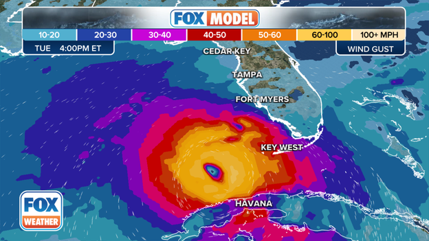
FOX Model shows potential Hurricane Ian wind gusts on Tuesday evening.
The exclusive FOX Model seen only on FOX Weather shows the potential wind gusts from Hurricane Ian on Tuesday evening.
Hurricane Ian is expected to strengthen into a Category 4 storm as it approaches Florida today.
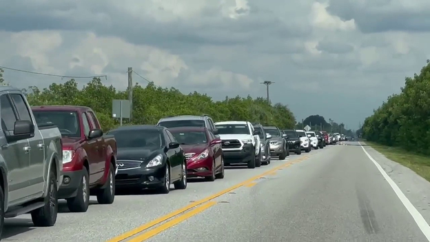
A line of cars is seen leaving
A line of cars is seen on video leaving Apollo Beach, Florida, as evacuation orders are issued for people living along Florida’s Gulf Coast.
People who have been told to leave are being asked to only use shelters as a last resort.
Instead, people should ask friends, family or co-workers who live at least 20 miles inland for a place to stay.
Video shows empty shelves at a Publix in downtown Tampa as residents prepare for Hurricane Ian.
You should stock up on other supplies when preparing for a hurricane.
Here's what should be included in your hurricane preparedness kit .
The Florida Department of Emergency Management made an interactive map for residents and visitors to type in an address to see if their location is included in an evacuation zone.
It will also show the quickest exit route to safety.
Hurricane Ian is expected to strengthen into a Category 4 hurricane as the monster storm takes aim at Florida.
Florida Gov. Ron DeSantis said at least 24 counties in Florida have canceled school as Hurricane Ian approaches, and more are expected as the monster Category 3 hurricane moves closer to the Sunshine State.
Schools will be used as shelters for many of the hundreds of thousands of people who have been told to evacuate the coast and other low-lying areas.
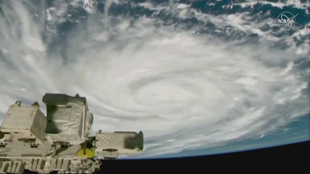
Hurricane Ian is seen from the International Space Station
Astronauts were able to record incredible video of Hurricane Ian from aboard the International Space Station.
Ian made landfall in western Cuba as a Category 3 storm and is expected to strengthen into a Category 4 hurricane as Ian aims for Florida.
Click to watch the video.
Current watches and warnings in effect for Hurricane Ian.
Hurricane Warnings have been issued along the Gulf Coast of Florida from Bonita Beach northward to the Anclote River, which includes the Tampa Bay area and the Dry Tortugas.
A Hurricane Warning means that sustained winds of at least 74 mph are expected in the warning area. Preparations to protect life and property should be rushed to completion.
Hurricane Watches have been issued farther north along Florida's Gulf Coast from north of the Anclote River to the Suwannee River.
A Hurricane Watch means that sustained winds of at least 74 mph are possible in the watch area. A watch is typically issued 48 hours before the anticipated first occurrence of tropical-storm-force winds (39-plus mph), conditions that make outside preparations difficult or dangerous.
Tropical Storm Warnings have been issued for the lower Florida Keys from the Seven Mile Bridge westward to Key West, from Flamingo to Bonita Beach, from the Suwannee River to the the Anclote River, from the Volusia/Brevard County line southward to Jupiter Inlet and for Lake Okeechobee.
A Tropical Storm Warning means that sustained winds of at least 39 mph are expected in the warning area.
Storm Surge Warnings have been issued along Florida's Gulf Coast from the Anclote River southward to Flamingo, which includes Tampa Bay.
A Storm Surge Warning means there is a danger of life-threatening inundation, from rising water moving inland from the coastline, in the indicated locations. Anyone living within these areas should take all necessary actions to protect life and property from rising water and the potential for other dangerous conditions.
Storm Surge Watches have been issued for the Florida Keys from the Card Sound Bridge westward to Key West, for the Dry Tortugas, for Florida Bay, from the Aucilla River to the Anclote River, from Altamaha Sound to the Flagler/Volusia County line and for the Saint Johns River.
A Storm Surge Watch means there is a possibility of life-threatening inundation, from rising water moving inland from the coastline, in the indicated locations during the next 48 hours.
FOX Weather meteorologist Jane Minar provides an update from the FOX Forecast Center regarding the latest information on Hurricane Ian as the powerful Category 3 storm made landfall in Cuba early Tuesday morning.
Florida residents have been told to prepare for Hurricane Ian’s impacts, and hundreds of thousands of residents have been told to evacuate the coast and low-lying areas.
A condominium resident boards up their home located on Indian Rocks Beach in Pinellas County where the government prepares for the potential impact of Hurricane Ian that is headed for the Florida Gulf Coast on Tuesday, September 26, 2022. (Washington Post/Getty Images)
Hundreds of thousands of people along Florida’s Gulf Coast have been told to evacuate as rapidly strengthening Hurricane Ian takes aim at the Sunshine State.
Hurricane Ian is expected to bring torrential rain, strong winds, flooding and a life-threatening storm surge to the state this week.

The projected path and intensity of Hurricane Ian.
Ian made landfall in western Cuba early Tuesday morning as a Category 3 hurricane with maximum sustained winds of 125 mph.
Hurricane Ian will intensify further as it emerges over the southeastern Gulf of Mexico on Tuesday and is forecast to reach Category 4 intensity on the Saffir-Simpson Hurricane Wind Scale.
Ian is predicted to approach Florida's Gulf Coast on Wednesday and Wednesday night as a major hurricane, one that is rated Category 3 or higher.
You’ve reached the beginning of this live coverage.