Buzzwords you’ll be hearing during hurricane season
What is an invest? How serious is rapid intensification? Should you care about the cone of uncertainty? Here is a glossary of terms you might hear during FOX Weather's hurricane coverage.

What's the difference between a Tropical Depression, Tropical Storm, and Hurricane?
Tropical Depressions, Tropical Storms, and Hurricanes all have different characteristics that are compared and contrasted in this video
Hurricane season, which in the Atlantic Ocean runs from June 1 to Nov. 30, often brings with it a slew of scientific terms.
Here is a glossary of some words you might hear during FOX Weather's hurricane coverage and what they mean. These definitions come from a mix of FOX Weather's meteorologists, the National Hurricane Center and the National Weather Service.
Anatomy of a hurricane
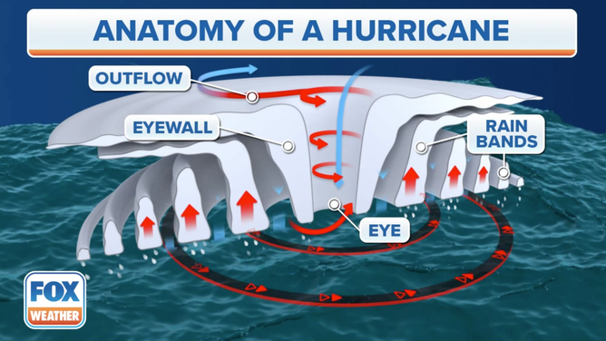
The outflow, eyewall, eye and rain bands are noted.
(FOX Weather)
Eye - A circular area of light winds and comparatively less cloud cover at the center of the hurricane. The eye is surrounded by the eyewall.
Eyewall - An organized circular cloud structure, made up of cumulonimbus clouds, partially or completely surrounding the eye, according to the NHC. The eyewall is also known as the wall cloud.
Outflow - Air that flows outward from the hurricane.
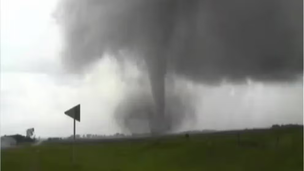
Rainbands - Curved bands of clouds and thunderstorms that trail away from the eye wall in a spiral fashion. These bands are capable of producing heavy bursts of rain and wind, as well as tornadoes. There are sometimes gaps in between spiral rain bands where no rain or wind is found.
Stages of a hurricane
Cyclone - A cyclone is simply an atmospheric closed circulation, rotating counter-clockwise in the Northern Hemisphere and clockwise in the Southern Hemisphere.
In terms of tropical weather, tropical cyclones in the Southwestern Pacific Ocean, are referred to as cyclones. This basin and climate, east of 90 degrees east longitude, is monitored by the Fiji Meteorological Service; New Zealand's MetService; Indonesia's Badan Meteorologi, Klimatologi, dan Geofisika; Papua New Guinea's National Weather Service; and the Australian Bureau of Meteorology. Any U.S. interests in those regions are covered by the Joint Typhoon Warning Center as well.
The Australian BOM uses its own 1-to-5 scale to categorize cyclones in its area of responsibility. This Australian tropical cyclone intensity scale uses different high wind speeds for its ratings than the U.S. uses for the Saffir-Simpson Hurricane Wind Scale.
Cyclonic storm - Tropical cyclones in the Northern Indian Ocean, which consists of the Arabian Sea and the Bay of Bengal, are called cyclonic storms once their winds reach 39 mph, equivalent to a tropical storm in the Atlantic.
At 55 mph, they become severe cyclonic storms, and at 74 mph, they are called very severe cyclonic storms – equivalent to a Category 1 hurricane on the Saffir-Simpson Hurricane Wind Scale. From there, the storm is called an extremely severe cyclonic storm at 104 mph and a super cyclonic storm at 138 mph.
Extratropical cyclone - A cyclone that has lost its tropical characteristics and is traveling poleward. Its energy source converted from the release of energy from latent heat of condensation (rising air from warm seawater condenses and releases energy) to the clash between warm and cold air masses. (This is also called a transition from a warm-core to a cool-core system.) Extratropical cyclones can still mean strong wind and heavy rain.
All cyclonic storms in the Northern Indian Ocean are monitored by the India Meteorological Department, as well as the JTWC for any U.S. interests in the region.
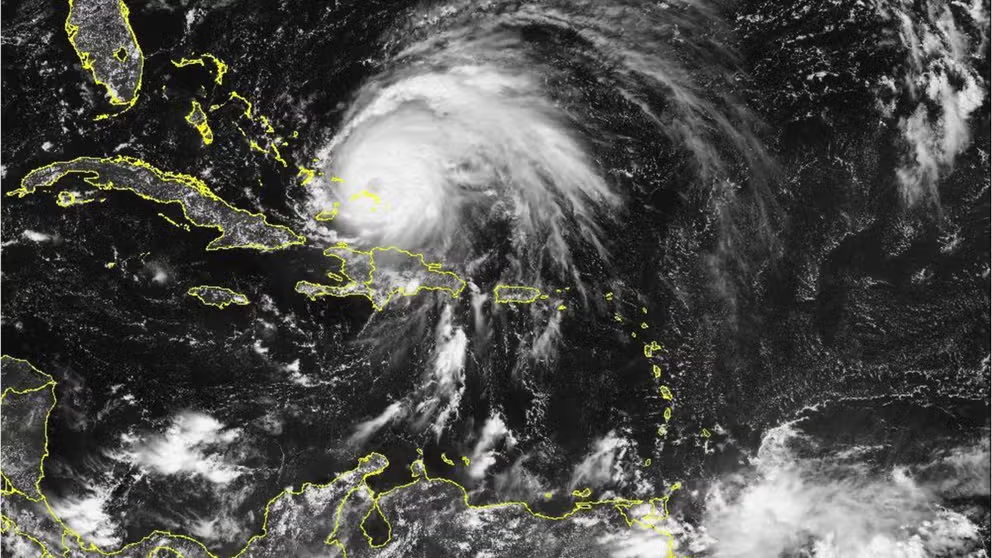
Hurricane - The term hurricane is used for all tropical cyclones with sustained winds of 74 mph or greater in the North Atlantic Ocean, Caribbean Sea, Gulf of Mexico and the Eastern and Central Pacific Ocean (from the west coasts of Mexico, Central America and the continental U.S. to the Hawaiian islands). These tropical storms are monitored by the Miami-based National Hurricane Center, except for the ones in the Central Pacific, which are monitored by the Central Pacific Hurricane Center in Honolulu, Hawaii.
Invest - An invest is simply a naming convention used by the NHC to identify an area of weather that it is investigating for possible development into a tropical depression or tropical storm within the next several days.
Landfall - The moment and point a tropical cyclone’s center intersects a coastline. The most violent weather is not necessarily at the storm’s center. Meteorologists also mention direct hit which is when the area of maximum winds hit a specific place. Areas experiencing hurricane force winds or tides 4 feet above normal but not a direct hit sustain an indirect hit. A hurricane strike is an area if it passes within the extent of hurricane force winds, according to the NHC. They define the usual area as within a circle that is about 144 miles in diameter, centered about 14 miles to the right of the hurricane’s center.
Post-Tropical Cyclone - A cyclone that no longer possesses tropical characteristics (i.e. warm core), according to the NHC. These storms continue to pose threats with heavy rain and high wind. A remnant low and extratropical cyclones are examples of post-tropical cyclones.
Remnant low - A post-tropical cyclone that has lost its convective organization (organized cloud development) and has maximum sustained winds lower than 39 mph.
Tropical Cyclone - A warm-core, low-pressure system with a well-defined center that is separated from a front and originates over tropical or subtropical waters.
The Southern Indian Ocean’s terminology is quite easy to remember, as it refers to hurricane-equivalent tropical cyclones simply as tropical cyclones. As they gain strength, they can be called intense tropical cyclones (104 mph) and very intense tropical cyclones (133 mph). Météo-France's La Réunion tropical cyclone center monitors this ocean basin, which stretches from Africa to 90 degrees east longitude. It's also covered by the JTWC to keep any U.S. interests informed during a storm.
Tropical Depression - A tropical cyclone with maximum sustained surface winds (for at least 1 minute) of 38 mph or less.
Tropical Disturbance - An area of apparently organized convection (vertical wind circulation), usually 120-350 miles in diameter that originated in the tropics or subtropics that has maintained its identity for at least 24 hours, according to the NHC.
Tropical Storm - A tropical cyclone with a maximum sustained wind (over a 1-minute average) between 39 mph and 73 mph.
Tropics, Sub-tropics - The tropics are an area stretching around the globe between 20 degrees north and south latitude across the equator. The sub-tropics reach around the globe from 35 degrees north and south latitude across the equator.
Typhoon - Tropical cyclones are called typhoons in the Western Pacific. Depending on where they are located in this basin, they can be monitored by the China Meteorological Administration, the Hong Kong Observatory, the Japan Meteorological Agency or PAGASA in the Philippines. In addition to the national meteorological services of each country, the United States’ Joint Typhoon Warning Center, headquartered in Pearl Harbor, Hawaii, also monitors the Western Pacific Basin to help protect U.S. military bases jointly operated with other countries, as well as any military ships or aircraft that might be in harm’s way.
The JTWC refers to a typhoon with maximum sustained winds of 150 mph or greater as a super typhoon. That’s the equivalent of a high-end Category 4 or Category 5 hurricane on the Saffir-Simpson Hurricane Wind Scale.
Tracking and studying hurricanes
National Hurricane Center - The NHC is a division within the National Oceanic and Atmospheric Administration. Their mission is to save lives, mitigate property loss and improve economic efficiency by issuing the best watches, warnings, forecasts and analyses of hazardous tropical weather and by increasing understanding of these hazards, according to the NHC.
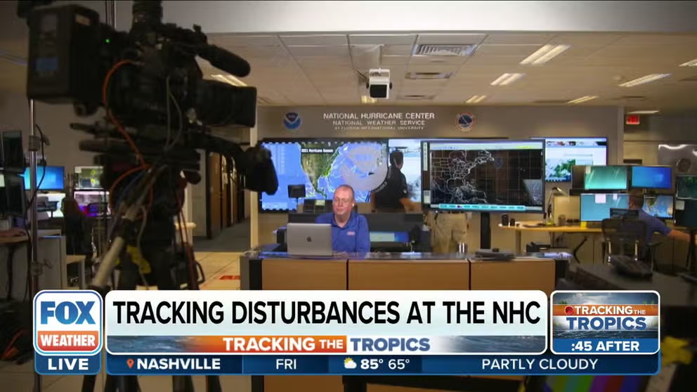
Behind-the-scenes look at how National Hurricane Center tracks tropical disturbances
FOX Weather multimedia journalist Brandy Campbell got a behind-the-scenes look at how the National Hurricane Center tracks tropical disturbances.
Hurricane names - The National Hurricane Center assigns a name to any tropical cyclone that becomes a tropical storm (39-plus-mph winds) or hurricane (74-plus-mph winds). The NHC goes through the list in alphabetical order, so the first tropical storm or hurricane receives the "A" name (Alex in 2022) and the 21st such storm receives the "W" name (Walter in 2022).
If we run through the alphabet, any additional storms now receive a name from a new supplemental list created by the World Meteorological Organization.
These name lists rotate every six years – a practice that began in 1979 – unless a particular storm is so destructive and/or deadly that the WMO votes to retire that name from future use, such as Harvey, Katrina, Michael or Sandy.
Hurricane Katrina caused severe destruction along the Gulf coast from central Florida to Texas.
(Universal History Archive/Universal Images Group / Getty Images)
Hurricane Hunters - Hurricane Hunters are part of the National Hurricane Center’s Aircraft Reconnaissance that uses airplanes to fly through some of the worst weather on the planet. Their mission is to gather valuable first-hand data for meteorologists at the National Hurricane Center so that they can fine-tune their forecasts.
The 53rd Weather Reconnaissance Squadron of the Air Force Reserves based in Biloxi, Mississippi, is also called Hurricane Hunters.

The National Hurricane Center monitored 97L in the eastern Atlantic.
(NOAA)
Dropsondes - Dropsondes are devices about the size of a Pringles can that are packed with weather instruments. They are released from a Hurricane Hunter plane and parachute into a hurricane.
The dropsonde measures things such as temperature, dew points, derived wind speed and direction and atmospheric pressure. As the dropsonde falls, it collects that information and then transmits a radio signal back to the aircraft. The information it gathers is used to build and refine forecast models.

How this hurricane hunter flies toward storms to study them
Commander Rebecca Waddington explains the work of NOAA Hurricane Hunters like herself. One aspect of their research involves releasing devices called "dropsondes" into hurricanes to gather data about the storms.
Saildrones - Saildrones are automated floating weather stations built by the company Saildrone. The weather stations are wind and solar-powered, remote-controlled and built to withstand the very worst Mother Nature can throw its way. The drones can travel about 3.5 mph and can remain deployed for about a year.
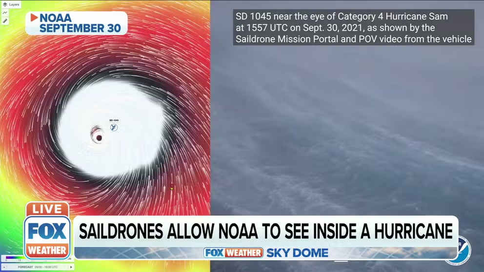
Saildrones allow NOAA to see inside the eye of hurricanes
Put out to sea this summer, saildrones have collected a season’s worth of data and dramatic images.
Cone of uncertainty - The projected path and intensity of a hurricane or tropical storm issued by the National Hurricane Center. It’s made of circles with radii that encompass two-thirds of the NHC’s official forecast errors over the most recent five-year period, plotted along the forecast track every 12 hours out to 72 hours (three days), then in 24-hour intervals out to 120 hours (five days).
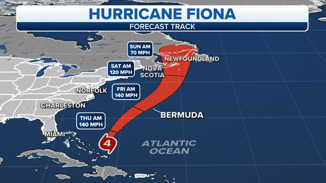
The cone of uncertainty for Hurricane Fiona, a powerful Category 4 hurricane as of September 21, 2022.
(FOX Weather)
Spaghetti plot - A diagram that shows multiple lines indicating possible paths a hurricane may take based on different models.

(FOX Weather)
Advisories
Hurricane Warning - A warning that is issued when sustained winds, or frequent gusts, of hurricane force (74 mph) or greater are expected to occur within 36 hours.
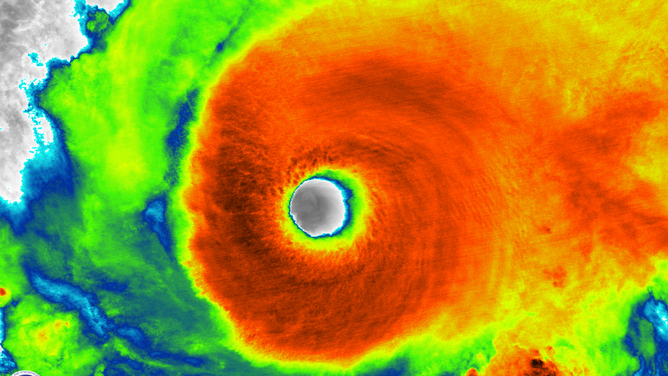
Satellite image of Hurricane Dorian on Aug. 31, 2019, at 2:48 a.m. Eastern time.
(NOAA/CIMSS)
Hurricane Watch - A watch for an increased risk of a hurricane-force wind event for sustained surface winds, or frequent gusts, of 74 mph or greater, but its occurrence, location, and/or timing is still uncertain.
These high winds are likely to be accompanied by storm surge, coastal flooding and/or river flooding. Emergency management officials warn that once winds reach around 40 mph, it becomes dangerous to continue to prepare for a storm.
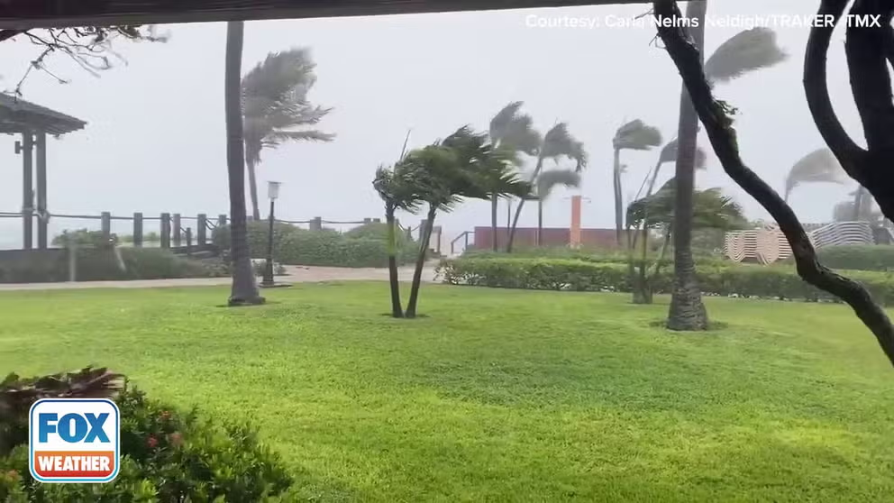
Wind from Hurricane Fiona whips across the Turks and Caicos
Video from the Turks and Caicos shows wind from major Hurricane Fiona's the outer bands lashing the island's shores.
Tropical Storm Warning - An announcement that tropical storm conditions (sustained winds of 39 to 73 mph) are expected somewhere within the specified coastal area within 36 hours.
Tropical Storm Watch - An announcement that tropical storm conditions (sustained winds of 39 to 73 mph) are possible within the specified coastal area within 48 hours.
Wind
Gust - A rapid fluctuation of wind speed with variations of 10 knots or more between peaks and lulls.
Major hurricane - A Category 3, 4 or 5 hurricane.
Maximum sustained winds - When applied to a particular weather system, refers to the highest one-minute average wind (at an elevation of about 33 feet with an unobstructed exposure) associated with that weather system at a particular point in time.
(FOX Weather)
Orographic lifting - Orographic lift occurs when air is forced up a mountainside and cools to the point of water vapor forming. The increased moisture can cause extensive cloud cover and heavy rainfall.
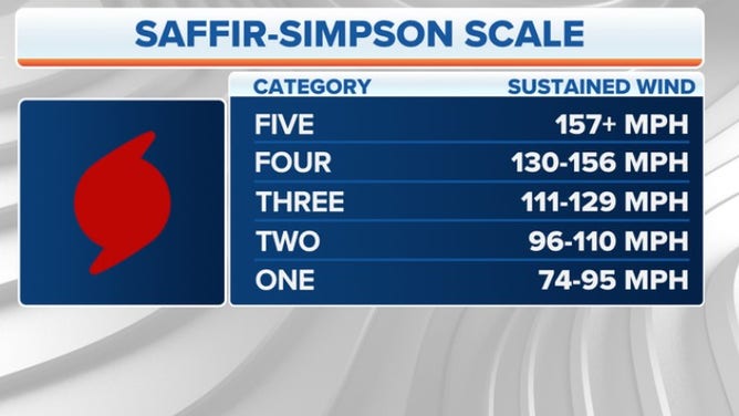
Saffir-Simpson Hurricane Wind Scale - This is a classification scale used to categorize hurricanes by the types of damage that can typically occur at various sustained wind speeds.
Wind shear - Wind shear involves changes in wind speed and/or direction with height. There are two types: directional wind shear, which happens when the wind moves in different directions in multiple layers of the atmosphere; and speed wind shear, or speed shear, which happens when the wind moves at different speeds in multiple layers of the atmosphere.
What is wind shear?
The two types of wind shear are directional and speed. Shear can aid in thunderstorms and tornadoes, but often hurt the formation of hurricanes.
Rapid intensification - Rapid intensification is a term used for tropical cyclones (tropical depressions, tropical storms and hurricanes) that – you guessed it – intensify at a rapid pace, but there are strict criteria a storm must meet to officially undergo rapid intensification. Rapid intensification occurs when a tropical cyclone's maximum sustained winds increase by at least 35 mph in a 24-hour period.
What does it mean when a hurricane undergoes rapid intensification?
Rapid intensification is a term used for tropical cyclones (tropical depressions, tropical storms and hurricanes) that – you guessed it – intensify at a rapid pace, but there are strict criteria a storm must meet to officially undergo rapid intensification.
Water
Rainfall - The amount of precipitation of any type, primarily liquid. It is usually the amount that is measured by a rain gauge. Refer to rain for rates of intensity and quantitative precipitation for forecasting.
Rip current - Strong, narrow currents that move away from the shore and out to sea at high speed, occurring at any beach that has breaking waves – even the Great Lakes. They can occur on sunny days when one would believe it’s unsafe to swim in the ocean.
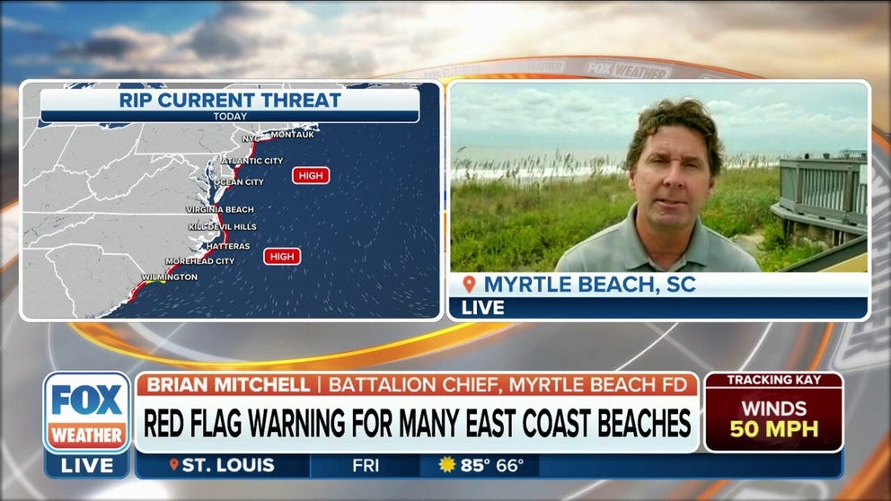
Hurricane Earl bringing strong rip currents to East Coast
Hurricane Earl is bringing strong rip currents to the East Coast with increased swell action and wave height. Brian Mitchell, Battalion Chief with the Myrtle Beach Fire Department, discusses the effects of Earl on the beach.
Storm surge - An abnormal rise in sea level accompanying a hurricane or other intense storm, whose height is the difference between the observed level of the sea surface and the level that would have occurred in the absence of the cyclone. Storm surge is usually estimated by subtracting the normal or astronomic tide from the observed storm tide.
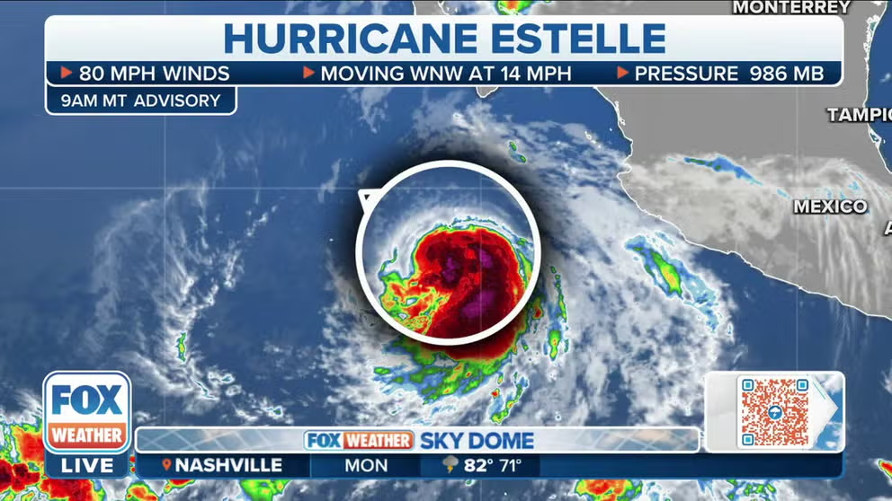
Hurricane Estelle sending ocean swells towards Mexico, Baja California peninsula
Rough seas and high swells are impacting Mexico, including the Baja California peninsula from Hurricane Estelle.
Swells - Wind-generated waves that have traveled out of their generating area. Swells characteristically exhibit smoother, more regular and uniform crests and a longer period than wind waves.
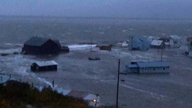
Storm surge floods the town of Golovin, Alaska as a massive storm moves through on Sept. 17, 2022.
(C. Lewis via National Weather Service, Fairbanks)
Sea-surface temperatures - This term refers to the mean temperature of the ocean in the upper few feet.