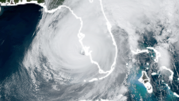
Hurricane Ian's destructive winds spread across Florida Peninsula
Hurricane Ian's destructive winds spread across Florida Peninsula
Download the AppContinuing coverage of Hurricane Ian
View postCoverage for this event has ended.
Live coverage of Hurricane Ian has ended here. Live coverage of Hurricane Ian for Thursday, 09/29 is now available by clicking here.
Deputies came to the rescue of two boaters near Jacksonville on Wednesday evening. Winds were gusting to tropical storm-force during around the time of the rescue. Fortunately, there were no reported injuries.
Track Hurricane Ian: Click Here
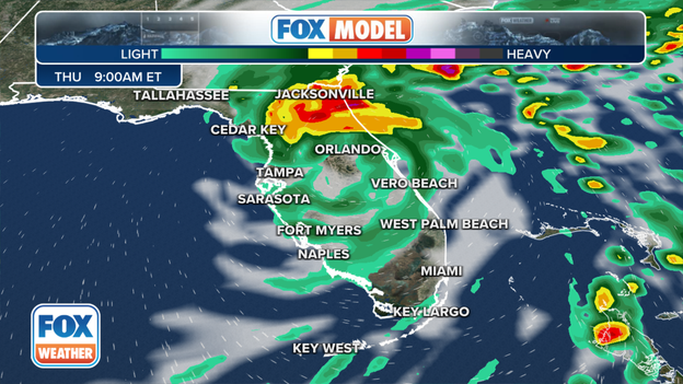
FOX Forecast Center Model for future movements of Ian
As of 11 P.M., Hurricane Ian had maximum sustained winds around 90 mph. This makes the hurricane a Category 1 on the Saffir-Simpson Hurricane Wind Scale.
The hurricane is about 70 miles south of Orlando.
Winds of at least tropical storm-force will continue to impact the Peninsula through Thursday.
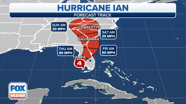
Once the cyclone exists Florida's East Coast, it will head in the direction of South Carolina.
The FOX Forecast Center is tracking the future movement of Ian: Click Here
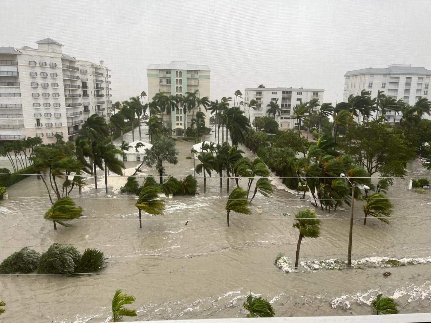
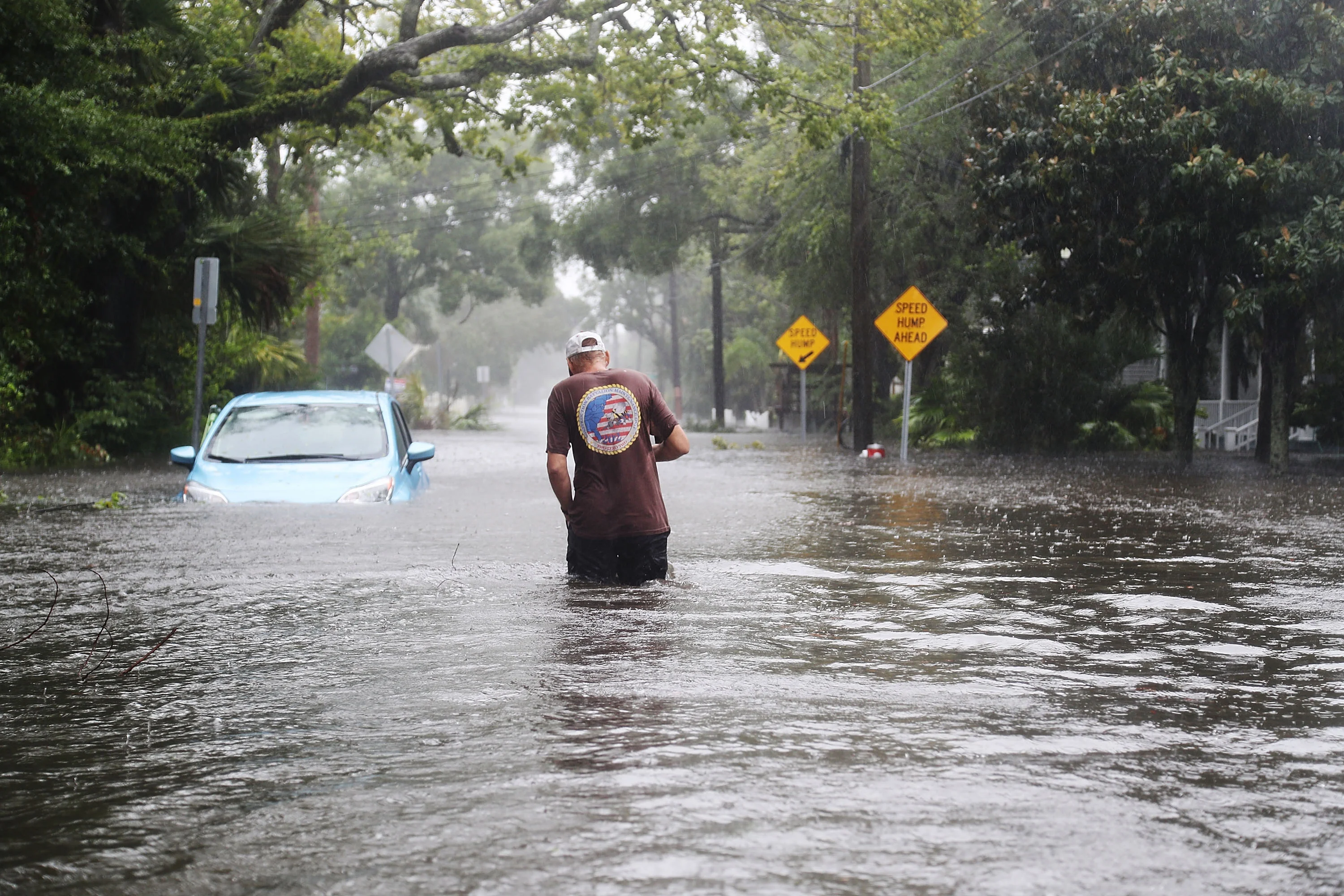
Firefighters responded to dozens of rescues in Southwest Florida as Hurricane Ian produced several feet of storm surge. Firefighters in Naples were forced to break out the window of a car to save a driver from a flooded car.
Flooding is the top weather-related in hurricanes: 'Turn around, don't drown'
Tracking Hurricane Ian
As of 10 P.M., Hurricane Ian had maximum sustained winds around 100 mph. This makes the hurricane a Category 2 on the Saffir-Simpson Hurricane Wind Scale.
The hurricane is about 80 miles south of Orlando.
A dangerous storm surge will continue Thursday and Friday along the coasts of Northeast Florida, Georgia and South Carolina.
Here is what the FOX Forecast Center is tracking: Click Here
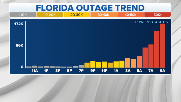
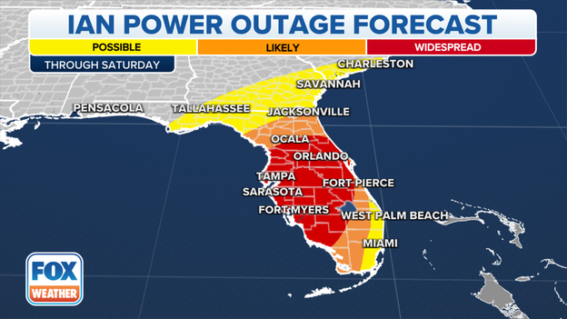
Power outages
Power is out for 2 million people in Florida tonight after Hurricane Ian struck Florida this afternoon.
The Category 4 had winds of 150 mph when it made landfall.
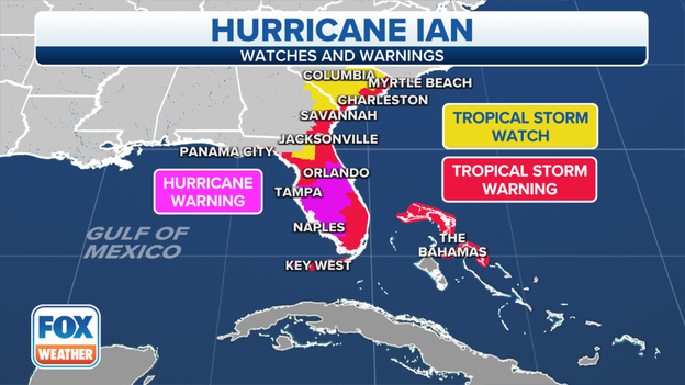
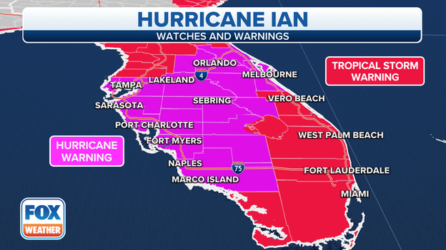
FOX Weather warning map
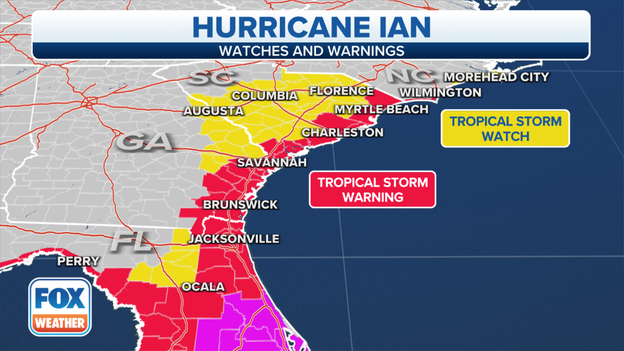
Tropical Storm Watches and Warnings have been issued for parts Georgia and South Carolina as a much weakened Ian is expected to reemerge in the Atlantic Ocean and make another U.S. landfall along the coast. The landfall could happen as early as Friday evening. Here is what the FOX Forecast Center is tracking: Click Here
Fort Myers was one of several communities along the Gulf Coast that was hard hit during Hurricane Ian's landfall. Nearly the entire region is without power and many homes an businesses were inundated by floodwater. See more: Click Here
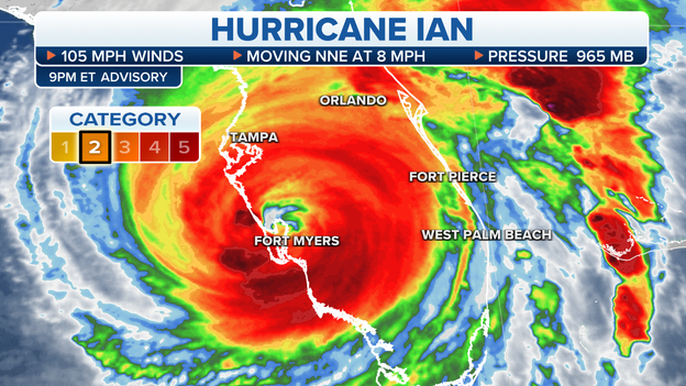
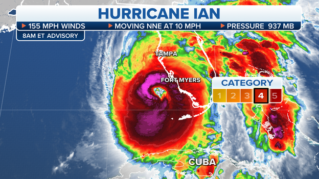
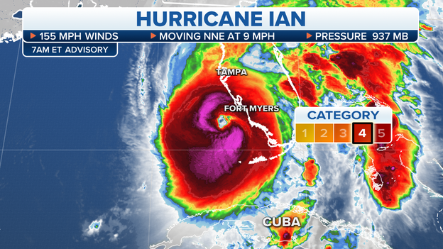
Hurricane Ian is no longer a major hurricane. In the latest 9 pm ET advisory, Ian has been downgraded to a Category 2 storm with winds of 105 mph. The hurricane still produces significant impacts.
Forecast cone from Hurricane Ian
As of 9 P.M., Hurricane Ian continues weaken over Florida but is producing significant impacts
Maximum sustained winds have dropped to 105 mph, a Category 2 hurricane.
A dangerous storm surge will continue Thursday and Friday along the coasts of Northeast Florida, Georgia and South Carolina.
Flash Flood Emergencies have also been issued as torrential rain continues within Florida.
In the latest 8pm ET advisory, Hurricane Ian is a Category 3 storm with winds of 115 mph. Catastrophic storm surge is ongoing and damage is taking place as the eye moves northward through The Sunshine State.
The National Weather Service has issued a Flash Flood Emergency is in effect until 10:45 p.m. ET for parts fo Charlotte, DeSoto, Hardee, Highlands, Manatee and Sarasota counties.
Between 12 and 19 inches of torrential rain has already fallen over some areas within the flood alert.
The FOX Forecast Center is tracking between 3 to 8 more inches of rain forecast over these areas.
A Flash Flood Emergency is the most dire of all the flood alerts that can be issued by the NWS.
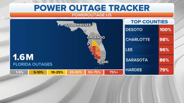
Power outages as of 7:30 p.m. ET
More than 1.6 million people are in the dark after Hurricane Ian made landfall in Florida this afternoon.
Poweroutages.us shows that Floridians are continuing to lose power as the hurricane tracks north through the Sunshine State.
FOX Weather Hurricane Specialist Bryan Norcross is warning Central Florida, including the Orlando metro area, to prepare for flooding from Hurricane Ian.
Now a Category 3 hurricane, Ian continues to pack 125 mph winds as it moves inland and up the I-4 corridor.
Between 18 to 24 inches of rain is forecast in Central Florida which could create dangerous flash flooding.
Ian's outer bands are lapping at the Jacksonville coast.
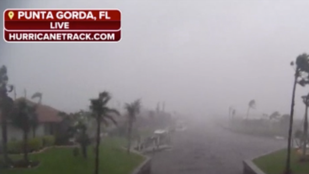
Live look from Punta Gorda, FL
As of 7 P.M., Hurricane Ian continues to move northeast through Florida, brining catastrophic storm surge to the coastline.
Maximum sustained winds remain around 125 mph, making the storm a dangerous Category 3.
The National Hurricane Center says that the storm surge inundation of 12 to 18 feet above ground level along with destructive waves is ongoing along the southwest Florida coastline.
Storm Surge Watches, Tropical Storm Warnings and Tropical Storm Watches have been issued from Florida northward through North Carolina.
Heavy rain will continue to spread across the Florida peninsula through Thursday.
Ian will continue to weaken while it moves inland across Florida into Thursday but may retain hurricane or near-hurricane strength once it reaches the northeastern Florida coast. It is then expected to reemerge over the Atlantic Ocean later Thursday.
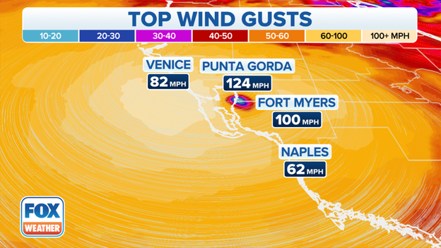
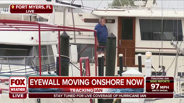
Fort Myers top wind gusts.
FOX Weather correspondent Will Nunely is in Fort Myers where winds are pushing over trees and sending debris flying.
"Everything is turning into a projectile," Nunley said of the debris.
Hurricane Ian continues to maintain Category 4 strength after making landfall earlier today.
At 5:20 p.m. EDT, a Cape Coral reporting station reported a wind gust of 140mph.
Hurricane Ian will continue to bring its damaging winds through the Florida Peninsula through tomorrow.
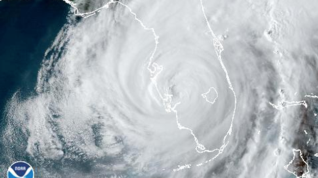
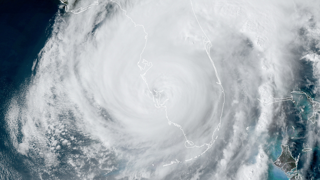
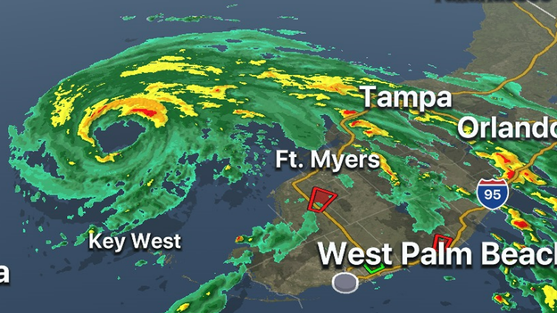
Satellite imagery of Hurricane Ian
As of 6 P.M., Hurricane Ian continues to move northeast through Florida.
Maximum sustained winds remain around 130 mph, making the storm a Category 4 hurricane.
Storm Surge Watches, Tropical Storm Warnings and Tropical Storm Watches have been issued from Florida northward through North Carolina.
Ian will move across central Florida Wednesday night and Thursday morning and reemerge over the Atlantic Ocean later Thursday.
Ian will continue to weaken while it moves inland across Florida into Thursday but may retain hurricane or near-hurricane strength once it reaches the northeastern Florida coast.
Florida Gov. Ron DeSantis and FDEM Director Kevin Guthrie provided an update on Florida's response to Hurricane Ian.
"It’s going to rank as one of the top five hurricanes to ever hit the Florida peninsula," DeSantis said of Ian.
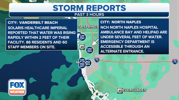
Hurricane Ian storm reports coming into the FOX Forecast Center.
Multiple reports from the past three hours have come in of water entering healthcare facilities, including NCH North Naples Hospital and Solaris Healthcare.
Naples Fire Station 1 is flooded, included fire engines mostly submerged. The Naples Municipal Airport EMS Station was evacuated due to rising waters.
Video near downtown Naples shows downed power lines sparking a fire.
After the storm, people should stay away from downed power lines and not attempt to move them even if in the road.
FOX Weather Hurricane Specialist Bryan Norcross explains that as Hurricane Ian expands this could later be a problem for North Florida and Georgia and the Carolinas.
Tropical Storm Watches and Warnings now extend into southeast Georgia and the South Carolina coast.

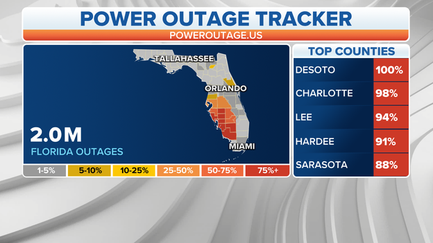
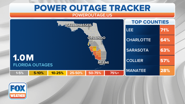
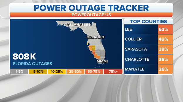
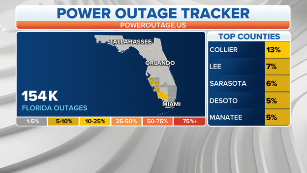
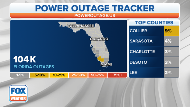
FOX Weather power outage tracker with data from poweroutage.us.
Lee, Charlotte, Sarasota and Collier counties make up the majority of power outages from Hurricane Ian in Florida.
More than 2 hours since landfall over 1.1 customers are in the dark.
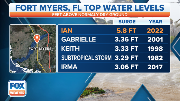
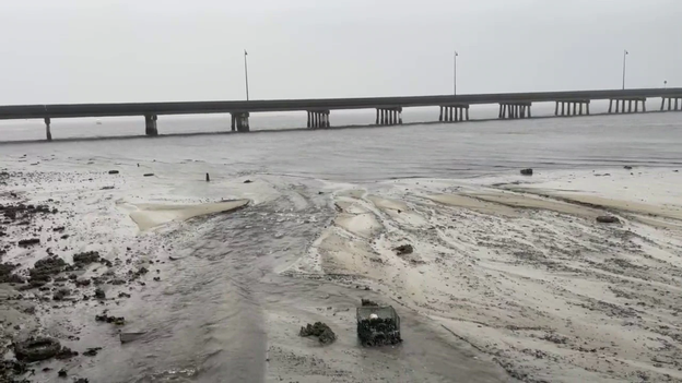
Fort Myers, Florida record flooding from tropical systems.
Fort Myers has reached 5.8 feet storm surge breaking the previous record set by Hurricane Gabrielle in 2001 at 3.36 feet.
FOX Weather correspondent Robert Ray is in Fort Myers where roads are now flowing with water.
Hurricane Ian is forecast to bring up to 18 feet of storm surge from Bonita Springs to Punta Gorda.
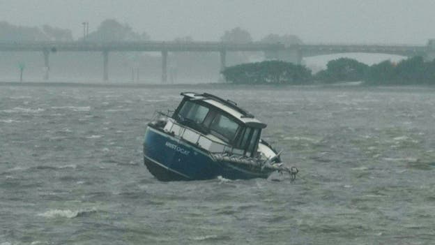
A boat rocks in the waves in the Gulf of Mexico in Dunedin, Florida ahead of Hurricane Ian making landfall
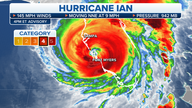
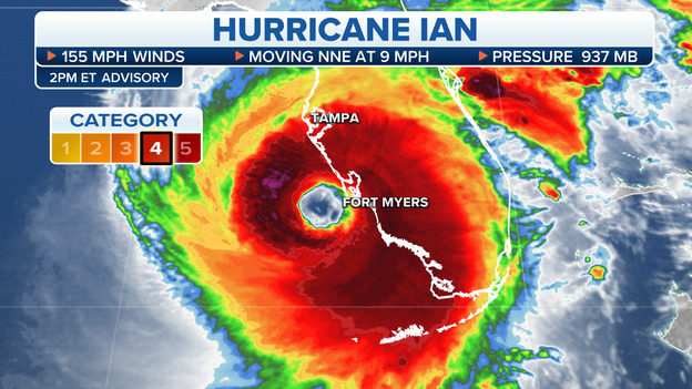
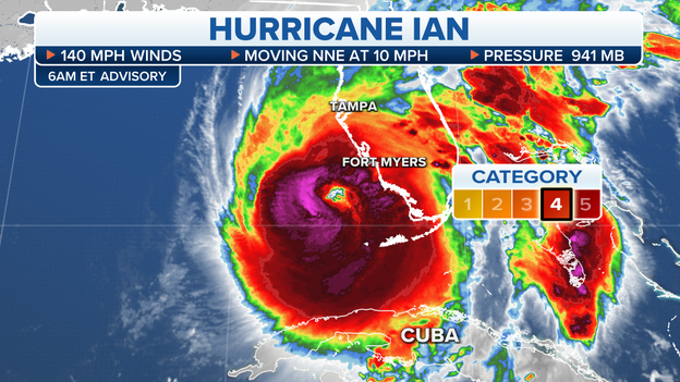
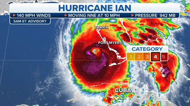
Hurricane Ian is still hammering southwestern Florida as the Category 4 storm continues its trek inland.
Peak winds have dropped a little to 140 mph as the eye moves ashore on a north-northeast track at 8 mph, according to the National Hurricane Center. The center of the storm is just 5 miles east of Punta Gorda, Florida as of 5 p.m. ET. The central pressure is at 945 millibars.
Hurricane-force winds now expand 50 miles from the center and several wind gusts over 100 mph were observed near where the storm made landfall. Punta Gorda reported a gust of 124 mph while a station in Grove City hit 128 mph.
Ian will move across central Florida Wednesday night and Thursday morning and reemerge over the Atlantic Ocean later Thursday.
Ian will continue to weaken while it moves inland across Florida into Thursday but may retain hurricane or near-hurricane strength once it reaches the northeastern Florida coast.
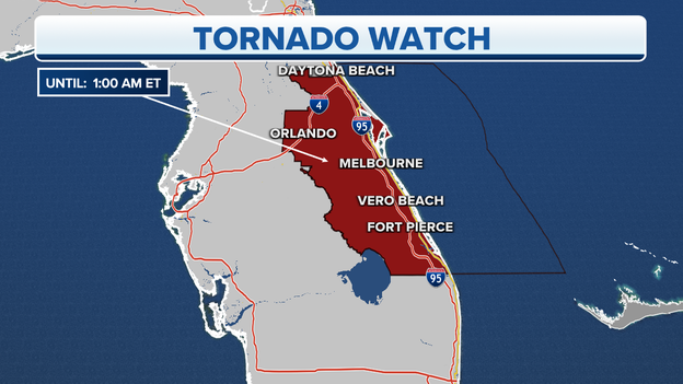
A Tornado Watch in effect in central, eastern Florida until 1 a.m.
The National Weather Service issued a new Tornado Watch for parts of central and eastern Florida until 1 a.m.
The Tornado Watch includes the cities of: Daytona Beach, Orlando, Melbourne, Vero Beach and Fort Pierce.
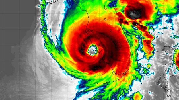
GOES 16 satellite image showing Hurricane Ian making a second landfall.
After making an initial landfall at Cayo Costa, Florida at 3:05 p.m. ET, Hurricane Ian made a second landfall on the mainland of southwestern Florida just south of Punta Gorda near Pirate Harbor, according to the National Hurricane Center.
Maximum sustained winds at this landfall were estimated to be 145 mph -- a weakening of 5 mph from Ian's initial landfall at Cayo Costa.

Listen as field meteorologist Brett Adair describes the scene in Punta Gorda, Florida, as Hurricane Ian lashes the region with destructive wind, torrential rain and a life-threatening, catastrophic storm surge on Wednesday afternoon.
More than 1 million power outages have been reported in Florida because of Hurricane Ian.
Hurricane Ian made landfall in southwestern Florida on Wednesday afternoon and caused more than 1 million power outages as the monster Category 4 storm lashed the state with destructive wind and torrential rain.
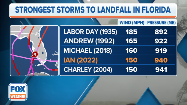
These are the five strongest hurricanes to ever make landfall in Florida.
Category 4 Hurricane Ian had maximum sustained winds of 150 mph at landfall in Southwest Florida on Wednesday afternoon.
That intensity tied with Hurricane Charley in 2004 as Florida's fourth-strongest landfall on record.
Only 2018's Hurricane Michael (160 mph), 1992's Hurricane Andrew (165 mph) and the 1935 Labor Day Hurricane (185 mph) had higher sustained winds when moving onshore in Florida.
Click here to read more about Florida's most intense hurricane strikes.
Hurricane Ian is centered about 10 miles west-southwest of Punta Gorda, Florida.
Hurricane Ian is moving inland across the Cape Coral-Punta Gorda area of Southwest Florida. Ian remains a powerful Category 4 hurricane with maximum sustained winds estimated at 145 mph.
The Punta Gorda airport recently reported a wind gust of 124 mph, and a station at the Cape Coral Fire Department recently reported a wind gust of 110 mph.
The center of Hurricane Ian was last reported to be 10 miles west-southwest of Punta Gorda, Florida, or 20 miles northwest of Fort Myers, Florida.
The Naples Fire-Rescue Department recorded video of first responders rescuing a woman from the water as Hurricane Ian moved closer to the coast.
Video recorded by the Naples Fire-Rescue Department shows water flooding the station during Hurricane Ian and a smoking fire truck that needed to be pushed outside because it was smoking.
Approximately 1,200 Tennessee National Guardsmen, including three Blackhawk helicopters, have been deployed to Florida to assist in the recovery of Hurricane Ian.
Hurricane Ian made landfall in southwestern Florida just after 3 p.m. Wednesday as a powerful Category 4 storm with winds of 150 mph.
More than 800,000 utility customers now in the dark in Florida.
Shortly after Hurricane Ian's landfall, an FP&L spokesperson said about 800,000 customers are without power and they expect that number to increase.
"We won't know until the flood water recede just how many customers are impacted," FP&L's Dave Reuter joined FOX Weather to discuss power outages on Wednesday afternoon.
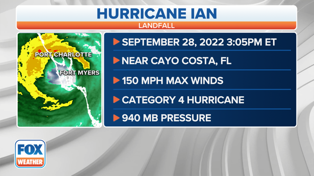
Hurricane Ian makes landfall near Cayo Costa, Florida, on Wednesday afternoon.
Watch the moment when the FOX Forecast Center announces that Hurricane Ian made landfall just after 3 p.m. near Cayo Costa, Florida, with winds of 150 mph.
A catastrophic, life-threatening storm surge is expected to continue as hurricane Ian continues to move inland.
Flagler County officials on Florida's east coast have announced a curfew starting at 8 p.m. until 7 a.m. Thursday due to Hurricane Ian.
The curfew includes the entire county.
“This is about protecting human life and property,” Emergency Management Director Jonathan Lord said. “We will lift it as soon as possible, but there are a lot of unknowns with this storm.”
Satellite image showing the imminent landfall of Hurricane Ian.
Hurricane Ian has made landfall as a strong Category 4 hurricane with 150 mph winds.
Radar imagery shows the eye moved ashore at Cayo Costa at 3:05 p.m. ET, according to the National Hurricane Center.
Several gusts over 100 mph have been measured so far, with a gust as high as 126 mph at Redfish Pass as the eye wall moves ashore.
The National Weather Service issued an Extreme Wind Warning in southwestern Florida that includes more than 1.2 million people.
Areas included in the Extreme Wind Warning are Arcadia, Hull, Osprey, Venice, North Port, Port Charlotte, Englewood, Rotonda, Bokeelia, Matlacha, Fort Myers Shores, Cape Coral, Lehigh Acres, Captiva, Sanibel, Estero and Bonita Springs.
People includes in the Extreme Wind Warning should treat this warning as a Tornado Warning.
Get into an interior room in the lowest level of a building and stay away from doors and windows.
Trees are beginning to come down and stop signs are flying in Fort Myers where FOX Weather multimedia journalist Will Nunley is reporting on Hurricane Ian.
Some power outages are also happening around him.
A race track gas station just lost power behind him moments ago.
"Everything around us is going dark," Nunley said.
Hurricane Ian is roaring ashore as a powerful Category 4 hurricane, and the storm is pushing water on shore causing a life-threatening, catastrophic storm surge.
FOX Weather correspondent Robert Ray is in Fort Myers, Florida as powerful Hurricane Ian knocks out power to more than 625,000 utility customers in the state.
More than 624,000 power outages have now been reported in Florida as Hurricane Ian starts to roar ashore in southwest Florida.
The highest outages have been reported in Lee, Collier and Sarasota counties.
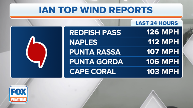
126 mph wind gust reported as Hurricane Ian starts to roar ashore
Several wind gusts across southwestern Florida have topped 100 mph, including a 126 mph gust in Redfish Pass.
Other top wind gusts from Hurricane Ian include:
Naples – 112 mph
Punta Rassa – 107 mph
Punta Gorda – 106 mph
Cape Coral – 103 mph
As Hurricane Ian's landfall is imminent, the power of the storm is leading to record-breaking and life-threatening storm surge along Florida's southwestern coast.
Hurricane Ian is centered 25 miles west-northwest of Fort Myers, Florida.
Hurricane Ian remains a high-end Category 4 hurricane with maximum sustained winds of 155 mph as it heads for a catastrophic landfall in Southwest Florida in the next hour or two.
Ian is crawling toward the north-northeast at just 9 mph and is currently centered 25 miles west-northwest of Fort Myers, Florida.
Catastrophic impacts are expected from Hurricane Ian's storm surge, destructive winds and life-threatening flooding across the Florida Peninsula.
A River, Estuary and Coastal Network station at Redfish Pass, Florida, recently reported sustained winds of 94 mph and a gust of 126 mph.
A Weatherflow station at Tarpon Point, Florida, recently reported sustained winds of 83 mph with a gust to 101 mph.
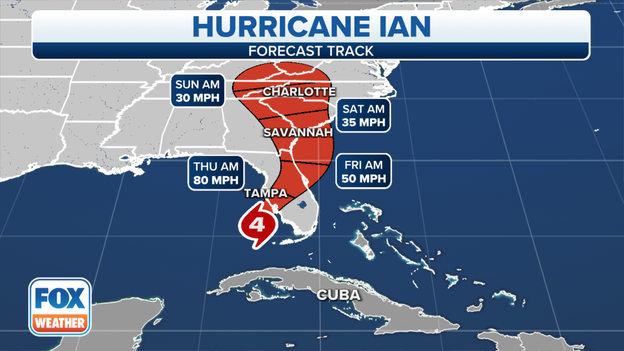
After Ian's landfall between Sarasota and Fort Myers, the hurricane will move over Central Florida Wednesday night and Thursday morning and emerge over the western Atlantic by late Thursday.
Ian is forecast to turn northward on Friday and approach the northeastern Florida coast, in addition to the Georgia and South Carolina coasts, by late Friday.
Incredible video from Naples, Florida, shows powerful and destructive winds from Hurricane Ian whipping through a homeowner's yard.
Hurricane Ian's landfall is imminent along Florida's southwestern coast.
Florida officials are requiring the state’s nursing homes and assisted living facilities to report their patient populations.
More than 7,000 patients in the path of Hurricane Ian were evacuated ahead of landfall.
Nursing homes and assisted living centers were required to make storm upgrades after South Florida 12 patients died following Hurricane Irma in 2017.
AHCA Secretary Simone Marstiller said 100% of the state’s long-term care facilities have generators on site.
Ahead of Ian, state healthcare staff completed hundreds of on-site visits to make sure facilities were ready for the storm.
Video recorded in southwest Fort Myers shows powerful winds whipping through palm trees as Hurricane Ian approaches.
Landfall is imminent, according to forecasters.
Satellite image of Hurricane Ian at 2 p.m. Eastern time. (NOAA)
The FOX Forecast Center expects Hurricane Ian's landfall to occur within the next two hours.
Hurricane Ian has slowed to a crawl as it approaches the coastline of Southwest Florida, so its landfall might be slightly delayed.
The city of Naples, Florida , has announced an emergency citywide curfew that is effective immediately as Hurricane Ian begins to move onshore.
This order is to protect the health, safety and welfare of Naples residents, visitors and first responders, according to city officials.
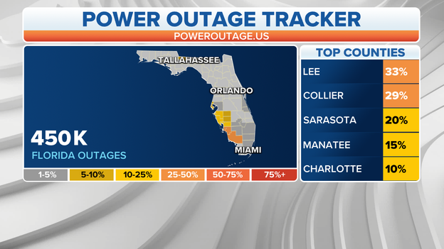
At least 450,000 power outages have been reported in Florida due to Hurricane Ian
Power outages associated with Hurricane Ian in Florida continue to skyrocket, and now at least 450,000 outages have been reported.
Those numbers are expected to climb as Hurricane Ian moves onshore in southwestern Florida.
The city of Orlando has opened parking garages to the public for cars only as Hurricane Ian gets close to landfall.
Pay attention to the clearances as exceeding the limits could damage the vehicle and structure.
The Key West Police Department is urging people to stay out of standing water caused by Hurricane Ian.
Downed power lines and other hazards may be in the water, and that could put your life in danger.
FOX Weather correspondent Max Gorden shares video of the "reverse storm surge" in Tampa Bay.
Water has been sucked from the bay as Hurricane Ian approaches, and will likely rush back as the storm advances.

Hurricane Hunter Pilot Maj. Kendall Dunn described his flight into Hurricane Ian right before landfall as one of the roughest of his career.
When the pilot did get a clearing to come through the eyewall, they experienced the worst turbulence of Dunn's career.
"We got rocked," Dunn said. "The aircraft was basically overmatched at one point. We were max-power, trying to gain speed. We were basically diving, losing air. It was a mess. It was the worst thing you could have to happen as a pilot."
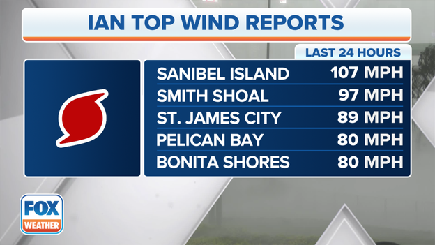
A 107 mph wind gust was reported on Sanibel Island on Wednesday afternoon.
Strong wind gusts have been reported across southwestern Florida due to Hurricane Ian, including a wind gust of 107 mph on Sanibel Island.
Other gusts include:
Smith Shoal – 97 mph
St. James City – 89 mph
Pelican Bay – 80 mph
Bonita Shores – 80 mph
A Twitter user recorded several videos of the impact that Hurricane Ian is having on the Naples area.
The video shows flooded streets and strong winds battering the area.
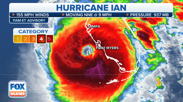
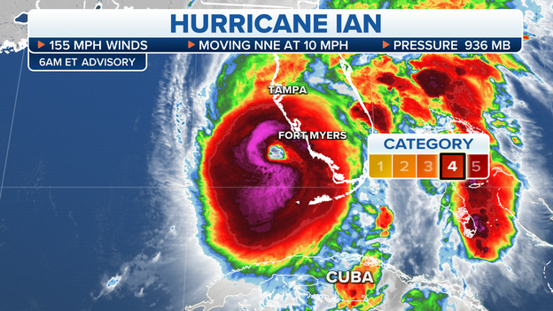
Hurricane Ian is currently a Category 4 hurricane with winds of 155 mph.

Satellite image of Hurricane Ian on Wednesday afternoon.
Hurricane Ian remains a high-end Category 4 hurricane with maximum sustained winds of 155 mph. The catastrophic hurricane's eyewall is currently spreading hurricane-force winds (74-plus mph) and torrential rainfall across parts of Southwest Florida.
The center of Ian is located about 35 miles west-southwest of Fort Myers, Florida, or 45 miles southwest of Punta Gorda, Florida. Landfall is expected to occur later Wednesday afternoon as Hurricane Ian's center moves onshore in Southwest Florida.
The Earth Networks Station at the Naples Grande Beach Resort recently reported a wind gust of 112 mph.
A Weatherflow station near Sanibel Island, Florida, recently reported sustained winds of 77 mph and a gust of 107 mph.
A River, Estuary and Coastal Network station at Redfish Pass, Florida, recently reported sustained winds of 75 mph and a gust of 100 mph.
FOX Weather correspondent Max Gorden shows us what the conditions are like in St. Petersburg.
He says water has been sucked out of Old Tampa Bay ahead of Hurricane Ian's arrival.
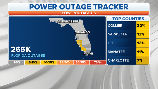
Power outages in Florida have topped 265,000.
Power outages in Florida have topped 265,000 and more are expected as Hurricane Ian begins to move onshore in southwestern Florida.
Those numbers are expected to climb due to the effects of the hurricane.
FOX Weather correspondent Robert Ray shared video of strong winds battering Fort Myers as Category 4 Hurricane Ian moves closer to shore.
FOX Weather multimedia journalist Will Nunley is in Fort Myers, Florida, where conditions are rapidly deteriorating as Hurricane Ian begins to move onshore.
An Extreme Wind Warning has been issued for southwestern Charlotte and south-central Sarasota counties until 2 p.m.
This warning is associated with the eyewall of Hurricane Ian moving onshore in the area.
People are urged to take this Extreme Wind Warning as seriously as a Tornado Warning.
Get to an interior room in the lowest level of a building and stay away from doors and windows.
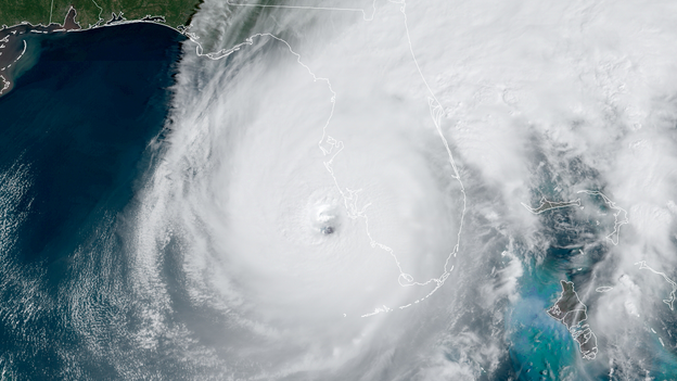
Satellite image of Hurricane Ian near the coast of Southwest Florida. (NOAA)
Category 4 Hurricane Ian continues to pack winds of 155 mph as its eyewall moves onshore at Sanibel and Captiva islands in Southwest Florida.
As of 12 p.m. Eastern, the center of Ian was located 45 miles southwest of Punta Gorda, Florida, or 50 miles west-northwest of Naples, Florida.
A Weatherflow station near Sanibel Island, Florida, recently reported sustained winds of 71 mph and a gust of 98 mph.
A River, Estuary, and Coastal Network station at Redfish Pass recently reported sustained winds of 67 mph and a gust of 84 mph.
The center of Hurricane Ian is expected to make a catastrophic landfall in Southwest Florida on Wednesday afternoon.
The FOX Weather stream is now available to watch live on YouTube as Hurricane Ian approaches Florida.

An outpouring of federal resources have moved to Florida in preparation for Hurricane Ian.
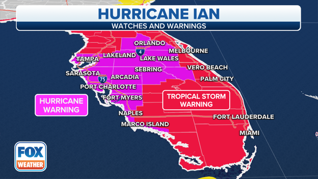
Hurricane and Tropical Storm Warnings are posted in Florida. (FOX Weather)
The National Hurricane Center has expanded the Hurricane Warnings in Florida to now include areas from Sebastian Inlet northward to the Flagler/Volusia County line along the state's Atlantic coast.
Elsewhere in Florida, Hurricane Warnings extend from Chokoloskee to the Anclote River, which includes the Tampa Bay area.
A Hurricane Warning is also posted for the Dry Tortugas.
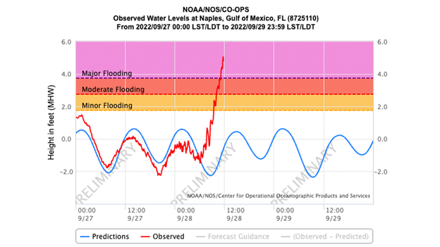
Naples, Florida, is now at a record storm surge at 4.8 feet.
Naples, Florida, is now at a record storm surge at 4.8 feet.
As FOX Weather meteorologist Britta Merwin explains in this video, he previous record was 4.25 feet and was set during Hurricane Irma in 2017.
Acting Deputy Director for the National Hurricane Center Michael Brennan speaks with FOX Weather meteorologists Amy Freeze and Craig Herrera , as well as FOX Weather hurricane specialist Bryan Norcross about the impacts Hurricane Ian will have on Florida.
FOX Weather multimedia journalist Will Nunley is in Fort Myers, Florida, where conditions have been deteriorating all morning as Hurricane Ian batters the region.
Hurricane Ian is currently a Category 4 storm with winds of 155 mph.
Check out this ominous satellite loop of Hurricane Ian spinning off the southwestern coast of Florida on Wednesday morning.
Hurricane Ian is currently a Category 4 hurricane with winds of 155 mph.
The hurricane’s eyewall is starting to move onshore.
The wind is starting to pick up in Orlando as Hurricane Ian begins to move onshore in southwestern Florida .
FOX Weather digital content producer Emilee Speck shot this video as the effects from Hurricane Ian begin to pick up.
A Hurricane Warning is now in effect in the Orlando area.
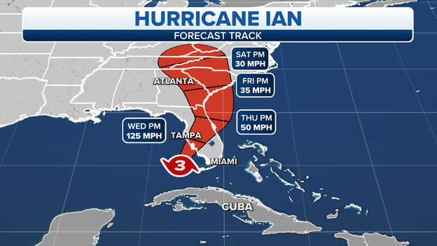
The projected path and intensity of Hurricane Ian.
Although the eyewall of Hurricane Ian, which contains the most destructive winds, is already moving onshore in Southwest Florida, an official landfall doesn't occur until the actual center of the hurricane moves onshore.
According to the National Hurricane Center, the center of Hurricane Ian should cross the coastline in Southwest Florida on Wednesday afternoon, but the peak impacts are already developing in the area.
An Extreme Wind Warning is in effect for central Lee County in Southwest Florida until 12:45 p.m. Eastern because of the expected catastrophic wind damage associated with Hurricane Ian's eyewall.
Extreme Wind Warnings were implemented by the National Weather Service after Hurricane Charley brought widespread tornado-like damage to this same region in 2004.
The NHC says the center of Ian is expected to make landfall in Southwest Florida as a catastrophic hurricane within the next few hours, likely between the Sarasota, Port Charlotte and Fort Myers areas.
A man is seen standing on a boat in Fort Myers as Hurricane Ian's eyewall begins to move onshore
FOX Weather correspondent Robert Ray is in Fort Myers, Florida, as Hurricane Ian 's eyewall begins to move onshore.
During his report, Ray spotted a man standing on his boat as conditions began to deteriorate rapidly.
Ray is in downtown Fort Myers about 45 miles from the center of Hurricane Ian where storm surge is expected to be up to 18 feet.
"I think we're going to see unbelievable numbers," Ray said, adding "it's just not safe for anyone to be out anymore."
This video from the Naples Fire-Rescue Department Facebook page shows what appears to be an electrical fire as strong winds from Hurricane Ian rip away power lines.
Widespread power outages are expected as the hurricane moves onshore.
Water is being sucked out of Charlotte Harbor in Florida as Hurricane Ian nears.
Watch this eerie video of water being sucked from Charlotte Harbor in Florida as Hurricane Ian continues to lash the coast with torrential rain and destructive winds.
Officials say operations have ceased at Orlando International Airport as Hurricane Ian begins to move onshore on Florida's west coast.
Passengers are asked to contact their airlines directly in regards to travel plans.
The center of Ian is located about 45 miles west-northwest of Naples, Florida. (FOX Weather)
Hurricane Ian remains a catastrophic Category 4 hurricane as of the 11 a.m. Eastern advisory from the National Hurricane Center. Maximum sustained winds were estimated at 155 mph, just 2 mph shy of a Category 5 hurricane on the Saffir-Simpson Hurricane Wind Scale.
Ian's extremely dangerous eyewall, containing the hurricane's most destructive winds, is beginning to move onshore in Southwest Florida.
An Extreme Wind Warning is in effect for central Lee County in Southwest Florida until 12:45 p.m. Eastern.
The center of Hurricane Ian is expected to move onshore within the Hurricane Warning area of Southwest Florida in the next few hours, then move over Central Florida Wednesday night and Thursday morning before emerging over the western Atlantic by late Thursday.
Ian is forecast to turn northward on Friday and approach the Northeast Florida, Georgia and South Carolina coasts late Friday.
The City of Tamps is reminding residents that Zone A and Zone B remain under a mandatory evacuation as Hurricane Ian's eyewall begins to brush the coast of Florida near Lee County.
Officials are warning people to stay out of Zone A and Zone B, and to shelter in place and stay off the roads.
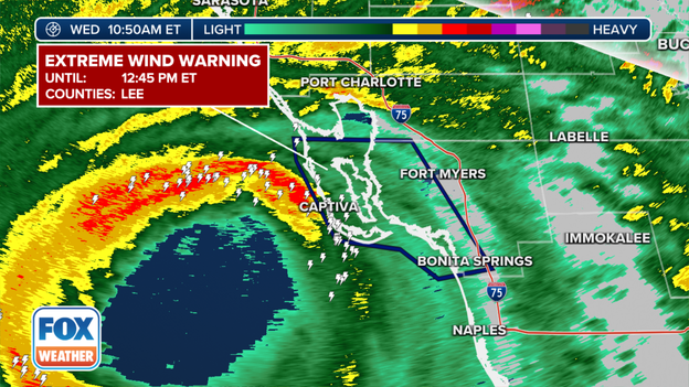
An Extreme Wind Warning is in effect in Lee County as the eyewall from hurricane Ian brushes the coast
The National Weather Service issued an Extreme Wind Warning as the eyewall of Hurricane Ian begins to brush the coast.
This includes the communities of: Cape Coral, Bonita Springs and Estero.
Charlotte County Emergency Management announced that it has suspended emergency response calls due to the hazardous conditions caused by Hurricane Ian.

Miami International Airport expects to remain open during Hurricane Ian
Miami International Airport communications director Greg Chin joined FOX Weather meteorologist Jason Frazer and explains that the airport is expected to remain open during Hurricane Ian.
However, passengers arriving in and departing MIA need to check with airlines directly to check the status of flights.
Power outages continue to jump in Florida as Hurricane Ian nears.
As predicted, power outages continue to rise in Florida as Hurricane Ian gets closer to the Sunshine State.
Hurricane Ian is now a Category 4 hurricane, and a catastrophic storm surge is expected along Florida's Gulf Coast.
FOX Weather meteorologists Jason Frazer and Amy Freeze break down the anatomy of a hurricane and explain the different categories of the Saffir-Simpson Scale to show us how dangerous a hurricane can be.
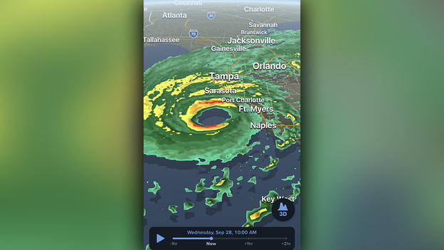
The FOX Weather 3D mobile radar tracks Hurricane Ian approaching the coast of Southwest Florida. (FOX Weather app)
Hurricane Ian remains a high-end Category 4 hurricane with maximum sustained winds of 155 mph.
The National Hurricane Center said hurricane-force winds (74-plus mph) are approaching the coast of Southwest Florida near Sanibel Island.
The Southwest Regional Airport in Fort Myers recently reported a wind gust of 62 mph.
The center of Hurricane Ian is currently located 60 miles west of Naples, Florida, or 65 miles southwest of Punta Gorda, Florida.
Power outages have jumped to 154,000 in Florida.
Power outages in Florida have been increasing all morning, and as of 10 a.m. that number has jumped again to 154,000.
Widespread power outages are expected as Hurricane Ian lashes Florida with strong wind and torrential rain.
There is an enhanced risk of tornados along Florida's Space Coast as severe weather associated with Hurricane Ian moves across the region.
A Tornado Watch is in effect until 5 p.m., but that could be extended.

As Hurricane Ian's winds howled across the island nation, the power began to falter across the capital city of Havana and streets emptied as most residents took refuge in anticipation of potential flooding and storm surge.
By Tuesday evening, Havana residents walked on the streets in complete darkness, illuminated only by the headlights of passing cars.
Check out this eerie drone video showing a deserted St. Petersburg, Florida, as Hurricane Ian approaches the area as a Category 4 hurricane.
Millions of Floridians have been told to evacuate the coast and other low-lying areas due to catastrophic storm surge and flooding due to the hurricane’s effect.
Check out these incredible photos from the National Weather Service in Tampa that shows water receding along the coast in Venice.
Water is expected to come rushing back as Hurricane Ian continues its approach to Florida, and officials are urging people to walk in any areas where water has receded.
FOX Weather is bringing you live video from locations across Florida as Hurricane Ian moves closer to the state.
Tampa police shared incredible images of water that has receded from Tampa Bay.
The photos were taken along Bayshore Boulevard.
"A clear sign that Hurricane Ian is drawing near," the department said.
Catastrophic storm surge is likely along Florida's Gulf Coast because of Hurricane Ian.
The best advice: If you’re being told to evacuate from Hurricane Ian, you should heed those warnings and stay safe.
If you opt to stay home during the storm, the article above has some hurricane safety tips that could help keep you safe.
FOX Weather meteorologist Britta Merwin explains how Hurricane Ian could produce catastrophic storm surge levels as high as 18 feet along some coastlines in Southwestern Florida.
Updated storm-surge forecast from the National Hurricane Center. (FOX Weather)
Hurricane Ian remains a high-end Category 4 hurricane with 155-mph winds as its center sits about 60 miles off the coast of Naples, Florida.
The National Hurricane Center has increased the storm-surge forecast along the Southwest Florida coast, where a 12- to 18-foot surge is now expected from Englewood to Bonita Beach, including Charlotte Harbor and the cities of Port Charlotte and Fort Myers.
This will be a catastrophic and life-threatening storm surge in these areas as Hurricane Ian slowly approaches the Florida Peninsula ahead of its expected landfall Wednesday afternoon.
FOX Weather Hurricane Specialist Bryan Norcross says about 50 miles of coastline from Fort Myers to north of Charlotte Harbor will be changed forever as Hurricane Ian bears down on the Sunshine State.
Forecasters warn of catastrophic storm surge and strong wind that will lead to widespread power outages.
National Weather Service Director Ken Graham said it was heart-wrenching to see such a massive hurricane, like Hurricane Ian, bear down on land.
“If you’re in its path, from along the coast and well inland, please stay safe,” he said.
Hurricane Ian is likely to produce a catastrophic storm surge as the hurricane makes landfall in Florida on Wednesday afternoon.
At least 100,000 power outages have been reported in Florida so far.
Hurricane Ian has already led to more than 100,000 power outages in Florida, and more are likely.
Most of the power outages are located in Collier County.
Hurricane Ian is having a major impact on airports and airlines as the monster storm inches closer to Florida.
Several airports, including Tampa International Airport and Orlando International Airport, have suspended or will suspend operations for the duration of Hurricane Ian.
Those airport closures and flight cancellations will likely have a ripple effect across the country.
The FOX Forecast Center is keeping a close eye on powerfully Hurricane Ian , which has maintained its Category 4 strength as of 8 a.m.
Forecasters warn of catastrophic storm surge, and strong winds that will likely lead to widespread power outages across Florida.
Hurricane Ian is about 55 miles west of Naples, Florida. (FOX Weather)
Hurricane Ian remains an extremely dangerous Category 4 storm as of the 8 a.m. Eastern time advisory from the National Hurricane Center. Maximum sustained winds were estimated at 155 mph, which means Ian is just 2 mph shy of becoming a Category 5 hurricane.
Ian is forecast to make landfall in Southwest Florida as a catastrophic hurricane on Wednesday afternoon with destructive winds, life-threatening storm surge, widespread flooding and isolated tornadoes across the Florida Peninsula.
Hurricane Ian is currently centered about 55 miles west of Naples, Florida, or 60 miles southwest of Punta Gorda, Florida.
The Florida Highway Patrol in Tampa said the Skyway Bridge is now closed to traffic in both directions due to the effects of Hurricane Ian and will remain closed until conditions improve.
Hurricane Ian rapidly intensified Wednesday morning and is now packing maximum sustained winds of 155 mph.
According to Colorado State University tropical scientist Phil Klotzbach, only four hurricanes on record have made landfall in the continental U.S. with maximum sustained winds of 155 mph or higher:
- Labor Day (1935): 185 mph
- Camille (1969): 175 mph
- Andrew (1992): 165 mph
- Michael (2018): 160 mph
In a Wednesday morning update to provide information on Hurricane Ian, Florida Gov. Ron DeSantis said it is no longer possible to safely evacuate several counties along Florida’s Gulf Coast, and it’s time to “hunker down” and wait for conditions to improve.
Florida Gov. Ron DeSantis is holding a news conference on Hurricane Ian as the storm continues to rapidly strengthen before making landfall in Florida on Wednesday afternoon.
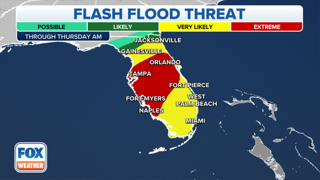
There is an extreme risk of flash flooding across central and southwestern Florida.
Torrential rain from Hurricane Ian is leading to an extreme risk of flash flooding across central and parts of southern Florida over the next day or so.
Orlando, Tampa, Fort Myers and Naples are all under the extreme risk of flash flooding.
Flash flooding is likely across the state.

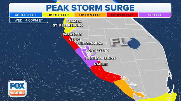
Peak storm-surge forecast along the Gulf Coast of Florida.
The National Hurricane Center has increased the storm-surge forecast along Florida's Gulf Coast ahead of a catastrophic strike from Hurricane Ian on Wednesday afternoon.
Peak storm-surge inundation as high as 16 feet above ground level is now predicted along the Southwest Florida coastline from Englewood to Bonita Beach, including Charlotte Harbor and the cities of Port Charlotte and Fort Myers.
The deepest water will occur along the immediate coast near and to the right of Hurricane Ian's center, where the surge will be accompanied by large waves.
The center of Hurricane Ian is just over 60 miles offshore from Southwest Florida. (FOX Weather)
Ian has rapidly intensified off the Gulf Coast of Florida on Wednesday morning and is only 2 mph away from becoming a Category 5 hurricane.
The current forecast from the National Hurricane Center suggests Ian will make landfall Wednesday afternoon between the Sarasota, Port Charlotte, Fort Myers and Naples areas as a catastrophic Category 4 hurricane.
As Ian moves across Florida Peninsula, the extremely dangerous major hurricane will pack threats of catastrophic winds and flooding, in addition to life-threatening storm surge in Southwest and West-Central Florida.
The National Hurricane Center issued a special update on Hurricane Ian and said winds have increased again to 155 mph.
This is an extremely dangerous situation, and catastrophic damage is expected along Florida’s Gulf Coast.
Impacts include strong wind, torrential rain, a life-threatening storm surge, flooding and widespread power outages.
Ian is only 2 mph away from becoming a Category 5 hurricane. (FOX Weather)
The Hurricane Hunters flying into Ian have found that the hurricane's winds have increased to 155 mph as it continues to intensify about 65 miles off the coast of the Florida Peninsula.
A Category 5 hurricane has winds of at least 157 mph, so Ian is only 2 mph away from reaching Category 5 strength on the Saffir-Simpson Hurricane Wind Scale.
The projected path and intensity of Hurricane Ian.
Hurricane Ian is forecast to make landfall Wednesday afternoon between the Sarasota, Port Charlotte, Fort Myers and Naples areas, likely as an extremely dangerous Category 4 hurricane.
As Ian moves onshore in the Florida Peninsula, the major hurricane will pack threats of catastrophic winds and flooding, in addition to life-threatening storm surge in Southwest and West-Central Florida.
After landfall, Ian is expected to slowly move across the Florida Peninsula and weaken to a tropical storm.
Ian is then predicted to emerge over the Atlantic waters late Thursday or early Friday before hooking back toward the Georgia and South Carolina coasts, where it could make a second landfall as a tropical storm Friday afternoon or evening.
The heavy rain and life-threatening flood threat associated with Ian will spread across the Florida Peninsula through Thursday and reach portions of the Southeast late this week and into the weekend.
Watch as water being pushed by Hurricane Ian rushes under a bridge in Marco Island, Florida .
A life-threatening storm surge is expected along Florida's Gulf Coast as the monster hurricane moves closer to the area.
Residents in Cape Coral, Florida, are being told to shelter in place as the effect of Hurricane Ian continue.
Emergency services have been suspended citywide, and will resume when winds are below 45 mph.
Hurricane Ian is lashing Florida with strong winds, and that's kicking up some large waves along the coast.
This video shows large waves crashing onshore in Key West, Florida.
Widespread power outages are expected across Florida due to Hurricane Ian
Widespread power outages are expected in Florida as Hurricane Ian continues on a path toward the state.
And while many of the outages will be caused by Hurricane Ian, some power companies shut off electricity ahead of the storm to avoid serious damage to underground equipment.
The center of Hurricane Ian is just over 50 miles offshore from Southwest Florida. (FOX Weather)
Hurricane Ian remains an extremely dangerous Category 4 hurricane with maximum sustained winds of 140 mph.
The center of Ian is currently located about 55 miles west-southwest of Naples, Florida, or 85 miles south-southwest of Punta Gorda, Florida.
A University of South Florida COMPS buoy located just to the north-northwest of Ian's eye recently measured a sustained wind of 66 mph and a wind gust to 94 mph.
On land, a WeatherFlow station near Sanibel Island recently measured a sustained wind of 39 mph and a wind gust to 55 mph.
Watch live as Hurricane Ian lashes Key West with torrential rain, strong winds and flooding.
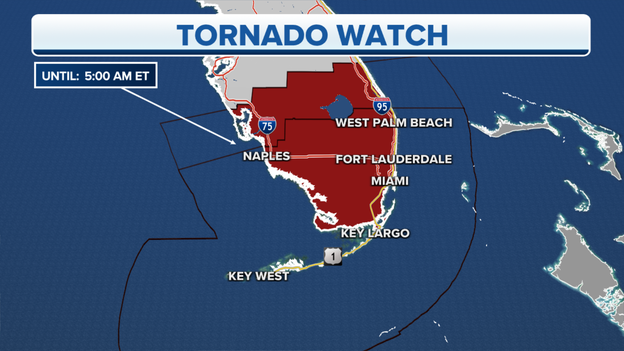
A Tornado Warning has been issued in central Palm Beach County until 6:30 a.m.
Locations included in the Tornado Warning are: West Palm Beach, Boynton Beach, Delray Beach, Palm Beach Gardens and Lake Worth.
FOX Weather correspondent Robert Ray is in Fort Myers Beach where he says conditions are deteriorating as powerful Hurricane Ian continues on a path toward Florida’s Gulf Coast.
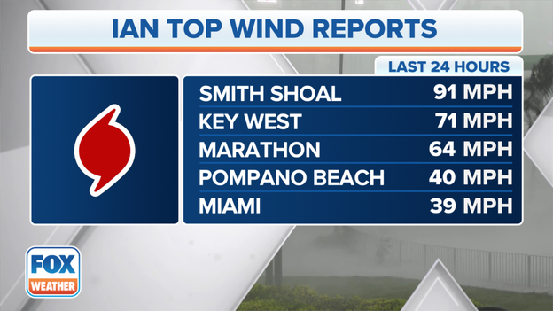
Top wind gust reports so far because of Hurricane Ian.
The FOX Forecast Center has been monitoring wind gusts reports as Hurricane Ian continues on a path toward Florida’s Gulf Coast.
So far, a wind gust of 91 mph was reported in Smith Shoal.
Key West had a 71 mph wind gust.
A Tornado Warning has been issued for Palm Beach Country in Florida until 5:45 a.m.
Locations impacted by the warning include Boca Raton, Wellington, Royal Palm Beach, Loxahatchee and Mission Bay.
A Tornado Watch remains in effect for most of central and southern Florida until 5 a.m. as Hurricane Ian inches closer to the state.
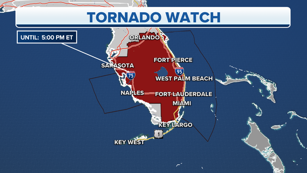
A Tornado Watch is in effect across central and southern Florida until 5 p.m.
Hurricane Ian is approaching Florida’s Gulf Coast, but the storm’s effects will be felt across the state.
A Tornado Watch is in effect until 5 p.m. for most of central and southern Florida including Orlando, Sarasota, Fort Pierce, West Palm Beach, Naples, Fort Lauderdale and Miami.
The National Hurricane Center says Hurricane Ian has intensified into an extremely dangerous Category 4 hurricane as it approaches Florida’s Gulf Coast.
Ian is now an extremely dangerous Category 4 hurricane. (FOX Weather)
The Hurricane Hunters have found that Ian has intensified into an extremely dangerous Category 4 hurricane with maximum sustained winds of 140 mph.
Hurricane Ian is currently located about 75 miles west-southwest of Naples, Florida, or 105 miles south-southwest of Punta Gorda, Florida.
Some fluctuations in intensity are possible before Hurricane Ian reaches Florida's Gulf Coast. However, Ian is expected to make landfall in Southwest or West-Central Florida later Wednesday as an extremely dangerous major hurricane. Weakening is then expected after landfall, but heavy rain will continue to pose a life-threatening threat of flooding as Ian moves inland.
Video shows Key West being battered with strong wind and flooding as Hurricane Ian moved near the region.
Hurricane Ian is just hours from making landfall along Florida's Gulf Coast.
Major impacts include torrential rain, strong wind and a life-threatening storm surge.
Hurricane Ian is less than 100 miles from the Florida Peninsula. Dozens of Tornado Warnings have already been issued across South Florida and a significant storm surge left parts of the Keys underwater.
Florida Tropical Weather Alerts
As of 2 A.M., Hurricane Ian was located less than 100 miles SW of Naples, Florida.
Maximum sustained winds remain around 120 mph, making the storm a dangerous Category 3.
A Hurricane Warning continues for Florida's west coast and areas of the central Peninsula. This includes coastal locations such as Tampa Bay, Sarasota, Fort Myers, Cape Coral, Punta Gorda, Naples, Everglades City and Orlando.
About 15 million people are covered by the Hurricane Warning.
A Tropical Storm Warning covers stretches from the Florida Keys into South Carolina, along the U.S. East Coast.
The hurricane is forecast to weaken slightly before landfall on Wednesday evening.
A storm surge of 4 feet was reported in the Florida Keys and numerous roadways were under water.
Tornado Watch
Hurricane Ian has produced a tornado outbreak in South Florida with at least nine reported twisters so far. The threat of supercells will continue through Wednesday for the Florida Peninsula.
At least one of the tornadoes is believed to have touched down in Broward County: See the damage.
A storm surge of over 4 feet produced significant flooding in Key West and the Lower Keys. Data sensors reported water levels reached their third highest stage on record.
Historical water levels: Hurricane Wilma (3.14') Hurricane Irma (2.69) Hurricane Ian: (2.46)
After significant flooding was spotted, the National Hurricane Center issued a Storm Surge Warning for the Lower Keys.
Tampa International Airport closed at 5 p.m. Tuesday as Hurricane Ian threatened. The airport was left nearly abandoned with only essential personnel allowed to stay.
America’s Weather Team is working through the night to keep you safe as the Category 3 hurricane bears down on Florida. Follow our reporters and meteorologists as they take you behind the scenes.
Download the FOX Weather app to track Hurricane Ian in 3D: Click Here
FOX Weather 3D Radar

Tracking Hurricane Ian
As of 12 A.M., Hurricane Ian was located near the Dry Tortugas or about 110 miles SW of Naples, Florida.
Maximum sustained winds remain around 120 mph, making the storm a dangerous Category 3.
A Hurricane Warning continues for Florida's west coast and areas of the central Peninsula. This includes coastal locations such as Tampa Bay, Sarasota, Fort Myers, Cape Coral, Punta Gorda, Naples and Everglades City.
About 15 million people are covered by the Hurricane Warning.
A Tropical Storm Warning covers stretches from the Florida Keys into South Carolina, along the U.S. East Coast.
The hurricane is forecast to weaken slightly before landfall on Wednesday evening.
An inundation level of more than 4 feet was reported in Key West on Tuesday evening.
Live coverage of Hurricane Ian from Tuesday, 09/27, is available by clicking here.
You’ve reached the beginning of this live coverage.