Record highs broken as winter warmth surge impacts millions across Southern Plains to Mid-Atlantic
Over 240 million Americans will experience fall-like temperatures in mid-winter this week, with more than 60 record highs at risk of being broken.

Unseasonable warmth surges across the South, expanding Eastward
Millions of Americans will experience temperatures 20 to 30 degrees above average this week, with 28 record highs already set on Sunday. This warm-up will bring increased moisture and expand Eastward to New York and even parts of New England.
Heat is on the rise once again, with more than 240 million Americans facing temperatures 20 to 30 degrees above average this week.
A strong ridge of high pressure over the Plains is expected to challenge more than 60 record-high temperatures as it pushes heat from the Southern Plains into the Southeast, Great Lakes and Mid-Atlantic by Friday.

High temperature departures through Thursday
(FOX Weather / FOX Weather)
As the high-pressure system pumps warmth over the Central Plains, higher temperatures will persist and become more widespread across the South and East by mid to late week, triggering possible record-breaking heat as millions will be above average.
Austin, Texas, has already seen one record high this year at 89 degrees on Friday, Jan. 2, and will be flirting with record highs again on Tuesday and Wednesday.
More than 60 record highs are expected, with 28 set on Sunday alone across much of the Southern Tier.

Record-high temperatures on Sunday
(FOX Weather / FOX Weather)
By Friday, even parts of the Great Lakes could see record-breaking heat, with Detroit potentially surpassing its current record of 55 degrees set nearly 80 years ago in 1949.
According to the FOX Forecast Center, high temperatures in the 50s are not only 15 to 20 degrees above average, but also over 30 degrees warmer than what we saw on New Year's Day. On Jan 1, highs struggled to reach the 20s and wind chills were in the teens and single digits.

New year, new travel alerts for millions across the country
Travel expert Jennifer Weatherhead joins FOX Weather to talk through how everyone can travel smarter in the new year.
Cities across the front range, like Denver, could also see record highs to end the weekend.
The Climate Prediction Center’s long-range outlook shows little change in the warming trend over the next six to 10 days across the central and eastern U.S.
Many Americans are all too familiar with this year’s weather whiplash pattern as repeated arctic blasts were followed by record-breaking heat for Christmas, and then by mounds of snow from a powerful lake-effect storm. There's no doubt the winter started out strong.
MAN DIES IN CALIFORNIA AFTER BEING SWEPT AWAY INTO CREEK DURING FLOODING, TORRENTIAL RAIN
We saw arctic air take hold all the way back in November, cold-stunning iguanas in Florida and by early December, around 180 million Americans experienced extreme cold, with some cities in the High Plains and Upper Midwest struggling to climb above freezing.

Iguanas typically begin to lose mobility when temperatures reach 50 degrees. Below that, the cold can completely immobilize them.
((Cristobal Herrera/South Florida Sun Sentinel/Tribune News Service via Getty Images) / Getty Images)
With that came record lows across the U.S. as well, with wind chills adding to the intensity of the cold.
Recently, a severe winter storm brought hurricane-force winds and heavy snow to the northern U.S., spawning travel and causing power outages to over 300,000 customers.
This was followed by a powerful lake-effect storm that brought heaps of snow across the Great Lakes region and broke snowfall records in Syracuse, New York, with accumulations over two feet.
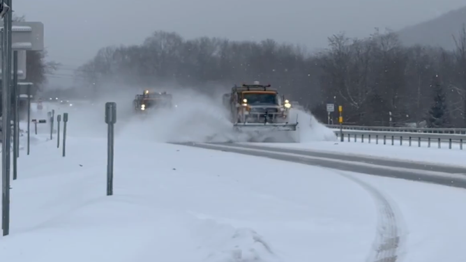
![Plows hard at work in Cattaraugus County, New York, clearing snow from roads on Dec. 30, 2025.]() Image 1 of 5
Image 1 of 5Plows hard at work in Cattaraugus County, New York, clearing snow from roads on Dec. 30, 2025. (@NYSDOTBuffalo/X)
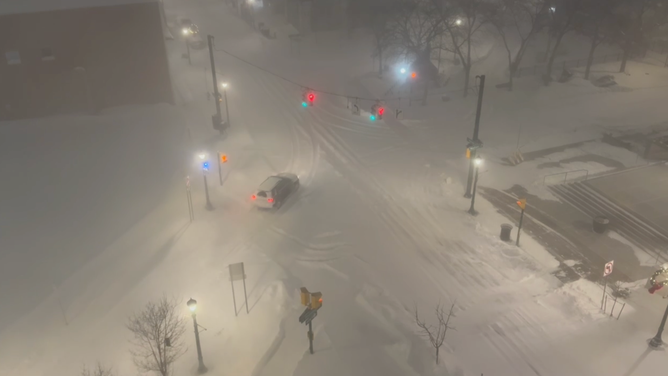
![Lake-effect snow creates whiteout conditions in Syracuse, NY on Tuesday, Dec. 30, 2025.]() Image 2 of 5
Image 2 of 5Lake-effect snow creates whiteout conditions in Syracuse, NY on Tuesday, Dec. 30, 2025. (Katie Byrne)
![A snowy road in Oswego, NY on Jan. 2, 2026.]() Image 3 of 5
Image 3 of 5A snowy road in Oswego, NY on Jan. 2, 2026. (Brandy Campbell)
![A measuring stick shows 28 inches of snow in Fair Haven, New York on Jan. 2, 2026.]() Image 4 of 5
Image 4 of 5A measuring stick shows 28 inches of snow in Fair Haven, New York on Jan. 2, 2026. (Brandy Campbell)
![A person treks through feet of snow in Fair Haven, NY on Jan. 2, 2026.]() Image 5 of 5
Image 5 of 5A person treks through feet of snow in Fair Haven, NY on Jan. 2, 2026. (Brandy Campbell)


But now that we’re transitioning to a warm-up, it will feel more like fall than the middle of winter this week.