Dangerous winter storm knocks out power to over 300,000 from hurricane-force winds, heavy snow
A major winter storm is sweeping through the Northern U.S., unleashing rain, snow, and hazardous winds, spawning travel disruptions and power outages, as Blizzard Warning are issued in Minnesota and Wisconsin.
Winter front threatens Northern Tier with dangerous winds, rain and snow
A post-holiday storm will bring heavy rain, snow and hazardous winds across the Northern tier. Blizzard Warnings have been posted for Minnesota and Wisconsin, as 250,000 customers nation wide have already lost power.
With millions of Americans traveling during the holiday week, winter weather could disrupt travel as a dangerous post-holiday storm sweeps across the Northern Tier, producing snow, ice, rain and intense winds with Blizzard Warnings posted for Minnesota and Wisconsin.
The storm will move today through Tuesday and while portions of the Northern Tier have already seen inches of snow and strong winds, the FOX Forecast Center says impacts will expand as the system tracks towards the Northeast today, followed by cooler air and lake-effect snow.
Hurricane-force wind gusts of 79 mph were reported in Buffalo on Monday, marking the highest since 1980 per the FOX Forecast Center.
Originating in the Midwest, a rapidly deepening low-pressure system will continue to swing through the region bringing rain, snow, gusty winds, and usher in colder air east. While accumulations will range from 5 to 8 inches, shifting winds across the northern Great Lakes will spark intense lake-effect snow, adding to totals that may be measured in feet.
The FOX Forecast Center says the storm’s rapid intensification will tighten the pressure gradient, generating powerful winds.
At least 50 cars and multiple semi-trucks were involved in a massive pile-up on Interstate 75 in Detroit, Michigan amid a dangerous winter storm on Monday.
The New York State Department of Transportation said the State of Emergency currently in effect has been expanded due to ongoing lake effect snow and high winds.
Transportation officials said hazardous travel and near whiteout conditions are expected for Western New York, the Finger Lakes, Central New York and North Country. People are being advised to avoid driving and work from home if possible.
Forecast models have come into agreement that the low will not undergo bombogenesis, which is when it becomes a bomb cyclone from a quick drop in pressure, as it passes over the relatively warmer waters of Lake Michigan.
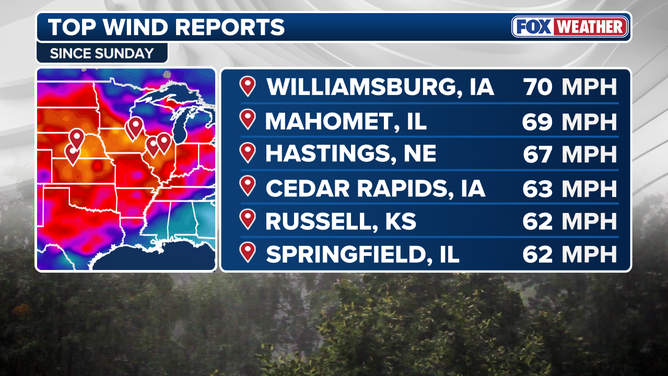
Top wind reports in the Midwest since Sunday Dec. 28
(FOX Weather / FOX Weather)
Winds have already been reported at over 60 mph across portions of the Plains and Upper Midwest and the intensity of the gusts has already caused over 350,000 customers nationwide to lose power, most notably in Michigan with just over 115,000 customers.
Extremely high winds resulted in the closure of the Bay Ridge ferry landing in New York City.
The powerful winds have begun wreaking havoc on travel too, with blizzard conditions in Iowa causing a pileup of over a dozen vehicles on I-35.
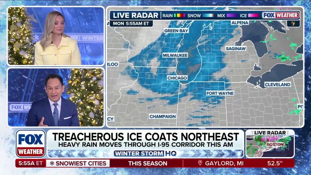
Ahead of the front, rain will spread across the Northeast today, as many areas, including the I-95 corridor, remain above freezing, limiting snow chances for the majority of the region. The exception will be northern New England and the higher terrain of the interior Northeast early this morning, where frozen precipitation is expected, but will quickly shift to rain.
![]() Image 1 of 4
Image 1 of 4People walk across the Bow Bridge in a snow-covered Central Park in New York City on December 27, 2025. New York City receieved around 4 inches (10 centimeters) of snow overnight. Airlines canceled 1,500 US flights during the peak holiday travel period Friday, with severe winter storm warnings and heavy snow forecast across parts of the Midwest and northeast. (Photo by TIMOTHY A. CLARY / AFP via Getty Images) (Photo by TIMOTHY A. CLARY / AFP via Getty Images)
![]() Image 2 of 4
Image 2 of 4People walk in the snow in Central Park in New York City on December 27, 2025. New York City receieved around 4 inches (10 centimeters) of snow overnight. Airlines canceled 1,500 US flights during the peak holiday travel period Friday, with severe winter storm warnings and heavy snow forecast across parts of the Midwest and northeast. (Photo by TIMOTHY A. CLARY / AFP via Getty Images) (Photo by TIMOTHY A. CLARY / AFP via Getty Images)
![]() Image 3 of 4
Image 3 of 4Post-Christmas Snow in Hampton Bays, New York (Heather King)
![]() Image 4 of 4
Image 4 of 4Children sled in a park in the Brooklyn borough of New York City on December 27, 2025. New York City receieved around 4 inches (10 centimeters) of snow overnight. Airlines canceled 1,500 US flights during the peak holiday travel period Friday, with severe winter storm warnings and heavy snow forecast across parts of the Midwest and northeast. (Photo by ANGELA WEISS / AFP via Getty Images) (Photo by ANGELA WEISS / AFP via Getty Images)


The FOX Forecast Center warns that icing appears likely where cold air remains trapped, which will create hazardous travel conditions throughout New England, particularly at higher elevations.
Winter Weather Alerts have been issued for most of the region, with ice accumulations of up to a quarter-inch possible.
Travel in the Buffalo area could become dangerous starting at 11am due to potential whiteout conditions. It is critical everyone stay off the roads and stay safe. https://t.co/uTIGcGt1Pl
— Governor Kathy Hochul (@GovKathyHochul) December 29, 2025
WHAT TO DO DURING A WINTER STORM POWER OUTAGE
Like the Midwest, the Northeast will also see a quick burst of high winds, with gusts up to 40 mph. Intense winds up to 60 mph in the Midwest, especially the southern Great Lakes and higher elevations of New England, could potentially lead to more power outages.
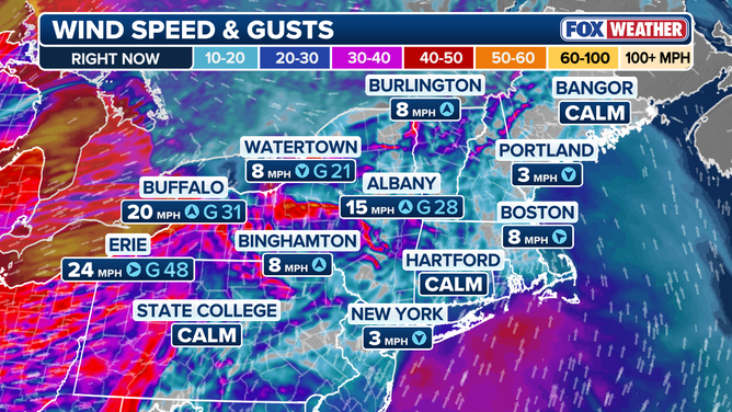
Wind gusts and speeds right now across the Northeast
(FOX Weather / FOX Weather)
Behind the front, a rush of cold air will arrive as winds pivot to the northwest, triggering significant lake-effect snow downwind of Lakes Erie and Ontario and portions of Western New York and the Tug Hill Plateau could potentially exceed a foot of accumulation through Tuesday.
Stay with FOX Weather for the latest up-to-date information on this major storm system as it tracks through the U.S.