What is lake-effect snow?
Learn the science behind this localized weather phenomenon that occurs most frequently in the Great Lakes.
FOX Weather Explains: What is lake-effect snow?
FOX Weather's Jason Frazer explains how lake-effect snow takes place.
Feet of snow, whiteout conditions, snow blowers and shovels – these are all commonly used terms when lake-effect snow pummels areas downwind of the Great Lakes during the late-fall and winter months.
Lake-effect snow develops when cold, dry air, often originating from Canada, flows across the relatively warmer waters of the Great Lakes.
As that cold air passes over the lakes, warmth and moisture from the water are picked up and transferred into the lowest portion of the Earth’s atmosphere. This rising air condenses into clouds, which can grow into narrow bands that are capable of producing snowfall rates on the order of 2 to 3 inches per hour or more, according to the National Weather Service.
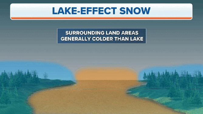
Lake-effect snow forms when cold air moves over warm water.
(FOX Weather)
Wind direction is an important factor in determining which areas will receive lake-effect snow. In many instances, heavy snow might be falling in one location while the sun is shining just a mile or two away.
The most intense bands of lake-effect snow generally develop when winds from the surface up through about 5,000 feet are well-aligned over the longest axis of the lake. For Lake Ontario, that would be winds blowing from the west, with heavy snow burying areas on the eastern end of the lake. But for Lake Michigan, that would be a northerly wind, producing heavy snow on the southern end of the lake.
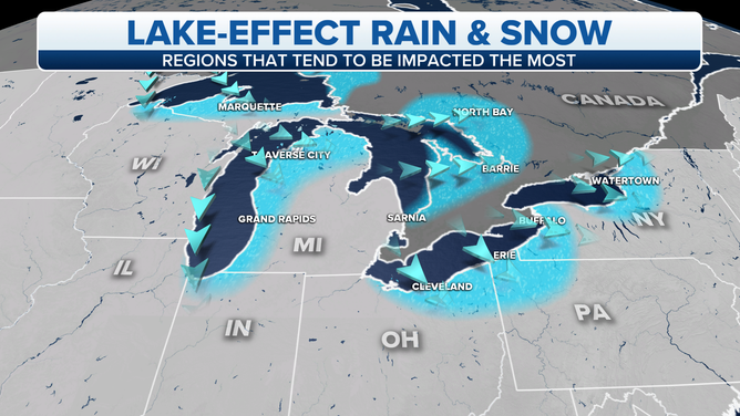
The blue-shaded regions tend to have the highest frequency of seeing lake-effect snow.
(FOX Weather)
Additionally, the greater the temperature difference between the air and the water, the stronger the lake-effect snowbands can become.
The general rule of thumb used by forecasters is that the temperature about 5,000 feet above the surface must be at least 23 degrees Fahrenheit (13 degrees Celsius) colder than the lake temperature for lake-effect snow to develop. If the temperature difference exceeds that, you’re more likely to see stronger, more organized snowbands.
WHEN CAN YOU EXPECT THE FIRST SNOW OF THE SEASON?
For example, if Lake Erie were 50 degrees, the overhead air mass would need to be 27 degrees or colder at 5,000 feet for Buffalo, New York, to have a risk for lake-effect snow (assuming other necessary ingredients were aligned, like a southwesterly wind over the longest axis of Lake Erie). If temperatures at that altitude were closer to 20 degrees, the lake-effect snow could develop into rather intense bands since the difference would be notably greater than 23 degrees.
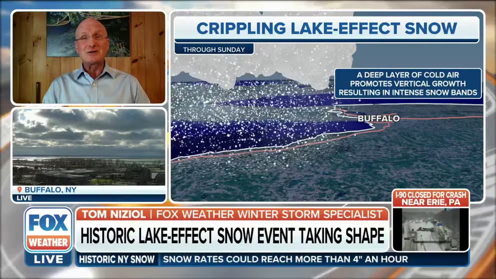
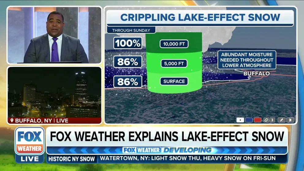
Why Buffalo can expect to see significant snowfall from 'crippling' snowstorm
FOX Weather winter storm specialist Tom Niziol explains why Buffalo will see significant snowfall from this historic snowstorm.
Once a lake freezes over, the source of warmth and moisture is lost, making it much more difficult for lake-effect snow to develop. Lake Ontario is the deepest Great Lake; thus, it does not completely freeze over late in the winter like some other lakes can. Therefore, lake-effect snow can remain a threat all winter downwind of Lake Ontario, unlike the other Great Lakes, which might freeze over by February (depending on how cold temperatures were earlier in the winter).
THESE ARE THE 7 SNOWIEST CITIES IN THE U.S.
Historic lake-effect snow in Buffalo in 2006
One of Buffalo’s most memorable lake-effect snowstorms actually occurred in the month of October.
Until 2006, the western New York city’s all-time monthly snowfall record for October was 6 inches, set back in 1909. But a heavy band of lake-effect snow buried the Buffalo area Oct. 12-13, 2006.
The storm, dubbed the "October surprise" by locals, caught many people off guard. Even though summer had just ended three weeks earlier, snow was falling at the rate of an inch or more per hour at times, according to the NWS.
Buffalo received 22.6 inches of snow in about 16 hours, with some areas picking up as much as 24 inches.
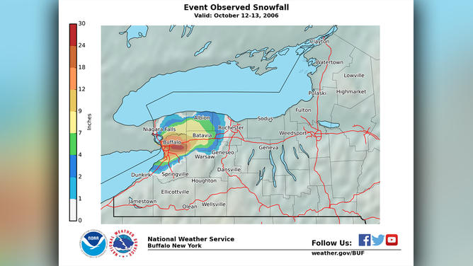
Observed snowfall during the "October surprise" snowstorm of Oct. 12-13, 2006, in western New York.
(National Weather Service)
In an event summary of this lake-effect snowstorm, the NWS office in Buffalo said it was a "dramatic, crippling out-of-season event" with "unprecedented meteorological parameters."
Trees and power lines were knocked down under the weight of heavy, wet snow, leaving almost a million customers in the area without power, some for as long as a week. Given it was only October, many trees still had their leaves, making them easier to topple over with snow able to stick to the leaves, adding increased weight. The NWS said there was already plenty of damage reported from just the first few inches of snow.
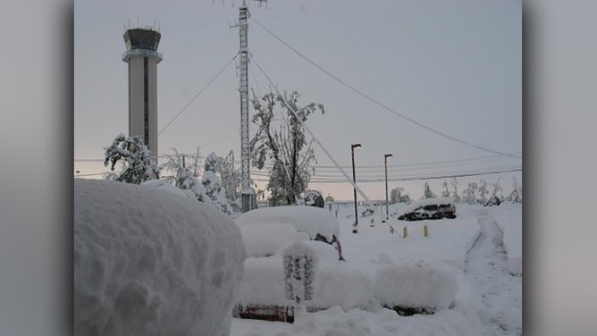
Two feet of snow on Oct. 12-13, 2006, produced this scene at the Buffalo, New York, National Weather Service office. Vehicles, trees and antennas were buried by the rare mid-October event.
(Tom Niziol / NWS Buffalo)
During the height of the storm, there was near-constant thunder and lightning for a good 12 hours, according to the NWS. This was the result of an unseasonably cold air mass passing over a still-warm, 62-degree Lake Erie, making environmental conditions extremely unstable.
7 WEATHER CHANGES TO EXPECT IN OCTOBER
Buffalo sees historic lake-effect snow again in 2014
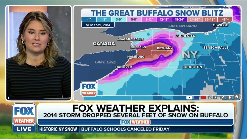
Eight years later, another historic lake-effect snowstorm – later coined "Snowvember" – struck the Buffalo area in November 2014.
More than 5 feet of snow crippled the Buffalo Southtowns, with South Cheektowaga tallying the most snowfall at 65 inches in just two days between Nov. 17-19, 2014.
THE BEST WAYS TO SHOVEL SNOW AND STAY SAFE DOING IT
Hundreds of roof collapses and structural failures were reported, thousands of drivers were stranded, and there were scattered food and gas shortages due to impassable roads. Numerous trees also fell due to the weight of the snow, causing isolated power outages where trees were toppled onto power lines.
A 132-mile stretch of the New York State Thruway was shut down for several days from Rochester, New York, to the Pennsylvania border. Other major routes, including Interstate 190, Interstate 290 and State Route 400, were also closed.
According to the NWS, this paralyzing lake-effect snowstorm was blamed for 14 deaths.
The Great Buffalo Snow Blitz in 2014 dropped historic amount of snow in Buffalo
The Great Buffalo Snow Blitz in 2014 dropped an historic amount of snow in Buffalo. FOX Weather's Jane Minar takes a look back at the historic lake-effect snow event.
Barely a day after that historic storm, another lake-effect snowstorm unfolded over the same area, dropping an additional 1 to 4 feet of snowfall.
Following the conclusion of the multi-storm event, snow totals peaked at 7 feet, with 3 to 4 feet of dense snowpack across the region by week's end.
A LOOK BACK ON BUFFALO'S HISTORIC 2014 ‘SNOWVEMBER’ STORMS THAT LEFT 7 FEET OF SNOW IN SOME SPOTS
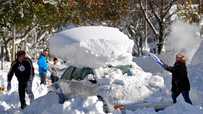
Michael Palmer and Carin Schultz work to clear her car of snow and remove it from Union street on Nov. 20, 2014, in the Buffalo suburb of Hamburg, New York.
(John Normile / Getty Images)
Lake-effect snow produced outside of the Great Lakes
It isn't just the Great Lakes that produce snow. The Great Salt Lake in Utah is another common area where lake-effect snow develops in the late-fall and winter months, occasionally bringing bands of snow into the Salt Lake City area.
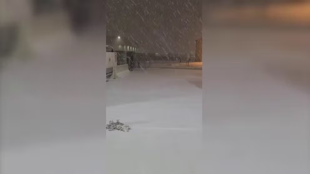
Lake-effect snow falls across Salt Lake City
Watch as lake-effect snow from Utah's Great Salt Lake creates a wintry scene around the Salt Lake City area.
There’s also ocean-effect snow, which forms the same way as lake-effect snow (except the ocean provides warmth and moisture instead of a lake). Southeastern Massachusetts, especially Cape Cod, is an area that can receive ocean-effect snow when all the necessary ingredients are aligned. It can also form off the Chesapeake Bay and, on rare occasions, parts of Florida's east coast (though it would most likely be ocean-effect rain there).
In the Eastern Hemisphere, sea-effect snowbands can develop in the fall and winter off the Sea of Japan and dump heavy snow along the country's western coast.