A look back on Buffalo's historic 2014 'Snowvember' storms that left 7 feet of snow in some spots
The snowstorms of Nov. 17-20, 2014, later dubbed "Snowvember," were a one-two punch of storms that had some areas just south of Buffalo digging out from 5-7 feet of snow, while some areas a few miles away received just a few inches of snow.
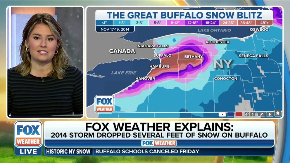
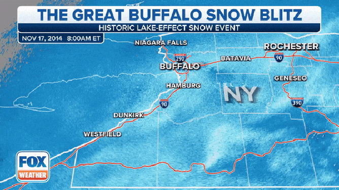
The Great Buffalo Snow Blitz in 2014 dropped historic amount of snow in Buffalo
The Great Buffalo Snow Blitz in 2014 dropped an historic amount of snow in Buffalo. FOX Weather's Jane Minar takes a look back at the historic lake-effect snow event.
BUFFALO, N.Y. – A multi-day, lake-effect snowstorm threatening Buffalo and surrounding areas this weekend is happening on the eighth anniversary of one of the greatest snow events in the region's history.
The snowstorms of Nov. 17-20, 2014, later dubbed "Snowvember" or the Buffalo "Snow Blitz" were a one-two punch of storms that had some areas just south of Buffalo digging out from 5-7 feet of snow, while some areas a few miles away received just a few inches.
'CRIPPLING' LAKE-EFFECT SNOWSTORM EXPECTED TO BURY BUFFALO, NEW YORK, IN UP TO 4 FEET OF SNOW
"The epic November 17-19th 2014 lake effect event will be remembered as one of the most significant winter events in Buffalo's snowy history," the National Weather Service office in Buffalo wrote, referencing the dates of the first storm.
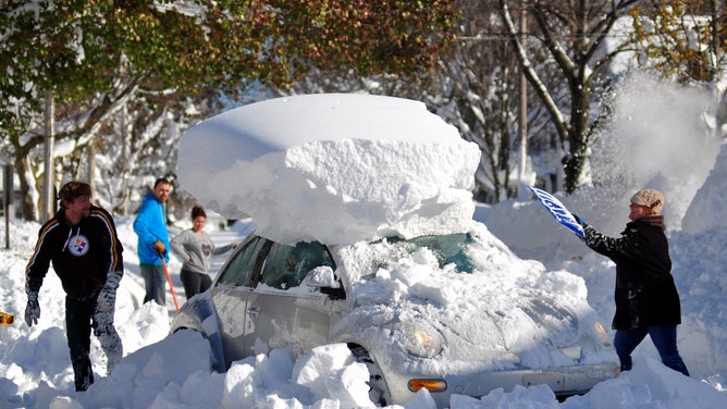
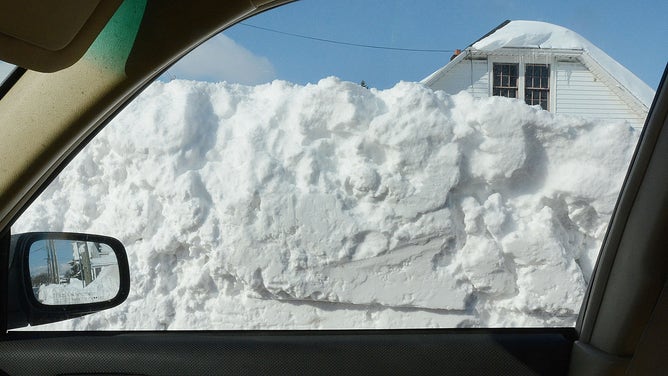
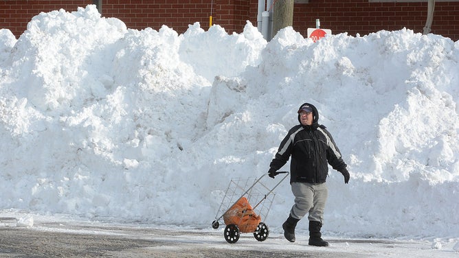
The storm was blamed for 14 deaths, hundreds of collapsed roofs and other structural damage, and left thousands of drivers suddenly stranded on impassable roads as heavy snow piled up in minutes -- with snowfall rates reaching as much as 3-6 inches per hour. Power outages spread across the region as trees succumbed to the weight of the snow, toppling into power lines.
![]() Image 1 of 24
Image 1 of 24BUFFALO, NY - NOVEMBER 21: Michael Palmer and Carin Schultz work to clear her car of snow and remove it from Union street on November 20, 2014 in the suburb of Hamburg, Buffalo, New York. The record setting Lake effect snowstorm dumped up to six feet of snow in less than 24 hours closing a one hundred mile section of The New York State Thruway as well as other major roads around Buffalo. Twelve deaths have already been attributed to the storm and with warming temperatures and rainfall in the forecast epic flooding is expected. (Photo by John Normile/Getty Images) ( )
![]() Image 2 of 24
Image 2 of 24BUFFALO, NY, UNITED STATES - NOVEMBER 21: Roadside Snow view from a car on November 21, 2014 in Buffalo, New York as the death toll attributed to Buffalo snow rises to 14. A brutal blast of Arctic air triggered a lake-effect storm and snow in the states of New York, Ohio, Michigan, Wisconsin and Pennsylvania. (Photo by Patrick McPartland/Anadolu Agency/Getty Images) ( )
![]() Image 3 of 24
Image 3 of 24BUFFALO, NY, UNITED STATES - NOVEMBER 21: A roadside snow view on November 21, 2014 in Buffalo, New York as the death toll attributed to Buffalo snow rises to 14. A brutal blast of Arctic air triggered a lake-effect storm and snow in the states of New York, Ohio, Michigan, Wisconsin and Pennsylvania. (Photo by Patrick McPartland/Anadolu Agency/Getty Images) ( )
![]() Image 4 of 24
Image 4 of 24BUFFALO, NY - NOVEMBER 19, 2014: Drew Ahmed makes his way through nearly five feet of snow on November 19, 2014 in the Lakeview neighborhood of Buffalo, New York. The record setting Lake effect snowstorm dumped up to six feet of snow in less than 24 hours closing a one hundred mile section of The New York State Thruway as well as other major roads around Buffalo. Four deaths have already been attributed to the storm and a second round beginning late Wednesday evening will bring up to three more feet of snow overnight. (Photo by John Normile/Getty Images) ( )
![]() Image 5 of 24
Image 5 of 24BUFFALO, NY, UNITED STATES - NOVEMBER 21: A resident passes near roadside snow on November 21, 2014 in Buffalo, New York as the death toll attributed to Buffalo snow rises to 14. A brutal blast of Arctic air triggered a lake-effect storm and snow in the states of New York, Ohio, Michigan, Wisconsin and Pennsylvania. (Photo by Patrick McPartland/Anadolu Agency/Getty Images) ( )
![]() Image 6 of 24
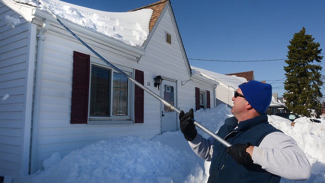
Image 6 of 24BUFFALO, NY, UNITED STATES - NOVEMBER 21: A residents work to remove snow from the roof on November 21, 2014 in Buffalo, New York as the death toll attributed to Buffalo snow rises to 14. A brutal blast of Arctic air triggered a lake-effect storm and snow in the states of New York, Ohio, Michigan, Wisconsin and Pennsylvania. (Photo by Patrick McPartland/Anadolu Agency/Getty Images) ( )
![]() Image 7 of 24
Image 7 of 24BUFFALO, NY - NOVEMBER 21: Abandoned cars wait to recovered at gas station on November 20, 2014 in the suburb of Blasdell, Buffalo, New York. The record setting Lake effect snowstorm dumped up to six feet of snow in less than 24 hours closing a one hundred mile section of The New York State Thruway as well as other major roads around Buffalo. Twelve deaths have already been attributed to the storm and with warming temperatures and rainfall in the forecast epic flooding is expected. (Photo by John Normile/Getty Images) ( )
![]() Image 8 of 24
Image 8 of 24BUFFALO, NY - NOVEMBER 21: Greg Mitri shovels snow from his roofe in the Buffalo, New York suburb of Lakeview November 20, 2014. The record setting Lake effect snowstorm dumped up to six feet of snow in less than 24 hours closing a one hundred mile section of The New York State Thruway as well as other major roads around Buffalo. Twelve deaths have already been attributed to the storm and with warming temperatures and rainfall in the forecast epic flooding is expected. (Photo by John Normile/Getty Images) ( )
![]() Image 9 of 24
Image 9 of 24BUFFALO, NY - NOVEMBER 21: A car waits to be recovered along Milestrip Road on November 20, 2014 in the suburb of Blasdell, Buffalo, New York. The record setting Lake effect snowstorm dumped up to six feet of snow in less than 24 hours closing a one hundred mile section of The New York State Thruway as well as other major roads around Buffalo. Twelve deaths have already been attributed to the storm and with warming temperatures and rainfall in the forecast epic flooding is expected. (Photo by John Normile/Getty Images) ( )
![]() Image 10 of 24
Image 10 of 24BUFFALO, NY - NOVEMBER 21: Residents take to the street for supplies along Lake Avenue on November 20, 2014 in the suburb of Blasdell, Buffalo, New York. The record setting Lake effect snowstorm dumped up to six feet of snow in less than 24 hours closing a one hundred mile section of The New York State Thruway as well as other major roads around Buffalo. Twelve deaths have already been attributed to the storm and with warming temperatures and rainfall in the forecast epic flooding is expected. (Photo by John Normile/Getty Images) ( )
![]() Image 11 of 24
Image 11 of 24BUFFALO, NY - NOVEMBER 20: Sydney, a six year old Golden retriever, makes her way through five feet of snow from a driveway on November 20, 2014 in the suburb of Lakeview, Buffalo, New York. The record setting Lake effect snowstorm dumped up to six feet of snow in less than 24 hours closing a one hundred mile section of The New York State Thruway as well as other major roads around Buffalo. Seven deaths have already been attributed to the storm and a second round beginning late Wednesday evening will bring up to three more feet of snow overnight and into Thursday. (Photo by John Normile/Getty Images) ( )
![]() Image 12 of 24
Image 12 of 24BUFFALO, NY, UNITED STATES - NOVEMBER 21: A resident works to clear snow on a roadside on November 21, 2014 in Buffalo, New York as the death toll attributed to Buffalo snow rises to 14. A brutal blast of Arctic air triggered a lake-effect storm and snow in the states of New York, Ohio, Michigan, Wisconsin and Pennsylvania. (Photo by Patrick McPartland/Anadolu Agency/Getty Images) ( )
![]() Image 13 of 24
Image 13 of 24BUFFALO, NY, UNITED STATES - NOVEMBER 21: A resident tries to reach her workplace among roadside snow on November 21, 2014 in Buffalo, New York as the death toll attributed to Buffalo snow rises to 14. A brutal blast of Arctic air triggered a lake-effect storm and snow in the states of New York, Ohio, Michigan, Wisconsin and Pennsylvania. (Photo by Patrick McPartland/Anadolu Agency/Getty Images) ( )
![]() Image 14 of 24
Image 14 of 24BUFFALO, NY, UNITED STATES - NOVEMBER 21: A car on a snowy road on November 21, 2014 in Buffalo, New York as the death toll attributed to Buffalo snow rises to 14. A brutal blast of Arctic air triggered a lake-effect storm and snow in the states of New York, Ohio, Michigan, Wisconsin and Pennsylvania. (Photo by Patrick McPartland/Anadolu Agency/Getty Images) ( )
![]() Image 15 of 24
Image 15 of 24BUFFALO, NY, UNITED STATES - NOVEMBER 21: A resident works to remove snow from the roof on November 21, 2014 in Buffalo, New York as the death toll attributed to Buffalo snow rises to 14. A brutal blast of Arctic air triggered a lake-effect storm and snow in the states of New York, Ohio, Michigan, Wisconsin and Pennsylvania. (Photo by Patrick McPartland/Anadolu Agency/Getty Images) ( )
![]() Image 16 of 24
Image 16 of 24BUFFALO, NY, UNITED STATES - NOVEMBER 22: A resident works to remove snow from the roof on November 22, 2014 in Buffalo, New York. (Photo by Patrick McPartland/Anadolu Agency/Getty Images) ( )
![]() Image 17 of 24
Image 17 of 24BUFFALO, NY, UNITED STATES - NOVEMBER 22: A high loader works to clear snow along an avenue on November 22, 2014 in Buffalo, New York. (Photo by Patrick McPartland/Anadolu Agency/Getty Images) ( )
![]() Image 18 of 24
Image 18 of 24BUFFALO, NY, UNITED STATES - NOVEMBER 22: A high loader works to clear snow along an avenue on November 22, 2014 in Buffalo, New York. (Photo by Patrick McPartland/Anadolu Agency/Getty Images) ( )
![]() Image 19 of 24
Image 19 of 24BUFFALO, NY - NOVEMBER 19, 2014: Drew Ahmed makes his way through nearly five feet of snow on November 19, 2014 in the Lakeview neighborhood of Buffalo, New York. The record setting Lake effect snowstorm dumped up to six feet of snow in less than 24 hours closing a one hundred mile section of The New York State Thruway as well as other major roads around Buffalo. Four deaths have already been attributed to the storm and a second round beginning late Wednesday evening will bring up to three more feet of snow overnight. (Photo by John Normile/Getty Images) ( )
![]() Image 20 of 24
Image 20 of 24BUFFALO, NY - NOVEMBER 20: Norbert Schnorr attempts to remove some of the five feet of snow from a driveway on November 20, 2014 in the suburb of Lakeview, Buffalo, New York. The record setting Lake effect snowstorm dumped up to six feet of snow in less than 24 hours closing a one hundred mile section of The New York State Thruway as well as other major roads around Buffalo. Seven deaths have already been attributed to the storm and a second round beginning late Wednesday evening will bring up to three more feet of snow overnight and into Thursday. (Photo by John Normile/Getty Images) ( )
![]() Image 21 of 24
Image 21 of 24BUFFALO, NY, UNITED STATES - NOVEMBER 21: A resident works to clear snow on a roadside on November 21, 2014 in Buffalo, New York as the death toll attributed to Buffalo snow rises to 14. A brutal blast of Arctic air triggered a lake-effect storm and snow in the states of New York, Ohio, Michigan, Wisconsin and Pennsylvania. (Photo by Patrick McPartland/Anadolu Agency/Getty Images) ( )
![]() Image 22 of 24
Image 22 of 24BUFFALO, NY, UNITED STATES - NOVEMBER 21: Workers try to clear snow in front of a building on November 21, 2014 in Buffalo, New York as the death toll attributed to Buffalo snow rises to 14. A brutal blast of Arctic air triggered a lake-effect storm and snow in the states of New York, Ohio, Michigan, Wisconsin and Pennsylvania. (Photo by Patrick McPartland/Anadolu Agency/Getty Images) ( )
![]() Image 23 of 24
Image 23 of 24BUFFALO, NY, UNITED STATES - NOVEMBER 21: A resident works to clear snow in front of his workplace on November 21, 2014 in Buffalo, New York as the death toll attributed to Buffalo snow rises to 14. A brutal blast of Arctic air triggered a lake-effect storm and snow in the states of New York, Ohio, Michigan, Wisconsin and Pennsylvania. (Photo by Patrick McPartland/Anadolu Agency/Getty Images) ( )
![]() Image 24 of 24
Image 24 of 24BUFFALO, NY, UNITED STATES - NOVEMBER 21: Workers try to clear snow in front of a building on November 21, 2014 in Buffalo, New York as the death toll attributed to Buffalo snow rises to 14. A brutal blast of Arctic air triggered a lake-effect storm and snow in the states of New York, Ohio, Michigan, Wisconsin and Pennsylvania. (Photo by Patrick McPartland/Anadolu Agency/Getty Images) ( )


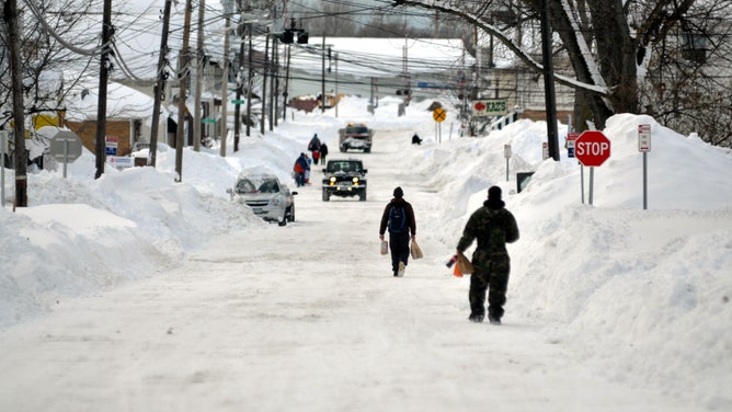


The first storm was enough to cripple the region. Snow began falling around Buffalo on the evening of Nov. 17, with even some thundersnow tossed in for extra drama. The 15-to-20-mile band of snow drifted north and south across Buffalo before settling in on the southern side of town, with snow rates reaching 3 inches per hour -- though some areas had periods of snowfall rates reaching 6 inches per hour, according to the NWS.
As the sun dawned on the 18th, about 12 hours later, areas within the snow band already had 1-3 feet of snow, with the heaviest snowfall on the northern edge of the band.
With some snow plows stuck and those free focused on plowing a few main roads for emergency vehicles, travel became nearly impossible. A 132-mile stretch of Interstate 90, known as the New York State Thruway, was closed from Rochester to the Pennsylvania border. Several other highways were shut down.
Radar loop of "Snowvember" storm of 2014.
(FOX Weather)
Meanwhile, farther north, a second band of lake-effect snow off Lake Ontario brought blizzard conditions Monday night into Tuesday with 1-2 feet of snow combined with 40-55 mph winds around Watertown.
Heavy snow continued inside the band for all of Tuesday, with 35-mph wind near Buffalo and snow totals reaching 4-5 feet by the end of the day. Residents described a sharp edge to the snow, with whiteout conditions inside the band but blue skies and hardly any snow outside the band.
"That intense band of snow we did see south of the metro area – it was so striking that north of the band there was blue sky, but people would see the north band and call it a ‘wall of snow’," said FOX Weather Meteorologist Jane Minar.
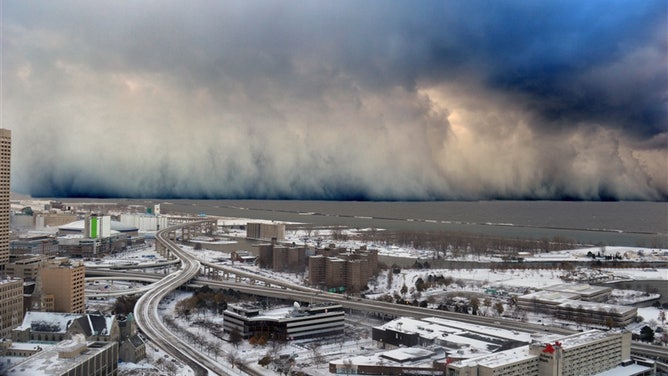
A wall of intense snowfall descending on the Buffalo Southtowns during the firstof two historic back-to-back lake-effect snow events in November 2014.
(Shawn Smith via NOAA / NOAA)
The National Weather Service described one street as having several feet of snow in one location but just a few inches on the ground 2 miles to the north.
If you look at Buffalo's all-time record snows, 2014 is strangely missing from the list because Buffalo's airport – the official measuring station – received just 6.2 inches through the event. Lancaster – just 4 miles away – received 63 inches.

(FOX Weather)
Finally, the band let up Wednesday morning as it drifted to the north and rapidly weakened.
There was no rest for the weary, as a second lake-effect event late on Nov. 19 and into Nov. 20 dropped another 1-4 feet of snow over nearly the same area and compounded rescue and recovery efforts, according to the NWS.
WHAT ARE SNOW SQUALLS AND WHY ARE THEY SO DANGEROUS?
"Storm totals from the two storms peaked at nearly 7 feet, with many areas buried under 3-4 feet of dense snowpack by the end of the event," the NWS wrote.
Hopes for snow to melt went too far in the other direction. Four days after the event, the temperature in Buffalo soared, reaching 65 degrees, according to NOAA. The warm temperatures were accompanied by rain, causing a significant amount of the snow to melt rapidly, resulting in widespread flooding in the region.
Despite the massive overall impacts, meteorologists said the event was well forecast. A Lake-Effect Snow Watch went into effect 56 hours before the snow began, with a warning issued more than a day in advance with forecast snow totals of 2-3 feet amid potential snowfall rates of 3-5 inches per hour.