7 weather changes to expect in October
From decreasing daylight and temperatures to first freezes and snowfalls, there are several notable weather changes that happen during October.
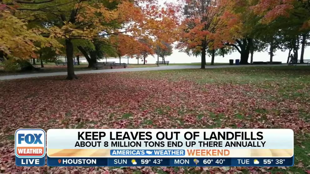
Why experts are urging homeowners to skip bagging up all those leaves this fall
Professor and extension specialist Susan Barton joined FOX Weather on Sunday morning to explain why it’s better to chop up leaves and leave them in your yard rather than bagging them up and throwing them in the trash.
Fall is the transition season between summer and winter, so it should be no surprise that October can be a month full of shifts in the weather.
Here are seven weather changes to expect during the so-called spooky season.
1. Decreasing daylight
The amount of daylight quickly grows shorter as October progresses, with the fastest decrease at the beginning of the month. Many cities lose 2-3 minutes of daylight each day, leading to later sunrises and earlier sunsets.
New York City loses an hour and 17 minutes of daylight between the first and last day of the month, while Seattle finishes October with an hour and 38 minutes less daylight than when the month began.
For some, the last 7 p.m. sunset of the year occurs in October, ushering in a five-month period during which the sun goes down before 7 p.m.
HOW TO WATCH FOX WEATHER ON TV
Fall season headlines.
(FOX Weather)
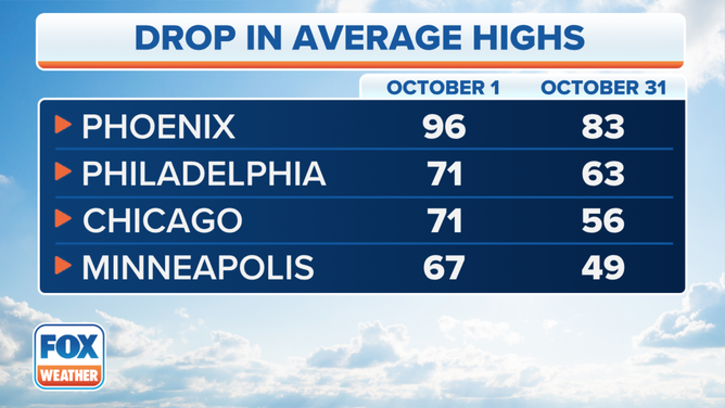
2. Decreasing temperatures
Average temperatures quickly decrease during October because of the shorter days and longer nights.
In Philadelphia, the average high drops from 71 degrees on Oct. 1 to 63 degrees by Halloween. Chicago's average high falls from 71 degrees to 56 degrees between the first and last day of the month.
Cities such as Miami and Phoenix that are at more southern latitudes stay warm with temperatures in the 80s and even 90s.
NORTHEAST, MID-ATLANTIC THE ONLY AREAS FORECAST TO HAVE COOLER-THAN-AVERAGE OCTOBER
Average high temperature drops during October.
(FOX Weather)
3. First freeze of the season
Along with October's lower temperatures come the first frosts and freezes of the season.
The higher elevations of the West and areas along the Canadian border often have their first freeze before October begins, but the season's first 32-degree temperature typically occurs in October for a large portion of the U.S.
This includes much of the Northeast, Midwest, mid-South and the northern and central Plains. October is also when the first freeze usually occurs in much of Oklahoma and the Texas Panhandle, New Mexico and northeastern Arizona.
States along the Gulf Coast are some of the only areas of the country where the first freeze does not happen in October, on average.
HERE'S WHEN TO EXPECT THE FIRST FREEZE OF THE SEASON
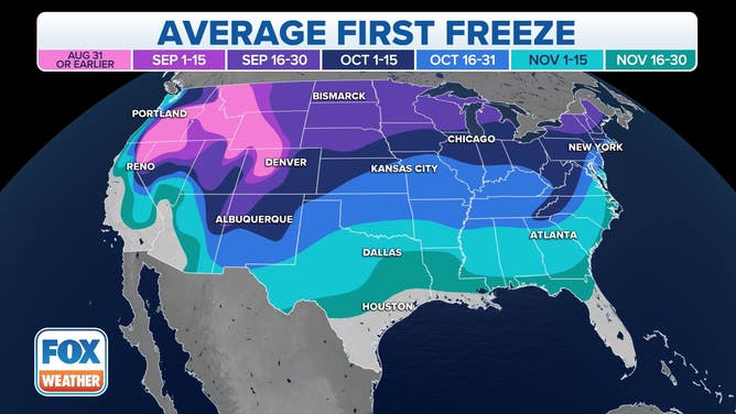
Average date of the first freeze of the season.
(FOX Weather)
4. First snow of the season
The first snow of the season can also accompany October's chilly temperatures.
While the higher elevations in the Rockies and northern High Plains can see snow in September or even August, many areas of the U.S. receive their first snowfall during October in an average year.
The season's first snow usually falls in October in parts of the Four Corners, central Plains, Upper Midwest, Great Lakes and interior Northeast.
The first snowfall for the Interstate 95 corridor usually happens after Halloween.
WHEN CAN YOU EXPECT THE FIRST SNOW OF THE SEASON?
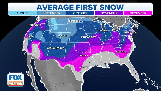
Average date of the first snowfall of the season.
(FOX Weather)
5. Late-season tropical threats along the East and Gulf coasts
Tropical activity gradually starts to wane in October, but it can still be an active month for tropical storms and hurricanes, especially at the beginning of the month.
October ranks as the third-most-active month (behind September and August) for tropical activity in the Atlantic Basin, typically producing two named storms each year, one of which becomes a hurricane. Every other October, on average, one of those hurricanes intensifies into a "major hurricane," achieving Category 3 or higher intensity on the Saffir-Simpson Hurricane Wind Scale.
While most areas of the Atlantic Basin remain open for development in October, a lot of the tropical activity tends to shift westward as the disturbances that frequently roll off Africa during the peak of hurricane season start to fade away. Any disturbances that do emerge off the coast of Africa in October will often run into hostile atmospheric conditions, such as dry air and strong upper-level winds over the waters of the eastern tropical Atlantic.
In October, we actually look closer to home for the best chances of tropical development.
The western Caribbean Sea, the eastern Gulf of Mexico and the western and central Atlantic Ocean are the areas where you'll most likely find a tropical storm or hurricane in October. That means parts of the East and Gulf coasts of the U.S. remain at risk of a landfalling storm to occur.
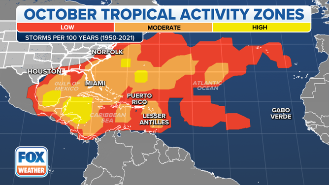
This map shows where tropical cyclone activity tends to occur during October. The data are shown as the combined number of tropical depressions, tropical storms and hurricanes whose centers pass within 125 miles of a point on the map during a 100-year period. The analysis is based on data from the 72-year period from 1950 to 2021 but normalized to 100 years.
(FOX Weather)
Between 1950 and 2022, the U.S. was impacted by 20 landfalling hurricanes during the month of October, according to NOAA's Hurricane Research Division. Of course, that doesn't include Superstorm Sandy since the former hurricane had lost its tropical characteristics before making landfall near Atlantic City, New Jersey, on Oct. 29, 2012.
More hurricanes have impacted South Florida in October than any other month. Through 2022, 26 October hurricanes had passed within 100 nautical miles of Miami since recordkeeping began in 1851, according to NOAA's historical hurricane tracks.
ATLANTIC HURRICANE SEASON CAN REMAIN ACTIVE IN OCTOBER WITH POTENTIAL U.S. THREATS
6. Peak of fall foliage
Most of the U.S. reaches the peak of fall foliage in October, with leaves turning brilliant shades of yellow, red and orange.
While the date of the peak fall foliage season can vary by year, it usually falls within a few weeks of past fall foliage peaks.
Fall foliage typically peaks in early October along the northern tier of the country, as well as in northern New York, Vermont, New Hampshire and Maine.

Watch: Drone footage shows spectacular fall foliage in Vermont
Drove video taken above the Vermont landscape shows stunning images of trees with red, orange and yellow leaves as fall foliage season gets underway.
In the Midwest, Northeast and the rest of New England, the fall foliage usually peaks in mid- to late October.
Mid-November is considered to be one of the latest dates to see significant changes in the colors of the leaves. In the map below, areas outside the colored zones do not usually have a significant amount of trees that lead to brilliant red, orange and yellow colors.
FALL FOLIAGE TRACKER: DISCOVER MAPS AND WHERE TO SEE THE MOST BRILLIANT COLORS ACROSS THE U.S.
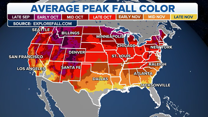
Average peak fall color
(FOX Weather)
7. Santa Ana winds return to California, increasing wildfire concerns
Normally, winds along the California coastline blow inland from the ocean. This is what gives that region such pleasant climates most of the year.
During a Santa Ana wind event, the wind pattern shifts offshore and brings in hot, dry air from the east side of mountain ranges that border the coast.
Fall is when these Santa Ana winds typically become more common in California. This is the time of year when a strong high-pressure system frequently parks itself over the Great Basin, while a complimentary low-pressure system sets up off the California coast.
Since the atmosphere prefers to be balanced, the air rushes quickly from the area of high pressure to the area of low pressure, resulting in offshore Santa Ana winds over California.

Strongest Santa Ana winds of the year so far blow across Southern California
The Santa Ana winds are blowing across Southern California this week, increasing the risk of rapidly spreading wildfires.
"They typically commence in, you know, late September, October, right, and then they go throughout the winter," said John Abatzoglou, an associate professor of climatology at the University of California Merced.
While there is no direct connection between Santa Ana winds and wildfires, they can increase the risk of wind-driven fires in parts of California.
WHY DRY THUNDERSTORMS POSE WILDFIRE, DUST STORM RISKS
Following the summer dry season, soils are generally driest in the early fall, providing plenty of fuel for potential wildfires. If Santa Ana winds come at the right time, they can spread an existing wildfire out of control or turn a newly developed small brush fire into an inferno.
"When we move into September, October, November, that's when we begin to worry about the wind-driven fire season in these coastal environments," Abatzoglou said.
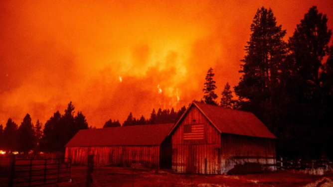
TOPSHOT - Flames rip across a hillside behind a building donning an American flag as the Caldor fire pushes into South Lake Tahoe, California on August 30, 2021. At least 650 structures have burned and thousands more are threatened as the Caldor fire moves into the resort community of South Lake Tahoe, California. Thousands of people were ordered to evacuate Monday as a huge wildfire loomed over a major US tourist spot, filling the air with choking smoke. The Caldor Fire has already torn through more than 270 square miles (700 square kilometers), razing hundreds of buildings.
(JOSH EDELSON / AFP / Getty Images)