Superstorm Sandy 10-year anniversary: Why the 2012 superstorm was so destructive in the Northeast
The New York City tri-state area and the Jersey Shore were struck by the core of Sandy, but the superstorm’s effects extended thousands of miles away from its center. Heavy snow buried the mountains of West Virginia as severe thunderstorms stretched from Massachusetts to Montreal, Canada.

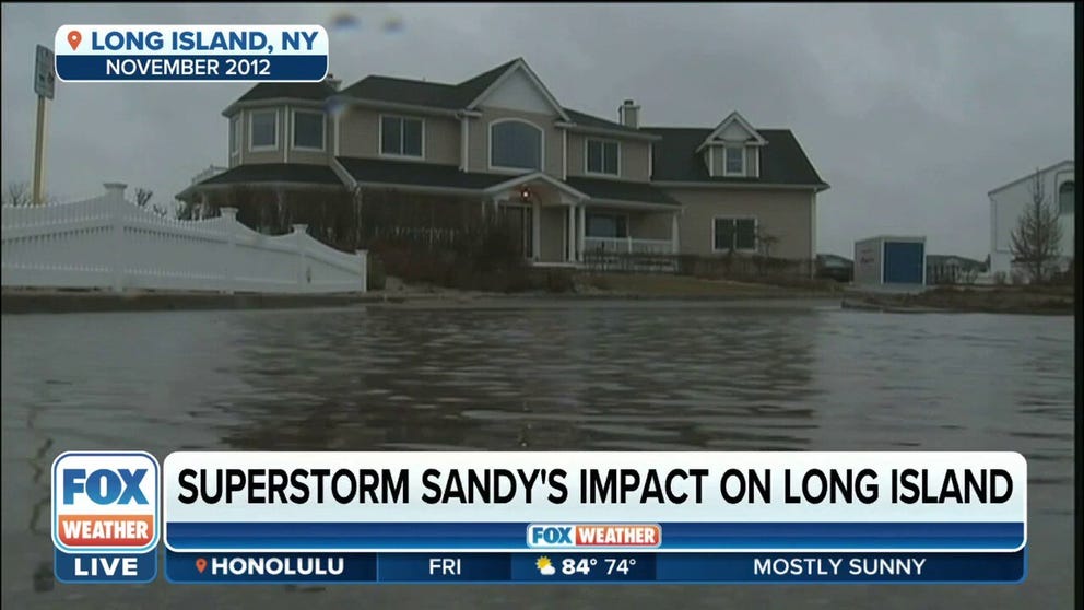
10 years after Superstorm Sandy: Some homeowners asked to give money back
Saturday is the 10-year anniversary of Superstorm Sandy, and some homeowners are still trying to recover from the historic storm. Special grants and loans from the government have helped people living along coastal communities in New York and New Jersey rebuild. But now, some people are being asked to give some of that money back. FOX News correspondent Laura Ingle has details on this new challenge Sandy victims face.
Ten years ago, Superstorm Sandy crashed ashore near Atlantic City, New Jersey, on Oct. 29, 2012, killing more than 100 people and causing billions of dollars in damage.
Despite packing sustained winds of 80 mph – equivalent to a Category 1 hurricane on the Saffir-Simpson Hurricane Wind Scale – Sandy wasn’t meteorologically considered a hurricane when it made landfall along the Jersey Shore. But that's just one reason the so-called superstorm had such a unique lifecycle, which was both climatologically normal and abnormal.
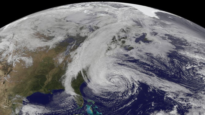
The Geostationary Operational Environmental Satellite 13 (GOES-13) captured this natural-color image of Hurricane Sandy at 1:45 p.m. Eastern time on Oct. 28, 2012. Note how a line of clouds from a continental weather system runs south to north along the Appalachian Mountains, approaching from the west to meet the offshore storm.
(NASA/NOAA)
Sandy originated as a tropical disturbance that organized into a tropical depression on Oct. 22, 2012, over the southwestern Caribbean Sea, where late-season tropical cyclones tend to develop. It moved northward and intensified into a Category 1 hurricane before striking Jamaica, and then strengthened further into a Category 3 major hurricane by the time it made its next landfall in eastern Cuba.
ATLANTIC HURRICANE SEASON CAN REMAIN ACTIVE IN OCTOBER WITH POTENTIAL U.S. THREATS
From there, Sandy weakened to a Category 1 hurricane while moving up through the central and northwestern Bahamas, continuing on a very typical path for a tropical cyclone at this time of the year.
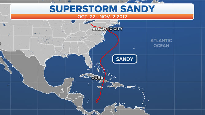
The track of Hurricane Sandy, Oct. 22-Nov. 2, 2012.
(FOX Weather)
By October, the midlatitude westerlies – prevailing winds that blow from west to east between 30 and 60 degrees latitude – tend to increase as the atmosphere begins its transition from summer to winter. These stronger winds typically steer late-season tropical cyclones out into the open waters of the Atlantic Ocean by the time they reach the latitude of about Cape Hatteras, North Carolina, nudging the storms away from the mid-Atlantic and Northeast coasts of the U.S.
Sandy ‘hangs a left’ in an unusual track
The difference with Sandy was that the weather pattern over the northeastern U.S. was not typical of late October.
A southward dip in the jet stream, or a trough, was plunging into continental North America. This brought unseasonably cold air and snow cover all the way down to the Canada-U.S. border – in late October. To the east of this trough, a northward bulge in the jet stream, or a ridge, was parked over the North Atlantic Ocean.
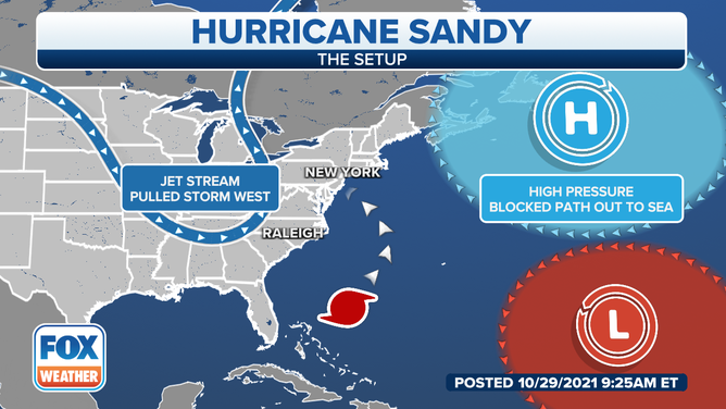
This map illustrates the weather pattern that steered Hurricane Sandy toward the New Jersey coast.
(FOX Weather)
"That combination of the ridge in the North Atlantic, with its clockwise motion around it, and the trough coming in, which brings kind of counterclockwise winds with it, was essentially serving as both a push and a pull for that storm as it came up the coast," said Dr. David Robinson, New Jersey State Climatologist. "So the ridge over the North Atlantic wouldn’t allow that storm to head out to sea and actually helped to keep it hugging the coast, and that trough off to the west was helping to actually pull the storm up the coast, and ultimately, the two combined to bring it inland perpendicular to the East Coast – and from east to west, when our weather is generally west to east."
NEW YORK CITY ARGUABLY HAS THE MOST UNIQUE WEATHER OBSERVATIONS IN AMERICA
There are many tropical cyclones in recent history that have moved from south to north up the East Coast before eventually curving out to sea. Hurricane Irene in 2011 and Hurricane Floyd in 1999 are just two notable examples.
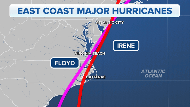
The tracks of Hurricane Irene in 2011 and Hurricane Floyd in 1999 along the mid-Atlantic and Northeast coasts.
(FOX Weather)
"But to see one come up the coast and then hang a left and head into the mainland is climatologically quite unusual," Robinson said.
Sandy stubbornly hangs onto hurricane status until final hours
Many forecasters believed the combination of the trough over North America and the time of the year (late October) would cause Sandy to lose its tropical characteristics and transition into a system more typical of a nor’easter.
The National Hurricane Center was only issuing forecasts for this storm to about as far north as Hatteras, North Carolina, with the individual National Weather Service offices then responsible for the forecasts in their areas of responsibility. Without an official National Hurricane Center forecast, Hurricane Watches and Warnings were unable to be issued along the mid-Atlantic coast.
10 years after Superstorm Sandy: Long Island building back stronger
Marc Herbst, Executive Director for Long Island Contractors’ Association, discusses how Long Island continues to build back stronger 10 years after Superstorm Sandy.
Sandy did begin to transition more toward a nor’easter-like system once it interacted with the trough. This caused it to expand in size, but it still retained its warm tropical core until within hours of making landfall in New Jersey.
WHAT'S THE DIFFERENCE BETWEEN A NOR'EASTER AND A HURRICANE?
"Ultimately, it was only about two to three hours before it made landfall in New Jersey that it was declassified as a hurricane," Robinson said. "It stayed a tropical system – a hurricane – farther north than originally anticipated."
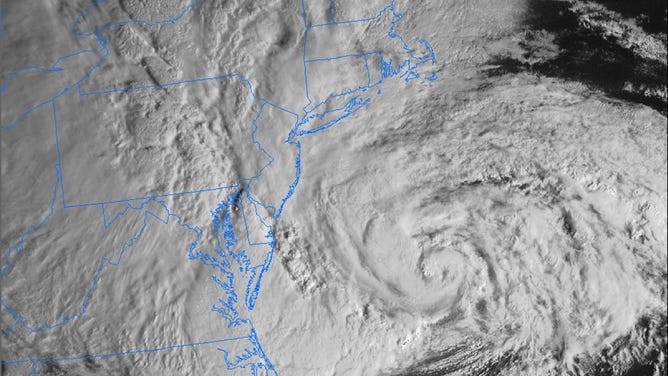
The GOES-East visible satellite captured Sandy off the mid-Atlantic coast on the morning of Oct. 29, 2012.
(NOAA)
Meanwhile, wrapping around it was this developing nor’easter, so it was a true hybrid storm.
WHAT MAKES A STORM A NOR'EASTER?
"Colloquially, it became known as a superstorm, which is not a formal definition – but truly, it was a superstorm because, by the time it got north of Hatteras, it was maintaining its winds and its tropical core," Robinson said. "It was expanding in size, so you had gale-force winds extending farther from that storm than any storm on record."
Clouds from Sandy extended from southern Greenland down into Georgia, and from the mid-Atlantic coast over toward Chicago. Very cold air was wrapping around the storm all the way from the Arctic, resulting in heavy snow in the mountains of West Virginia. Meanwhile, there were Severe Thunderstorm Warnings from Massachusetts to Montreal, Canada.
This GOES-13 satellite image was captured on Oct. 31, 2012, at 8:40 a.m. Eastern time as Sandy's circulation was winding down over Pennsylvania. Sandy had been downgraded a remnant low pressure area.
(NASA GOES Project)
Storm surges reached over 12 feet
The New York City tri-state area and the Jersey Shore were struck by the core of Sandy, but the superstorm’s effects extended thousands of miles away from its center.
"The winds were blowing over such a huge expanse of the western Atlantic that, as a result, it was pushing water up against the Jersey coast, New York, into southern Connecticut and Long Island Sound, equivalent of what would be a Category 2, maybe even a (Category) 3 hurricane," Robinson said. "So your winds didn’t say hurricane, but your storm surge said borderline major hurricane, and that’s all because it became such an enormous storm."
Kings Point, New York, on the north shore of Long Island, recorded a massive storm surge of 12.65 feet. In Manhattan, the water level at Battery Park climbed to nearly 14 feet.
Closer to Sandy's landfall location, the casino-lined boardwalk in Atlantic City, New Jersey, suffered damage as almost 9 feet of water rushed onto the barrier island. And the iconic boardwalk in Seaside Heights, New Jersey, fell into the ocean after it was unable to withstand Sandy's intense storm surge.
WATER FROM HURRICANES, TROPICAL STORMS KILLS MORE IN U.S. THAN WIND
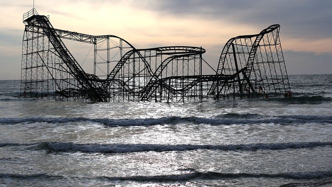
The Star Jet roller coaster fell into the water after the Casino Pier it sat on collapsed from the forces of Superstorm Sandy in Seaside Heights, New Jersey.
(Mark Wilson / Getty Images)
When adjusted for inflation, the superstorm was responsible for $81.9 billion in damage, according to NOAA’s National Centers for Environmental Information. The National Hurricane Center said in its final report that Sandy, at the time, was the second-costliest tropical cyclone to hit the U.S. since 1900, behind only Hurricane Katrina in 2005. However, it now ranks as the fourth-costliest tropical cyclone after being topped by hurricanes Harvey and Maria in 2017.
Sandy killed 159 people (72 directly, 87 indirectly) during its journey from the Caribbean to the U.S., according to NOAA. As of 2022, that ranked as the 14th-deadliest billion-dollar weather disaster to hit the U.S. in records dating to 1980.
Learn more about Superstorm Sandy by watching "Surviving a Superstorm: The Lessons of Sandy" on Saturday and Sunday at 8 p.m. and 11 p.m. Eastern on FOX Weather.
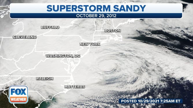
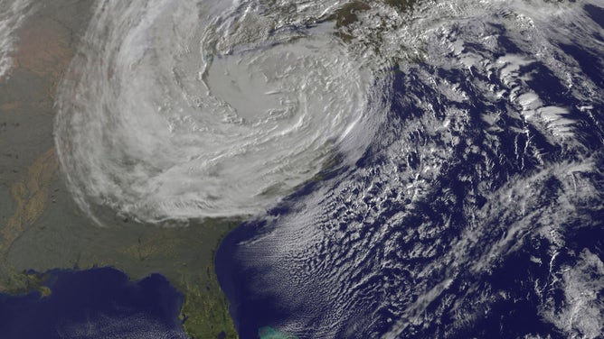
Satellite image of Superstorm Sandy off the mid-Atlantic coast on Oct. 29, 2012.
(FOX Weather)