Peak of Atlantic hurricane season begins in August
Roughly 90% of an average Atlantic hurricane season is still remaining as we head into August
Peak of hurricane season begins in August
The Atlantic hurricane season has been in slumber for nearly a month, but don't expect it to remain quiet for too much longer because the peak of hurricane season is on the way.
The Atlantic hurricane season has been in slumber for nearly a month, but don't expect it to remain quiet for too much longer because the peak of hurricane season is on the way.
Tropical Storm Colin, which briefly impacted the coastal Carolinas with heavy rain and gusty winds on July 2 and 3, was the last system to roam the Atlantic Basin.
However, it's not unusual for a lull in activity in the tropics in June or July before the season begins to ramp up in August.
HOW TO WATCH FOX WEATHER ON TV
According to the National Hurricane Center, an average June in the Atlantic features one named storm every one to two years, while July averages one named storm each year.
But as you can see in the graph below, roughly 90% of an average Atlantic hurricane season is still remaining as we head into August.
HERE'S WHY THE ATLANTIC HURRICANE SEASON RUNS FROM JUNE TO NOVEMBER
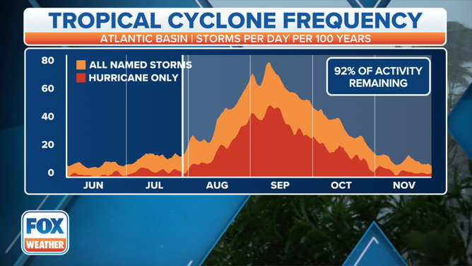
While the Atlantic hurricane season officially runs from June 1 to Nov. 30, the period from August through early October tends to produce the most hurricanes and tropical storms in an average year.
(FOX Weather)
The period from August through early October tends to produce the most hurricanes and tropical storms in an average year. September is the single most active month of the Atlantic hurricane season, with Sept. 10 marking the official seasonal peak.
Consequently, this same period is typically when the strongest, most impactful hurricanes roam the Atlantic Basin.
WHERE TROPICAL STORMS, HURRICANES TYPICALLY OCCUR DURING EACH MONTH OF ATLANTIC HURRICANE SEASON
Just in the last five years – from 2017 through 2021 – the U.S. was struck by four hurricanes in August, five in September and four in October. That included last year's Hurricane Ida, which devastated parts of southeastern Louisiana after making landfall as a Category 4 hurricane on Aug. 29.
The storm produced a powerful 14-foot storm surge along the Louisiana coastline and dumped torrential rainfall across much of the northern Gulf Coast, but its impacts didn't stop there. The storm's effects were also felt up the entire Eastern Seaboard, where tornadoes and flooding were reported as far north as New England.
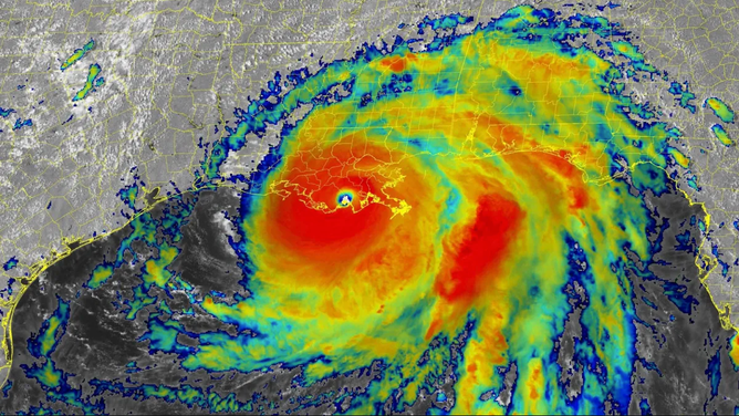
Infrared satellite image of Hurricane Ida after the storm made landfall in southeastern Louisiana on Sunday, Aug. 29, 2021.
(NOAA/NESDIS/STAR)
Hurricane Ida was blamed for the deaths of more than 100 people, and its estimated damages topped $75 billion from the Caribbean to New England. The destruction was enough to propel the storm to the fifth-costliest hurricane in U.S. history, ranking just behind Katrina, Harvey, Maria and Sandy, respectively.
The World Meteorological Organization voted in April 2022 to retire the name "Ida" from future use in the Atlantic Basin.
THE BEASTS OF THE ATLANTIC: 94 RETIRED HURRICANE OR TROPICAL STORM NAMES
Why does the Atlantic turn more active in August?
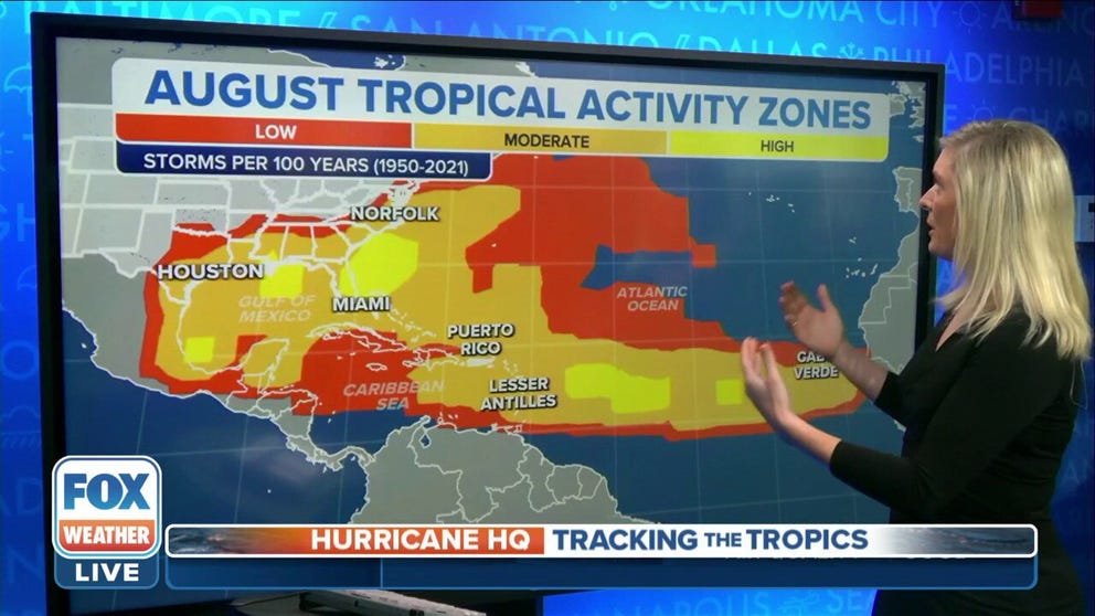
Compared to June and July, the tropics turn far more active beginning in August because nearly the entire Atlantic Basin becomes available for tropical development.
The so-called Main Development Region between Africa and the Lesser Antilles, which is typically not conducive for storms early in the season because of a frequent influx of Saharan dust and dry air into the region, turns more favorable for development as the dusty, dry air becomes less persistent.
Tropical waves also emerge off western Africa more frequently by August, and if conditions are favorable, they are often seeds for tropical development in the Main Development Region during the peak of hurricane season.
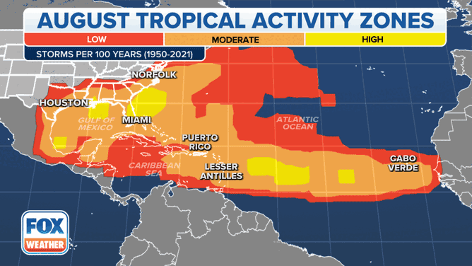
This animation shows where tropical cyclone activity tends to occur during August and September.
(FOX Weather)
If a tropical wave spawns a tropical storm or hurricane in the Main Development Region, it often moves westward across the tropical Atlantic Ocean toward the Lesser Antilles. Some of these storms make the 3,500-mile-long journey from the eastern tropical Atlantic Ocean toward the Caribbean islands or the U.S. coastline, while others curve northeastward toward Bermuda or harmlessly into the open ocean.
WHAT TO DO WHEN HURRICANE OR TROPICAL STORM WATCHES AND WARNINGS ARE ISSUED FOR YOUR TOWN
Hurricanes that develop in this area to the west of Africa are called Cabo Verde hurricanes, named after the island nation a few hundred miles west of continental Africa. Cabo Verde hurricanes are very common in September.
The Gulf of Mexico is another hot spot for tropical storms and hurricanes to form during the peak of the season because water temperatures in the Gulf reach the highest levels of the year, providing more energy for tropical cyclones to grow and intensify.
Outlook for 2022 Atlantic hurricane season
Including the three storms that have already formed this season, forecasters with NOAA's Climate Prediction Center are predicting 14 to 21 named storms, six to 10 hurricanes and three to six major hurricanes (Category 3 or higher on the Saffir-Simpson Hurricane Wind Scale).
Colorado State University's latest outlook predicts that 17 additional named storms will form this season for a total of 20. That tally includes 10 hurricanes, five of which are forecast to be Category 3 or stronger.
These numbers are greater than the 30-year averages (1991-2020) of 14 named storms, seven hurricanes and three major hurricanes.
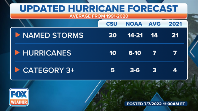
CSU and NOAA's Atlantic hurricane season outlooks for 2022 compared to the 30-year average (1991-2020) and the 2021 season.
(FOX Weather)
CLICK HERE TO GET THE FOX WEATHER UPDATE PODCAST
If the outlooks verify, this will mark the seventh-consecutive above-average Atlantic hurricane season.
Since Alex, Bonnie and Colin have already formed, the next system to become at least a tropical storm will receive the name "Danielle."
Download the FOX Weather app to track storms in your area and receive potentially life-saving weather alerts issued by the National Weather Service. The free FOX Weather livestream is available 24/7 on the app, website and on your favorite streaming platform. The FOX Weather Update podcast also provides weather information for the entire country.