Post-Tropical Cyclone Alex moves out to sea after pounding Bermuda with heavy rain, high winds on Monday
Alex peaked in intensity late Sunday night when its maximum sustained winds reached 70 mph, just 4 mph shy of a Category 1 hurricane
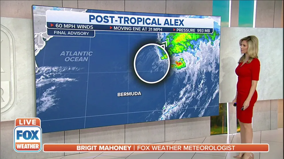
National Hurricane Center issues its final advisory for Alex
The NHC says that the storm lost all tropical characteristics and have given it the designation of Post-Tropical Cyclone Alex Monday evening.
Post-Tropical Cyclone Alex is now weakening after it pounded Bermuda with heavy rain and high winds on Monday, but the storm will continue to move away from the archipelago and out into the open waters of the central Atlantic.
The National Hurricane Center issued its final advisory for Alex on Monday evening, saying the storm lost tropical characteristics and giving it the designation as a "post-tropical cyclone."
The Bermuda Airport reported sustained winds of 43 mph with gusts up to 59 mph as Alex's center passed to the north on Monday morning. A Bermuda Weather Service buoy at Crescent Reef, just north of Bermuda, reported sustained winds of 55 mph and a gust to 72 mph. An automated weather station at the Bermuda Heliport reported sustained winds of 49 mph and a gust of 67 mph.
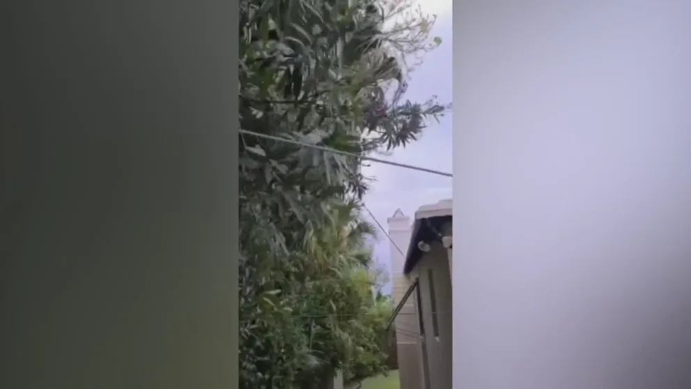
Winds up to 70 mph from Tropical Storm Alex hit Bermuda
Wind gusts up to 70 miles per hour from Tropical Storm Alex hit Bermuda on June 6. 2022. (Video: Rob Kerr via Storyful)
Tropical Storm Warnings were previously in effect for Bermuda but have now been discontinued as any lingering rain and wind impacts are expected to subside through the rest of the day.
More than 950 customers remained without power in Bermuda as of Monday afternoon.
WHAT TO DO WHEN HURRICANE OR TROPICAL STORM WATCHES AND WARNINGS ARE ISSUED FOR YOUR TOWN

(FOX Weather)
Michael Weeks, Bermuda's national security minister, announced that all public schools in Bermuda would be closed Monday and public transportation would be suspended through the morning. He also said government services would start at 1 p.m. local time following the passage of Tropical Storm Alex.
At least three American Airlines flights from Bermuda to the U.S. had been canceled as of Monday morning.
Alex is forecast to weaken through the rest of the day and will transition to a non-tropical low-pressure system later Monday. The storm peaked in intensity late Sunday night when its maximum sustained winds reached 70 mph, just 4 mph shy of a Category 1 hurricane.
Despite the storm heading away from the U.S. East Coast, rip currents will remain elevated along beaches in the Southeast through the week ahead.
HOW TO WATCH FOX WEATHER ON TV

(FOX Weather)
Alex became the first named storm of the 2022 Atlantic hurricane season early Sunday morning well off the east coast of Florida. Before it developed into a tropical storm, this system produced flooding rain across South Florida on Friday and Saturday when it was still a disorganized tropical disturbance.
"The configuration of the upper-level winds changed just enough to let it form," FOX Weather Hurricane Specialist Bryan Norcross said. "Previously, they were ripping across the disturbance. That kept it from organizing, pushing the thunderstorms and tropical moisture well ahead of the surface circulation that kept trying to form. The upper winds also injected dry air into the system, which further gummed up the works."
After Alex, it appears the tropics will remain calm for the rest of the week, at least, according to Norcross.
The average date of the first named storm is June 20, so the 2022 Atlantic hurricane season is running slightly ahead of the average pace.
South Florida recap
As the system passed over Florida, heavy rain caused flash flooding in Miami and coastal communities during the early morning hours of Saturday.
BEACHES CLOSED IN MIAMI AFTER TROPICAL DISTURBANCE CAUSES SEWAGE TO OVERFLOW
The City of Miami Fire Rescue responded to multiple calls of people stranded inside their vehicles after becoming stuck in floodwaters.
"A band of torrential rain caused widespread flooding up to waist-deep in the Miami area overnight, with other areas nearby also affected," Norcross said on Saturday morning. "The National Weather Service radar in Miami shows that a north-south swath of intense thunderstorms dumped 6 to over 12 inches of rain from Hallandale Beach, which is just south of Fort Lauderdale, down Interstate 95 through Miami to the upper Florida Keys. Three to 5 inches came all at once."
Miami received nearly a foot of rainfall, and many other locations across South Florida reported nearly a month's worth of precipitation between Friday and Saturday.
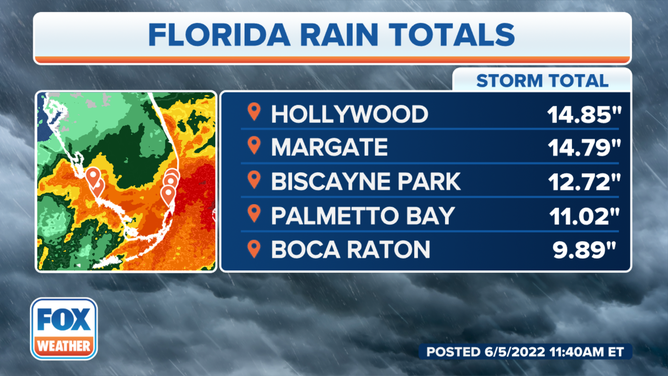
The top rain totals in Florida as of Sunday morning.
In addition to rain, the tropical disturbance created blustery conditions south of the Interstate 4 corridor.
On Saturday afternoon, Fort Pierce, Florida, reported a wind gust of 40 mph, and a weather station near Melbourne Beach, Florida, clocked a gust of 48 mph.
Wind gusts over 50 mph were recorded in southern Florida at Turkey Point (56 mph), Dania Beach Pier (52 mph) and Key West (51 mph).
The winds were responsible for occasional power outages, but by Saturday evening, most customers' electricity had been restored.
TROPICAL RAINMAKER CREATES DANGEROUS FLOODING IN SOUTH FLORIDA
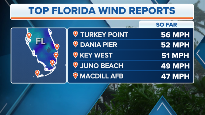
The top wind gust reports in Florida.
(FOX Weather)
Florida was not the only area that experienced life-threatening impacts from the disturbance.
In Cuba, authorities reported that the heavy rainfall caused landslides, and there were at least two deaths attributed to the system near the capital city of Havana.
CLICK HERE TO GET THE FOX WEATHER UPDATE PODCAST
FOX Weather will be extensively covering hurricane season, and the FOX Weather app is a great resource to keep you informed and has a 3D radar that you can use to track storms. The free FOX Weather livestream is also available 24/7 on the website, app and on your favorite streaming platform. The FOX Weather Update podcast also provides weather information for the entire country.