270 million Americans to feel above-average temperatures after weeks of bitter cold
While calling it "warm" might be a stretch, the temperatures will be a drastic improvement for the millions of people who shivered in below-freezing temperatures last week and over the weekend as far south as the Gulf Coast. For the South, temperatures will feel springlike – in the upper 60s and lower 70s – for Houston and New Orleans.
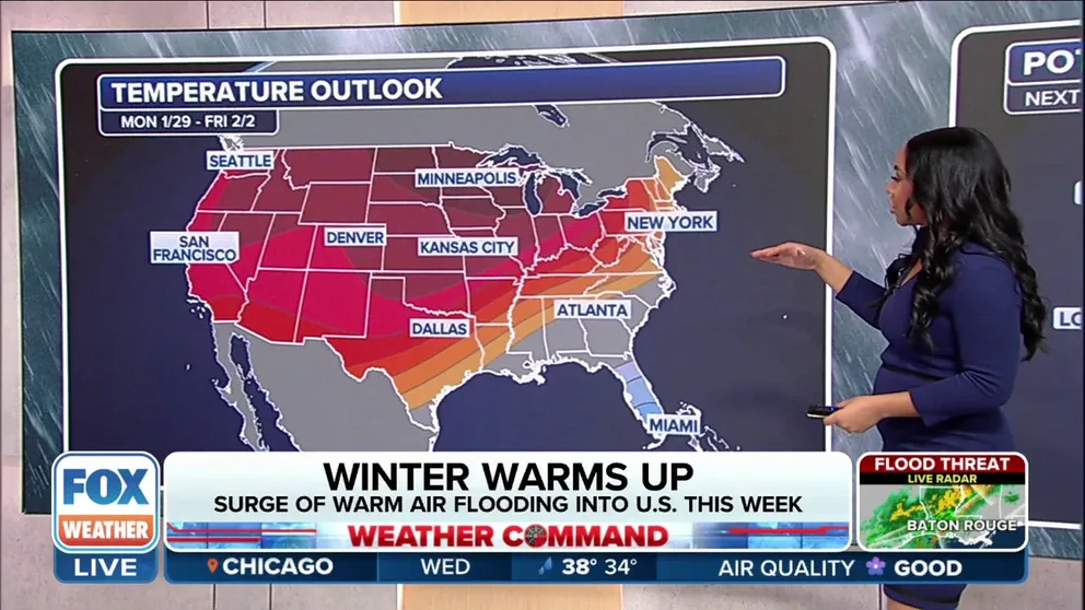
Surge of warm air producing above-average temperatures across US
Warmth moving in is providing some relief from the recent chill covering most of the U.S. Cities including New York are seeing above-average temperatures through this weekend.
Winter is loosening its cold grasp on much of America this week as a pattern change brings above-average temperatures for millions and needed relief from the recent arctic air invasion.
Temperatures have been moderating all week, and by Friday, the warmup will cover nearly 270 million people across the U.S. It'll be the warmest temperatures in over a week, according to the FOX Forecast Center.

(FOX Weather)
"We've been waiting for the warmer conditions," FOX Weather Meteorologist Craig Herrera said. "Here it is … all of that cold air gets bottled back up to the north, and we'll hold on to these nice, steady, warmer temperatures… for at least a week here."
WHEN IS THE COLDEST TIME OF YEAR?
While calling it "warm" might be a stretch, the temperatures will be a drastic improvement for the millions of people who shivered in Wind Chill Warnings and below-freezing temperatures last week and over the weekend as far south as the Gulf Coast.
The change is apparent when you compare the numbers from last week. Some cities across the Southeast will experience a more than 50-degree temperature swing this week, including Memphis and Birmingham. Even cities like Washington, D.C. and Philadelphia are going from lows in the teens last week into the 50s this week.

(FOX Weather)
For many of those in the Midwest and northern Plains, temperatures rose above freezing Wednesday. It might not seem like a big change, but these areas have seen high temperatures in the teens over the past week.
Billings in Montana, Minot in North Dakota and Minneapolis ended the weekend with temperatures at or below zero. On Wednesday and Thursday, the high in Minneapolis is forecast to hit the mid-30s.
WHY 50 DEGREES FEELS FRIGID TO SOME BUT WARM TO OTHERS: THE SCIENCE OF ACCLIMATION
To the south in Kansas City, which dipped to a low temperature of 3 degrees at the end of the weekend, the forecast high in the lower 40s by Wednesday will feel downright refreshing.

(FOX Weather)
The temperatures will slowly increase for the mid-Atlantic and Northeast, with afternoon highs in the mid-40s and 50s by Wednesday and Thursday. Philadelphia and Washington could even reach the 60s on Friday.
Pittsburgh ended the weekend with a high of 25 degrees on Sunday; by Thursday, temperatures are forecast to climb into the mid-50s – a sharp 30-degree warmup in just five days.
TEXAS, NEW ORLEANS FACE MULTIDAY FLASH FLOOD THREAT AS HEAVY RAIN RETURNS TO SOUTHEAST THIS WEEK
Meanwhile, places across the South will get a taste of springlike temperatures. Mild overnight temperatures will mean potential record-warm lows across the mid-Atlantic and Southeast on Thursday and Friday mornings.

(FOX Weather)
This week snowbirds overwintering in Florida will get the January temperatures they come for, making their friends and family jealous to the north.
On Sunday, the high in Jacksonville, Florida, only hit 44 degrees. By Friday, the Bold City of the South could hit 80 degrees.
High temperatures in Houston and New Orleans will reach the upper 60s and lower 70s starting Tuesday afternoon and continuing through the rest of the week.

(FOX Weather)
Will the warmer temperatures last?
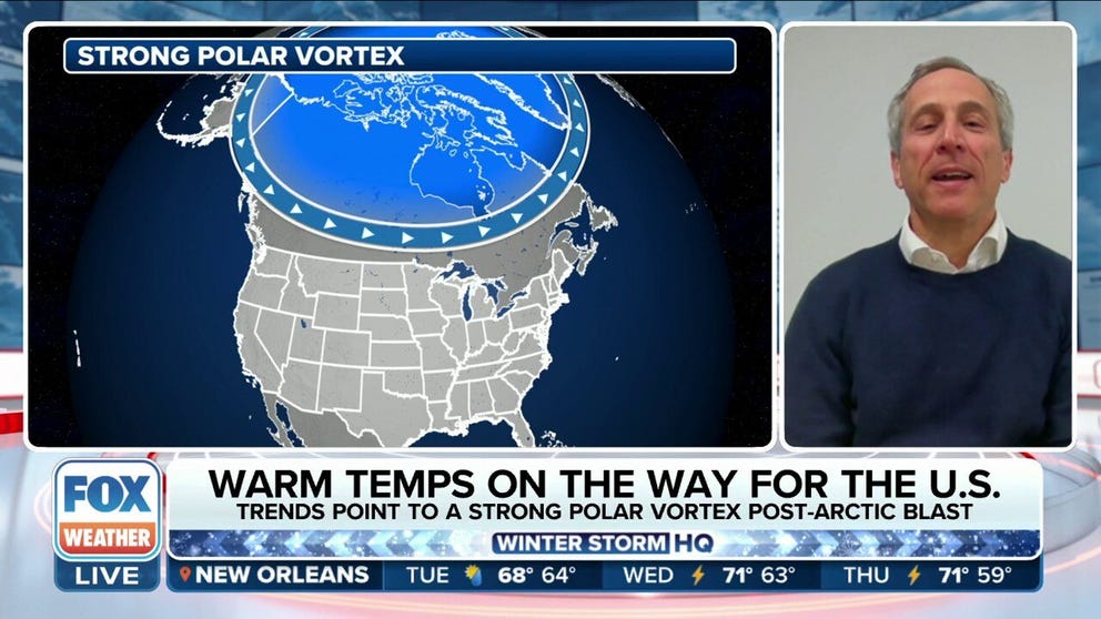
Models point to a warmer end to winter for US
Atmospheric Research Scientist Judah Cohen explains what models show the rest of winter will look like for the U.S.
By the end of the weekend, winter's grip returns for many across the U.S.
"Don't let this warm up fool you. As we said, we've got plenty of winter to go through," FOX Weather meteorologist Britta Merwin said. "February is a huge month for winter. We usually see our coldest temperatures; the majority of our snowstorms."
Major cities in the Northeast see the majority of their snow in February. After reaching above-average temperatures, the cold air will return toward the end of this weekend.
However, models show the rest of the winter is likely to be mild compared to the deep chill from early January, Atmospheric Research Scientist Judah Cohen told FOX Weather.
This is because the polar vortex, which drives the cold air around the world, is now in a tight rotation, Cohen explained. If the polar vortex loses that tight spin, the rotation slows down and the cold air moves away from the center of that rotation.

The polar vortex on the left was from January 1 and the right is the forecast for January 14 showing the cold air stretching south.
(NOAA Climate.gov)
"The polar vortex is like a figure skater when it's a nice tight rotation that keeps the cold air close to the center of rotation, just like the figure skater's hands are close to the head, close to the body … so the cold is over the Arctic," Cohen said. "But if the figure skater stumbles and falls and its rotation slows down everything moves away from the center rotation, the arms start to well out and the cold air moves south."
Cohen said the U.S. will have a mild end of January because the polar vortex is once again in a tight spin.
However, Cohen said winter is not over. He said it's likely a similar event that brought the Arctic air down into the lower 48 in January will happen again.
"I think there's a good chance that will repeat itself in February. So look for a mild pattern. I don't think it's the end of winter," Cohen said. "It's not a breakdown of the pattern, but I think a relaxing pattern. And look for colder air, chance of snow to return, I think towards mid-February."