Texas, Gulf Coast brace for days of flooding as torrential rain, severe weather return to Southeast
Cities such as Houston and New Orleans could see several inches of rainfall this week as multiple waves of moisture are expected to impact the Interstate 10 corridor. Some embedded thunderstorms with plenty of lightning, damaging wind gusts and even possible tornadoes could develop.
Days of rain headed for the Gulf Coast states
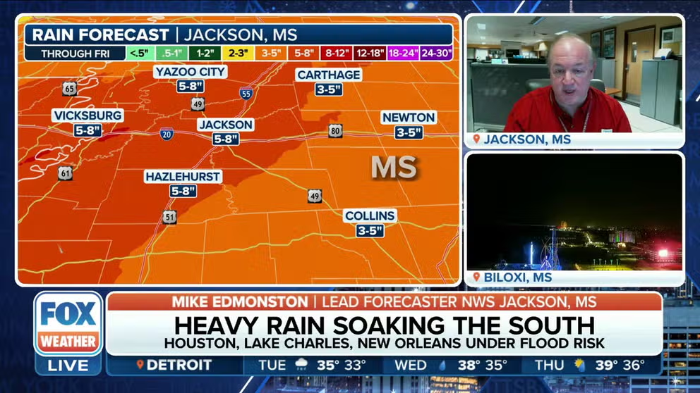
Rounds of heavy rains and thunderstorms are headed through states from Texas to Georgia through the entire work week. FOX Weather talks to NWS Jackson, Mississippi Lead Forecaster, Mike Edmonston to find out how many inches of rain to prepare for.
HOUSTON – A multiday wet-weather event has the Gulf Coast and Southeast on alert for flash flooding, with many communities, including Houston, bracing for 3-5 inches of rain and isolated areas seeing even more precipitation.
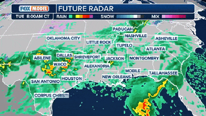
FOX Future Radar through Thursday.
(FOX Weather)
According to the FOX Forecast Center, the same weather pattern that is going to deliver above-average temperatures through much of the Lower 48 will allow for moisture to build up along the Gulf Coast, leading to an eventual flash flood and severe weather threat.
FLOOD WATCH, WARNING AND EMERGENCY: HERE ARE THE DIFFERENCES THAT COULD SAVE YOUR LIFE
![fox weather]() Image 1 of 5
Image 1 of 5Flash flood threat ( )
![]() Image 2 of 5
Image 2 of 5Tornado threat. ( )
![]() Image 3 of 5
Image 3 of 5Strong wind threat. ( )
![]() Image 4 of 5
Image 4 of 5Severe weather threat. ( )
![]() Image 5 of 5
Image 5 of 5Flood alerts. ( )


Multiple waves of moisture will impact the Interstate 10 corridor, and some of those could have embedded thunderstorms with deadly lightning, damaging wind gusts and even possible tornadoes on Tuesday.

(FOX Weather)
Flash flood risk
The flash flood risk, according to the FOX Forecast Center, will shift farther to the east each day. Monday doused South and Central Texas.
The slow movement of the rain will allow for rivers to rise, but it’s not entirely clear how high they will get.
WHAT ARE THE ARCTIC OSCILLATION, NORTH AMERICAN OSCILLATION AND MADDEN-JULIAN OSCILLATION?

(FOX Weather)
The FOX Forecast Center said that most locations will see their rain totals spread over a long enough period of time to keep the flooding impacts minimal.
However, some locations will see too much rain in a short period of time, which will result in a higher flash flood threat.
Austin-Travis County EMS (ATCEMS) in Texas said there are currently 30 low-water crossings across the area that have been closed due to high water, and more may be added as the heavy rain continues to pound the region.
The Texas Division of Emergency Management said it activated state emergency response resources ahead of the heavy rain and flood threat due to the potential impacts.
"State responders and equipment are ready to support needs from Texas communities," TDEM said on X, formerly Twitter. "Now is the time to prepare."
NATIONAL WEATHER SERVICE REVAMPS FLOOD ALERTS
How much rain will fall in the Southeast and Gulf Coast by the end of the week?

(FOX Weather)
According to the FOX Forecast Center, a wide swath of the Gulf Coast and Southeast could pick up 3-5 inches of rainfall, with isolated areas approaching 10 inches.
Both Houston and New Orleans are included in the excessive rainfall zone, where totals could reach around a half-foot by the end of the week.

(FOX Weather)
As accumulations mount, so will the potential for flash flooding, which will likely require watches and warnings to be issued during the workweek.
Many of the communities that stand to see rainfall are dealing with a precipitation deficit, so the rainfall could be welcome news.
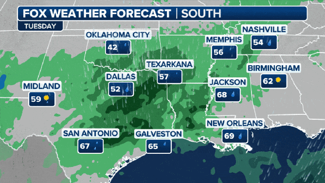
A look at weather and threats day-by-day through the South.
(FOX Weather)
Winter in rearview mirror
The precipitation will fall in the liquid variety due to warming temperatures through the week.
Temperatures are expected to moderate through the workweek, with highs reaching the 60s and 70s for many in the South.
Where the greatest extent of cloud cover and rain exists, there will be a tendency for temperatures to remain cooler compared to communities that will get much more sunshine. Even with the clouds, highs and lows are still expected to remain above average for the foreseeable future.

(FOX Weather)