What are the Arctic Oscillation, North American Oscillation and Madden-Julian Oscillation?
An oscillation is a recurring climate cycle that is typically influenced by sea surface temperatures, pressures and other rudiments of the daily weather. The most well-known of Earth’s oscillations is the El Niño-Southern Oscillation (ENSO), which consists of statuses such as La Nina, neutral and El Nino.
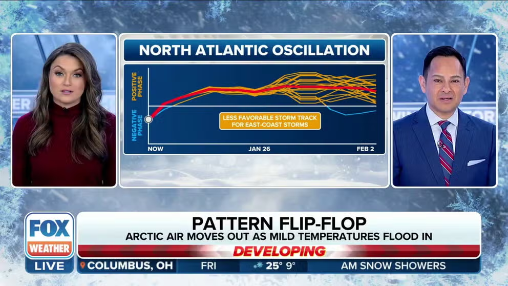
Explaining the North Atlantic Oscillation
What does it mean when the North Atlantic Oscillation heads into a positive or negative phase? FOX Weather explains.
You've likely heard of El Niño and La Niña, which are part of the El Niño-Southern Oscillation, but many other oscillations can affect weather patterns.
The North Atlantic Oscillation (NAO), Arctic Oscillation (AO) and Madden-Julian Oscillation (MJO) are three that can have major implications on the climate in North America.
An oscillation is a recurring climate cycle that is typically influenced by sea surface temperatures, atmospheric pressures and other variables of daily weather.
When one oscillation goes into a negative phase, a neighboring oscillation can go into a positive phase, and vice versa. Each can impact everything from air temperatures to precipitation patterns.
These relationships are called teleconnections, and according to scientists, some variabilities are still poorly understood. But the more oscillations that point to a particular pattern, the more confidence forecasters have in warning of potential weather extremes.
WHAT ARE EL NINO AND LA NINA CLIMATE PATTERNS?
Arctic Oscillation (AO)
The status of the Arctic Oscillation is determined by atmospheric pressure over Earth’s North Pole.
When pressures around the Arctic Circle are low, the AO is considered to be in a positive state, and when pressures are higher, the oscillation is said to be in a negative state.
During the positive stage, the polar jet helps keep the cold air bottled up around the pole.
"The cold air gets sucked back up toward the poles and that means mild air is left behind for the U.S.," says FOX Weather Meteorologist Britta Merwin.
The combination of low pressure and the air circulating around the region creates what is commonly referred to as the polar vortex.
![Polar Vortex Stable]() Image 1 of 2
Image 1 of 2Polar Vortex Stable ( )
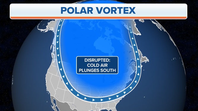
![Polar Vortex Disrupted]() Image 2 of 2
Image 2 of 2Polar Vortex Disrupted ( )
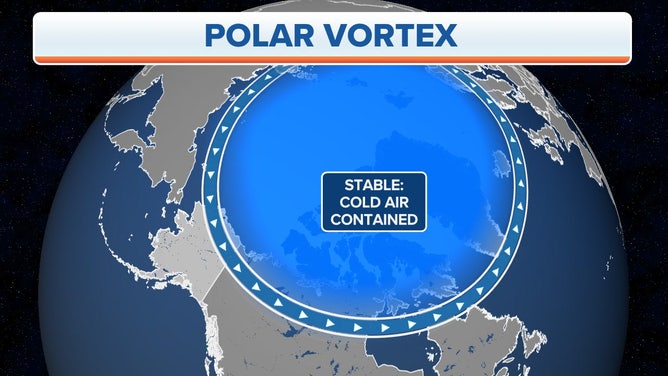
During this phase, arctic air masses are usually confined to Alaska, Canada and regions above 50 degrees north latitude.
But higher-than-normal pressures over the polar region can turn the AO negative, which can mean significant consequences.
A relaxation of upper-level winds can allow for cold air to drop out of the polar region and through most of North America, perhaps bringing historically low temperatures.
For example, the AO index turned negative in January, and when it reached its lowest value of the new year, the U.S. saw the most significant cold snap of the season.
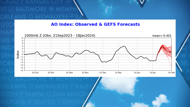
AO Index in 2023-2024
(FOX Weather)
North Atlantic Oscillation (NAO)
This cycle revolves around low pressure centered around Iceland and high pressure located near the Azores in the North Atlantic.
If the Icelandic low and Azores high are stronger than normal, the NAO is considered to be in positive territory.
This positive value results in a stronger jet stream that is positioned at more northern latitudes.
During the North American winter, this status can lead to less stormy weather over the eastern half of the country and more mild conditions.
No truer example can be found than in 2023, when the U.S. set a new record for the warmest December.
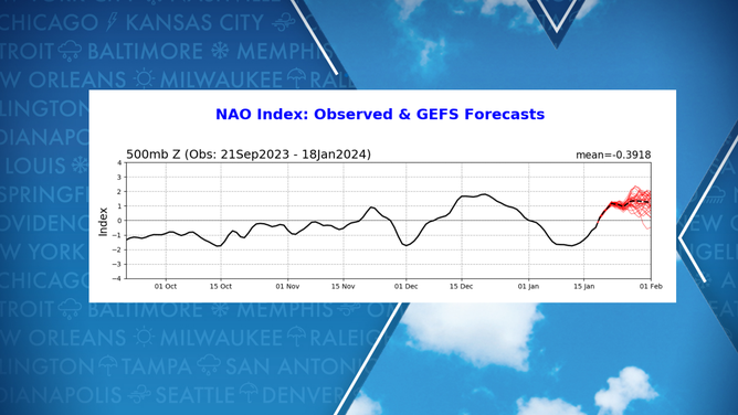
NAO index during 2023-2024
(FOX Weather)
According to NOAA, the month’s temperature averaged 7.3 °F above normal, causing it to rank as the warmest December in 129 years of records.
On the opposite side of the season spectrum, tropical cyclones are more likely to interact with the North American coastline during a positive NAO than when it is negative.
During a negative phase during the winter, the U.S. experiences stormier weather, with dips in the jet stream and cold air outbreaks.
The NAO index was in negative territory for the first half of January 2024, and the period became known for its winter storms and severe weather.
Madden-Julian Oscillation (MJO)
The MJO is an eastward traveling pulse of waves of enhanced moisture and dry air that impact areas along the equator and the subtropics.
It is estimated that any one particular point within the MJO takes 30-60 days to circle the globe.
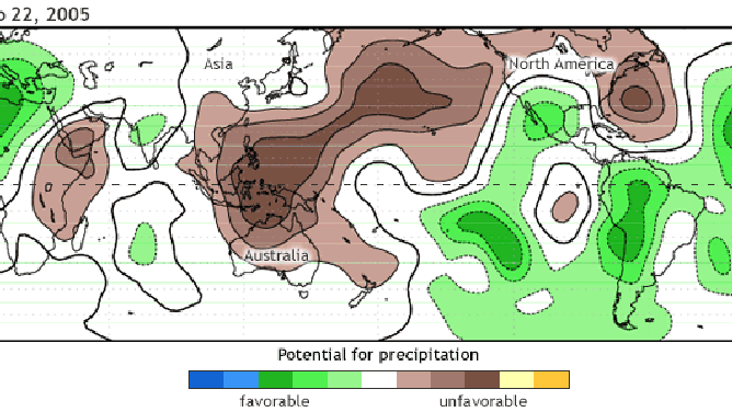
MJO animation of favorable and unfavorable waves for precipitation
(NOAA)
During the summer and fall, the MJO can lead to an increase in hurricane activity in regions considered to be in enhanced precipitation zones and a decrease in tropical cyclone activity in suppressed regions.
WHY TORNADO ALLEY IS SHIFTING EAST
During the winter, the wet phase of the MJO can lead to enhanced rainfall along the West Coast, an energized Pineapple Express and a significant cold invasion on the East Coast.
Take the status of the MJO on Jan. 9, 2024, for example. An area of anomalous divergence – a region that is favorable for precipitation – existed over a large part of North America and that likely contributed to extreme weather from blizzards in the Midwest to severe weather in the Southeast.
Forecasters can monitor the phases of the MJO as they circle the planet to get a general idea of which way the forecast might lean- whether it will be stormy or more subdued.
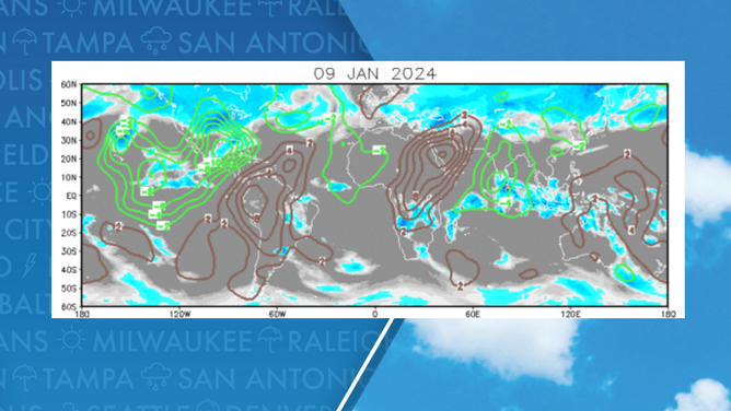
MJO on January 9, 2024
(FOX Weather)