Here’s what an El Nino climate pattern is
Warming sea surface temperatures in the central-east equatorial Pacific lead to the formation of an El Niño climate pattern. The last El Niño occurred in 2018-2019, and according to long-range NOAA outlooks, the world could return to El Niño status in late 2023.
The meaning of El Nino and La Nina
The status of whether the world is being impacted by an El Nino or a La Nina is determined by water temperatures in the central and eastern Pacific. (NOAA)
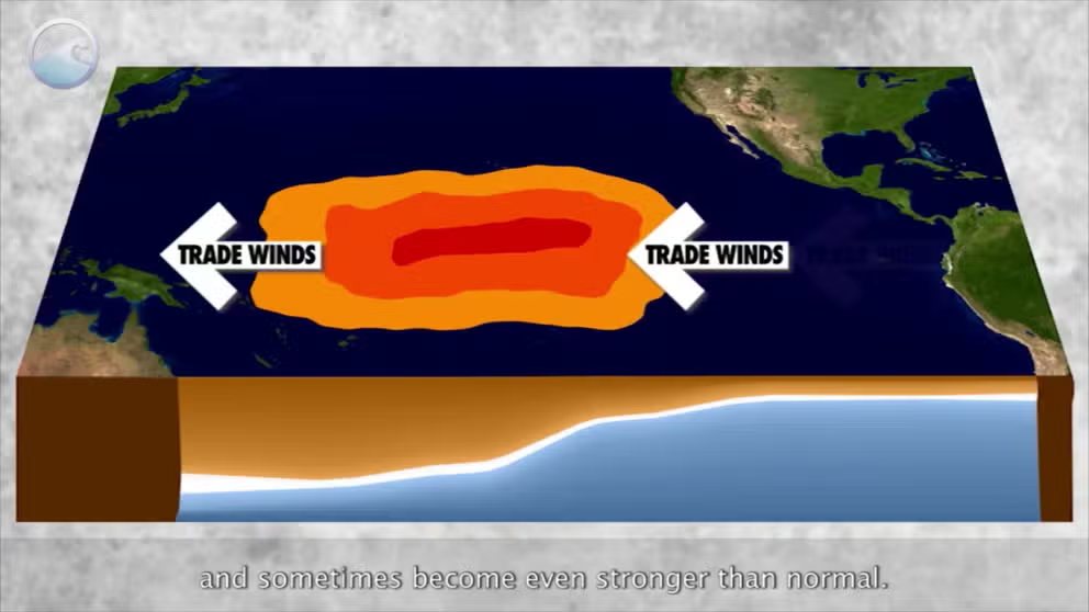
The warming of the central and eastern Pacific Ocean can have significant impacts on global weather, and when sea surface anomalies reach 0.5 °C or warmer than what is typical, an El Niño is considered to be underway.
The status of the ocean’s variations is known as the El Niño-Southern Oscillation or what is commonly referred to as the ENSO. The three categories that make up the ENSO are: La Niña, neutral and El Niño.
Due to a rare triple-dip La Niña event that began in 2020, the world hasn’t seen the impacts from an El Niño since 2019, and the last strong occurrence was back in 2015-16.
The natural changes in sea surface temperatures are driven by winds over the equatorial region of the Pacific. NASA says when easterly trade winds slow or even become westerly warm water tends to percolate off the west coast of South and Central America – a telltale sign of an El Niño.
El Niño has been dubbed by some to be the world’s ultimate "master weather-maker" as its influences impact everything from animal migrations to the amount of billion-dollar disasters reported around the globe.
HOW SALMON NUMBERS RISE AND FALL DURING EL NINO AND LA NINA
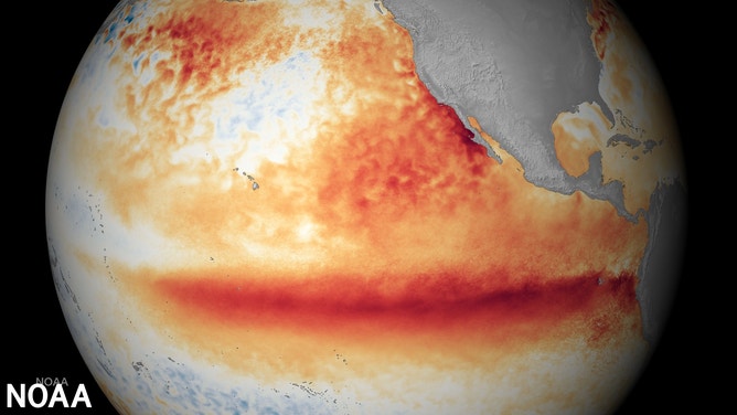
Satellite sea surface temperature departure in the Pacific Ocean for the month of October 2015.
(NOAA)
El Niño U.S. winter impacts
El Niño events typically have great impacts on weather around the country during meteorological winter, which runs from December through February.
Depending on the event’s strength, the southern tier of the country usually sees cooler-than-average temperatures, while the northern half can experience occasional breaks from the brutally long winters.
The impacts can be significant along the West Coast and lead to enhanced precipitation.
![Winter precipitation anomalies]() Image 1 of 2
Image 1 of 2Winter precipitation anomalies during weak, moderate and strong events ( )
![Winter temperature anomalies]() Image 2 of 2
Image 2 of 2Winter temperature anomalies during weak, moderate and strong events ( )


All El Niño events are not similar, and NOAA says despite more than four decades of research, it continuously monitors important regions to better understands impacts.
Major El Niño events in 1982-83 and 1997-98 produced more than 150 percent of average precipitation in the Golden State, but the record-breaking El Niño of 2015-16 led to less rainfall than during even non-El Niño events.
WHAT ARE EL NINO AND LA NINA CLIMATE PATTERNS?
El Niño U.S. summer impacts
Impacts from El Niño are generally experienced more during the winter months than the summertime, but there are still influences to look out for.
Climatologists say the jet stream is usually further north and weaker, which limits the variability experienced during other seasons.
Depending on the exact strength of the El Niño, the country as a whole experiences cooler-than-average temperatures during the summer, with dry conditions in the East and increased rainfall in the West.
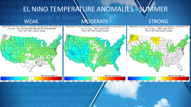
Summer temperature anomalies during weak, moderate and strong events
(NOAA)
Despite the apparent trend of cooler conditions during the summer, the world usually sets yearly records for warmth during El Niño events.
"During El Niño, unusually warm sea surface temperatures in the central/eastern tropical Pacific lead to increased evaporation and cooling of the ocean. At the same time, the increased cloudiness blocks more sunlight from entering the ocean. When water vapor condenses and forms clouds, heat is released into the atmosphere. So, during El Niño, there is less heating of the ocean and more heating of the atmosphere than normal," National Oceanic and Atmospheric Administration experts wrote in a 2022 ENSO blog.
TRANSITION INTO EL NINO COULD LEAD TO RECORD HEAT AROUND THE GLOBE
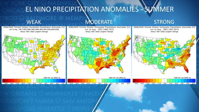
Summer precipitation anomalies during weak, moderate and strong events
(NOAA)
El Niño Atlantic basin hurricane impacts
El Niños are known to suppress tropical activity in the Caribbean, Gulf of Mexico and Atlantic Ocean.
NOAA said the impacts primarily stem from increased vertical wind shear, which can prevent tropical cyclones from forming and strengthening.
Additionally, the atmosphere over the Atlantic basin tends to be more stable, and water temperatures are usually cooler during El Niño years.
Hurricane researchers have found that U.S. threats during La Niña years outnumber El Niño impacts at a three-to-one ratio but caution an El Niño year does not mean coastal communities are threat free.
El Niño influences were around in 2018 and 2019, but hostile conditions in the Atlantic did not dominate the heart of the hurricane seasons. This allowed named storm totals to reach the above-average threshold in both years.
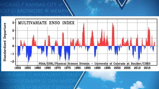
Red periods of time indicated above average water temperatures and blue patches indicate below normal water temperatures.
(NOAA)
5 DIFFERENT NAMES FOR HURRICANES AROUND THE WORLD
The last hurricane season to be greatly influenced by the full effects of an El Niño was 2015. During the season, 11 named storms formed, four strengthened into hurricanes and only two reached Category 3 strength or greater.
Many weather experts point to the 1992 hurricane season as a classic example of when El Niño conditions were in control and as a reason why to never let your guard down.
The season's first tropical storm wasn’t named until August 17, but the cyclone went on to become one of the most devastating in U.S. history.
Hurricane Andrew made landfall along southeastern Florida as a Category 5 on August 24, 1992, with winds estimated to be around 165 mph.
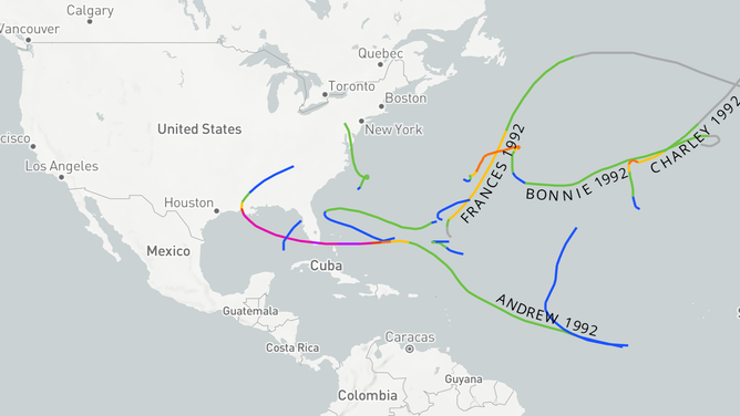
1992 tropical cyclone map
(NOAA)