Massive winter storm, expected blizzard will snarl Christmas week travel with life-threatening conditions
Blizzard conditions are expected in parts of the Midwest and Great Lakes on Thursday and Friday, which will lead to devastating impacts on holiday travel, including the potential for prolonged flight delays or numerous cancellations at Chicago O'Hare International Airport.
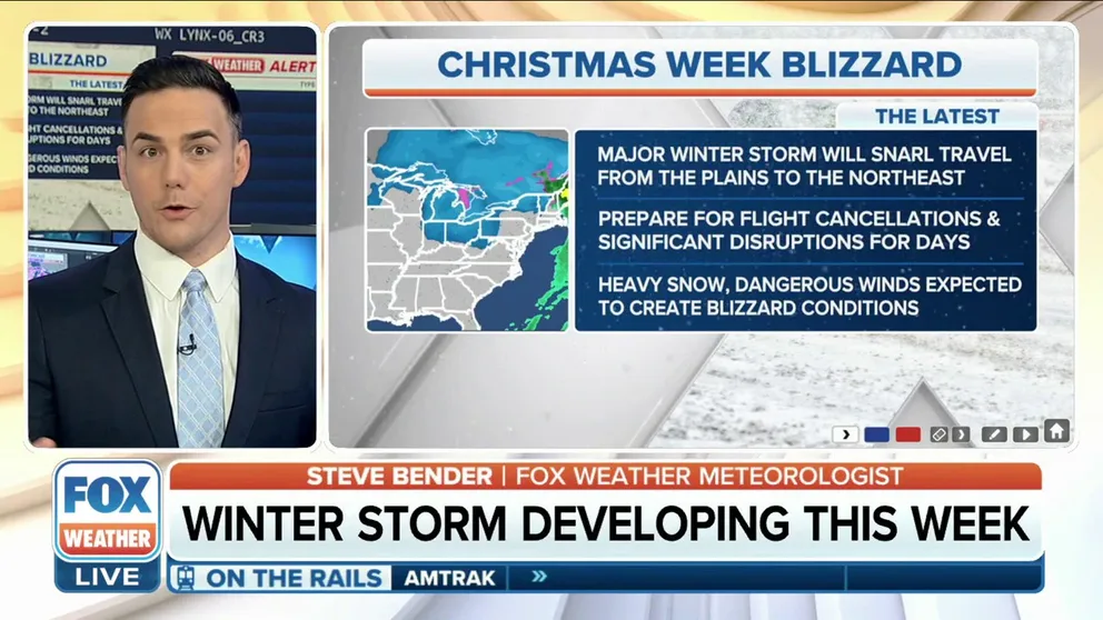
Christmas week blizzard will snarl travel for millions
A dangerous blizzard and the arctic blast that will follow, will lead to potentially life-threatening conditions and massive travel delays in the days leading up to Christmas.
A massive winter storm is brewing for millions across the Midwest, Great Lakes and Northeast, packing dangerous threats of heavy snow, rain, damaging winds and plummeting temperatures that could snarl travel at the peak of the busy holiday season.
Forecast details for this winter storm are now coming into focus. A far-reaching, highly-impactful storm system will affect millions of people starting Wednesday, with peak impacts expected from Thursday through early Saturday (Christmas Eve).
In fact, blizzard conditions are expected in parts of the Midwest and Great Lakes on Thursday and Friday, which will lead to devastating impacts on holiday travel, including the potential for prolonged flight delays or numerous cancellations at Chicago O'Hare International Airport.

(FOX Weather)
"The next two days are your getaway days. As we go into the end of the week, that's when we see some big-time issues, especially for Friday," FOX Weather meteorologist Britta Merwin said. "Friday is one of the biggest travel days that we will see for the entire week, and that's when we will see the majority of the snow, the strongest winds, and of course, a lot of rain, especially for the East Coast."
DON’T LEAVE ANY OF THESE ITEMS IN YOUR CAR THIS WINTER

(FOX Weather)
Wednesday-Wednesday night: Snow, gusty winds spread from Rockies to Plains
Light to moderate snow will first develop Wednesday across the northern Rockies along and ahead of the arctic cold front charging south out of Canada. The snow will then spread into the northern Plains on Wednesday afternoon.
According to the FOX Forecast Center, there remains uncertainty in how far east the snow will spread, with some indication that it might reach as far as Wisconsin by sunset. However, the snow should remain relatively light, with only a few inches expected.

(FOX Weather)
Wednesday night, the snow will continue to spread south and eastward ahead of the cold front, potentially reaching as far south as Oklahoma and as far east as Michigan by early Thursday.
The snowfall will be accompanied by gusty winds between 30 and 55 mph, which could make travel hazardous from Kansas to Wisconsin.
TRAVELING THIS WINTER? HERE’S WHAT TO KEEP IN YOUR CAR IN CASE YOU GET STUCK
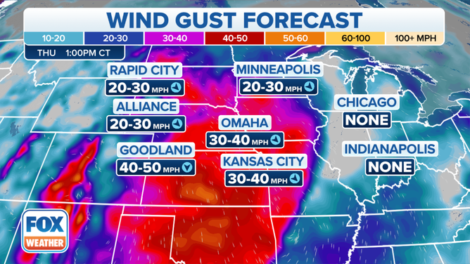
Wind gust forecast in the Plains and Midwest.
(FOX Weather)
Thursday-Friday: Virtually impossible travel as blizzard conditions wallop Midwest, Great Lakes
From there, the FOX Forecast Center predicts an area of low pressure will develop in the Midwest and rapidly strengthen into a powerful low-pressure system over the Great Lakes.
That will allow heavy snow, fueled by moisture from the Great Lakes, to bury portions of the Midwest. The dangerous combination of high winds and falling snow could reduce visibility to near-zero at times, which would make travel virtually impossible for some parts of the region in the days leading up to Christmas weekend.
WHAT ARE THE WORST AIRPORTS TO FLY INTO DURING WINTER?
According to the FOX Forecast Center, blizzard conditions are likely Thursday and Friday. A snowstorm must reach the following criteria to become an official blizzard: sustained winds or frequent gusts to at least 35 mph and considerable falling and/or blowing snow that frequently reduces visibility to one-quarter mile or less, both of which must persist for a period of three hours or longer.
Major travel disruptions are a serious concern for anyone who will be flying through Chicago O'Hare International Airport on Thursday or Friday.

(FOX Weather)
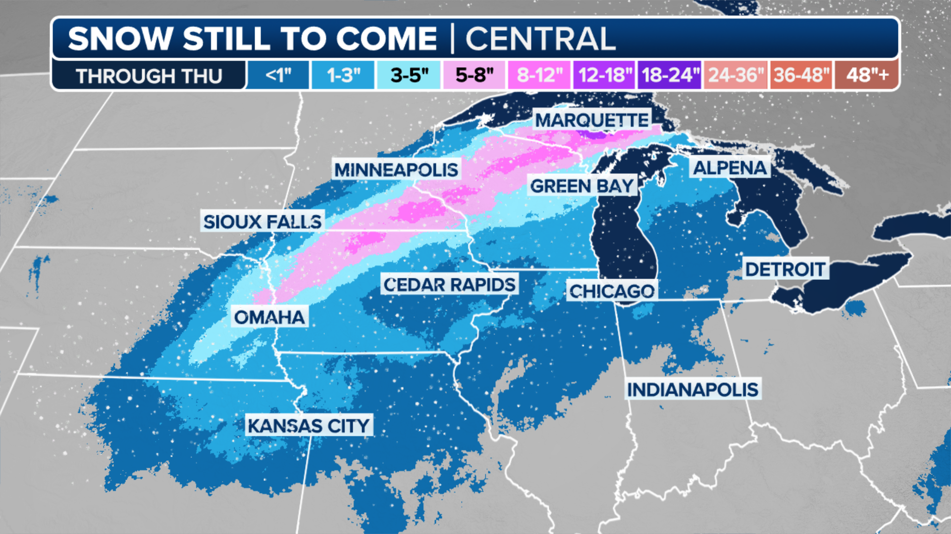
Many areas from the eastern Plains to the Upper Midwest and Great Lakes are predicted to receive at least 6 inches of snow from this winter storm.
More than a foot of snow is likely across portions of northern and southeastern Wisconsin, northeastern Illinois, northern Indiana and western and northern Michigan. This could potentially include the cities of Chicago and Milwaukee.
The Upper Peninsula of Michigan and parts of far northern Wisconsin will likely receive more than 2 feet of snow due to enhancement from Lake Superior.
THESE ARE THE 7 SNOWIEST CITIES IN THE U.S.
(FOX Weather)
Wind gusts are expected to reach 50 to 70 mph, which would likely lead to tree damage and cause numerous power outages. This would be a dangerous situation ahead of the arctic blast following immediately in the wake of the storm.
HERE’S WHAT TO HAVE ON HAND IF THE POWER GOES OUT DURING A WINTER STORM
Friday-Saturday: Heavy rain, damaging winds could cause widespread power outages in East
Most of the East will see a soaking rain rather than snow from this winter storm, but significant impacts are still expected as damaging winds will blast the region from Friday into early Saturday (Christmas Eve).
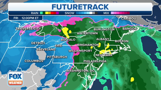
FOX Weather FutureTrack for Friday, Dec. 23, 2022.
(FOX Weather)
According to the FOX Forecast Center, widespread 60-plus-mph wind gusts are likely, and there is the potential for gusts even reaching as high as 80 mph as the arctic cold front passes through on Friday or Friday night.
At least scattered power outages are expected, and more widespread outages are certainly possible. Again, this would be a dangerous situation with the bitterly cold temperatures and wind chills arriving Friday night and continuing through Christmas weekend.
BATTEN DOWN THE HATCHES: WHAT YOU SHOULD KNOW ABOUT HIGH WINDS

(FOX Weather)
In addition to the wind, between 1 and 3 inches of rain is expected to soak the mid-Atlantic and Northeast, with localized totals exceeding 3 inches not ruled out.
Flash flooding could become a concern, especially in areas of the interior Northeast that have several inches of snow on the ground following last week's winter storm.
Additionally, along the immediate East Coast, coastal flooding could develop at high tide Thursday and Friday because of two days of strong onshore winds off the Atlantic.
EXPLAINING FLOOD ALERTS ISSUED BY THE NATIONAL WEATHER SERVICE
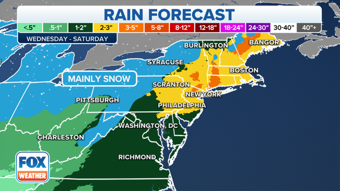
Rainfall forecast in the mid-Atlantic and Northeast.
(FOX Weather)
Any snow in the East with this next storm will likely be confined to northern New England, portions of upstate New York, the Ohio Valley, western and central Pennsylvania and the higher elevations of the central Appalachians.
While accumulations will remain light in most areas, at least 6 inches of snowfall is possible to the east of lakes Erie and Ontario in western and northern New York, northern Ohio and portions of western Pennsylvania due to lake enhancement.

(FOX Weather)
The storm will gradually wind down through the day on Christmas Eve as the low-pressure system moves north into Canada.
However, gusty winds will continue, which will send wind chills to dangerous levels, especially for any people without power.

(FOX Weather)