How high pressure and low pressure drive the weather
High and low pressure areas drive the weather as a way to even out unequal heating from the sun. Check out some of the common weather patterns that the meteorologists at FOX Weather point out all the time.
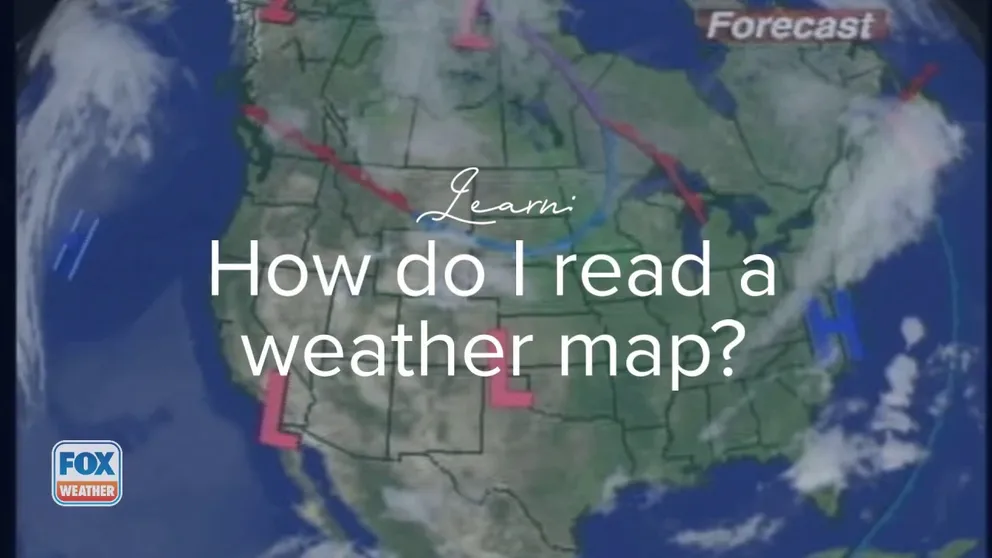
How do I read a weather map?
FOX Weather tells you how those highs and lows form on the weather map and what they mean to the weather outside.
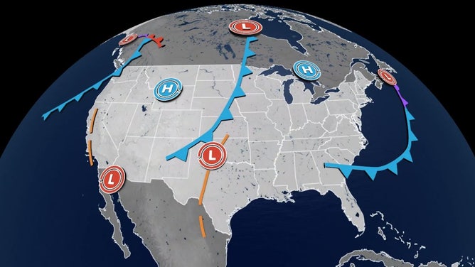
Meteorologists are undoubtedly familiar with the "highs" and "lows" of weather on Earth, thanks to changes in atmospheric pressure. But have you ever wondered why we're always so infatuated with all those blue H's and red L's on a weather map?
Differences in air pressure are a cornerstone of the changing weather conditions on the planet. The Sun's uneven heating of the Earth's surface and ensuing differences in temperature -- essentially where the warm tropics mix with the cold polar regions — give rise to pressure changes.
As warm, tropical air rises, it creates lower pressure at the surface (think of it as "missing" some air that just rose off the surface, meaning the pressure has dropped), while cold, sinking air can create areas of high pressure.
WHAT ARE TRADE WINDS AND HOW DOES THE SUN CREATE THEM?

File: Ambrey Hayes of Chestnut Hill was windblown on the top deck of the Eagle, a Steamship Authority ferry, as she and others left the island of Nantucket early because of Hermine's winds, Sept. 4, 2016.
(Stan Grossfeld/The Boston Globe / Getty Images)
As the air rises inside lower pressure, it will cool and condense into clouds and eventually rain and/or snow. And because of the Earth's rotation and Coriolis Effect, winds inside a low-pressure center will always spin counterclockwise in the Northern Hemisphere (and reverse in the Southern Hemisphere.)
Intense lows can create rather potent storms with strong winds, heavy rains or snows and thunderstorms. Lows are also known as "troughs" due to the dips in pressure lines when drawn on weather charts.
6 TYPES OF CLOUDS YOU MIGHT SEE DURING SEVERE STORMS
The dashed orange lines are troughs on a weather map.
(FOX Weather)
On the other hand, high pressure involves sinking air, which dries and warms as it does so, leaving areas under high pressure, typically with clear skies and calm winds. As air flows away from the high, the wind spins clockwise in the Northern Hemisphere and the reverse in the Southern Hemisphere.
Intense highs can create heatwaves and drought in the summers and arctic outbreaks in the winter. They're also known as "ridges" due to the rises in pressure lines on weather charts that resemble mountain ridges.
But while most highs and lows spin and flow around the planet, some can stick around for a while or cause some very distinct and stubborn weather patterns. They even have names.
Here are some around North America:
Common High-Pressure Centers:
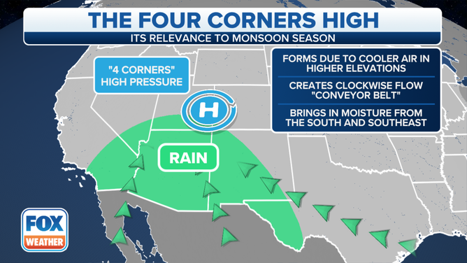
Four Corners High
An area of intense high pressure that sets up around the Four Corners region of the Southwest (where Arizona, New Mexico, Utah and Colorado meet) is known as a "Four Corners High."
(FOX Weather)
NO GOLDEN TICKET REQUIRED: CHOCOLATE FALLS SURGE AFTER MONSOONAL STORMS
This is a classic staple of the summer heat and monsoon season in the Desert Southwest. This ridge can move around the West, but it means abundant sunshine and several days of hot weather.
The Four Corners ridge will help steer moisture into the Southwest from the Gulf of California and trigger their rainy monsoon season in July and August.
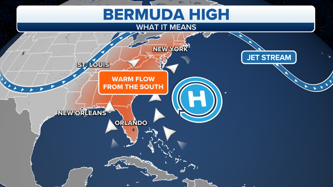
Bermuda High
The Bermuda High is a ridge anchored in the Atlantic Ocean near Bermuda for much of the summer.
BERMUDA HIGH SETS UP OVER 100 RECORD HIGHS IN NORTHEAST
(FOX Weather)
This ridge has a significant effect on hurricane and tropical storm tracks in the Atlantic Ocean and the Gulf of Mexico, depending on the size and location of the high. A minor ridge allows storms to pass up the Eastern Seaboard or curve out to sea, while a stronger ridge that sits farther west will push hurricanes into the Gulf of Mexico. As it transitions to the east in the winter, it becomes known as the Azores High.
North Pacific High
The North Pacific High is a feature in the late spring into summertime in the northern Pacific Ocean. The ridge is a common cause of the "June Gloom" in the San Francisco Bay area. The higher pressure over the cool waters will push marine clouds inland along the West Coast, leaving many days gray and overcast.
PHOTOS: RIVER OF FOG ENGULFS BRIDGE IN CHINA
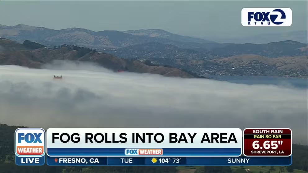
Why is San Francisco so foggy?
Meteorologist Ian Oliver explains the marine layer and why several have said, "the coldest winter I ever spent was a summer in San Francisco."
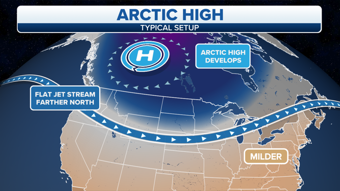
Arctic highs
In the winter, frigid air will drop down from the polar regions into Canada and the United States.
WHERE IS THE NORTH POLE, EXACTLY? IT DEPENDS
(FOX Weather)
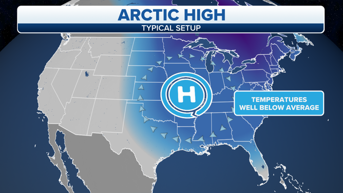
But since cold air is quite dense, it will create its own areas of high pressure -- sometimes known as "Arctic highs," and if it has really cold air, it can bring some of the highest pressure readings you'll see of the year. Arctic highs feature crystal clear skies that allow for frigid overnight temperatures as what little heat the sun gave during the day is radiated out back toward space overnight.
(FOX Weather)
Arctic highs can bring warm - or even hot weather to some areas. These dense Arctic highs that arrive in the autumn to the Intermountain West create conditions for strong Santa Ana and Diablo winds in California.
The Arctic high matches up with lower pressure over central and Southern California to develop strong east/northeast winds that get warmer as they flow down the mountains along eastern California.
Common Low-Pressure Centers:
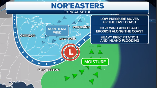
Nor'easter
A Nor'easter describes a powerful low-pressure area that moves up the Eastern Seaboard before curling just off the New England shore.
WHAT MAKES A STORM A NOR’EASTER?
(FOX Weather)
WHAT'S THE DIFFERENCE BETWEEN A NOR'EASTER AND A HURRICANE?
These storms will bring intense winds to the coastal areas with the potential for heavy rains and/or snowfall depending on the storm's track.)
Several Nor'easters have also produced damaging waves along the beaches.
The name comes from the direction of the wind, not the location of the storm. In November 2021, a Nor'easter actually hit the Southeast.
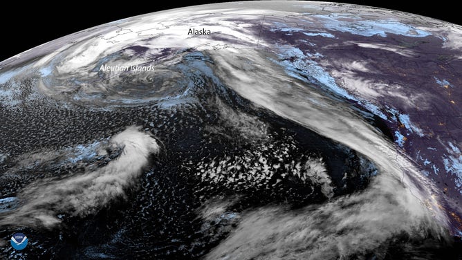
Aleutian Low
According to NOAA, the Aleutian Low is a semi-permanent area of low pressure in the Gulf of Alaska near the Aleutian Islands. It's an area for generating massive storms and is active in the late fall to early spring.
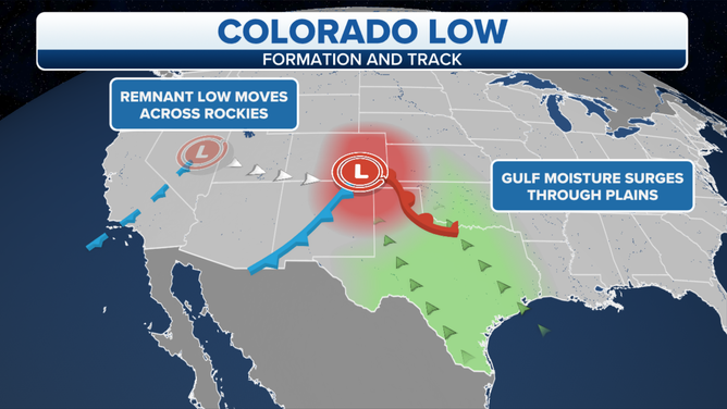
Colorado Low
The Colorado Low is a low-pressure storm system that forms in winter in southeastern Colorado or northeastern New Mexico.
TORNADO ALLEY: 7 THINGS TO KNOW
(FOX Weather)
It tracks northeastward across the central plains of the U.S. over several days, producing blizzards and hazardous winter weather, according to NOAA.
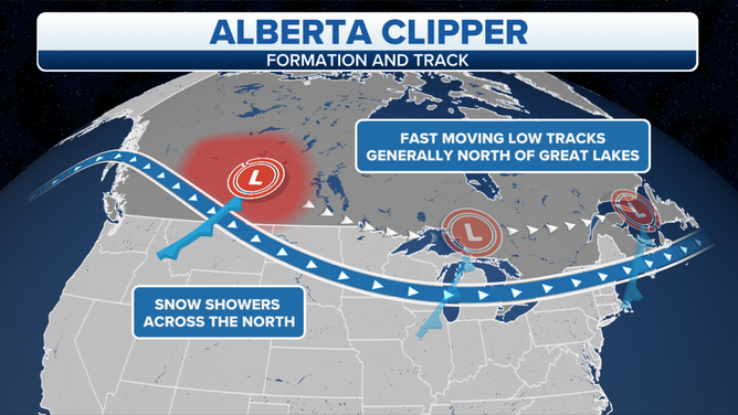
Alberta Clipper/Saskatchewan Screamer/Manitoba Mauler
(FOX Weather)
The "clipper, screamer and mauler" monikers are used to refer to a quick-moving low-pressure area that drops out of Alberta (or Saskatchewan) and races across the upper Midwest and Great Lakes region. These storms are usually suitable for gusty winds, a drop in temperatures, and a few inches of snow.
Lee (Lee-side) low
Lee side lows are low-pressure centers that form on a mountain chain's downwind or lee side. They commonly develop along the east side of the Rockies and/or Sierra Nevada mountains in California or the lee of the Appalachian Mountains in the East. Localized lee-side lows can form around smaller mountains, such as the Olympic Mountains in western Washington.
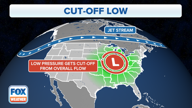
Cut-off Low
There's a saying for these, according to NOAA: "Cut-off low, weatherman's woe."
(FOX Weather)
Cut-offs are persistent low-pressure areas that have become isolated or 'cut-off' from the primary airflow. Why does that bring the "woe" to meteorologists?
"The 'woe' comes for their agonizingly slow motion as they can drift for many days," NOAA says. "While modern weather computer models forecast their drift rather well, they still tend to forecast the closed low pressure to 'open up' and rejoin the main airflow aloft too quickly."
You'll usually find unsettled weather over the eastern half of cut-off lows though there can be some precipitation wrapping around the north end of the low affecting the northwest quadrant of the storm, NOAA says.
When Highs and Lows are stuck together:
Sometimes high and low pressure centers get enjoined and conspire to put a significant roadblock in the movement of weather patterns, resulting in a "blocking" pattern.
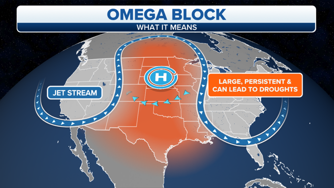
Omega High (Omega Block)
Omega blocks occur when a high-pressure center is flanked by two low-pressure centers on each end, caused when warm air aloft ends up on the northern, cooler side of the jet stream. It’s a very stable pattern that tends to not budge for days. It gets its name from its appearance on upper-air wind charts that steer winds around the lows and highs in the shape of the Greek letter Omega Ω.
WHAT IS AN OMEGA BLOCK PATTERN?
(FOX Weather)
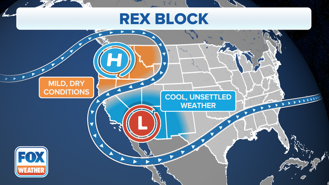
Rex Blocks
Rex blocks are characterized by a high-pressure system essentially sitting on top of a low-pressure system. The two will remain stuck in tandem until one starts to out-muscle the other, at which case the block will break down.
(FOX Weather)
NOAA says that those stuck under the high pressure center can see an extended dry period that could lead to short-term drought. On the other hand, those stuck in the low could see persistent rains that can bring flooding.