What is the jet stream?
Jet streams are narrow bands of strong wind in the upper levels of the atmosphere and follow the boundaries between hot and cold air, according to the National Weather Service.
Commercial flights using power of jet stream to their advantage
Strong winds within the jet stream are helping to get commercial flights from the U.S. to Europe much faster than anticipated. (Video from November 1, 2023)
We often talk about the jet stream at FOX Weather and how it can impact our everyday lives in regard to the weather where we live as well as how it can impact travel – for better or for worse.
But what is the jet stream, and how does the jet stream form?
This article breaks it down.
What is the jet stream? How does the jet stream form?
An animation showing the jet stream between a warm air mass and a cold air mass.
(FOX Weather)
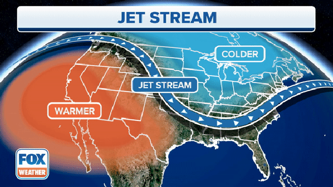
Jet streams are narrow bands of strong winds that usually blow from west to east around the world and form when warm air masses from the south collide with colder air masses from the north in the upper part of the troposphere. There are four main jet streams on Earth - two polar jet streams and two subtropical jet streams, according to NOAA.
Temperatures aren’t the same everywhere in the world. This is most evident during winter when a blizzard paralyzes the Northeast while at the same time, people in South Florida enjoy hot temperatures and spend the day at the beach catching the Sun’s rays.
This is because the Sun doesn’t heat the Earth evenly. Warmer temperatures are found closer to the equator because that part of the planet receives the most direct sunlight. Frigid temperatures are found closer to the north and south poles, because they receive little direct sunlight.
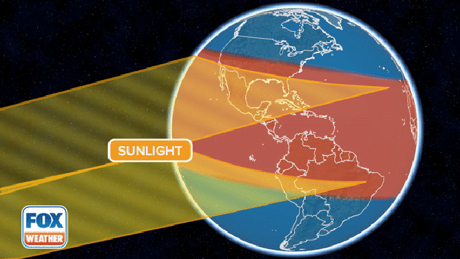
The sun's rays help determine the Earth's temperature.
Heat rises higher into the atmosphere, while cold air sinks closer to the Earth’s surface. The movement of both hot and cold air starts to create a wind current that then leads to a jet stream.
We aren’t talking about a slight breeze, either.
According to NOAA, winds inside the jet stream can move at about 110 mph on average but can vary dramatically depending on the temperature difference between the air masses.
That difference can cause the jet stream to travel much faster – sometimes at speeds of 250 mph or faster.
How does the jet stream impact air travel?
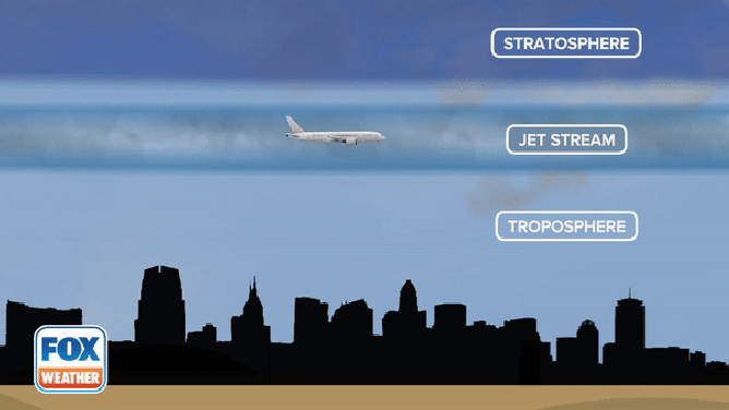
Commercial airlines usually fly between 5-9 miles above Earth's surface and can take advantage of a strong jet stream.
(FOX Weather)
Commercial jets typically fly about 5-9 miles above the surface of the Earth and, on average, fly between 500 and 600 mph.
Typically, a flight from New York City to London is about 7 hours. When a powerful jet stream is screaming across the Atlantic Ocean, pilots can take advantage of that to dramatically reduce flight time.
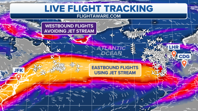
This image shows how commercial flights flying west to east are taking advantage of the jet stream while flights from the east to west are avoiding it.
(FOX Weather)
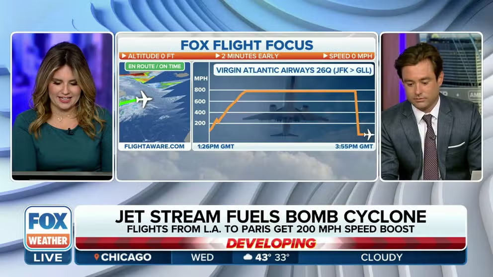
A strong jet stream racing over the Northeast on Nov. 1 has been the key ingredient that's leading to the rapid development of a bomb cyclone that's expected to slam into the United Kingdom and France on Wednesday.
Winds in the atmosphere above Maine reached more than 200 mph on Tuesday, and a weather balloon launched from Caribou, Maine, on Monday night, recorded whipping winds of 206 mph at about 30,000 feet.
Commercial airline pilots took advantage of those wind speeds and have been zooming across the ocean faster than normal.
8 INJURED AFTER FLORIDA-BOUND FLIGHT HITS ‘SEVERE TURBULENCE’
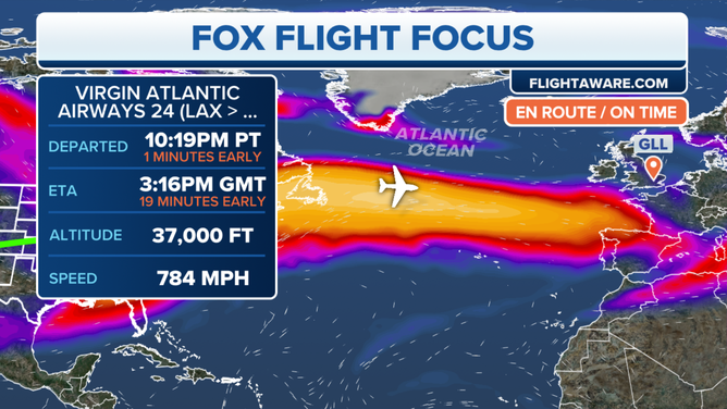
The Fox Flight Focus for Virgin Atlantic flight 24 on Tuesday, October 31, 2023.
(FOX Weather)
In fact, Virgin Atlantic flight 24 from Los Angeles International Airport (LAX) en route to London's Heathrow Airport (LHR) on Tuesday peaked at a speed of 784 mph during the journey. According to FlightAware.com, the flight was able to land 24 minutes early.
Flying from east to west, however, has the opposite effect.
With the powerful jet stream over the Atlantic on Wednesday, commercial flights have been trying to avoid it at all costs in an attempt to avoid strong headwinds, which could lead to delayed arrival times and even severe turbulence.
How does the jet stream affect the weather?
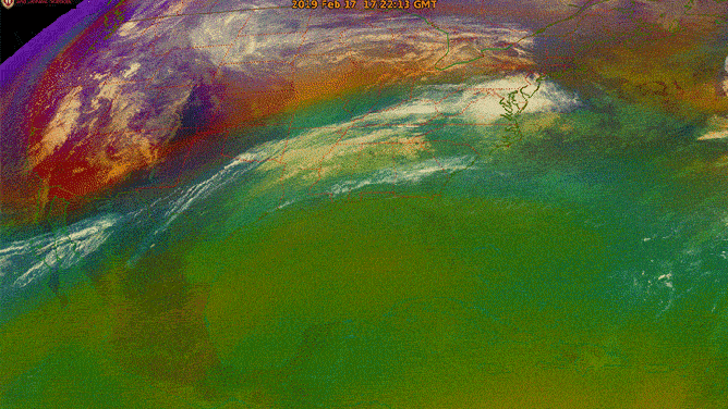
In this image from the GOES-16 (GOES East) satellite, the green area is warm, moist tropical air, while the orange and red areas are cold, dry polar air. The moving band of air between the two is the polar jet stream.
(NOAA/CIMMS/UW-Madison / NOAA)
FOX Weather meteorologists use the jet stream to forecast what the weather is going to do next. It’s not always easy, however, as the jet stream has a reputation for fluctuations.
Those changes can lead to unexpected changes to the forecast, which can have a significant impact on a particular location’s forecast and can mean the difference between a few inches to feet of snow.
Therefore, meteorologists use a variety of satellites to determine where the jet stream is located and where it could be moving.
The jet stream carries weather systems across the U.S., which affect both temperature and precipitation. According to NOAA, if a weather system is located far away from the jet stream, it can stay in one place and lead to extreme weather events like heat waves and floods.
Weather systems usually follow the edge of a jet stream, where the difference between the warm and cold air can create turbulent conditions for storm systems. According to NOAA, the farther south a jet stream is pushed, the warmer and wetter the air will be when the colder air meets up with it. That means a higher chance of thunderstorms and tornadoes.