Screaming jet stream over Northeast will fuel bomb cyclone Ciarán, threatening UK, France with 70-100 mph wind
Wind speeds in the upper atmosphere across Maine are reaching over 200 mph Tuesday, fueled by a large change in temperature over the eastern U.S. A weather balloon launched from Caribou, Maine, Monday night recorded 206-mph winds around 30,000 feet.
Storm Ciaran slams France, England with hurricane-force wind
Gusts reached over 120 mph in France and 100 mph in England as Storm Ciaran blew through the region Thursday.
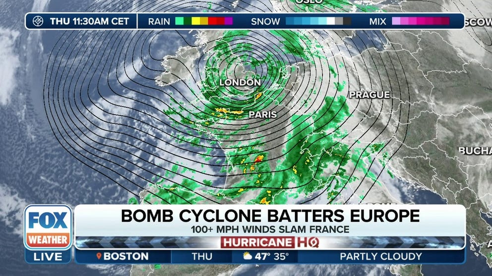
A strong jet stream currently racing over the Northeast is a key ingredient that is leading to the rapid development of a bomb cyclone eyeing France, Ireland and the United Kingdom with damaging wind gusts and torrential rain.
Wind speeds in the upper atmosphere across Maine reached over 200 mph Tuesday, fueled by a large change in temperature over the eastern U.S. A weather balloon launched from Caribou, Maine, Monday night recorded 206-mph winds around 30,000 feet.
How a bomb cyclone forms
The name bomb cyclone comes from the term 'bombogenesis.'
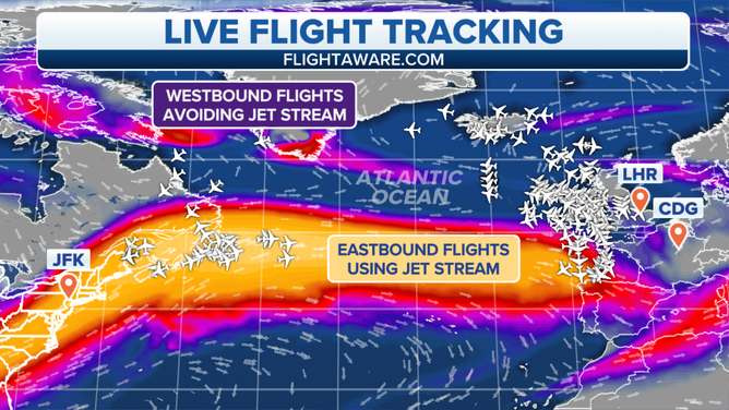
Pilots in the region took advantage of the robust tailwind. The FOX Forecast Center found Air France Flight 79, heading from Los Angeles to Paris Tuesday morning, received a 200-mph boost in ground speed by flying into the heart of the jet stream, moving at 768 mph relative to the ground. The flight would normally expect a ground speed of around 559 mph.

Fast jet stream takes hours off US to UK flight
A screaming jet stream takes up to hours off a U.S. to Europe flight but adds that time on going west. Captain Mike Coffield explains.
Another flight that left Los Angeles bound for London Tuesday night managed to reach 784 mph relative to the ground while over the Atlantic thanks to catching a ride on the jet stream.
Jet streams are narrow bands of strong wind in the upper levels of the atmosphere and follow the boundaries between hot and cold air, according to the National Weather Service. And since that boundary is more pronounced during the winter months, the jet stream is stronger during the winter.
(FOX Weather)
But the jet stream is turning from aviation quirk into fueling a dangerous bomb cyclone quickly developing across the Atlantic Ocean, becoming what the U.K. Met Office is naming Storm Ciarán. The storm remains on track to impact northern Europe through Thursday.
"It's this jet stream barreling out of North America that will pick up Storm Ciarán and intensify it," the U.K. Met Office’s Alex Deakin said in a weather briefing posted on X. "And particularly as we go through Tuesday night and into Wednesday, the storm system crosses the jet stream, and that’s when it really intensifies."
![France Weather Storm Ciaran]() Image 1 of 9
Image 1 of 9A man fishes next to an electronic screen displaying a weather warning message ahead of storm Ciaran on November 1, 2023, in Arcachon, south-western France. France went on high alert as a storm dubbed Ciaran threatened to bring gale-force winds and extreme rainfall to the north and west, as well as Britain and Ireland. (PHILIPPE LOPEZ/AFP)
![France Weather Storm Ciaran]() Image 2 of 9
Image 2 of 9TOPSHOT - Boats anchored at the port are reflected in a puddle of water after heavy rains ahead of storm Ciaran on November 1, 2023, in Arcachon, south-western France. France went on high alert as a storm dubbed Ciaran threatened to bring gale-force winds and extreme rainfall to the north and west, as well as Britain and Ireland. (PHILIPPE LOPEZ/AFP)
![France Weather Storm Ciaran]() Image 3 of 9
Image 3 of 9Closed sea excursion ticket booths are reflected in a puddle of water after heavy rains ahead of storm Ciaran on November 1, 2023, in Arcachon, south-western France. France went on high alert as a storm dubbed Ciaran threatened to bring gale-force winds and extreme rainfall to the north and west, as well as Britain and Ireland. (PHILIPPE LOPEZ/AFP)
![France Weather Storm Ciaran]() Image 4 of 9
Image 4 of 9A woman walks past stairs leading to a puddle of water after heavy rains ahead of storm Ciaran on November 1, 2023, in Arcachon, south-western France. France went on high alert as a storm dubbed Ciaran threatened to bring gale-force winds and extreme rainfall to the north and west, as well as Britain and Ireland. (PHILIPPE LOPEZ/AFP)
![France Weather Storm Ciaran]() Image 5 of 9
Image 5 of 9A child walks in a puddle of water after heavy rains ahead of storm Ciaran on November 1, 2023, in Arcachon, south-western France. France went on high alert as a storm dubbed Ciaran threatened to bring gale-force winds and extreme rainfall to the north and west, as well as Britain and Ireland. (PHILIPPE LOPEZ/AFP)
![France Weather Storm Ciaran]() Image 6 of 9
Image 6 of 9A woman (L) takes a picture of a maritime anchor sculpture ahead of storm Ciaran on November 1, 2023, in Arcachon, south-western France. France went on high alert as a storm dubbed Ciaran threatened to bring gale-force winds and extreme rainfall to the north and west, as well as Britain and Ireland. (PHILIPPE LOPEZ/AFP)
![France Weather Storm Ciaran]() Image 7 of 9
Image 7 of 9A man jogs past closed sea excursion ticket booths reflected in a puddle of water after heavy rains ahead of storm Ciaran on November 1, 2023, in Arcachon, south-western France. France went on high alert as a storm dubbed Ciaran threatened to bring gale-force winds and extreme rainfall to the north and west, as well as Britain and Ireland. (PHILIPPE LOPEZ/AFP)
![France Weather Storm Ciaran]() Image 8 of 9
Image 8 of 9TOPSHOT - A woman holding an umbrella crosses a street under the rain ahead of storm Ciaran on November 1, 2023, in Arcachon, south-western France. France went on high alert as a storm dubbed Ciaran threatened to bring gale-force winds and extreme rainfall to the north and west, as well as Britain and Ireland. (PHILIPPE LOPEZ/AFP)
![France Weather Storm Ciaran]() Image 9 of 9
Image 9 of 9A woman walks past a boat on the foreshore at low tide a few hours before storm Ciaran, in Carantec, western France, on November 1, 2023. (DAMIEN MEYER/AFP)


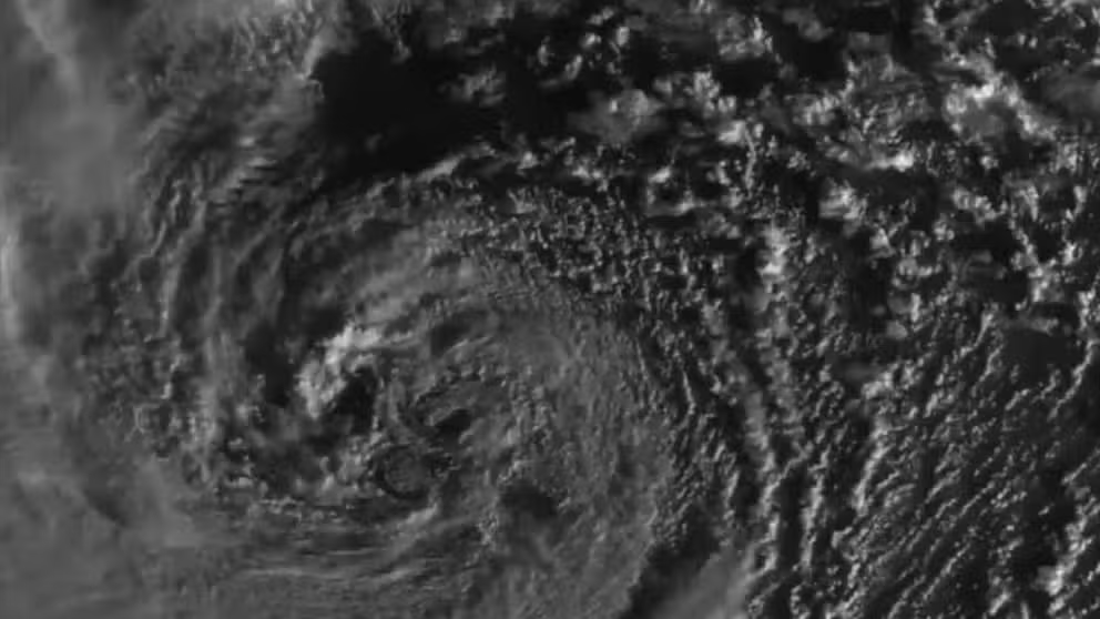
Ciaran's strengthening was already underway Wednesday morning, with the storm's central pressure dropping 17 millibars in 12 hours. Computer forecast models show the storm "bombing out" from about 989 millibars early Wednesday morning to about 952 millibars by early Thursday morning as it approaches Ireland and the U.K. – well within the criteria for a "bomb cyclone," which is a pressure drop of at least 24 millibars within 24 hours.
Amsterdam's Schiphol Airport already announced reduced capacity for the runway due to rough weather Thursday and Friday. KLM started canceling flights in and out.
With the storm center forecast to head up along the English Channel and into southern England late Wednesday into Thursday, High Wind Warnings are in effect across the southern coasts of England, northern areas of France and the western coast of Wales. Predicted gusts are up to 80 to 100 mph along France’s north coasts, 70 to 85 mph along the English Channel and some 65- to 75-mph gusts inland in southwestern England and northern France.
(FOX Weather)
"Very strong northwesterly winds associated with Storm Ciarán could disrupt travel, utilities and may cause some structural damage," the U.K. Met Office warned in its wind alerts.
Point St. Mathieu in Northwest France clocked a wind speed of 91 mph as the monster storm approached. The wind already whipped up impressive waves in France.
HOW TO WATCH FOX WEATHER ON TV

Surfers ride waves at the Grande Plage ahead of storm Ciaran hitting the region, in Biarritz, southwestern France, on November 1, 2023.
(GAIZKA IROZ/AFP / Getty Images)
In addition, heavy rain is forecast across the southern U.K., Ireland and northern France, leading to flash flood worries and rough surf with large seas forecast for the coasts of France.
Ciarán will be a slow-moving storm with impacts lingering into Thursday, followed by calming wind and rain, though unsettled conditions will remain through the end of the week.
Earlier storm slams Northern Ireland
For some parts of the UK, Ciaran is no rest for the weary. Another potent storm struck Northern Ireland earlier in the week, dropping torrential rain and flooding the town of Newry.
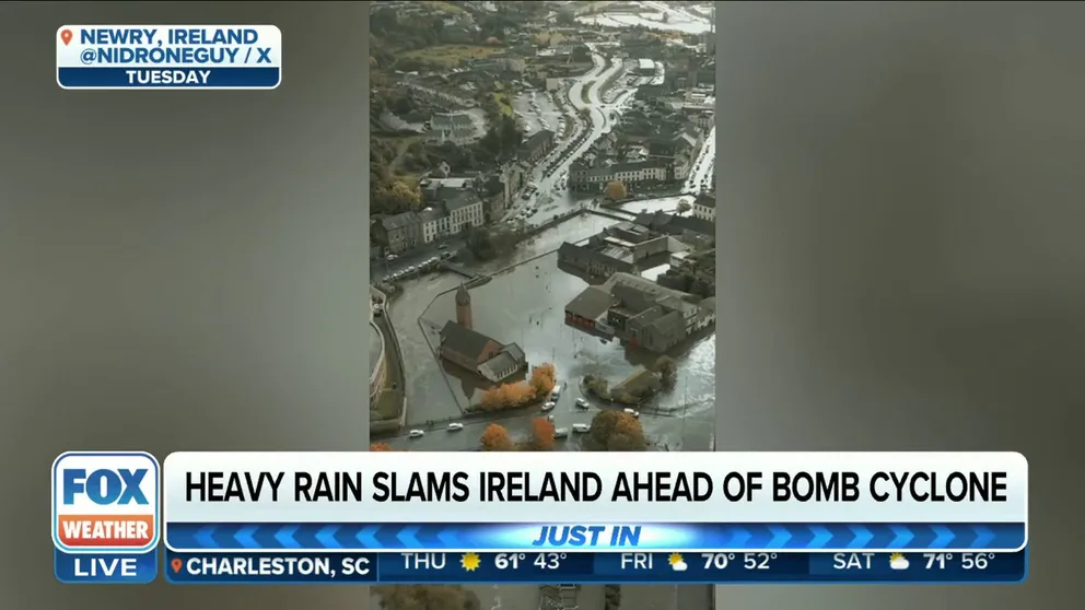
Watch: Drone video of flooding in Northern Ireland ahead of Storm Ciaran
Newry, Northern Ireland sits underwater as drone video shows widespread flooding ahead of Storm Ciaran.
From the Monday evening through Wednesday afternoon, Northern Ireland Fire and Rescue received 384 emergency calls.
Crews rescued five people who waded into the water, 31 people trapped in vehicles and evacuated 12 more from homes ahead of Storm Ciaran.