Daily Weather Update from FOX Weather: New area to watch in Atlantic as Omega block pattern takes hold of US
Top weather news for Thursday, Sept. 11, 2025: The tropical Atlantic has a new area to watch for possible development over the next week. Meanwhile, an Omega block pattern will bring big changes in the weather across the nation.

Weather in America: September 11, 2025
FOX Weather has you covered with the breaking forecasts and weather news headlines for your Weather in America on Thursday, Sept. 11, 2025. Get the latest from FOX Weather Meteorologist Britta Merwin.
Welcome to the Daily Weather Update from FOX Weather. It's Thursday, Sept. 11, 2025. Start your day with everything you need to know about today's weather. You can also get a quick briefing of national, regional and local weather whenever you like with the FOX Weather Update podcast.
Tropical Atlantic springs to life with new area to watch for development off Africa
After a lull in tropical activity as we approached the statistical peak of the 2025 Atlantic hurricane season, forecasters are now monitoring a new area to watch for possible development over the next week.
The National Hurricane Center said environmental conditions could support some slow development over the weekend and into early next week as the tropical wave moves to the west or west-northwest over the eastern and central tropical Atlantic.

(FOX Weather)
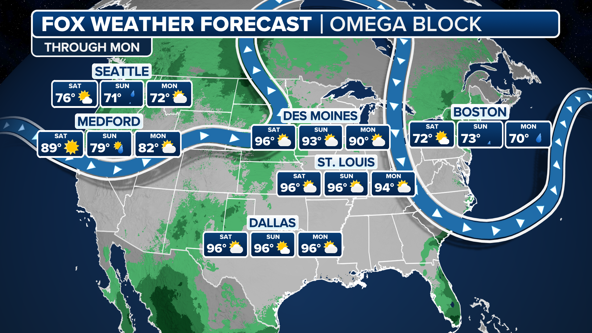
Omega block to bring summer temperatures back to central US, much-needed rain for Pacific Northwest
After a couple of weeks under a stagnant weather pattern, things are finally shaking up across the continental U.S. as an Omega block weather pattern will bring summer temperatures roaring back across the heartland, in addition to much-needed rain for the Pacific Northwest.
An Omega block refers to dips in the jet stream where a large area of high pressure is bookended by two areas of low pressure, causing the pattern to resemble the Greek letter Omega (Ω) on a weather map.
(FOX Weather)
Florida flash flood threat expands as stalled front brings more rain, thunderstorms
The flash flood threat is expanding across portions of Central and South Florida, and more heavy rain and thunderstorms are on the way for Thursday thanks to a stalled cold front loaded with tropical moisture.
Miami has seen more than 8 inches of rain since the end of last weekend, while Orlando, St. Augustine, Daytona Beach and Naples have all picked up more than 5 inches of rain since Sunday.
All that water will maintain an underlying flood threat throughout the week, with parts of the Florida Peninsula in a Level 2 out of 4 flood threat.

(FOX Weather)
Watch this: Lightning strikes tree on Wisconsin lake with massive explosion
The dramatic moment a lightning bolt hit a tree in a Wisconsin backyard, sending bits flying and starting a fire, was caught on camera Tuesday.
The tree sat on the edge of an otherwise peaceful lake in Tomahawk, until a lightning bolt hit the tree out of nowhere with a big crack. An explosion of orange flames and pieces of the tree's bark, limbs and leaves went flying after the lightning made contact.

Watch: Dramatic moment lightning strikes tree in Wisconsin, causing explosion
A bolt of lightning hit a backyard tree in Tomahawk, Wisconsin on Tuesday with a massive crack and explosion, sending pieces of the tree flying and starting a fire within the tree.
Before you go
Here are a few more stories you might find interesting.
- California's Garnet Fire threatens thousands-year-old sequoia trees in Sierra National Forest
- World’s largest iceberg breaks apart over South Atlantic
- NASA seeks new ride to bring potential evidence of Mars life to Earth
Need more weather? Check your local forecast plus 3D radar in the FOX Weather app. You can also watch FOX Weather wherever you go using the FOX Weather app, at FOXWeather.com/live or on your favorite streaming service.