Omega block to bring summer temperatures back to central US, much-needed rain for Pacific Northwest
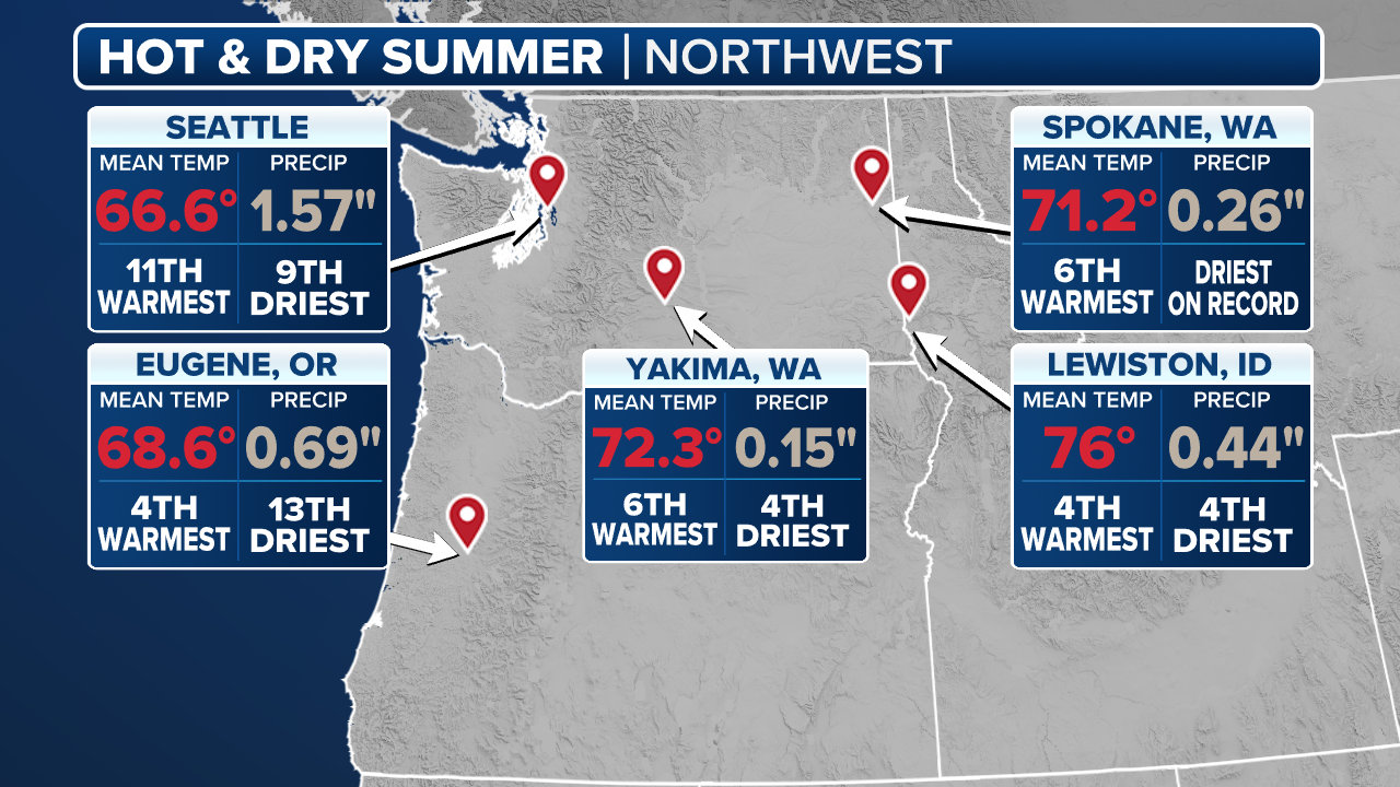
Temperatures across the central U.S. will soar into the 90s beginning Thursday. Meanwhile the Pacific Northwest, which is experiencing one of its top-10 warmest and driest summers on record, will receive much-needed rain.

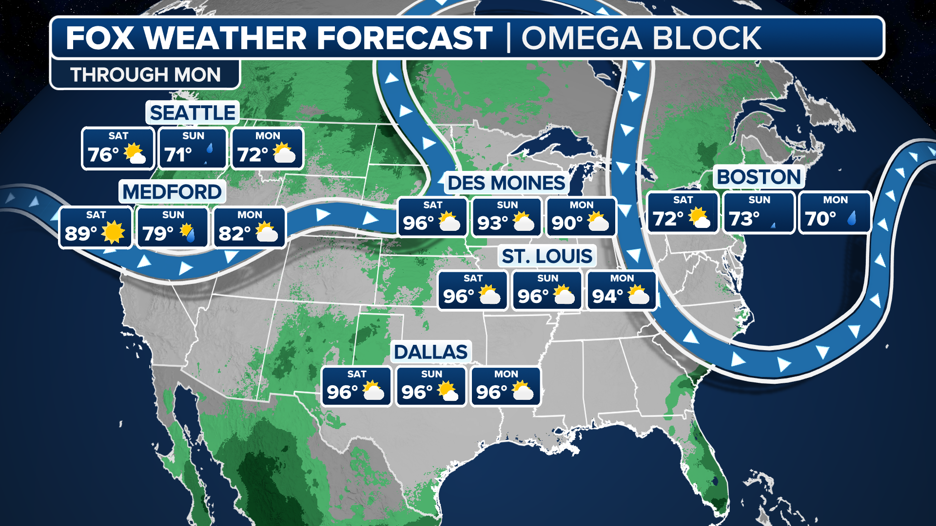
Summer temperatures return to heartland
After a couple of weeks of wet weather and some October-like temperatures, summer will make a comeback Thursday with temperatures in the 90s across the southern Plains and extending as far north as St. Louis, Missouri.
NEW YORK – After a couple of weeks under a stagnant weather pattern, things are finally shaking up across the continental U.S. as an Omega block weather pattern will bring summer temperatures roaring back across the heartland, in addition to much-needed rain for the Pacific Northwest.
An Omega block refers to dips in the jet stream where a large area of high pressure is bookended by two areas of low pressure, causing the pattern to resemble the Greek letter Omega (Ω) on a weather map.
This particular Omega block is beginning to develop late this week as high pressure finally returns to the central U.S., sending temperatures into the 90s, and an area of low pressure brings more intense storms to the Pacific Northwest, which is experiencing one of its top-10 warmest and driest summers on record.
(FOX Weather)
Approaching triple-digit temperatures across parts of central US
After a couple of weeks of wet weather and some October-like temperatures, summer will make a comeback Thursday with temperatures in the 90s across the southern Plains and extending as far north as St. Louis. Even Chicago is expected to approach the 80-degree mark.
By Friday, some 150 million Americans will be experiencing temperatures 10-15 degrees above average, feeling more like the middle of summer. The hot weather will persist through Monday.
The ridge of high pressure building over the middle of the country will send storms from the West tracking along the jet stream into Canada before descending back to the East Coast. Thus, the Northeast will stay slightly cooler than average through Monday.
SEPTEMBER SKYGAZING GUIDE: SATURN SHINES BRIGHT, CORN MOON AND AUTUMNAL EQUINOX

(FOX Weather)
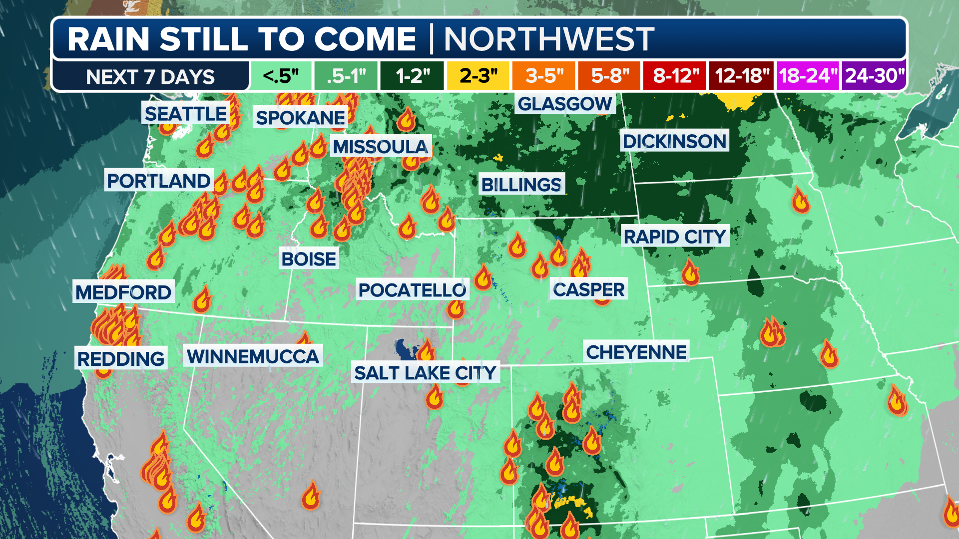
Rain to bring wildfire relief, flash flood threat to Pacific Northwest
Parts of the Pacific Northwest are already seeing some rain, but a second, more intense round of storms will move into the region Thursday as the Omega block weather pattern takes shape.
This rain will be beneficial for much of the Northwest, which is in drought, according to the U.S. Drought Monitor. The region as a whole is experiencing one of its top-10 driest and warmest summers on record.

Omega Block weather pattern to bring much-needed rain to drought-stricken Northwest
The Pacific Northwest is experiencing one of its top-10 warmest and driest summers. Wildfires have been burning with little to no containment with the smoke blanketing the region for days on end. The region will see rain through the weekend which should help boost firefighting efforts.
A Level 1 out of 4 flash flood risk has been issued by NOAA's Weather Prediction Center across much of the Northwest and northern Rockies through Sunday morning. A widespread 1-2 inches of rain is expected through the weekend.
A Flood Watch is in place now across portions of Oregon, with the possibility of debris flows due to excessive rain over recent burn scars.
Parts of the northern Rockies and northern Plains have been placed under a Level 2 out of 5 risk of severe weather Thursday, according to NOAA's Storm Prediction Center. This includes parts of Montana and North Dakota.
LIGHTNING STRIKES, DRY CONDITIONS SPARK DOZENS OF NEW BLAZES IN CALIFORNIA
(FOX Weather)
Wildfires, many of which have been caused by dry lightning, are burning across the region with little to no containment due to the dry conditions.
Smoke from these fires has created air quality issues for Washington, Oregon, Idaho, Montana and Wyoming at varying points this summer.
According to the FOX Forecast Center, the rainy weekend should help boost firefighting efforts.
(FOX Weather)
The precipitation will likely be too far north to help quell the Garnet Fire, which prompted Dense Smoke Advisories for parts of Central California and Nevada earlier this week.