Satellite images give unique perspective of disasters from space in 2023
Maxar Technologies has continuously provided jaw-dropping satellite images that were taken miles above areas impacted by disasters.
Before-and-after satellite images show scope of Vermont flooding
Satellite images taken before and after flooding in Vermont on Tuesday show the true scope of devastation left behind.
The world has been rocked by extreme weather and geological events that have dominated the headlines since the start of 2023.
We’ve repeatedly observed scenes of destruction from the ground, whether it be homes ripped apart by powerful tornadoes, thick, black wildfire smoke that turned day into night, buildings being washed downstream due to rushing floodwaters or winds whipping through communities as they were being ravaged by hurricanes.
Those scenes are no doubt heartbreaking, and FOX Weather has been committed to bringing you stories of triumph and survival in the wake of devastating disasters.
But when scenes of destruction are seen in satellite images taken high above the Earth’s surface, the magnitude of what has taken place is given a whole new perspective.
Maxar Technologies has continuously provided jaw-dropping satellite images taken miles above areas impacted by disasters.
Here are some notable events as seen from space that took place in 2023.
Hurricane Otis pummels Acapulco, Mexico
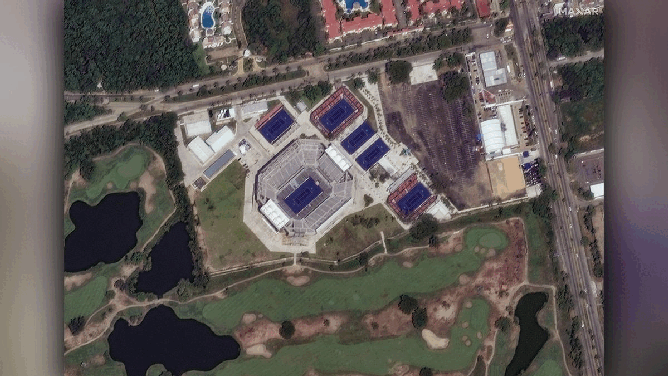
![Before and after shots of Arena GNP Seguros Stadium in Acapulco, Mexico, show impact of Hurricane Otis in October 2023.]() Image 1 of 7
Image 1 of 7Before and after shots of Arena GNP Seguros Stadium in Acapulco, Mexico, show impact of Hurricane Otis in October 2023. (Satellite image ©2023 Maxar Technologies)
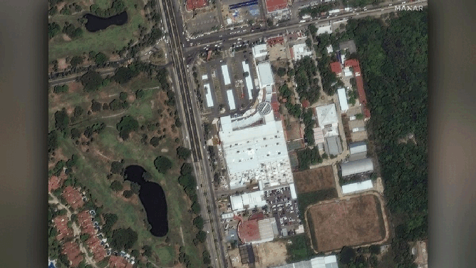
![Before and after shots of a shopping mall in Acapulco, Mexico, show impact of Hurricane Otis in October 2023.]() Image 2 of 7
Image 2 of 7Before and after shots of a shopping mall in Acapulco, Mexico, show impact of Hurricane Otis in October 2023. (Satellite image ©2023 Maxar Technologies)
![Before and after shots of boats in a marina in Acapulco Bay, Mexico, show impact of Hurricane Otis in October 2023.]() Image 3 of 7
Image 3 of 7Before and after shots of boats in a marina in Acapulco Bay, Mexico, show impact of Hurricane Otis in October 2023. (Satellite image ©2023 Maxar Technologies)
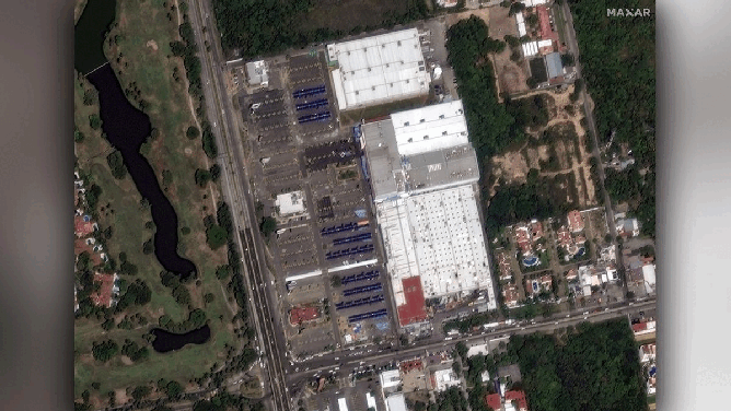
![Before and after shots of Walmart supermarket and Sam’s Club warehouse in Acapulco, Mexico, show impact of Hurricane Otis in October 2023.]() Image 4 of 7
Image 4 of 7Before and after shots of Walmart supermarket and Sam’s Club warehouse in Acapulco, Mexico, show impact of Hurricane Otis in October 2023. (Satellite image ©2023 Maxar Technologies)
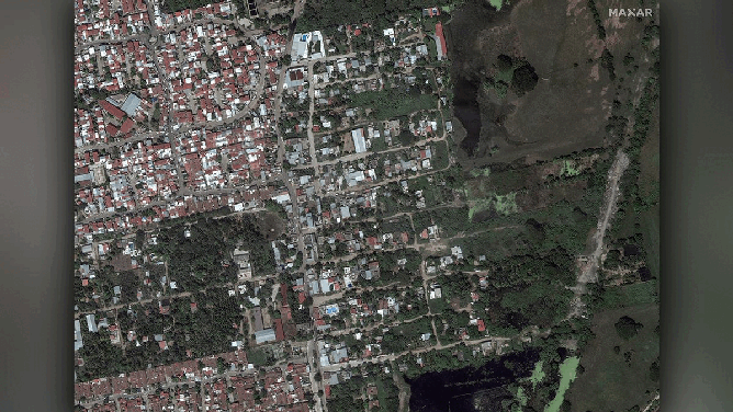
![Before and after shots of the La Poza neighborhood in Acapulco, Mexico, show impact of Hurricane Otis in October 2023.]() Image 5 of 7
Image 5 of 7Before and after shots of the La Poza neighborhood in Acapulco, Mexico, show impact of Hurricane Otis in October 2023. (Satellite image ©2023 Maxar Technologies)
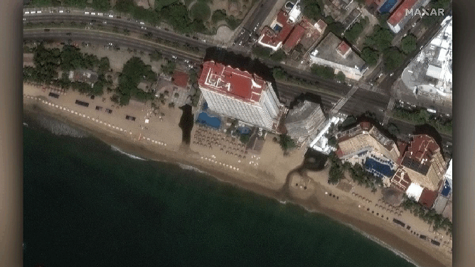
![Before and after shots of the Krystal hotel and beachfront in Acapulco, Mexico, show impact of Hurricane Otis in October 2023.]() Image 6 of 7
Image 6 of 7Before and after shots of the Krystal hotel and beachfront in Acapulco, Mexico, show impact of Hurricane Otis in October 2023. (Satellite image ©2023 Maxar Technologies)
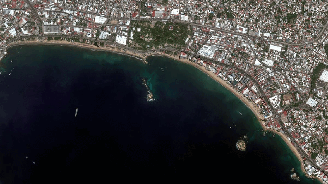
![Before and after shots of Acapulco Bay, Mexico, show impact of Hurricane Otis in October 2023.]() Image 7 of 7
Image 7 of 7Before and after shots of Acapulco Bay, Mexico, show impact of Hurricane Otis in October 2023. (Satellite image ©2023 Maxar Technologies)

Hurricane Otis dominated the headlines in October after the hurricane made landfall near Acapulco, Mexico.
The "nightmare scenario" began when the storm experienced nearly unprecedented explosive development in a matter of hours, strengthening from a Category 1 to a catastrophic Category 5 hurricane, catching about 1 million people in the storm’s path off-guard.
HOW DID HURRICANE OTIS' RECORD INTENSIFICATION CATCH ADVANCED FORECAST MODELS BY SURPRISE?
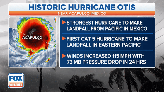
A graphic showing what made Hurricane Otis' landfall near Acapulco, Mexico, historic.
(FOX Weather)
Dozens of people were killed, and widespread damage was reported across the region, with several hotels in the popular travel destination of Acapulco receiving significant damage.
Before-and-after satellite images from Maxar Technologies showed the scope of the disaster, from flooded stadiums to boats destroyed in Acapulco Bay to coastlines that have forever been changed.
Hurricane Otis is now the most powerful hurricane to ever strike the Pacific coast of Mexico.
Hell on Earth: Deadly wildfires rage around the world
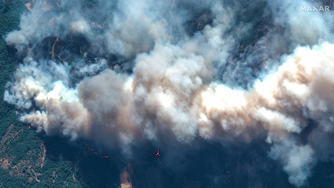
A satellite photo showing thick smoke from a wildfire in Alexandroupolis, Greece.
(Satellite image ©2023 Maxar Technologies)
It wasn’t only extreme weather events that were in the headlines in 2023.
Extreme temperatures, drought and a changing climate are being blamed on deadly wildfires that scorched tens of millions of acres of land around the world.
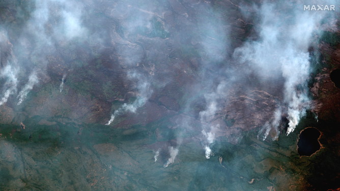
A satellite image showing wildfires near Dogface Lake in Canada.
(Satellite image ©2023 Maxar Technologies)
Canada saw the bulk of wildfire activity in 2023, with Natural Resources Canada saying at least 6,623 fires scorching more than 45 million acres of land across all provinces.
In August, wildfires forced the evacuation of 20,000 people living in the Northwest Territories capital city of Yellowknife.
Several wildfires also erupted across Quebec, with many blamed on lightning strikes from severe weather that produced thunderstorms across the province.
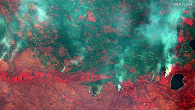
A satellite image showing wildfires near Dogface Lake in Canada.
(Satellite image ©2023 Maxar Technologies)
Satellite images show fires raging out of control near Dogface Lake in the Northwest Territories, sending smoke billowing into the air. Images shared by Maxar Technologies show red areas, which is indicative of a lush landscape against dark areas, which is what was left after flames burned the area.
A satellite image showing wildfires near Dogface Lake in Canada.
(Satellite image ©2023 Maxar Technologies)
The flames weren't the only danger, either. Smoke from the thousands of wildfires in Canada was blown thousands of miles and entered the U.S. as well as across the Atlantic Ocean into Europe.
In June, New York City and many major cities in the eastern U.S. saw the sky turn an eerie orange color as smoke blocked out the Sun. In addition, New York City experienced the worst air quality recorded in its history.
Deadly fires ravage Europe
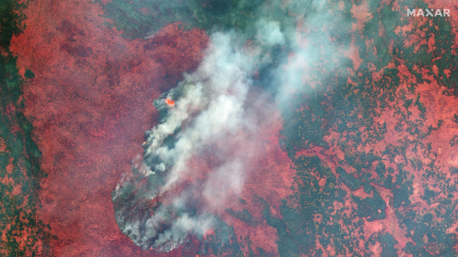
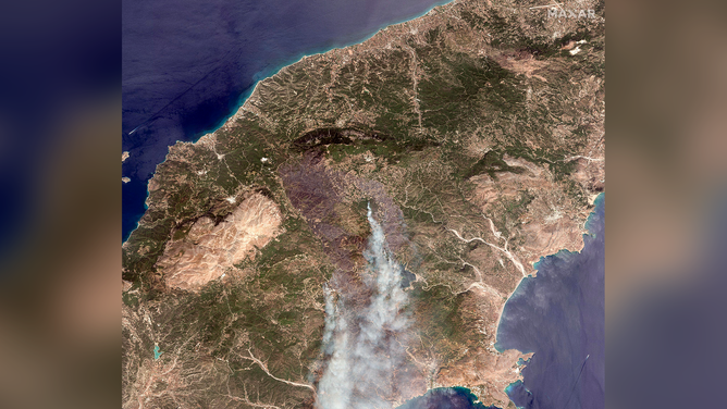
A satellite image showing wildfires on the Greek island of Rhodes.
(Satellite image ©2023 Maxar Technologies)
Europe, too, saw its fair share of wildfires this year, with notable blazes burning out of control in places like Spain, Italy and Greece.
Greece was hit especially hard by wildfires.
A satellite image showing wildfires on the Greek island of Rhodes.
(Satellite image ©2023 Maxar Technologies)
Thousands of people were forced to flee the Greek island of Rhodes as fires raged across the region while temperatures soared this summer.
Hundreds of firefighters on the ground and in the air worked to contain and extinguish the fires, and thousands of acres went up in flames.
On the island of Evia, a terrifying video showed a firefighting airplane that crashed when the wing of the airplane clipped some trees and caused it to plunge into a mountain. The two people on board were killed.
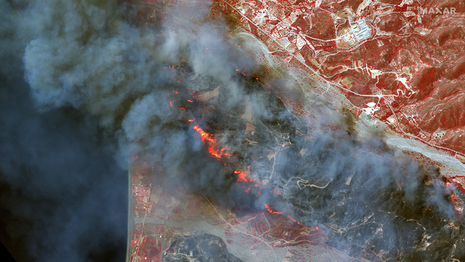
A satellite image showing wildfires in Alexandroupolis, Greece.
(Satellite image ©2023 Maxar Technologies)
Firefighters from across Europe flocked to Greece to help in the firefighting efforts, all while thousands of people quickly tried to escape the advancing flames. Numerous flights to Greece were canceled, and instead, those airplanes were used to safely evacuate residents and tourists to other locations while the fires continued to burn.
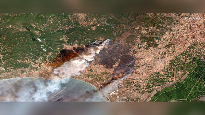
A satellite image showing wildfires in Palermo, Italy.
(Satellite image ©2023 Maxar Technologies)
Satellite images also showed fires burning across Sicily in Italy as temperatures soared above 100 degrees.
A Maxar Technologies image showed thick smoke billowing above the Italian city of Palermo in Sicily.
Hawaii experiences deadliest wildfire in modern US history
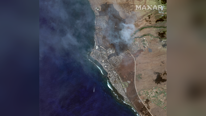
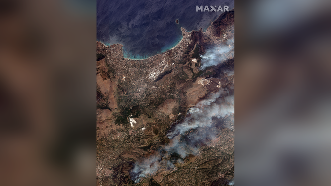
A satellite image showing wildfires in Lahaina, Hawaii.
(Satellite image ©2023 Maxar Technologies)
In August, Hawaii experienced the deadliest wildfire in modern U.S. history when at least 100 people were killed in the town of Lahaina on the island of Maui.
The wildfires on Maui occurred due to a combination of a few atmospheric conditions.
BEFORE-AND-AFTER SATELLITE IMAGES OF MAUI AFTER DEADLY WIND-DRIVEN BRUSH FIRES
Hurricane Dora was spinning to the south of the Hawaiian islands, and dry conditions and a strong ridge of high pressure to the north helped to provide the 70-mph wind gusts that allowed the flames to rage out of control once they were ignited.
Despite the National Weather Service in Honolulu issuing Fire Weather Warnings for the islands in the run-up to the fires, emergency management didn't use all the tools to warn residents of the unfolding disaster.

A satellite image showing wildfires in Lahaina, Hawaii.
(Satellite image ©2023 Maxar Technologies)
Maui County officials said outdoor warning sirens were not used to warn residents because they said they were afraid that residents would have fled uphill toward the flames rather than toward the ocean to safety.
Residents were allowed to start returning to their homes one month after the disaster.
East Coast, West Coast rocked by historic flooding
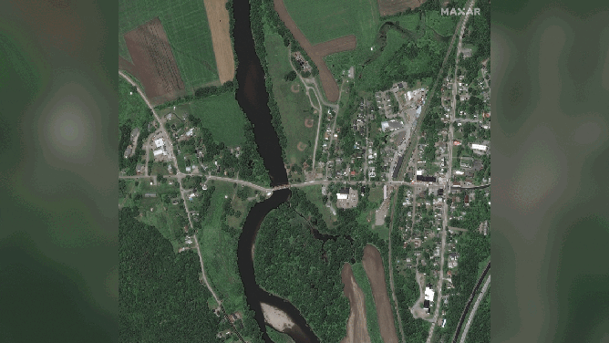
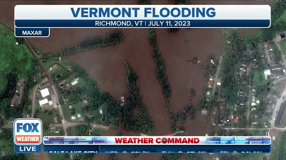
Before-and-after images show the flooding of the Winooski River in Vermont.
(Satellite image ©2023 Maxar Technologies)
Vermont saw record-breaking flooding in July, with several rivers and creeks spilling out of their banks during a flash flood event.
The flooding even prompted fears that water levels at a dam would flow into an emergency spillway, sending water rushing downstream.
The city manager of Montpelier issued a warning that water could have started to rush into the already-flooded state capital and turn it into a potentially dangerous situation.
During the event, Vermont experienced the worst flooding since Hurricane Irene in 2011. Numerous roads were closed across the region, and several people needed to be rescued from the fast-moving water.

Before-and-after images showing flooding in Palm Springs, California.
(Satellite image ©2023 Maxar Technologies)
Hurricane Hilary slammed into California over the summer, which led to crippling flooding in Palm Springs.
Before-and-after photos showed the aftermath of the flooding, which led to a local emergency after the flooding overwhelmed the city.
Palm Springs received more than a half-year's worth of rain in less than a day. The National Weather Service recorded 2.64 inches daily, and the city averages 0.14 inches of rain each August and only 4.61 inches yearly.