Before-and-after satellite images of Maui after deadly wind-driven brush fires
The combination of Hurricane Dora and a ridge of high pressure helped enhance fire weather throughout the islands.
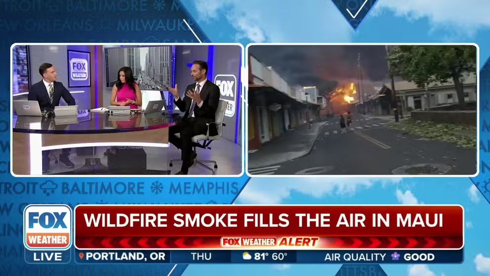
Widespread damage reported as bush fires overwhelm authorities in Hawaii
At least six people were killed during wind-driven fires across the Hawaiian Islands.
KAHULUI, Hawaii – The scope of the brush fires that have impacted nearly all inhabited islands of the Hawaiian chain are being seen by satellite imagery.
Maxar, a space technology company based in Colorado, released images Wednesday that showed devastation across Maui, with hundreds of homes and businesses that were destroyed.
The deadly fires engulfed the community of Lahaina, destroying nearly everything in sight.
"Nobody was prepared for this…Local people have lost everything. They’ve lost their house, they’ve lost their animals. And it’s devastating," said James Tokioka, the director of the Department of Business, Economic Development and Tourism.
AERIAL VIDEO SHOWS COMPLETE DEVASTATION ACROSS PARTS OF MAUI AFTER CATASTROPHIC BRUSH FIRES
![Aerial View of Lahaina on the Coast of Maui]() Image 1 of 4
Image 1 of 4Aerial View of Lahaina on the Coast of Maui (Satellite image ©2023 Maxar Technologies)
![Aerial View of Lahaina on the Coast of Maui]() Image 2 of 4
Image 2 of 4Aerial View of Lahaina on the Coast of Maui (Satellite image ©2023 Maxar Technologies)
![Aerial View of Lahaina on the Coast of Maui]() Image 3 of 4
Image 3 of 4Aerial View of Lahaina on the Coast of Maui (Satellite image ©2023 Maxar Technologies)
![]() Image 4 of 4
Image 4 of 4Aerial View of Lahaina on the Coast of Maui (Douglas Peebles/Corbis via Getty Images/Richard Olsten/Facebook)


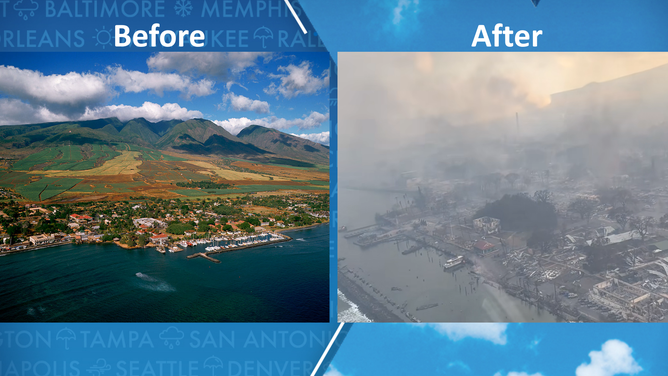
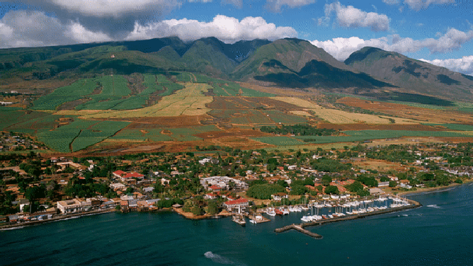
The first imagery Maxar released was before and after photos of Lahaina’s Banyan Court area.
The government considers the spot a historic site and is home to arts and other societies.
Before the fire, visitors could see the island’s oldest living Banyan Tree, which was estimated to be over 150 years old.
The area is located near the harbor, where the Coast Guard responded to reports that people were wading through the ocean in an attempt to escape the flames.
In the before photo taken on June 25, the harbor was full of boats, and green trees dotted the landscape with several structures.
After the fire, there were fewer boats in the marina, nearly every tree was browned or destroyed, and except for less than a handful of buildings, very few structures remain.
Lahaina Banyan Court area. The before image is from June 25, 2023 and the after is from August 9, 2023.
(Satellite image ©2023 Maxar Technologies / FOX Weather)
AT LEAST 36 DEAD FROM RAGING BRUSH FIRES BOOSTED ENHANCED BY HURRICANE DORA, HIGH PRESSURE
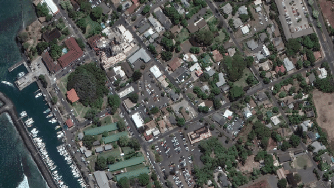
In the second pair of images, Maxar concentrated on the historic buildings that make up the town of Lahaina.
Lahaina used to be the capital of the Kingdom of Hawaii during the 1800s before being annexed by the U.S. as a territory.
The district was designated as a National Historic Landmark by the National Park Service in 1962.
Significant damage was done throughout the area except for a few properties that immediately butt up against the ocean.
Aerial View of Lahaina on the Coast of Maui
(Satellite image ©2023 Maxar Technologies / FOX Weather)
‘THIS IS NOT A SAFE PLACE TO BE’: RAGING BRUSH FIRES IMPACTING AIR TRAVEL TO SOME HAWAIIAN ISLANDS
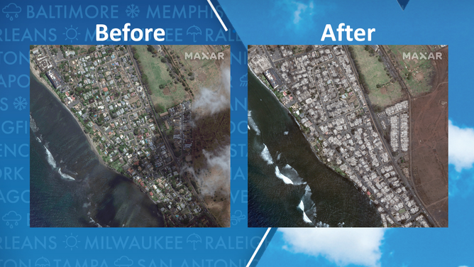
The third set of satellite images showed the Lahaina Square Shopping Center area on June 25 and then again on August 9.
Before the fires, the shopping center was full of local vendors and was about a block off the beach.
The picture taken after the brush fire rolled through showed complete devastation to the shopping destination and a billowing tower of black smoke from a building in the commercial district.
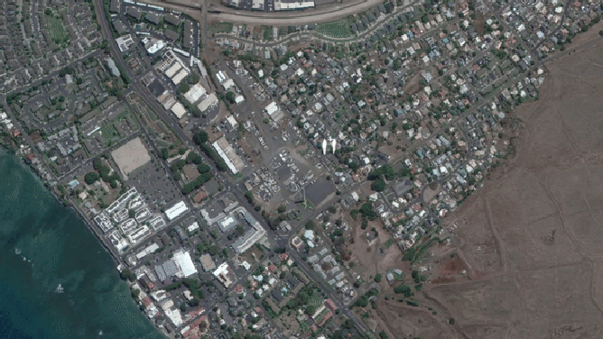
Lahaina Square Shopping Center area. Before image: June 25, 2023, after image: August 9, 2023.
(Satellite image ©2023 Maxar Technologies / FOX Weather)
According to the Maui County government, an initial assessment determined more than 271 structures were either damaged or destroyed in Lahaina.
Officials have not said when they believe they’ll have the brush fires under control or when residents will be able to return to personally assess the damage.
For the latest coverage of the deadly Hawaiian brush fires: Click here.
Aerial View of Lahaina on the Coast of Maui
(Douglas Peebles/Corbis via Getty Images / FOX Weather)