How did Hurricane Otis' record intensification catch advanced forecast models by surprise?
"This was not a case where some computer forecasts showed a powerful storm, and others said it would be weak, so forecasters took the middle ground," said FOX Weather Hurricane Specialist Bryan Norcross. "Not one fancy, modern computer model showed the off-the-charts rapid intensification."
'This is shocking': FOX Weather hurricane specialist Bryan Norcross breaks down Hurricane Otis' explosive intensification
FOX Weather hurricane specialist Bryan Norcross spoke with FOX Weather meteorologist Amy Freeze on Wednesday morning to break down what went wrong with the official forecast with Hurricane Otis ahead of its historic landfall near Acapulco, Mexico, on Wednesday, October 25, 2023.
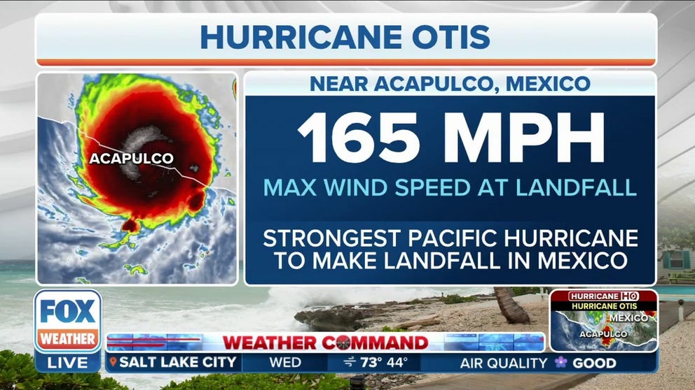
As Hurricane Otis swirled north toward Mexico's Pacific coastline Tuesday, a "nightmare scenario" unfolded for residents near Acapulco when the storm experienced nearly unprecedented explosive development in hours, going from a Category 1 to a catastrophic Category 5 with nearly no warning, stunning residents and meteorologists alike.
Suddenly, 1 million people were in the path of the strongest storm to ever strike the Pacific coast of Mexico and left with only hours to prepare. While these days computer forecast models typically give residents days of warning before life-threatening conditions arrive, Otis fooled them all.
"This was not a case where some computer forecasts showed a powerful storm, and others said it would be weak, so forecasters took the middle ground," said FOX Weather Hurricane Specialist Bryan Norcross. "Not one fancy, modern computer model showed the off-the-charts rapid intensification."
Otis would gain an incredible 115 mph in strength in just 24 hours between 1 a.m. Tuesday to Wednesday, supercharging from a 50-mph tropical storm to a 165-mph Category 5 monster.
WHAT DOES IT MEAN WHEN A HURRICANE UNDERGOES ‘RAPID INTENSIFICATION’?
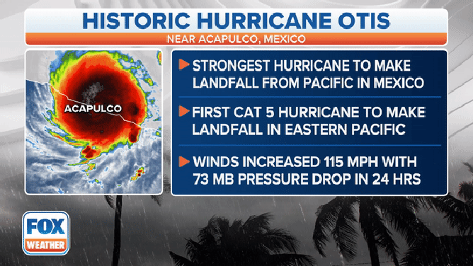
Norcross said Otis’ strength and northerly track into the city of Acapulco had never been witnessed before, as no hurricanes on record have ever been close to Otis' intensity for this part of Mexico. The only storm on a similar track to impact that part of Mexico was in 1951, and that was a Category 1.
A graphic showing what made Hurricane Otis' landfall near Acapulco, Mexico, historic.
(FOX Weather)
"This is completely out of bounds, in terms of forecasting," Norcross said. "The computer models completely missed this pattern of a super conducive atmosphere, and the (storm) direction and so forth being so different from anything that has occurred in the last 50 or 60 years."
Hurricane Warnings were already in effect for Acapulco. But even as of late Tuesday morning, Otis was forecast to make landfall with peak winds of 90 mph – rating a Category 1. Luckily, the NHC had sent Hurricane Hunter aircraft into the storm and was alarmed to find the hurricane already stronger than forecast – and quickly getting even stronger.
HOW ARE HURRICANES RATED? THE SAFFIR-SIMPSON HURRICANE WIND SCALE EXPLAINED
"At this point, we’re still trying to piece together exactly what's happened in the last 12-24 hours," NHC director Michael Brennan told FOX Weather Wednesday. "You know, we were lucky. We had aircraft reconnaissance in the storm (Tuesday) afternoon to give us an idea of how quickly Otis was starting to intensify, because that wasn't really apparent in the satellite imagery."
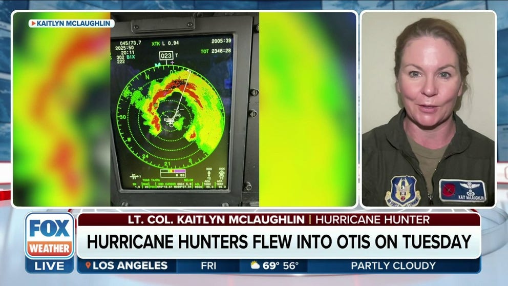
Even the crew on the Hurricane Hunter flight were surprised.
"We thought it was a tropical storm at the time, and we assumed it would be a hurricane by the time we actually left, but that’s not exactly what we found at all," Lt. Col. Kaitlyn McLaughlin, who was on the Hurricane Hunter flight, told FOX Weather. "As we were going in, I knew before we actually penetrated the eye wall that we were looking at at least a (Category) 2 (hurricane)."
McLaughlin said their data is transmitted to the NHC in near real time, allowing forecasters there to immediately get an updated picture on Otis' rapid intensification.
"So we were able to increase our intensity forecast by late Tuesday to show a Category 4 hurricane at landfall," Brennan said.
Hurricane Hunter describes rapid intensification in Otis
Lt. Col. Kaitlyn McLaughlin, a 53rd WRS Aerial Reconnaissance Weather Officer, joined FOX Weather and described the rapid intensification she saw in Otis.
Soon, the NHC noticed the storm continued to rapidly intensify "at a really unprecedented or a nearly unprecedented rate, matching or even exceeding the rate that (Hurricane) Patricia in 2015 intensified in the Pacific, which has really been the highest we've seen up to that point," Brennan said.
INSIDE THE FLYING LABORATORY USED BY NOAA'S HURRICANE HUNTERS
By Tuesday night, NHC's forecast indicated Otis was now expected to reach catastrophic Category 5 status. Otis would make landfall after 1 a.m. local time with 165-mph winds – the strongest storm ever to make landfall in the Eastern Pacific Ocean.
How did the forecast models miss this?
Norcross said he believes there were three main factors in play that caused the models to miss such a catastrophic development.

Listen to the wind howl as Otis tears through Acapulco, Mexico
Hurricane Otis made landfall near Acapulco, Mexico, as a Category 5 storm early on Wednesday, bringing maximum sustained winds of up to 165 mph. Listen to the winds as the powerful storm rock Mundo Imperial Hotel.
"One is that it was a very small hurricane," Norcross said, comparing the storm’s relatively small width to Hurricane Charley in 2004 that hit just north of Fort Myers, Florida. "Small hurricanes blast the coast in a narrow area, and when they hit a populated area, they do a tremendous amount of damage. But the computer models don't analyze them as well, because the details in a small hurricane count so much because everything is so small, you know, so tiny, like you need a magnifying glass, this to get all the details."
A second factor was a nearby dip in the jet stream that affected the storm’s development.

Watch: Category 5 Hurricane Otis makes landfall in Acapulco, Mexico
Hurricane Otis rapidly intensified from a tropical storm to a dangerous Category 5 hurricane within 12 hours before hitting Mexico's southern Pacific coast. Video shows a view from the Mundo Imperial Hotel in Acapulco as Otis made landfall early Wednesday morning.
"If the jet stream gets too close to the storm, it pulls the system apart with hostile upper winds," Norcross said. "If it's close but not too close, it can pull air out of the top of the hurricane in a very efficient way, which causes the storm to intensify if all the other environmental conditions are ideal."
Third, was a very warm patch of water right off the coast of Acapulco.
"It's over 86 or 88 degrees, more or less, just offshore of Acapulco in a relatively small patch that this hurricane just happened to track over," Norcross said. "No doubt, that was part of it as well. And because that patch was small, whether that was well-analyzed and whether that data was appropriately in the computer models, that's an open question."
WHAT IS THE 'CONE OF UNCERTAINTY' IN HURRICANE FORECASTS?
As to how the forecast models could be so dramatically off that the forecast one day ago would have such a large error: "The reality is there's going to be research for an extended period of time," Norcross said.
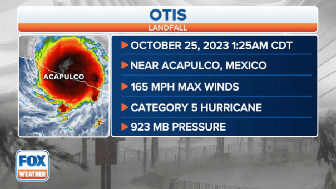
A graphic showing information on Hurricane Otis' historic landfall near Acapulco, Mexico, on Oct. 25, 2023.
(FOX Weather)
Brennan told FOX Weather his agency will certainly go back and try to figure out how to avoid such surprises in the future.
"We'll go back and look at the post-analysis of this storm like we do from every other one and try to piece together what happened," Brennan said. "You know, we don't have a lot in terms of (weather) observations. We see pictures like you've been showing, but we’ll take some time to piece together what actually happened and how strong Otis was when it made landfall. Certainly, we can take that information and go back to the modeling community, the research community, and try to help the group forecasts going forward."