Hurricane Otis makes historic Category 5 landfall in Mexico near Acapulco
Otis is the strongest hurricane to ever make landfall in Mexico and the first time an Eastern Pacific hurricane has ever made landfall at Category 5 intensity.
Hurricane Otis shatters tropical records as it tears into Mexico as Category 5 storm
Otis came ashore at Acapulco with catastrophic wind speeds of 165 mph, making the hurricane the strongest storm to make landfall in the eastern Pacific on record.
A "nightmare scenario" is underway in Mexico after Hurricane Otis made its historic landfall as a Category 5 hurricane. Our live coverage of Hurricane Otis has moved to this link.
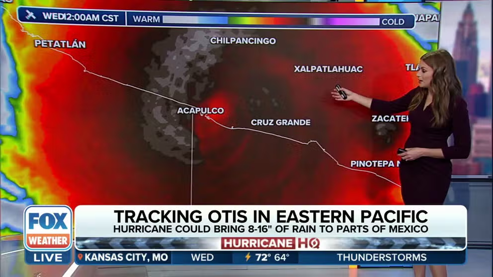
Hurricane Otis rapidly intensified into a catastrophic Category 5 hurricane Tuesday as it approached the southern coast of Mexico, where it made a historic landfall overnight near Acapulco.
The National Hurricane Center (NHC) said Otis made landfall just 5 miles south of Acapulco around 1:25 a.m. CDT Wednesday as a Category 5 hurricane packing destructive winds of 165 mph. Otis was the strongest hurricane to ever make landfall on the Pacific side of Mexico. It was also the first time an Eastern Pacific hurricane made landfall at Category 5 intensity.

(FOX Weather)
"A nightmare scenario is unfolding for southern Mexico this evening with rapidly intensifying Otis approaching the coastline," the National Hurricane Center warned in its forecast discussion Tuesday night after Otis intensified at an explosive rate. "… This is an extremely serious situation for the Acapulco metropolitan area with the core of the destructive hurricane likely to come near or over that large city early on Wednesday. There are no hurricanes on record even close to this intensity for this part of Mexico."
The NHC said catastrophic damage was likely where the hurricane's core moved onshore. Otis was forecast to bring a "potentially catastrophic" storm surge with "life-threatening" coastal flooding, huge waves, destructive winds and flooding rainfall to southern Mexico.
"Hurricane Otis has intensified by 80 mph in the past 12 hours (from 65 mph to 145 mph)," Colorado State University hurricane specialist Phil Klotzbach wrote on X (formerly Twitter) Tuesday evening when the storm intensified to a Category 4 hurricane. That's the fastest 12-hour intensification rate in the eastern North Pacific (to 180°) in the satellite era (since 1966), breaking the old record of 75 mph/12 hours set by Patricia in 2015."
What's the latest with Hurricane Otis?

(FOX Weather)
As of early Wednesday morning, Hurricane Otis is centered about 25 miles north-northwest of Acapulco, Mexico, and is moving north-northwest at 10 mph. Otis is still Category 4 hurricane with maximum sustained winds of 130 mph.
Damaging hurricane-force winds will spread inland over southern Mexico Wednesday morning, with extremely destructive winds near the core of Otis during the next few hours.
A Hurricane Warning remains in effect along the southern coast of Mexico from Punta Maldonado westward to Zihuatanejo, including the city of Acapulco.

(FOX Weather)
Rapid weakening is expected as Hurricane Otis moves inland over the higher terrain of Mexico. Otis will likely dissipate over southern Mexico Wednesday night, the NHC said.
WHICH HURRICANES RAPIDLY INTENSIFIED BEFORE US LANDFALL?
Where is Hurricane Otis going?

(FOX Weather)
The NHC said Otis will track toward the north-northwest through Wednesday night and continue to move inland across southern Mexico until it dissipates.
Otis is expected to produce rainfall totals between 8 and 16 inches, with maximum amounts up to 20 inches, through Thursday across the state of Guerrero and the western coastal sections of Oaxaca. This rainfall will produce flash and urban flooding, along with mudslides in higher-terrain areas.
Another disturbance could develop south of Central America, Mexico
According to the NHC, a broad area of low pressure will likely form in a day or two over the far Eastern Pacific, partially related to the remnants of former Atlantic Tropical Depression Twenty-One.
Environmental conditions should be conducive for some development of this system, and a tropical depression could form late this week or this weekend while the low moves slowly westward to west-northwestward.
The NHC is giving it a medium chance of development over the next five days.

(FOX Weather)