Vermont sees catastrophic flash flooding with impacts not seen since Hurricane Irene in 2011
NOAA's Weather Prediction Center placed most of Vermont and portions of northeastern New York under a rare "high risk" of excessive rainfall – the first high risk issued for Vermont since August 2011 during Hurricane Irene.
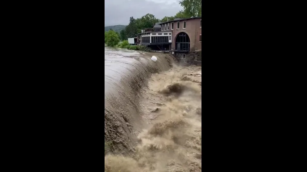
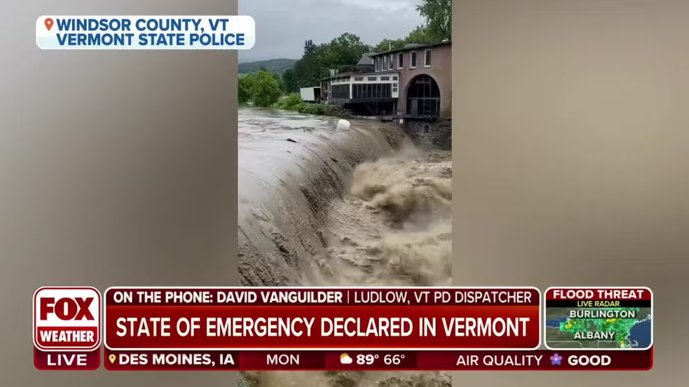
Watch: Dramatic video shows raging floodwaters spilling over Vermont dam
Vermont State Police are warning people to stay off the roads and stay safe at the state faces potentially catastrophic flash flooding on Monday. Video from VSP shows raging water flowing over a dam on the Ottauguechee River near Simon Pearce in Quechee.
MONTPELIER, Vt. – The state of Vermont faced catastrophic flash flooding that hadn't been seen in the region since Hurricane Irene in 2011, according to the National Weather Service.
This threat comes after deadly and historic flooding was reported in New York's lower Hudson Valley on Sunday. At least one person was killed, and numerous water rescues were conducted after torrential rain caused rivers and streams to overflow their banks, leading to roadways being washed away. The NWS issued a Flash Flood Emergency for parts of Orange, Putnam, Rockland and Westchester counties due to the catastrophic flooding.
Flooding in Vermont on Monday led to dozens of state road closures and water rescues throughout Monday.
"Vermont’s swift water rescue teams have now performed more than 50 rescues, primarily in the towns of Londonderry, Weston, Bridgewater, Andover, Ludlow, and Middlesex," officials said Monday evening.
WHY RARE ‘HIGH RISK’ FLOOD DAYS NEED TO BE TAKEN SERIOUSLY
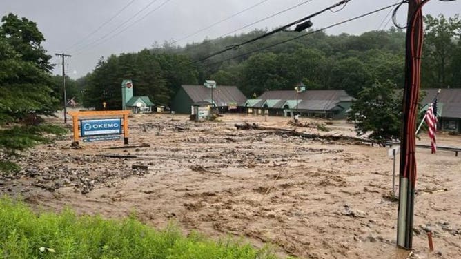
![A photo showing devastating flooding near the Okemo Ski Resort in Ludlow, Vermont, on Monday, July 10, 2023.]() Image 1 of 12
Image 1 of 12A photo showing devastating flooding near the Okemo Ski Resort in Ludlow, Vermont, on Monday, July 10, 2023. (@shanemcandrew/Twitter)
![A photo showing water covering a road in Ludlow, Vermont, on Monday, July 10, 2023. The state faces potentially catastrophic flash flooding on Monday.]() Image 2 of 12
Image 2 of 12A photo showing water covering a road in Ludlow, Vermont, on Monday, July 10, 2023. The state faces potentially catastrophic flash flooding on Monday. (Alisha Durgin)
![Raging floodwaters cover a road in Ludlow, Vermont, on Monday, July 10, 2023.]() Image 3 of 12
Image 3 of 12Raging floodwaters cover a road in Ludlow, Vermont, on Monday, July 10, 2023. (@AJShelto /Twitter)
![Water rushes down a hill after torrential rain in New York on Sunday, July 9, 2023.]() Image 4 of 12
Image 4 of 12Water rushes down a hill after torrential rain in New York on Sunday, July 9, 2023. (MTA/Twitter)
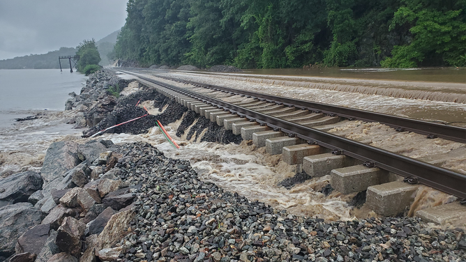
![This image shows water covering railroad tracks in New York state on Sunday, July 9, 2023. Flooding was reported across the lower Hudson Valley after torrential rain.]() Image 5 of 12
Image 5 of 12This image shows water covering railroad tracks in New York state on Sunday, July 9, 2023. Flooding was reported across the lower Hudson Valley after torrential rain. (MTA/Twitter)
![A tree is seen across railroad tracks in New York state on Sunday, July 9, 2023.]() Image 6 of 12
Image 6 of 12A tree is seen across railroad tracks in New York state on Sunday, July 9, 2023. (MTA/Twitter)
![Mud and debris covers railroad tracks in New York state on Sunday, July 9, 2023.]() Image 7 of 12
Image 7 of 12Mud and debris covers railroad tracks in New York state on Sunday, July 9, 2023. (MTA/Twitter)
![New York flooding]() Image 8 of 12
Image 8 of 12Rockland County- Palisades Interstate Parkway flooding. (New York State Police)
![Flooding around West Point in New York]() Image 9 of 12
Image 9 of 12Flash flooding around West Point in New York (West Point Garrison and Community)
![Richlandtown water rescue]() Image 10 of 12
Image 10 of 12Richlandtown, PA water rescue (Richlandtown Fire Co.)
![New York flooding]() Image 11 of 12
Image 11 of 12Rockland County- Palisades Interstate Parkway flooding. (New York State Police)
![Flooding around West Point in New York]() Image 12 of 12
Image 12 of 12Flash flooding around West Point in New York (West Point Garrison and Community)


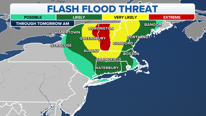
First ‘high risk’ for flash flooding in Vermont since Hurricane Irene in 2011
Forecasters say multiple rounds of moderate to heavy rain will soak portions of Vermont in New England, as well as parts of northeastern New York state. Up to 5 inches of rain was seen throughout the state, with some spots recording more than 7 inches.

(FOX Weather)
NOAA's Weather Prediction Center (WPC) has placed most of Vermont and portions of northeastern New York under a rare "high risk" of excessive rainfall – the first high risk issued for Vermont since August 2011 during Hurricane Irene.
When a high risk – the highest risk level that can be issued – is in place, it means severe, widespread flash floods are expected in the highlighted areas.
A map showing the flash flood threat through Tuesday, July 11, 2023.
(FOX Weather)
High risks are only issued on about 4% of days (including tropical and non-tropical events), but this risk category accounts for 39% of flood-related fatalities and 83% of flood-related damages in the continental U.S., according to research by WPC meteorologists.
"Expect significant to potentially catastrophic widespread flash flooding through Monday evening, with possible impacts not seen since (Hurricane) Irene," the National Weather Service office in Burlington, Vermont, warned in a forecast discussion early on Monday.
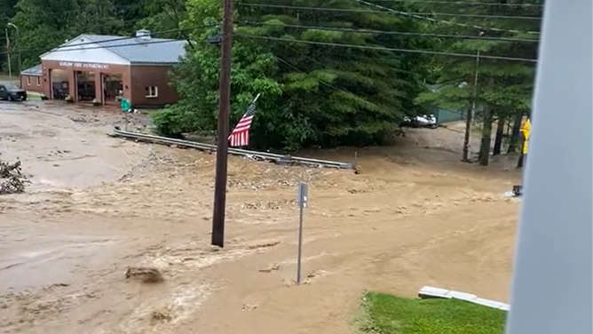
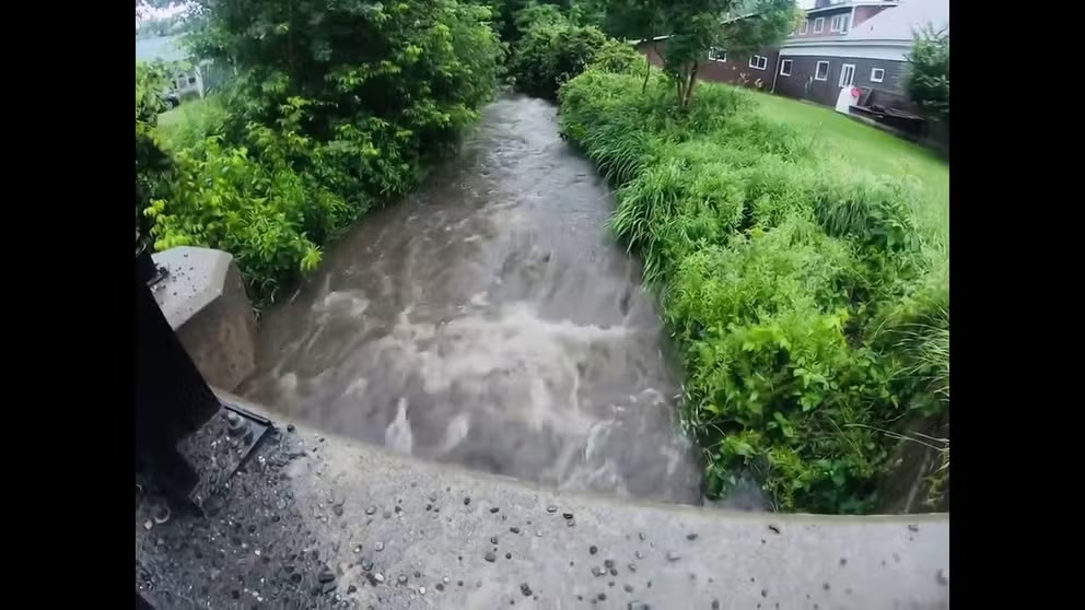
Flooding cuts off access to Ludlow, Vermont
Police in Ludlow, Vermont, say devastating flooding has washed away roads and left many other impassable cutting off access to the town.
Irene produced a wide swath of 5 to 8 inches of rain across Vermont, which led to devastating mudslides and deadly flooding.
Cities under the WPC's high risk for flash flooding include St. Albans, Burlington, Montpelier, Middlebury, Rutland, Manchester and Woodford in Vermont. Plattsburgh in New York is also included in the high-risk area through Tuesday morning.
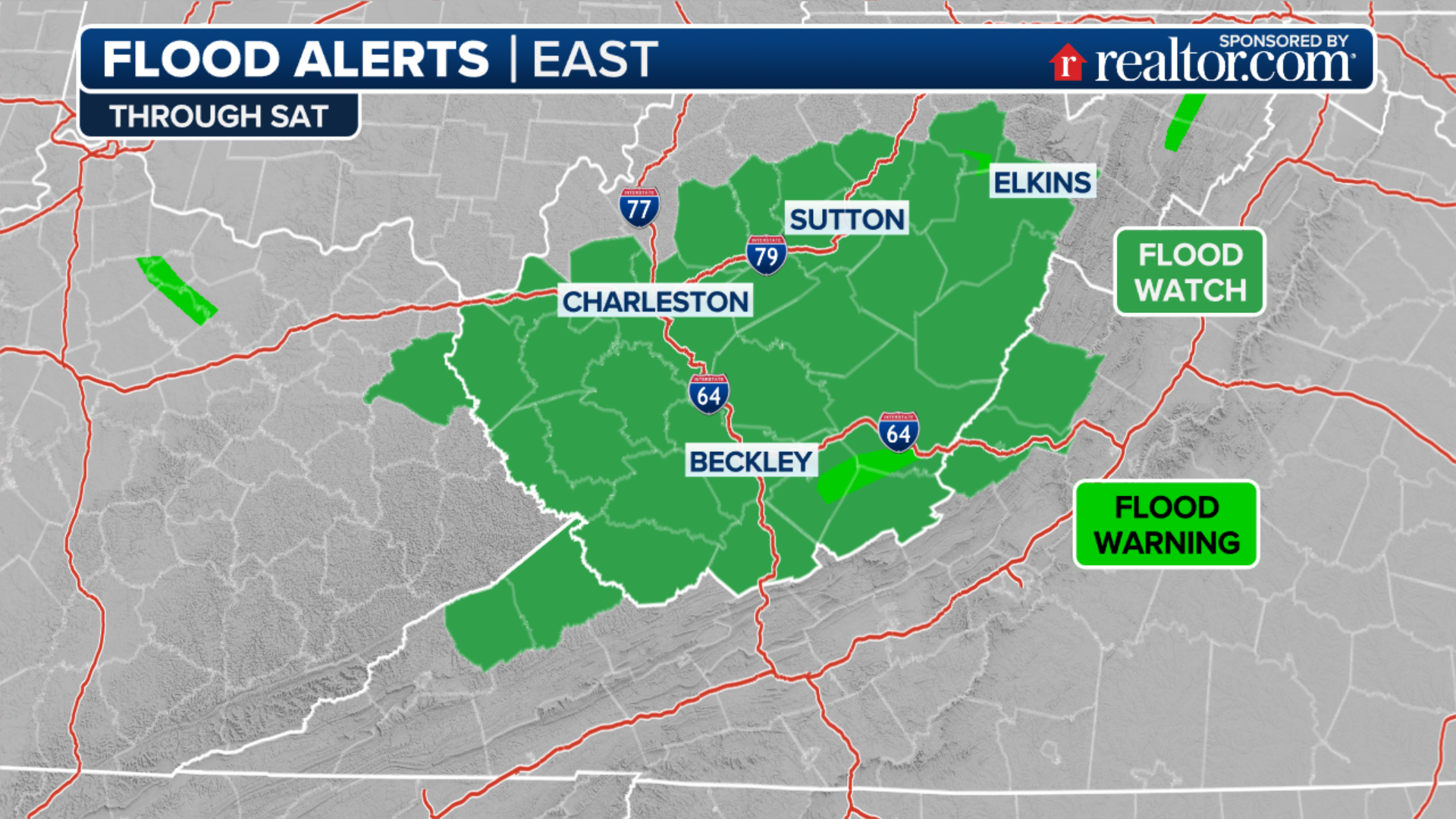
Flood Watches were issued across New England and in parts of the Northeast through at least Tuesday afternoon.
(FOX Weather)
The Flood Watches stretch from portions of northwestern Maine through New Hampshire, Vermont, western Massachusetts, Rhode Island and Connecticut in New England. Eastern New York state is also included in the Flood Watch.
A Flash Flood Emergency was issued for portions of central Vermont through Monday afternoon, and more Flash Flood Warnings are likely to be issued across the region throughout the day and into Tuesday.
On Monday, nearly the entire state of Vermont was placed under a Flash Flood Warning.
Flood threat leads to state of emergency in Vermont
Because of the risk of torrential rainfall, Vermont Gov. Phil Scott declared a state of emergency.
Watch: Major flooding reported in Montpelier, Vermont
Video posted to Facebook by the Vermont Agency of Agriculture shows the Winooski River rushing downstream as torrential rain leads to flash flooding statewide.
"The State Emergency Operations Center has been activated, and the Department of Public Safety, Agency of Transportation and other state agencies and departments will be working overnight and throughout Monday and beyond to assist cities and towns in their response," Scott said in a tweet on Sunday.
Londonberry-resident Dana Zazinski said she first realized the flooding was dangerous when firefighters knocked on her door and suggested she move her car because the West River was encroaching on her driveway.
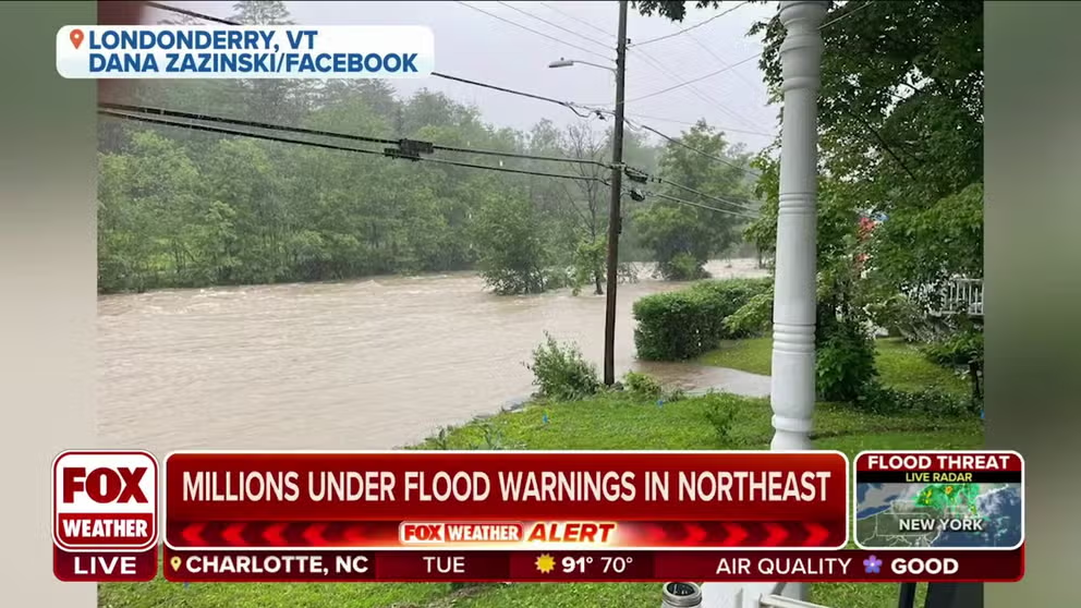
'Pretty scary:' Vermont resident describes flood water approaching her home
Dana Zazinski, of Londonderry, Vermont described watching as the West River has slowly approached her home during ongoing flooding. "This is pretty scary," Zazinski told FOX Weather.
"I'm not going to lie. This is pretty scary," Zazinski said.
The torrential rain is also leading to the rise of rivers in Vermont, some of which could reach major flood stage.

(FOX Weather)
The Winooski River was expected to reach its second-highest level on record at 19.8 feet - which is about a foot higher than it rose when Hurricane Irene impacted the area.
Forecasters with NWS Burlington expect Winooski River at Montpelier to crest in the major flood category late Monday night.
Vermont emergency managers urged Montpelier residents who live in low-lying areas to make a plan to protect family, pets and belongings.

(FOX Weather)
Officials urged residents to stay home
Emergency officials urged residents to stay off the roads if possible and to use extreme caution if travel is unavoidable.
Vermont State Police said emergency crews have been conducting water rescues in several communities, and about two dozen roads have been closed across the state.
Watch: Dramatic video shows raging floodwaters spilling over Vermont dam
Vermont State Police are warning people to stay off the roads and stay safe at the state faces potentially catastrophic flash flooding on Monday. Video from VSP shows raging water flowing over a dam on the Ottauguechee River near Simon Pearce in Quechee.
"Make an evacuation plan before it becomes necessary," state police said on Twitter. "Do not drive or walk through floodwaters. The water can obscure washouts, carry debris and strong currents, and be deeper than it appears."