Deadly floodwaters receding in Vermont after near-historic river crests topped only by Great Flood of 1927
Catastrophic flooding continued Tuesday in Vermont after up to 9 inches of rain fell in parts of the state, sending rivers to crests higher than Hurricane Irene levels in August 2011 and topped only by the Vermont flood of 1927 – the greatest natural disaster in the state's history.
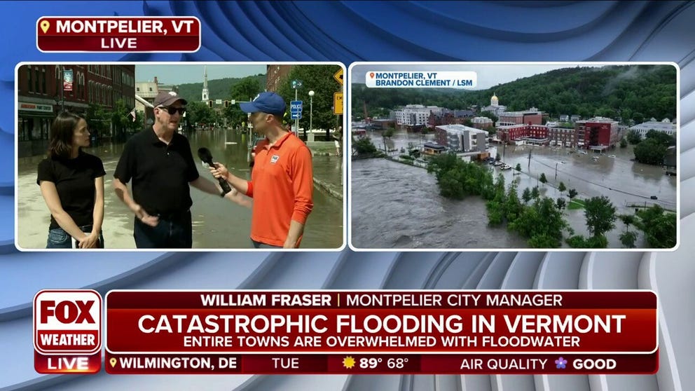
Montpelier City Manager: Flooding Is 'Definitely Worst Than Irene'
William Fraser and Kelly Murphy, City Manager and Assistant City Manager of Montpelier, VT, respectively, joined FOX Weather's Ian Oliver to discuss the flooding across their city.
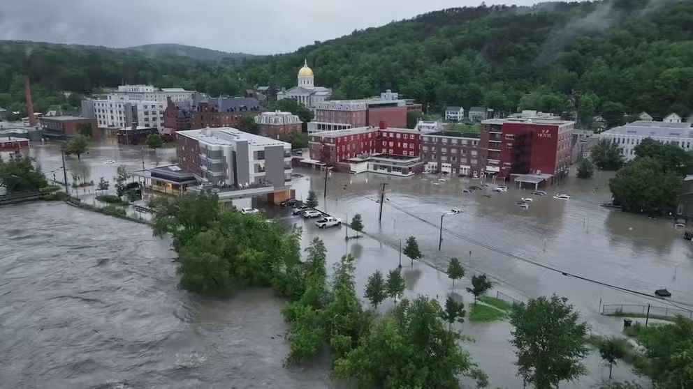
MONTPELIER, Vt. – Water levels at a dam in Vermont appeared to have peaked Tuesday just hours after Montpelier’s city manager issued an ominous warning alerting residents that the site could reach capacity and spill over, sending large amounts of water rushing into the state’s already-flooded capital and turning it into a "potentially dangerous situation."
Early Tuesday morning, emergency managers said the Wrightsville Dam had risen 3 feet above record levels and had only 6 feet of storage capacity remaining. As the hours ticked by, the Montpelier Police Department said in a Facebook post that the dam continued to inch closer to the top, coming within a few feet of the spillway.
But by Tuesday evening, town officials said water levels had receded, and a breach was no longer anticipated.
VERMONT'S LATEST FLOODING DISASTER APPROACHES LEVELS NOT SEEN SINCE THE GREAT FLOOD OF 1927

(FOX Weather)
Emergency managers worried about the scale of disaster if the dam were to have been breached.
"This has never happened since the dam was built, so there is no precedent for potential damage," Montpelier city manager William Fraser warned in the Facebook post. "There would be a large amount of water coming into Montpelier, which would drastically add to the existing flood damage."
Fraser said the situation would have been most dire along the North Branch River corridor and into the downtown area.
![Heavy Rains Cause Catastrophic Flooding In Vermont]() Image 1 of 40
Image 1 of 40MONTPELIER, VERMONT - JULY 11: Main Street is flooded on July 11, 2023 in Montpelier, Vermont. Up to eight inches of rain fell over 48 hours and residents were warned that Wrightsville Dam could reach capacity, forcing it to release more water that could impact the downtown area. (Photo by Kylie Cooper/Getty Images)
![]() Image 2 of 40
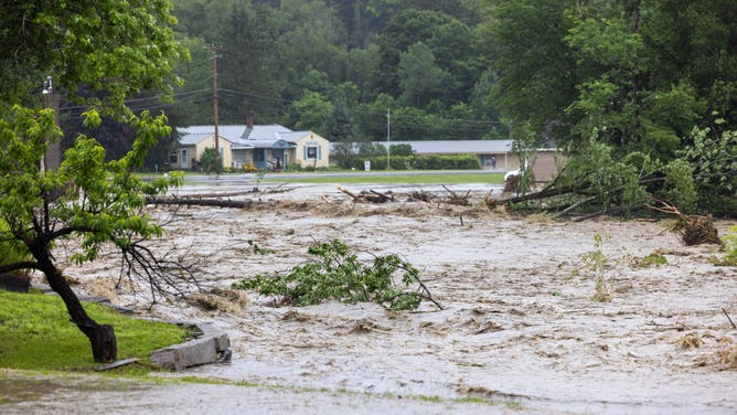
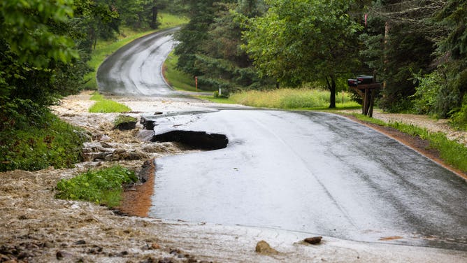
Image 2 of 40WINDHAM, VERMONT - JULY 10: A road is severely damaged by flooding on July 10, 2023 in Windham, Vermont. Torrential rain and flooding has affected millions of people from Vermont south to North Carolina. (Photo by Scott Eisen/Getty Images) ( )
![]() Image 3 of 40
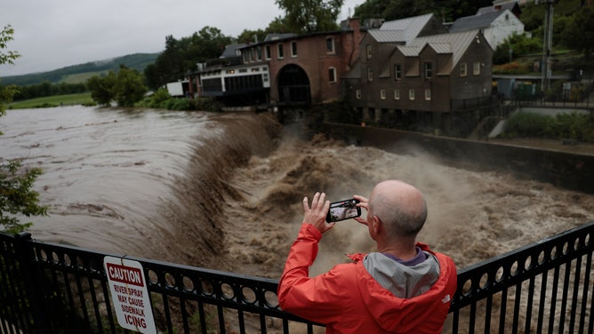
Image 3 of 40Quechee, VT - July 10: Heavy rain sends mud and debris down the Ottauquechee River. (Photo by Jessica Rinaldi/The Boston Globe via Getty Images) ( )
![]() Image 4 of 40
Image 4 of 40Quechee, VT - July 10: A man stops to take a photo as heavy rain sends mud and debris down the Ottauquechee River. (Photo by Jessica Rinaldi/The Boston Globe via Getty Images) ( )
![]() Image 5 of 40
Image 5 of 40Quechee, VT - July 10: A man watches as heavy rain sends mud and debris down the Ottauquechee River. (Photo by Jessica Rinaldi/The Boston Globe via Getty Images) ( )
![]() Image 6 of 40
Image 6 of 40WINDHAM, VERMONT - JULY 10: Water fills a parking lot around a Motel on July 10, 2023 in Windham, Vermont. Torrential rain and flooding has affected millions of people from Vermont south to North Carolina. (Photo by Scott Eisen/Getty Images) ( )
![]() Image 7 of 40
Image 7 of 40WINDHAM, VERMONT - JULY 10: Water floods around homes as the river overflows along Route 11 on July 10, 2023 in Windham, Vermont. Torrential rain and flooding has affected millions of people from Vermont south to North Carolina. (Photo by Scott Eisen/Getty Images) ( )
![]() Image 8 of 40
Image 8 of 40WINDHAM, VERMONT - JULY 10: Water floods around a house on Route 11 on July 10, 2023 in Windham, Vermont. Torrential rain and flooding has affected millions of people from Vermont south to North Carolina. (Photo by Scott Eisen/Getty Images) ( )
![]() Image 9 of 40
Image 9 of 40WINDHAM, VERMONT - JULY 10: Water floods around homes as the river overflows along Route 11 on July 10, 2023 in Windham, Vermont. Torrential rain and flooding has affected millions of people from Vermont south to North Carolina. (Photo by Scott Eisen/Getty Images) ( )
![]() Image 10 of 40
Image 10 of 40LONDONDERRY, VERMONT - JULY 10: A yard is flooded by rushing water on July 10, 2023 in Londonderry, Vermont. Torrential rain and flooding has affected millions of people from Vermont south to North Carolina. (Photo by Scott Eisen/Getty Images) ( )
![]() Image 11 of 40
Image 11 of 40WINDHAM, VERMONT - JULY 10: Water rushes around an SUV on July 10, 2023 in Windham, Vermont. Torrential rain and flooding has affected millions of people from Vermont south to North Carolina. (Photo by Scott Eisen/Getty Images) ( )
![]() Image 12 of 40
Image 12 of 40WINDHAM, VERMONT - JULY 10: A road is severely damaged by flooding on July 10, 2023 in Windham, Vermont. Torrential rain and flooding has affected millions of people from Vermont south to North Carolina. (Photo by Scott Eisen/Getty Images) ( )
![]() Image 13 of 40
Image 13 of 40CHESTER, VERMONT - JULY 10: Onlookers check out a flooded road on July 10, 2023 in Chester, Vermont. Torrential rain and flooding has affected millions of people from Vermont south to North Carolina. (Photo by Scott Eisen/Getty Images) ( )
![]() Image 14 of 40
Image 14 of 40CHESTER, VERMONT - JULY 10: A flooded road is seen on July 10, 2023 in Chester, Vermont. Torrential rain and flooding has affected millions of people from Vermont south to North Carolina. (Photo by Scott Eisen/Getty Images) ( )
![CHESTER, VERMONT - JULY 10: A flooded road is seen on July 10, 2023 in Chester, Vermont. Torrential rain and flooding has affected millions of people from Vermont south to North Carolina.]() Image 15 of 40
Image 15 of 40CHESTER, VERMONT - JULY 10: A flooded road is seen on July 10, 2023 in Chester, Vermont. Torrential rain and flooding has affected millions of people from Vermont south to North Carolina. ( Scott Eisen)
![]() Image 16 of 40
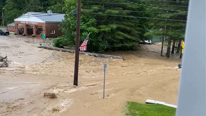
Image 16 of 40Floodwaters rushed through Ludlow, Vermont, on Monday. (henrysweatherchannel)
![]() Image 17 of 40
Image 17 of 40Floodwaters rushed through Ludlow, Vermont, on Monday. (henrysweatherchannel)
![]() Image 18 of 40
Image 18 of 40Floodwaters rushed through Ludlow, Vermont, on Monday. (henrysweatherchannel)
![]() Image 19 of 40
Image 19 of 40Floodwaters rushed through Ludlow, Vermont, on Monday. (henrysweatherchannel)
![Images of flooding damage at the U.S. Military Academy at West Point, New York caused by flash flooding on Sunday, July 9, 2023.]() Image 20 of 40
Image 20 of 40Images of flooding damage at the U.S. Military Academy at West Point, New York caused by flash flooding on Sunday, July 9, 2023. 9 (Image credit: U.S. Military Academy, West Point) ( )
![Images of flooding damage at the U.S. Military Academy at West Point, New York caused by flash flooding on Sunday, July 9, 2023.]() Image 21 of 40
Image 21 of 40Images of flooding damage at the U.S. Military Academy at West Point, New York caused by flash flooding on Sunday, July 9, 2023. 9 (Image credit: U.S. Military Academy, West Point) ( )
![Images of flooding damage at the U.S. Military Academy at West Point, New York caused by flash flooding on Sunday, July 9, 2023.]() Image 22 of 40
Image 22 of 40Images of flooding damage at the U.S. Military Academy at West Point, New York caused by flash flooding on Sunday, July 9, 2023. 9 (Image credit: U.S. Military Academy, West Point) ( )
![Images of flooding damage at the U.S. Military Academy at West Point, New York caused by flash flooding on Sunday, July 9, 2023.]() Image 23 of 40
Image 23 of 40Images of flooding damage at the U.S. Military Academy at West Point, New York caused by flash flooding on Sunday, July 9, 2023. 9 (Image credit: U.S. Military Academy, West Point) ( )
![Images of flooding damage at the U.S. Military Academy at West Point, New York caused by flash flooding on Sunday, July 9, 2023.]() Image 24 of 40
Image 24 of 40Images of flooding damage at the U.S. Military Academy at West Point, New York caused by flash flooding on Sunday, July 9, 2023. 9 (Image credit: U.S. Military Academy, West Point) ( )
![Images of flooding damage at the U.S. Military Academy at West Point, New York caused by flash flooding on Sunday, July 9, 2023.]() Image 25 of 40
Image 25 of 40Images of flooding damage at the U.S. Military Academy at West Point, New York caused by flash flooding on Sunday, July 9, 2023. 9 (Image credit: U.S. Military Academy, West Point) ( )
![A photo showing water rushing down Drew Road in Highland Falls, New York, on Sunday, July 9, 2023.]() Image 26 of 40
Image 26 of 40A photo showing water rushing down Drew Road in Highland Falls, New York, on Sunday, July 9, 2023. (New York State Division of Homeland Security & Emergency Services/Facebook)
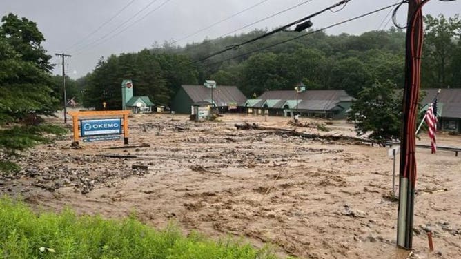
![A photo showing devastating flooding near the Okemo Ski Resort in Ludlow, Vermont, on Monday, July 10, 2023.]() Image 27 of 40
Image 27 of 40A photo showing devastating flooding near the Okemo Ski Resort in Ludlow, Vermont, on Monday, July 10, 2023. (@shanemcandrew/Twitter)
![A photo showing water covering a road in Ludlow, Vermont, on Monday, July 10, 2023. The state faces potentially catastrophic flash flooding on Monday.]() Image 28 of 40
Image 28 of 40A photo showing water covering a road in Ludlow, Vermont, on Monday, July 10, 2023. The state faces potentially catastrophic flash flooding on Monday. (Alisha Durgin)
![Raging floodwaters cover a road in Ludlow, Vermont, on Monday, July 10, 2023.]() Image 29 of 40
Image 29 of 40Raging floodwaters cover a road in Ludlow, Vermont, on Monday, July 10, 2023. (@AJShelto /Twitter)
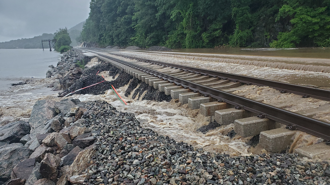
![Floodwaters cover railroad tracks in New York state on Sunday, July 9, 2023.]() Image 30 of 40
Image 30 of 40Floodwaters cover railroad tracks in New York state on Sunday, July 9, 2023. (MTA/Twitter)
![Mud and debris covers railroad tracks in New York state on Sunday, July 9, 2023.]() Image 31 of 40
Image 31 of 40Mud and debris covers railroad tracks in New York state on Sunday, July 9, 2023. (MTA/Twitter)
![A tree is seen across railroad tracks in New York state on Sunday, July 9, 2023.]() Image 32 of 40
Image 32 of 40A tree is seen across railroad tracks in New York state on Sunday, July 9, 2023. (MTA/Twitter)
![This image shows water covering railroad tracks in New York state on Sunday, July 9, 2023. Flooding was reported across the lower Hudson Valley after torrential rain.]() Image 33 of 40
Image 33 of 40This image shows water covering railroad tracks in New York state on Sunday, July 9, 2023. Flooding was reported across the lower Hudson Valley after torrential rain. (MTA/Twitter)
![Water rushes down a hill after torrential rain in New York on Sunday, July 9, 2023.]() Image 34 of 40
Image 34 of 40Water rushes down a hill after torrential rain in New York on Sunday, July 9, 2023. (MTA/Twitter)
![New York flooding]() Image 35 of 40
Image 35 of 40Rockland County- Palisades Interstate Parkway flooding. (New York State Police)
![Flooding around West Point in New York]() Image 36 of 40
Image 36 of 40Flash flooding around West Point in New York (West Point Garrison and Community)
![Richlandtown water rescue]() Image 37 of 40
Image 37 of 40Richlandtown, PA water rescue (Richlandtown Fire Co.)
![Richlandtown water rescue]() Image 38 of 40
Image 38 of 40Richlandtown, PA water rescue (Richlandtown Fire Co.)
![Flooding around West Point in New York]() Image 39 of 40
Image 39 of 40Flash flooding around West Point in New York (West Point Garrison and Community)
![New York flooding]() Image 40 of 40
Image 40 of 40Rockland County- Palisades Interstate Parkway flooding. (New York State Police)


At least one dead from the flooding
The Vermont Department of Health has confirmed the first death related to the recent storms and flooding.
Authorities said Stephen Davoll, 63, died as a result of a drowning in the town of Barre, outside of Montpellier.
Davoll is the only known fatality in the state as recovery efforts are still ongoing.
President Biden approves Vermont emergency declaration
Vermont Gov. Phil Scott held a news conference with other state and local leaders to provide updates on the ongoing situation and described it as "historic" and "catastrophic."
Scott announced during the news conferences that while overseas, President Joe Biden approved the state’s emergency declaration request, which would now help mobilize federal resources to support the response and recovery efforts for the ongoing disaster.
While the rain has now exited Vermont, more rain later this week could lead to more flooding as the state tries to continue with recovery efforts.
"Even though the sun may shine today and tomorrow, we expect more rain later this week, which will have nowhere to go in the oversaturated ground," Scott said. "So I want to be clear – we are not out of the woods. This is nowhere near over, and at this phase, our primary focus continues to be on life and safety before we can shift into a recovery phase."
WINDHAM, VERMONT - JULY 10: A road is severely damaged by flooding on July 10, 2023 in Windham, Vermont. Torrential rain and flooding has affected millions of people from Vermont south to North Carolina. (Photo by Scott Eisen/Getty Images)
(Getty Images)
Montpelier scrambles to move essential equipment
The city of Montpelier has moved its dispatch center to the water treatment plant, where joint operations were made with Barre City. The city will also move its full Emergency Operations Center to the treatment plant.
"Computer and radio systems at the police station may become incapacitated if floodwaters increase," Fraser said. "Again, this could be a dangerous situation."
Montpelier Police Chief Eric Nordenson also provided an update to Facebook and said the department had relocated dispatch and police and fire operations to the water treatment plant in Berlin because of flooding in the department's basement, city hall and fire department.
"Three radio towers positioned in Washington County used to dispatch fire and ambulances are currently not functional, and Washington Electric has been notified to attempt repairs," he said in the Facebook post. "Multiple water rescue teams are positioned in Montpelier, and we urge the public to please stay out of the downtown and off city roads. Our rescue crews, DPW staff, dispatchers and first responders are spread very thin and will need time to assess the damages."
Quechee, VT - July 10: A man stops to take a photo as heavy rain sends mud and debris down the Ottauquechee River. (Photo by Jessica Rinaldi/The Boston Globe via Getty Images)
(Getty Images)
Nordenson said the Wrightsville Dam water levels are being monitored on-site by the Vermont Dam Safety Management group.
"There is the possibility that the dam has some spillover, which can affect our current water levels downtown," he said.
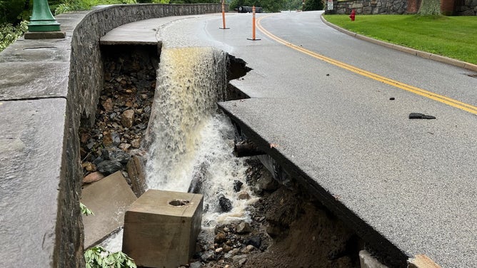
The water level in downtown Montpelier continued to rise Tuesday morning but slightly started to recede by Tuesday afternoon. However, the level reduction has been slower than anticipated, and the city had extended the downtown travel ban until at least 3 p.m. EDT Tuesday.
The Main Street Middle School gym has been opened as a temporary shelter until buses can pick up residents and take them to the Barre Auditorium, which is being staffed by the American Red Cross.
Vermont State Police said the state's swift water rescue teams performed more than 100 rescues across the state and are still busy performing rescues. Additional rescue teams from Connecticut, Massachusetts and North Carolina were also in Vermont to help, and others are on their way.
Helicopters from the National Guard are also being deployed to assist with evacuations in the hardest-hit communities and the most remote areas that are not accessible by swift water teams.
DRONE VIDEO SHOWS DISASTROUS FLOODING IN LUDLOW AFTER TORRENTIAL RAIN HITS VERMONT
Vermont rivers reach near-historic crests as floods turn deadly in New York
Watch: Haunting drone video shows Montpelier, Vermont, submerged in floodwaters
Dramatic drone video shows Montpelier, Vermont, submerged in floodwaters. Torrential rain across portions of the Northeast and New England sent rivers and streams above their banks leading to widespread flooding.
Torrential rain began on Sunday in New York’s lower Hudson Valley, forcing the National Weather Service to issue a Flash Flood Emergency for parts of Orange, Putnam, Rockland and Westchester counties due to ongoing catastrophic flooding.
At least one person was killed, and numerous water rescues were conducted after rain caused the rivers and streams to overflow their banks, leading to roadways being washed away.
The rain shifted into New England on Monday, with more flooding occurring in Connecticut, western Massachusetts and Vermont, which saw the most severe flooding.
At one point on Monday, nearly the entire state of Vermont was under a Flash Flood Warning, and a Flash Flood Emergency was in effect for some areas throughout Monday morning.
The catastrophic flooding is expected to continue Tuesday in Vermont after up to 9 inches of rain fell in parts of the state, sending rivers to crests higher than Hurricane Irene levels in August 2011 and topped only by the Vermont flood of 1927 – the greatest natural disaster in the state's history.
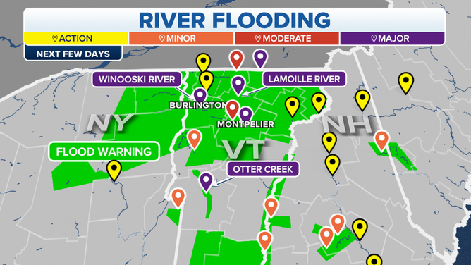
Forecast river flooding in Vermont over the next few days.
(FOX Weather)
The Winooski River at Montpelier reached 21.35 feet Tuesday morning, surpassing the 19.05-foot crest set during Irene in 2011 to become the second-highest crest on record. This water flooded the streets of downtown Montpelier.
The Winooski River at Essex Junction, just east of Burlington, crested at 22.56 feet Tuesday afternoon, which made it the third-highest crest at that location.
As of late Tuesday, the water level at both sites had started to quickly recede.
Many areas of Vermont picked up more than a half-foot of rain, which is why there have been so many reports of flooding.
Plymouth received more than 9 inches of rain between Sunday and Monday, with Mount Holly Heights receiving around 8.66 inches. Montpelier and Barre picked up more than 7 inches of rain.
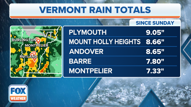
Top rain totals in Vermont between Sunday and Monday.