Vermont’s latest flooding disaster approaches levels not seen since the Great Flood of 1927
During the most recent flooding event, Montpelier reported a rainfall total of 6.82" and Burlington say 2.38". The greatest storm total was 9.2", just east of the Green Mountains.
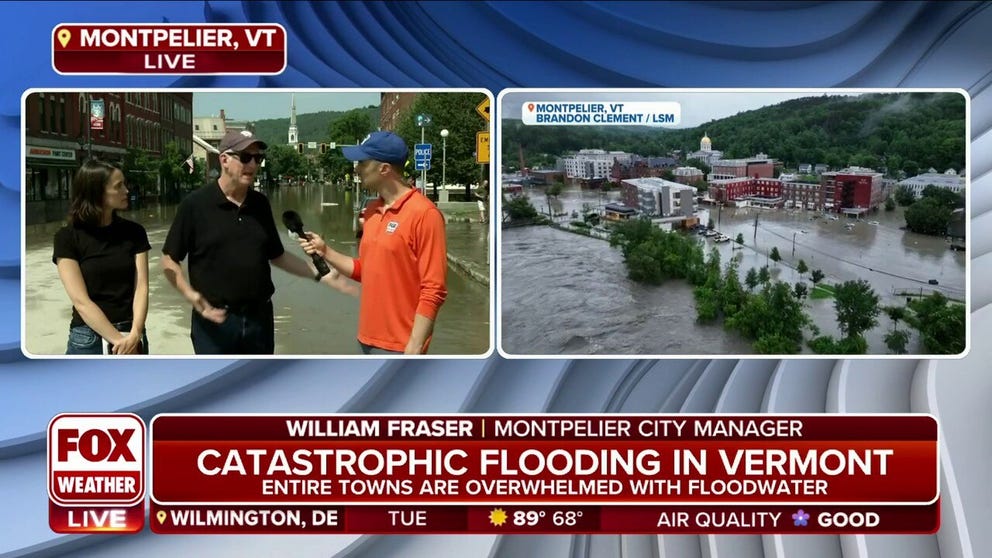
Montpelier City Manager: Flooding Is 'Definitely Worst Than Irene'
William Fraser and Kelly Murphy, City Manager and Assistant City Manager of Montpelier, VT, respectively, joined FOX Weather's Ian Oliver to discuss the flooding across their city.
Vermont is a state known for its natural beauty, but the rolling mountains and valleys can lead to disastrous consequences when too much rain falls in a short period.
During the recent slow-moving cold front, widespread rainfall totals reached 6-9" along the Green Mountains, meaning communities in the lower-lying valleys experienced feet of runoff.
Many rivers and streams reached their second-highest peaks on record, beating crests set during Hurricane Irene in 2011 but falling short of levels reported during the Great Vermont Flood of 1927.
"It is definitely worse than Irene for our city by 100-fold, but for other places in the state, maybe not so much. I think in terms of the lead-up, when we began getting predictions of catastrophic rain, the initial river height predictions were kind of in line with Irene. So we thought, ‘We’ll have some street flooding, we’ll have some inconvenience,’" said Bill Fraser, Montpelier’s city manager. "But, with Irene, we were able to kind of clean up and be open for business in two days. This went way beyond that. We’re going to be in cleanup mode and building inspection mode for quite a while."
Hundreds of water rescues took place throughout the state, with one fatality reported in the town of Barre.
Damage assessments are still underway to determine the scope of the disaster, but much like the disasters in 1927 and 2011, the federal government has promised resources to help get Vermonters back on their feet.
DRONE FOOTAGE SHOWS RAILROAD TRACKS SUSPENDED IN AIR AFTER VERMONT FLOODING WIPES OUT TRESTLE
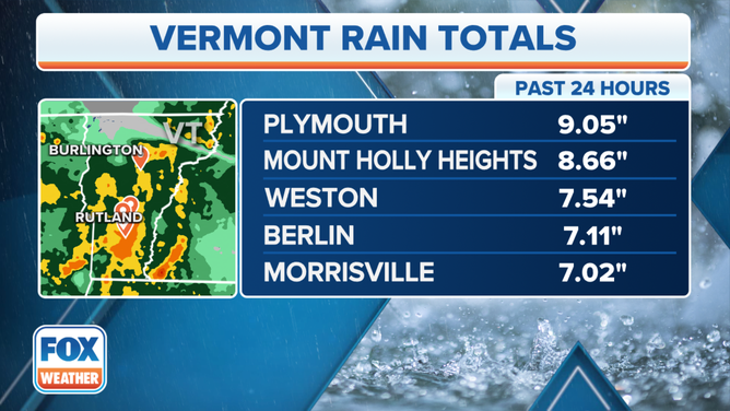
Top rain totals in Vermont over the past 24 hours.
(FOX Weather)
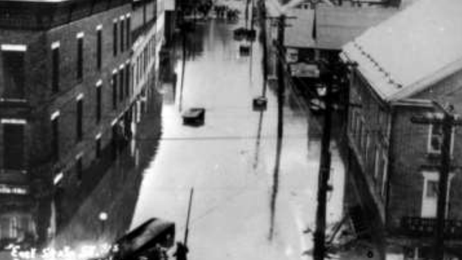
The Great Vermont Flood of 1927 still tops the charts
Considered to be the worst disaster in Vermont’s history, the Great Vermont Flood of 1927 caught many off-guard, leading to 84 deaths and hundreds injured.
Soils were already saturated by heavy rainfall during the fall of 1927 when a surge of tropical moisture led to an additional 8-10" falling during early November.
According to a NOAA historical summary, one of the hardest hit areas was the Winooski Valley, where most residents lived.
More than 1,200 bridges and culverts were washed out, and damage was estimated to be at least $35 million, which is around $600 million when adjusted to today’s inflation values.
The Winooski River at Montpelier reached a crest of 27.10 ft, more than 12 feet above flood stage.
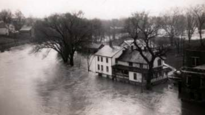
![The Great Flood of 1927]() Image 1 of 3
Image 1 of 3Middlebury, VT flooding. (NOAA/UVM Landscape Change Program)
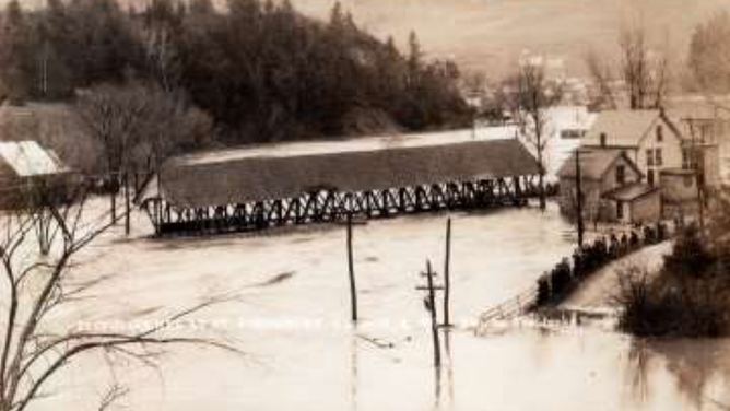
![The Great Flood of 1927]() Image 2 of 3
Image 2 of 3A covered bridge floating down river in St. Johnsbury, VT. (NOAA/UVM Landscape Change Program)
![The Great Flood of 1927]() Image 3 of 3
Image 3 of 3Montpelier, VT flooding (NOAA/UVM Landscape Change Program)
Even though similar rainfall totals occurred during the June 2023 storm system, there are subtle differences between the two historical events.
Unlike in 1927, the Green Mountain State as a whole was experiencing dry and drought conditions during the spring and summer before the recent rains started to fall.
The U.S. drought monitor reported nearly 61% of the state was experiencing unusually dry weather, and more than 8% met the criteria of officially being in a drought.
That means the ground and waterways were able to absorb a large amount of moisture before significant runoff began.
And where there was the potential for runoff, infrastructure had been improved following the state’s worst disaster in the 1920s
According to NOAA, the U.S. Army Corps of Engineers built several flood retention reservoirs and dams throughout the Winooski River basin which not only put the state in better shape for the most recent round of wet weather, infrastructure was in place for the arrival of the Hurricane Irene in 2011.
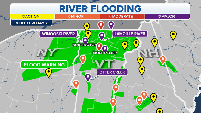
Forecast river flooding in Vermont over the next few days.
(FOX Weather)
DAYLIGHT DRONE VIDEO SHOWS CATASTROPHIC FLOODING SUBMERGING DOWNTOWN MONTPELIER, VERMONT
Hurricane Irene records smashed around the state’s capital
River levels around Vermont’s capital city quickly rose Tuesday past observations taken back during Hurricane Irene in 2011.
Irene peaked in intensity over the Bahamas as a Category 3 hurricane but was downgraded to a tropical storm when it reached the Northeast.
The downgrade did not stop the storm from producing widespread rainfall amounts of 6-9" and wind gusts up to 60 mph.
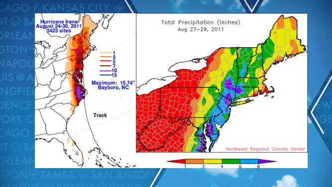
Hurricane Irene 2011 precipitation
"As a result of the storm, 500 miles of roadway and approximately 1,200 bridges and culverts were either damaged or destroyed, 6 of which were completely washed away, including the historic Bartonsville covered bridge. In addition, 3,500 homes were damaged or destroyed, 629 cultural sites damaged, and 20,000 acres of farmland flooded. Overall, Irene caused over $700 million in damages to state infrastructure and private property," the National Weather Service stated.
Similar to the recent event, infrastructure such as dams and reservoirs were in place to limit flooding to the extent they could, but when millions of tons of water fall within a short time period, there is little that can be done to tame the forces of Mother Nature.