New England blasted with snow, ice as significant winter storm swept across Northeast
New York City and the surrounding Northeast region saw a messy Thursday morning commute before conditions began to improve and the storm shifted toward New England.

A beautiful snow-filled scene in Connecticut today
The area will be under a winter storm watch on Saturday evening accompanied by snow.
NEW YORK – A winter storm moved through New England Thursday afternoon after delivering a messy combination of heavy snow, sleet and freezing rain in the Midwest and Northeast. This widespread mixed precipitation cleared out of New England Thursday evening, leaving mostly dry conditions until a second, even stronger storm is expected this weekend.
New York City and the surrounding Northeast region saw impacts to their Thursday morning commute before conditions began to improve.
"Definitely much more like what Punxsutawney Phil said. Six more weeks of winter," FOX Weather Meteorologist Michael Estime reported from Central Park in New York City. "And boy, we are in the thick of it right now."
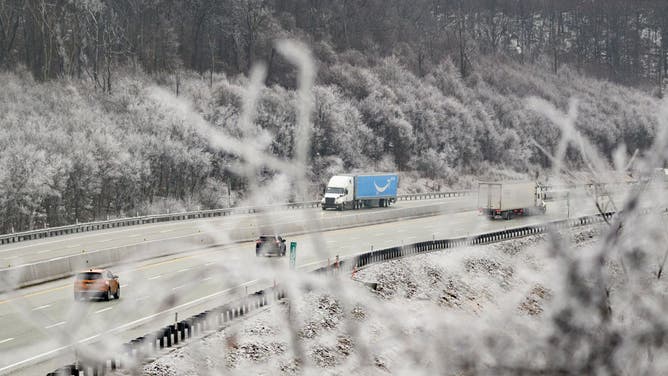
![OMERSET, PENNSYLVANIA - FEBRUARY 6: Traffic moves through the mountains surrounded by iced trees Thursday morning after freezing rain fell on the area Wednesday night before heading east on February 6, 2025 in Somerset County, Pennsylvania. Millions of people have been put on alert as the storm moves into New England.]() Image 1 of 8
Image 1 of 8SOMERSET, PENNSYLVANIA - FEBRUARY 6: Traffic moves through the mountains surrounded by iced trees Thursday morning after freezing rain fell on the area Wednesday night before heading east on February 6, 2025 in Somerset County, Pennsylvania. Millions of people have been put on alert as the storm moves into New England. (Jeff Swensen)
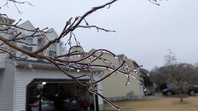
![An 1/8 inch of ice was reported in Bel Air, Maryland, on Thursday.]() Image 2 of 8
Image 2 of 8An 1/8 inch of ice was reported in Bel Air, Maryland, on Thursday. (Shane Brown)
![An 1/8 inch of ice was reported in Bel Air, Maryland, on Thursday.]() Image 3 of 8
Image 3 of 8An 1/8 inch of ice was reported in Bel Air, Maryland, on Thursday. (Shane Brown)
![People walk through light morning snow in Brooklyn on February 06, 2025 in New York City. New York City received about an inch of snow before the precipitation turned into all rain.]() Image 4 of 8
Image 4 of 8People walk through light morning snow in Brooklyn on February 06, 2025 in New York City. New York City received about an inch of snow before the precipitation turned into all rain. (Spencer Platt/Getty Images)
![]() Image 5 of 8
Image 5 of 8NEW YORK CITY - FEBRUARY 06: People walk through light morning snow in Brooklyn on February 06, 2025 in New York City. New York City received about an inch of snow before the precipitation turned into all rain. (Photo by Spencer Platt/Getty Images) (Spencer Platt/Getty Images)
![Cars drive through light morning snow in Brooklyn on February 06, 2025 in New York City. New York City received about an inch of snow before the precipitation turned into all rain.]() Image 6 of 8
Image 6 of 8Cars drive through light morning snow in Brooklyn on February 06, 2025 in New York City. New York City received about an inch of snow before the precipitation turned into all rain. (Spencer Platt/Getty Images)
![People walk through light morning snow in Brooklyn on February 06, 2025 in New York City. New York City received about an inch of snow before the precipitation turned into all rain.]() Image 7 of 8
Image 7 of 8People walk through light morning snow in Brooklyn on February 06, 2025 in New York City. New York City received about an inch of snow before the precipitation turned into all rain. (Spencer Platt/Getty Images)
![An 1/8 inch of ice was reported in Bel Air, Maryland, on Thursday.]() Image 8 of 8
Image 8 of 8An 1/8 inch of ice was reported in Bel Air, Maryland, on Thursday. (Shane Brown)


The storm's impact varied across the region. While New York City primarily saw sleet and some snow, parts of New Hampshire, Vermont and Maine reported getting between 3 and 5 inches of snow.

Southern New Hampshire dusted with snow from winter storm
A winter storm blasted the Northeast with snow and ice Thursday before moving out Thursday evening. Parts of New Hampshire reported 3-5 inches of snow.
In Boston, the Public Works Department sent out more than 400 pieces of equipment to treat the streets ahead of the worst of the snow.
On Interstate 90, speeds were reduced to 40 mph in both directions while the Massachusetts Department of Transportation highway districts treated roadways.
DON'T LEAVE ANY OF THESE ITEMS IN YOUR CAR THIS WINTER
The worst icing of the event occurred across portions of the Appalachians from western Pennsylvania through western Maryland, eastern West Virginia and northwestern Virginia.
Ice Storm Warnings were in effect for up to a quarter-inch to half-inch of ice accretion.
WHY DO BRIDGES AND OVERPASSES FREEZE BEFORE ROADS?
Much like in the Midwest, warm air flooded in, changing the snow to rain.
Many schools in the affected areas were closed Thursday or operated on a delayed schedule.
HOW TO DRIVE IN ICY CONDITIONS
Farther south, freezing rain and even thunderstorms created additional challenges in parts of the Ohio Valley and central Appalachians.
Due to the instability associated with the storm system, severe weather and flooding struck portions of Kentucky and West Virginia on Thursday morning.

Watch: Sirens wail during Tornado Warning in Kentucky
A video shared from Bonnieville, Kentucky, shows sirens sounding during a Tornado Warning on Thursday morning.
The freezing rain initially broke out Wednesday afternoon in the mid-Mississippi Valley before spreading toward the Great Lakes overnight.
DRIVING ON THE ICE AND DRIVING IN THE SNOW: WEATHER DRIVING TIPS FOR DRIVING IN INCLEMENT WEATHER
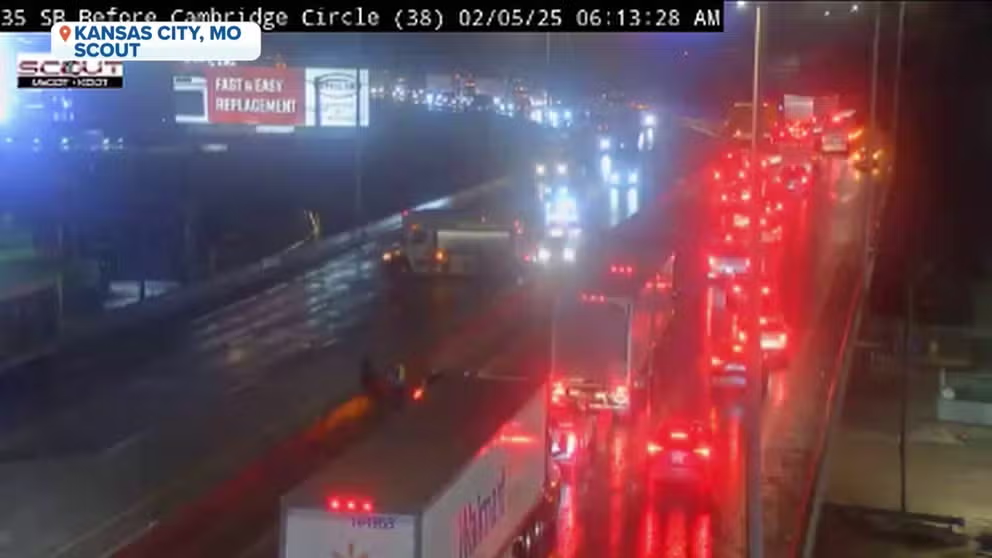
Watch: Crash closes ice-covered I-35 in Kansas City
Numerous crashes have been reported in the Kansas City, Missouri, area as a developing winter storm coats area roads in ice. Officials have urged people to delay travel until Thursday, if possible.
Temperatures rose above freezing by Thursday afternoon, ending the ice threat in cities like Chicago, Fort Wayne, Indiana, and Columbus and Cleveland in Ohio.
Looking ahead, the Northeast isn't expected to catch a break for long.
The FOX Forecast Center said a second, even stronger storm is expected this weekend. The storm is also expected to bring freezing rain to nearly the same areas that were impacted during this first storm. However, the FOX Forecast Center said there would be one major difference – this next storm will pack much more snow.
Heavy snow is looking increasingly likely on Saturday across the Upper Midwest and Great Lakes region. Cities like Minneapolis, Milwaukee and Detroit could see their biggest snowstorm so far this winter.