Chicago braces for possible blizzard this week after dodging recent snow
Other cities near the Great Lakes, such as Milwaukee and Detroit, are also expected to see heavy snow.

Chicago bracing for snow and strong winds after dodging early week storm
Chicago made it through the early week storm relatively unscathed while norther suburbs were clobbered with snow. FOX Weather's Robert Ray takes us to the Windy City to talk about preps for the next storm which includes screaming wind, blowing snow, coastal flooding and excessive cold.
CHICAGO – After dodging the snow from the latest storm, Chicago could finally see the snow pile up late this week as meteorologists hint at the possibility of blizzard conditions.
"When this storm came through (early week), it put down nearly a foot in Des Moines, Iowa," said FOX Weather Meteorologist Amy Freeze. "Now there's another winter storm brewing for the Central Plains and the Midwest. The big difference this time is that the cold air is coming."
Freeze said that Chicago could be placed under a Blizzard Warning for the first time in years.
WHAT MAKES A BLIZZARD DIFFERENT FROM AN ORDINARY SNOWSTORM?
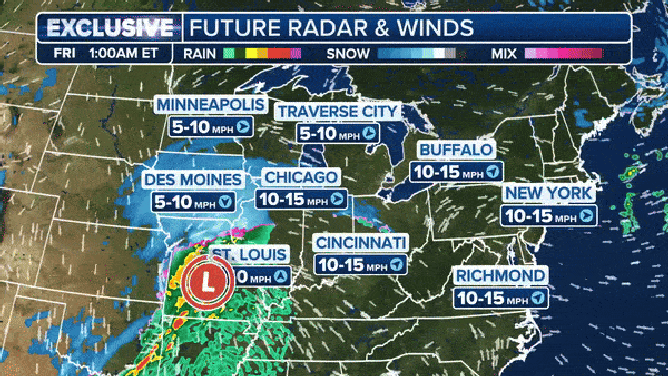
The combination of strong winds and heavy snowfall could mean blizzard conditions for the Midwest.
(FOX Weather)
Blizzard conditions mean that visibility is reduced to less than a quarter mile with wind gusts of at least 35 mph. Those conditions must continue for at least three hours to be considered an official blizzard. The FOX Model shows 20- to 30-mph sustained winds, and the NWS in Chicago wrote that gusts could be as strong as 45-50 mph.
The last time Chicago was under a Blizzard Warning was Nov. 2018. It was Feb. 2011, the last time other Great Lakes locations such as Milwaukee and Detroit were under a Blizzard Warning.
"By Friday, it will be a powerful storm, perhaps even stronger than the one we just saw, moving into the Great Lakes" echoed meteorologists at the FOX Forecast Center. "Meanwhile, an increasingly tight pressure gradient … will lead to very strong winds that will create very dangerous/near blizzard conditions with this system."
Weather models show impressive lake-effect bands setting up to add even more snow.
NEXT CROSS-COUNTRY WINTER STORM TO PRODUCE RENEWED ROUNDS FO HEAVY SNOW, SEVERE WEATHER

Chicagoland bracing for 5-12 inches snow
The third major storm in a row is charging across the U.S. While Chicago missed out on the inches to foot of snow with the previous storm - they will get dumped on by #3.
How much snow?
While areas of the Midwest and Plains saw over a foot of snow from the previous storm, Downtown Chicago's streets stayed largely clear with a mixture of rain, sleet and wet snowflakes. O'Hare International Airport, 15-20 miles outside of downtown, recorded 2.8 inches of snow. Farther out, Geneva saw almost 7 inches of snow, about 40 miles west of the city.
When the snow arrives late Thursday into early Friday, temperatures will hover around freezing, meaning a rain/snow mix, possibly freezing rain to the south, turning to all rain in the morning.
"Then as the main surface low approaches and the best dynamics arrive, allowing precip intensity to increase and change precip to all snow in the afternoon," forecasters at the NWS in Chicago wrote in their forecast discussion. "The snow may also be wetter, limiting snow/water ratios and amounts further. Eventually, the snow will become drier as colder air spreads into the area Friday evening."
HOW MUCH SNOW WILL AN INCH OF RAIN PRODUCE?
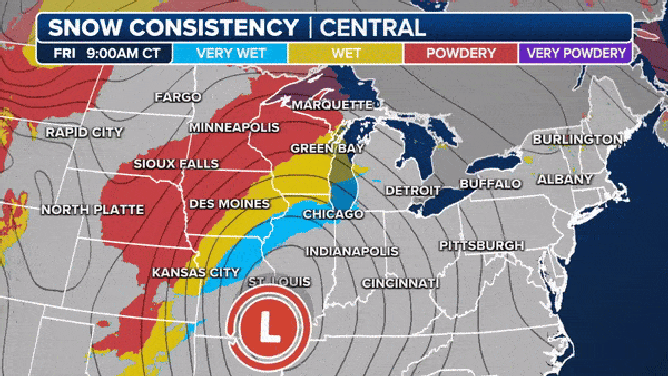
Very wet snow Friday morning changes to powdery by the evening.
As the cold air filters in so do the strong winds. Blizzard conditions are possible through Saturday morning.
"And the heavy snow is really surrounding the Great Lakes, and you're talking about really big snowfall totals that are just a couple of days away," said FOX News Meteorologist Adam Klotz. "We are talking about the Chicago area 5-8 inches easy, but you're going to see places getting up to a foot. That will not be a surprise."
HERE'S WHY 'BLIZZARD ALLEY' IS IN THE NORTHERN PLAINS

(FOX Weather)
The bullseye for the heavy snow is north of Chicago and areas that are prone to lake effect snow. Milwaukee and Green Bay could see up to a foot and a half of snow. The western half of Detroit could see the same.
All that snow, including the inches to a foot that just fell, will be blowing around in tropical storm-force wind gusts.

(FOX Weather)
The snow will stick around for a while as an Arctic blast takes residence over the center of the country. Chicago is forecast to drop below zero early Sunday morning.
"This one is likely going to be a doozy this weekend. So you have all that snow and then all of a sudden on Sunday those temperatures will begin to drop.," said FOX Weather Correspondent Robert Ray. "And next week, Chicago will not get out of the teens as highs, and it will hover for lows or highs at some point around zero Monday and Tuesday. And you can imagine with the wind chills, we could see -20 to -30 the way it feels."
The NWS classifies that level as "dangerously low wind chills."
HERE'S HOW LONG IT'LL TAKE YOU TO GET FROSTBITE AS WIND CHILLS DIP BELOW ZERO
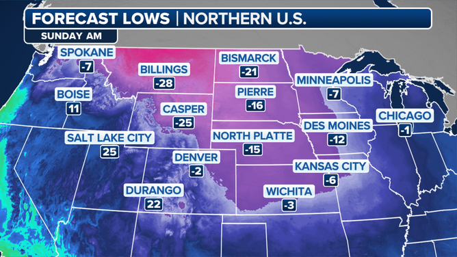
Sunday lows.
(FOX Weather)
Chicago hasn't seen much snow in recent years
Despite the frigid, blustery forecast, Ray says the people of Chicago that he has talked to are looking forward to the snow.
"Chicago has not seen a bunch of snow in a couple of years, and I can tell you, Chicagoans would much rather see snow falling and big wins than this sort of wimpy sleet and rain that we saw yesterday," Ray said.
Chicago's average yearly snowfall is 38.4 inches. Last season, the city only saw 20.2 inches. In the 2021 to 2022 season, the city only saw 32.8 inches. The late snow that season nearly set a record for the longest stretch without measurable snow. The snowless streak ran from March to December in 2021 – 287 days. That was just three days shy of the 2021 record.
Minneapolis, Milwaukee, Chicago and Detroit have all only received 25%-90% of the snow usually seen by this time of year.
WHAT YOU SHOULD KNOW ABOUT BLOWING, DRIFTING SNOW

(FOX Weather)