Cross-country winter storm to produce blizzard conditions around Chicago, severe weather across South
An active El Nino weather pattern will help energize another major storm system. The FOX Forecast Center expects a significant band of snow will stretch from Missouri to Michigan, with cities such as Chicago and Detroit receiving their most significant accumulations of the season.

Major storm system to produce blizzard conditions around Great Lakes
Forecast models show snowfall amounts could top more than a foot around the Great Lakes with winds of more than 40 mph.
A storm system over the Rockies and the Southwest promises to deliver blizzard conditions and severe weather across the eastern half of the nation over the next few days.
The FOX Forecast Center expects a band of heavy snow will fall from Missouri to Michigan, with severe thunderstorms possible from Texas through the Carolinas and the mid-Atlantic.
Similar to the past two storm systems, major cities in the Northeast will miss out on seeing accumulating snow, with temperatures simply too warm to support frozen precipitation along the coast, but it'll be a much different story along the Great Lakes.
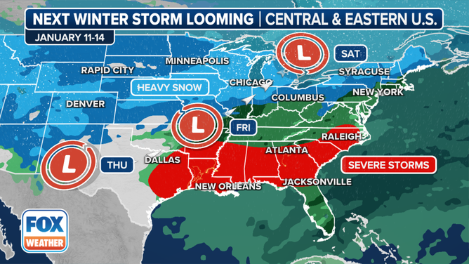
The next cross-country storm will sweep across the U.S. later this week and into the weekend.
(FOX Weather)
The storm system has already produced blizzard conditions on some mountains in the Pacific Northwest and triggered a deadly avalanche in California.
Major impacts are expected to begin late on Thursday across the Plains and last until the storm system pushes into Canada and off the Eastern Seaboard on Saturday.
Winter weather impacts

(FOX Weather)
The snowfall is expected to be the lightest over the Plains and increase in coverage and intensity throughout the Great Lakes.
The first flakes are expected to start flying on Thursday, with Chicago, Detroit, Milwaukee and Indianapolis all seeing accumulating snow by Friday.
Forecast models show some communities in the Great Lakes could pick up snowfall accumulations in the double digits with wind gusts of more than 40 mph.
The Chicago region was placed under a Winter Storm Watch on Thursday and local National Weather Service meteorologists warned that blizzard conditions were likely in northeast Illinois and northwest Indiana on Friday evening through Saturday morning.
Computer model runs show the heaviest snowfall will occur from northern Illinois through Wisconsin and Michigan, where more than a foot of new powder was possible.
Millions of residents from the Plains through the Great Lakes are under winter weather alerts.

(FOX Weather)
The combination of the heavy snow and gusty winds could make travel impossible along the I-80 corridor, with frozen precipitation making it as far south as Interstate 40.
Cities such as Chicago and Detroit sit ready to at least double their snowfall accumulations for the season. The Windy City has only reported around 6" of snowfall since Dec. 1, and Detroit has only seen a measly 1.1" of snow.
Where warm air will be dominant, south of Interstate 40, communities have the chance of seeing strong to severe storms.
EL NINO APPEARS TO BE ON VERGE OF RAPID COLLAPSE
Severe weather impacts

Another cross-country storm to bring severe weather to storm-weary South
Another powerful storm system is expected to bring more severe thunderstorms, including possible tornadoes, to the South at the end of the week. The region is continuing to pick up the pieces after deadly storms tore across the region on Monday and Tuesday.
NOAA’s Storm Prediction Center (SPC) has highlighted areas in the South days in advance of the actual storm system arriving, meaning that certainty is high for threats of damaging winds and tornadoes on Thursday and Friday.
Thursday’s highest threat zone is centered over East Texas, Arkansas, Louisiana and Mississippi. The SPC has placed this region at a level 2 out of 5 on its thunderstorm risk scale.
On Friday, the threat zone is expected to progress eastward and stretch from Mississippi through North Carolina.

(FOX Weather)
Forecasters warn that due to the available instability, the atmosphere could be conducive for more supercell thunderstorm development than what was experienced earlier in the week, which featured more of a linear storm structure.
Discrete cells are known to produce stronger tornadoes than those associated with squall lines, which leads to more widespread wind damage.

(FOX Weather)
"Discrete thunderstorms are always a huge concern because they can make powerful tornadoes," Merwin said. "It's like showing up to the buffet and you’ve got one person. These discrete thunderstorms can eat up all the energy in the atmosphere."
Communities such as Dothan, Alabama; Panama City, Florida; and Claremont, North Carolina, which were hit hard during a severe weather outbreak on Tuesday, are included in Friday's threat zone.

(FOX Weather)
However, the SPC placed areas of southeastern Alabama, central Georgia, including Atlanta, and the Carolinas in a level 3 out of 5 on its thunderstorm risk scale.
"But the subtropical jet, because of the El Niño phase, is allowing this to rip and roar and stay active down South," said FOX Weather Meteorologist Steve Bender.
DEADLY STORMS SWEEP ACROSS SOUTH WITH EXTENSIVE TORNADO DAMAGE
Arctic air follows

(FOX Weather)
Behind the frontal boundary will be the coldest air of the season, dropping temperatures to around 0 degrees as far south as Missouri and values reaching at least -30 degrees along the U.S.-Canada border.
As the next workweek progresses, the arctic air mass is expected to spread south and eastward, but questions remain on the staying pattern of the cold air.
POLAR VORTEX SET TO SEND ARCTIC BLAST DEEP INTO US STARTING LATER THIS WEEK
Will the cold air be able to stick around for an extended period, or will the air mass moderate, providing just a glancing blow of winter?
These details will matter because if the cold air mass has staying power, chances increase that a future storm system will be able to take advantage and produce snowfall in locales that are running historic deficits.