El Nino appears to be on verge of rapid collapse
When sea surface temperature anomalies reach 0.5 degrees Celsius (0.9 degrees Fahrenheit) or warmer than what is typical, an El Niño is considered to be underway. An El Niño is one of three phases of the El Niño-Southern Oscillation or what is commonly referred to as the ENSO. The current El Nino event started in June 2023.
The meaning of El Nino and La Nina
The status of whether the world is being impacted by an El Nino or a La Nina is determined by water temperatures in the central and eastern Pacific. (NOAA)
The climate pattern known as El Niño, which quickly strengthened into a strong event, appears to be on the brink of a major decline, which would send the world into what is known as a neutral status.
When sea surface temperature anomalies in parts of the Pacific reached a mean temperature of 0.5 degrees Celsius (0.9 degrees Fahrenheit) in June 2023, the first El Niño in nearly four years was considered to be underway.
According to data compiled by NOAA, the event became strong, with average anomalies reaching nearly 2 degrees C (3.6 degrees F) during the fall, with the latest reading now on the cusp at 1.9 degrees C (3.42 degrees F).
A status of at least 2 degrees C (3.6 degrees F) would have pushed the event’s standing into a Super-Niño status, the first since 2015-16. Based on cooling trends, odds are trending down of reaching that level, though NOAA forecasters still give a 54% chance of reaching Super-Niño levels.
El Nino computer model outlook.
(The Columbia Climate School, Columbia University / FOX Weather)
Many climate models and sub-surface data show an El Niño that could be on its last legs, with the average dipping below the 0.5 degrees C (0.9 degrees F) threshold during the spring, baring another round of warm water propagation.
NOAA’s latest forecast now suggests El Niño may be over as soon as April — a month earlier than last month’s forecast. The probability of El Niño conditions remaining in April has dropped from 62% to 37%.
Some of the most vigorous climate models show certain regions dipping below the El Niño threshold as early as January. Still, like any weather event, forecasts that greatly deviate from the consensus are not considered to be outliers and not reliable.
WHAT ARE EL NINO AND LA NINA CLIMATE PATTERNS?
Pressure gauges indicate El Niño is weak
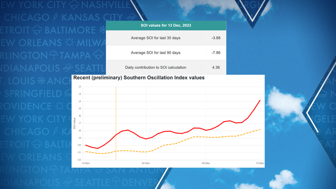
A tool that some forecasters use to determine the status of El Niño and La Niña events is the Southern Oscillation Index, or what is commonly referred to as the SOI.
The index measures pressure differences in the southwest Pacific, and when the gauge turns substantially positive, a La Niña event is likely happening or on the way. The reverse is also true, and when figures are markedly negative, an El Niño event is likely in progress.
Recent values provided by Australia’s Queensland Government show a streak of positive figures that have impacted the SOI count. In fact, at times, during the last 30 and 90 days, the figure has weakened below what is typically considered an El Niño event.
Latest Southern Oscillation Index values.
(Queensland Government / FOX Weather)
El Niños are known to exist when figures are at -8 on the index scale, and La Niñas exist when the average figure is around a positive 8.
The latest SOI values were -7.86 for the last 90 days and -3.88 for the last 30 days, which at a glance would argue against there being an El Niño around, but values change daily and could easily reach El Niño status again.
LITTLE-KNOWN WEATHER PATTERN WHEN EL NINO AND LA NINA ARE NO LONGER IN CONTROL
Sub-surface data indicates growing pool of cold water
Despite pressures in Darwin and Tahiti indicating that El Niño could be on its last leg, NOAA data depictions from satellites show no evidence of an emerging neutral or La Niña signal.
A large amount of real estate from South America to the south of Hawaii has anomalies that are 1-2 degrees C (1.8-3.6 degrees F) above average.
Without other observations, the depiction to an untrained eye would say El Niño is robust, but what is happening below the surface has forecasters abuzz.
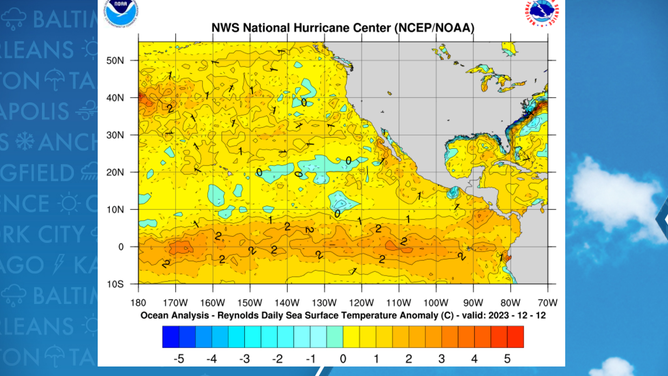
Water temperature anomalies in Pacific.
An animation of water anomaly trends below the surface shows the warm water does not run deep, especially as you head further west from South America.
A large extent of cold water around the international date line has formed and is slowly creeping upwards towards the surface and sliding eastward.
According to long-term climate models, this cool pocket should expand and intensify, especially in the eastern Pacific, where cold water is virtually nonexistent right now.
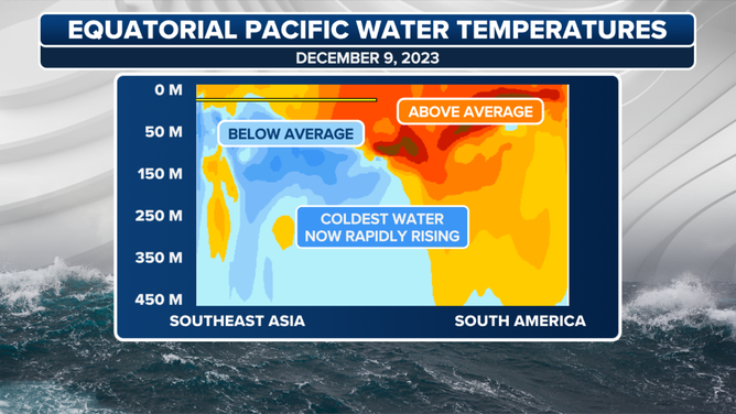
Equatorial Pacific Water Temperature Anomalies
(FOX Weather)
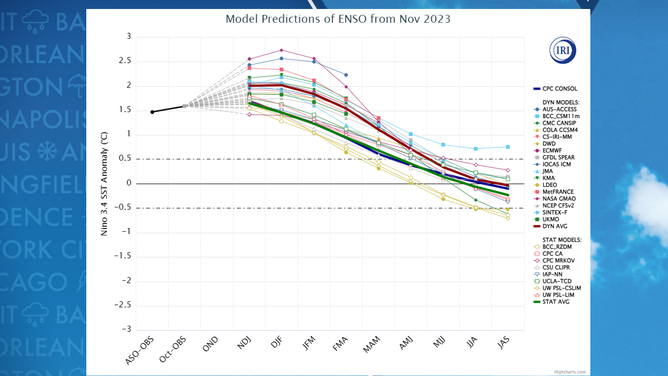
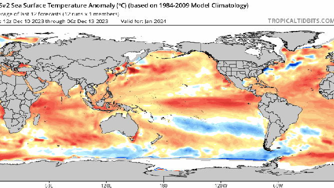
Forecast models show stunning flip
Climate models such as the Climate Forecast System Version 2 (CFSv2) from NOAA show a stunning flip in the pattern from an El Niño to neutral and even a La Niña within months.
As one ventures out in time, the reliability and accuracy of models tend to diminish, but there is no getting around the fact it is now a question of when, not if, the world will exit the El Niño pattern in 2024.
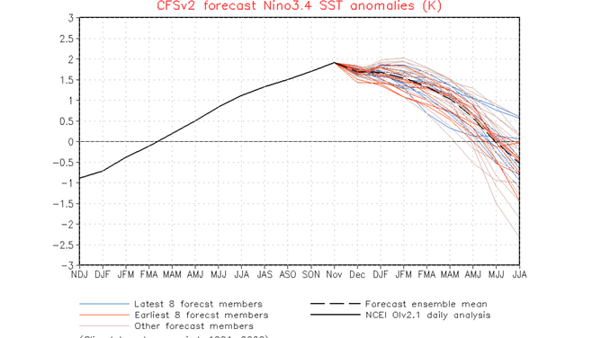
CFSv2 El Nino forecast for central region of the Pacific
"Model systematic errors arise because state-of-the-art climate models are still imperfect representations of reality. The complexity of the processes involved (is an additional challenge for models as small errors in one aspect can quickly amplify," climate scientist Eric Guilyardi previously stated in an ENSO blog.
So, if the majority of the members are correct and the world is to enter a neutral pattern, the question then becomes how long will the neutral phase will last.
Neutral phases have been known to last just a few months to several years.
Computer model animation for the coming months from tropicaltidbits.com.
(Tropicaltidbits.com / FOX Weather)
EL NINO, CLIMATE CHANGE TO LIKELY MAKE NEXT 5 YEARS HOTTEST RECORDED ON EARTH, WMO SAYS
Impacts on weather patterns
The future, the apparent downfall of El Niño, would complicate climate outlooks even further, as the length of the lag between when the weather changes and its associated neutral pattern is a not well-understood concept.
A fast-corresponding change would lead to fewer kinks in the jet stream, meaning more regional patterns dominate local weather.
A lag in the associated weather would keep El Niño-looking patterns around despite the world not officially being in an El Niño.
A lag is rather common as one pattern transitions into another. The world typically experiences a lag during large-scale events.
Take the summer solstice, for example; even though it occurs every June in the Northern Hemisphere, oceans and land usually don’t peak in temperature until July and August.
So, when the world would start feeling the impact of a neutral status would be anyone’s guess.
A neutral pattern typically means a busier spring severe weather season and hurricane season than typically experienced during an El Niño, but it all comes down to timing.
A pattern that flips during the late spring or summer would miss the heart of the severe weather season but catch the hurricane season in order to show its effects. A pattern change in September or beyond would miss out on impacting the 2024 hurricane season but would be in place for next winter.
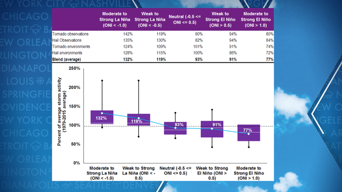
![Hail and tornado study]() Image 1 of 2
Image 1 of 2Hail and tornado activity versus state of atmosphere. (Willis Re/Columbia University)
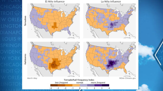
![La Nina tornado map]() Image 2 of 2
Image 2 of 2Where typical tornado activity occurs during El Nino and La Nina years. ( )