What is a super El Nino?
Warming sea surface temperatures in the central-east equatorial Pacific lead to the formation of an El Niño climate pattern. A super El Niño is declared when water temperatures in the central and eastern Pacific Ocean reach at least 2 °C or warmer.
What will a strong El Nino mean for your weather?
FOX Weather brings in Colorado State research scientist Marybeth Arcodia to explain what a historically strong El Nino means and takes a look back at previous historically strong years.
When sea surface temperature anomalies in critical parts of the Pacific Ocean have warmed to at least 2 °C or more above normal, a super El Niño event is considered to be underway.
Super El Niños are considered to be rare, as the world has only recorded three of these events since the 1950s.
Despite their common appearance, El Niño events are not similar, and NOAA says the weather patterns can lead to varying impacts.
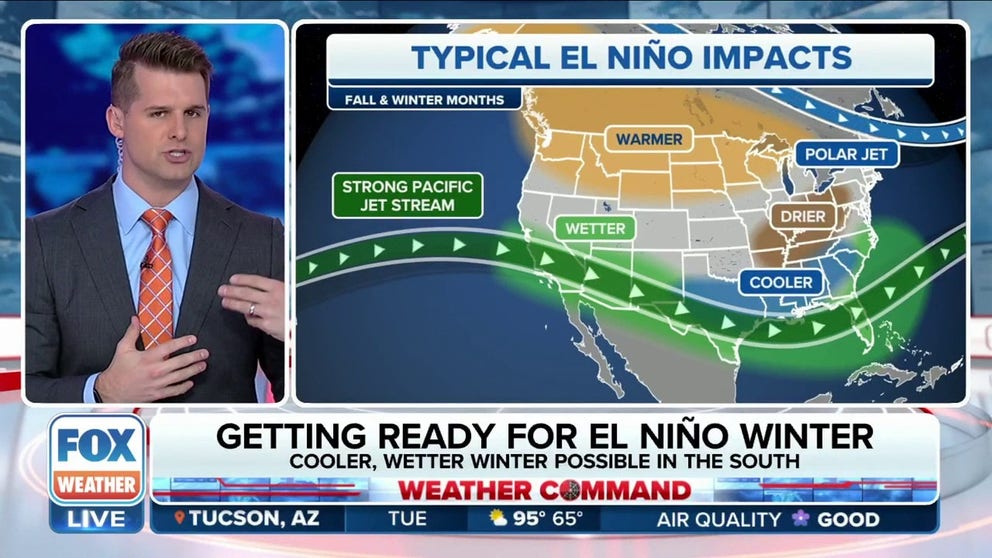
Classic El Niño events are known to produce stormy weather across the southern tier of the U.S., while the northern part of the country sees less rollercoaster-like conditions.
Major events in 1982-83 and 1997-98 produced more than 150 percent of average precipitation in the Golden State. However, the record-breaking El Niño of 2015-16 led to less rainfall than typically experienced during a non-event.
HERE’S WHAT AN EL NINO CLIMATE PATTERN IS
Typical El Nino impacts become more likely with a strong or historic event.
(FOX Weather)
NOAA declared the most recent El Niño event to be underway in June – the first to be witnessed around the globe since 2019.
As is typical, when the event kicked off, water temperature anomalies in the eastern and central Pacific were considered to be only .5-1 °C above normal, but that anomaly has grown to between 1- 2 °C, making the event moderate in nature.
Average ocean temperature readings above 2 °C would make the event strong, but determining the peak of the anomaly is a challenging concept.
WORLD’S OCEANS SET RECORD WARMTH PAVING WAY FOR ROBUST EL NINO
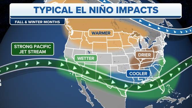
Climate models
(FOX Weather)
Mixed signals on how strong El Nino impacts will be
Dozens of computer models are run with different variations to determine the status and predict future cycles of the El Niño-Southern Oscillation (ENSO), but these computer outputs are rather inconclusive in saying the 2023-24 El Niño event will ever reach the significant threshold.
Another sign the El Niño pattern is not following a typical playbook and may be more challenging to forecasters is the amount of tropical activity observed around the globe.
During previous events, at least one ocean has seen a decrease in activity, but that has not been the case in 2023 with above-normal tropical cyclone formations in the Atlantic, Pacific and Indian oceans.
Forecasters say episodes of El Niño and La Niña typically last between nine and 12 months, but double or even triple dips can prolong the status for years.
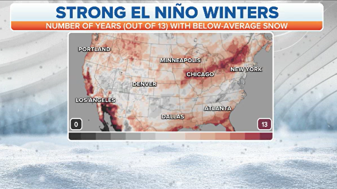
Strong El Nino winter impacts
(FOX Weather)