World's oceans set record warmth paving way for robust El Nino
Experts warn the transition into El Niño could lead to record heat around the globe. Since reliable technology started keeping track of world temperatures in the 1950s, the warmest year of any decade were periods dominated by an El Niño event, and the coldest were from La Niñas.
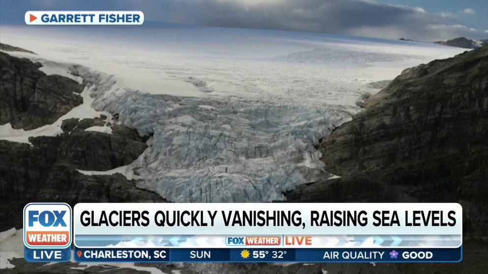
Glaciers are melting faster than scientists' forecast
Glaciers across the world are melting at a faster rate than scientists had expected. One photographer is taking to the sky to make sure future generations can still enjoy them.
A survey of the world’s oceans shows that large patches of the important waterways have temperatures that are well above average, causing historic warmth when compared to recent decades.
According to data from the University of Maine’s Climate Change Institute, the average daily sea surface temperature has hovered around 70 degrees Fahrenheit, which is nearly 2 degrees warmer than the running multi-decade mean.
A contributor to much of the warmth is the Pacific Ocean, which is the world’s largest basin and results in climate pattern changes around the globe.
Satellite analysis shows that areas off the South American coastline could have temperatures that are 5–10 degrees above average and are playing an important role in the emergence of the first El Niño climate pattern since 2019.
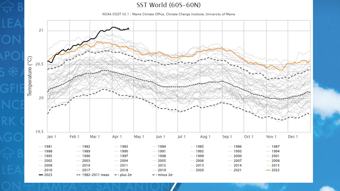
World ocean temperature status
(FOX Weather)
WHAT ARE EL NINO AND LA NINA CLIMATE PATTERNS?
El Niño events are known to pump a large amount of heat into Earth’s atmosphere, and since reliable technology started keeping track of world temperatures in the 1950s, the warmest year of any decade were periods dominated by an El Niño.
The super El Niño of 2015-16 is thought by climatologists to have pushed global temperatures to their highest levels in history.
NASA reports the warming of the atmosphere has repercussions, such as the spreading of diseases, altering drought and flood zones and leading to an increased threat of glacier melting.
Research conducted by CSIRO, Australia’s national science agency, found that during El Niño patterns, Antarctic ice shelves and ice sheets melt faster than average.
ANTARCTICA’S ‘DOOMSDAY GLACIER’ IS MELTING AWAY DIFFERENTLY THAN SCIENTISTS FIRST THOUGHT
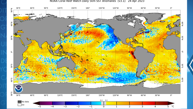
Ocean water temperature anomalies
(NOAA)
Reliable computer model guidance shows the upcoming El Niño lasting through the remainder of 2023 and well into 2024.
Under the expected patterns, NOAA’s National Centers for Environmental Information already believes there is a 99% chance the current year will rank among the 10-warmest on record and a 65% chance it will rank among the top five.