Hurricane Lee’s forecast cone includes US cities as East Coast stays on high alert from major storm
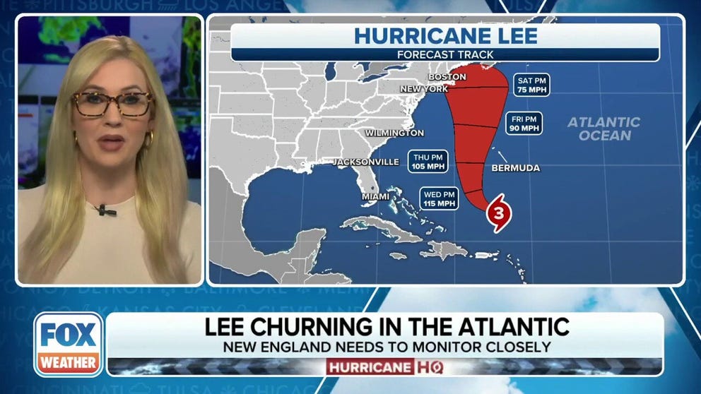
The latest analysis shows Lee has sustained wind speeds of around 115 mph, making the storm a Category 3, as it slowly churns in the southwestern Atlantic ocean.
Hurricane Lee remains Category 3 hurricane Monday night
Hurricane Lee has maintained Category 3 strength at 115 mph and forecasts are becoming more confident in its track to the north off the Eastern Seaboard.
Hurricane Lee's forecast track is coming into better focus. Updated forecasts and Hurricane Lee coverage can now be found at this link.
With some cities in the Northeast now in the forecast cone, Hurricane Lee remains a large, major hurricane as it moves across the Atlantic Ocean.
Dangerous surf and rip currents along a majority of the U.S. East Coast have started and will worsen as the week continues.
As of the latest advisory from the National Hurricane Center (NHC), Hurricane Lee had maximum sustained winds of 115 mph with some higher gusts, making it a Category 3 on the Saffir-Simpson Hurricane Wind Scale.
And for the first time in Lee's history, land was included in the forecast cone Monday. Nantucket, Massachusetts, remained in the extreme northwestern edge of the forecast cone while Boston had briefly been inside the edge of the cone on the NHC's Monday evening's forecast, only to be back just outside the cone on the Monday night update.

(FOX Weather)
The entire Maine coastline also now resides in the forecast cone as of the Monday night NHC forecast update, though the storm is currently forecast to be just under hurricane strength by the time it would arrive sometime late Saturday.
Will Lee have any impacts on the US East Coast?
While Lee is expected to move slowly as the steering currents wane, dangerous surf and rip currents are beginning along much of the U.S. Eastern Seaboard and will continue through the week.
Beachgoers on Cape Hatteras, North Carolina, have been warned about the dangerous conditions likely to occur this week.
According to the Cape Hatteras National Seashore Facebook page, visitors are being urged to avoid swimming in the ocean until conditions improve.
"Large breaking waves, life-threatening rip currents, beach erosion, ocean overwash and coastal flooding are all possible," the CHNS said in a Facebook post. " These dangerous conditions are expected to persist into this weekend."
FOX Weather Hurricane Specialist Bryan Norcross said Lee will likely track between the U.S. East Coast and Bermuda, though the exact path to the north is still unclear.
WHAT IS THE 'CONE OF UNCERTAINTY' IN HURRICANE FORECASTS?
Computer models predict Lee will stay offshore of the Eastern Seaboard, and some indicate that the Mid-Atlantic and Northeast coasts may still feel effects from the storm.
"The jet stream dip is forecast to pass Lee by on Friday, making room for a weak bubble of high pressure north of the hurricane to affect the storm’s path before another dip comes along," Norcross said. "The weak high could deflect Lee toward the New England coast. All this could result in Lee's track having an S-like shape. Although the curves would be slight, as things look right now, any zigging to the left would bring stronger winds near or over the coastline in parts of the Northeast, New England, and Atlantic Canada."
The NHC wrote in their late Friday night discussion that Lee will face some challenges later in the week-- the extensive wind field is mixing up some cooler waters from the depths below, and that area of the Atlantic is a touch cooler from similar earlier churning processes by recent passes of Hurricane Franklin and Tropical Storm Idalia. And the storm may begin to see some additional wind shear on its trek north due to an approaching trough.
But while the NHC's latest forecast does now have Lee's peak wind speeds gradually wane as it heads north later this week, the storm is expected to grow in size "and hazards will extend well away from the storm center by the end of the forecast period," and those in the Northeast should continue to monitor the storm.
Where is Hurricane Lee?
Hurricane Lee is about 410 miles to the north of the northern Leeward Islands and about 580 miles to the south of Bermuda, as of the 11 p.m. ET Monday NHC advisory.
The hurricane continues to head in a northwest direction and has begun slowing down over the southwestern Atlantic. The NHC said Lee will now hold roughly steady in strength through the next couple days.
THESE ARE THE STRONGEST HURRICANES IN HISTORY

(FOX Weather)
What is the forecast track for Hurricane Lee?
The NHC says Lee is moving to the northwest near 7 mph, and a slow west-northwest to northwest motion is expected over the next few days, followed by a turn to the north by the middle of the week.
On the current track, Lee is expected to pass near, but to the west, of Bermuda in a few days. The storm is then then expected to pass just off the New England coast and approach Nova Scotia around the end of the week.
TOP 5 STRONGEST HURRICANES EVER RECORDED IN ATLANTIC BASIN
There are currently no watches or warnings in effect for any landmasses, but the NHC says interests in Bermuda need to monitor the progress of Hurricane Lee.

(FOX Weather)
Hurricane Lee went from Category 1 to Category 5 in 24 hours
The storm underwent rapid intensification with extreme speed on Thursday, transforming from a Category 1 hurricane at 80 mph Wednesday night to a Category 5 monster at 165 mph just 24 hours later.
Lee was only the 13th Category 5 storm to form east of the Caribbean on record.
THESE HURRICANES HAVE ALL UNDERGONE RAPID INTENSIFICATION BEFORE US LANDFALL
The storm ran into wind shear Friday, sapping some of the storm's strength and knocking it down to a Category 3. Lee dropped to a Category 2 storm on Saturday but reenergized into a major hurricane Sunday afternoon. Lee is expected to continue to strengthen as it slowly swirls in the Southwestern Atlantic.
HURRICANE LEE LIVE TRACKER: SATELLITES SPAGHETTI COMPUTER MODELS, CONE OF CONCERN AND MORE