Tropical Storm Warnings expanded across New England as Hurricane Lee makes final approach
Boston could see sustained tropical-storm-force-winds by Friday evening through the first part of the weekend, and concerns are growing that with leaves still on trees the expected wind and possible heavy rain could snap branches and limbs and pull down power lines, leaving thousands of people in the dark.
Hurricane Lee's direct impacts start Friday in New England
Wet weather and winds associated with Hurricane Lee are expected to start impacting the coast on Friday with the worst of the weather on Saturday.
As of Friday morning, Hurricane Lee is hours away for blasting the New England coast with powerful winds and coastal flooding. Continuous coverage of Hurricane Lee has moved here.
A Tropical Storm Warnings are in place across New England as weather conditions are expected to start to deteriorate late Friday as Hurricane Lee makes its closest approach.
Boston could see sustained tropical-storm-force-winds by overnight, and locals are concerned that the wind and heavy rain could snap branches and limbs and pull down power lines, leaving thousands of people in the dark.
A State of Emergency was declared proactively in Maine as the state faces its worst hurricane threat in nearly 15 years.

Historic Maine fishing port prepares for impacts of Hurricane Lee
The town of Jonesport is expected to be within Hurricane Lee’s expansive wind field this weekend, leading fishermen to protect their maritime livelihoods from the storm. Sept. 14, 2023.
"We are tracking the path of the storm and coordinating with federal and local partners to prepare for its arrival," Governor Janet Mills said in a statement. "We urge Maine people to exercise caution and to take common-sense steps to ensure they have all they need to stay safe as the storm draws closer moving into the weekend."
The NHC says Lee will continue to weaken as it heads into a more volatile environment including wind shear, drier air and cooler waters. However, Lee’s massive size and expected increase in forward speed suggest the weakening process may be slow, and the storm will continue to grow in size as it continues to spin to the north.
The hurricane is expected to become extratropical – meaning the storm would no longer need to draw its power from warm waters. So for the millions of people living along the coast of New England from Connecticut to Maine, the potential impacts could be more like a nor’easter during winter rather than a land-falling hurricane.
For coastal areas from Massachusetts to Maine, there is an increased risk of experiencing tropical-storm-force winds of 39 mph or greater. Large waves as high as 10-20 feet will be crashing against the shoreline and will bring the risk of beach erosion and coastal flooding.
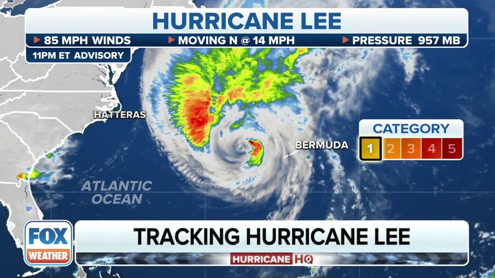
Where is Hurricane Lee?

(FOX Weather)
As of the latest NHC advisory, Hurricane Lee is located about 170 miles west of Bermuda and about 590 miles south of Nantucket, Massachusetts. Hurricane Lee is moving to the north at 14 mph with maximum sustained winds of 85 mph, making it a Category 1 hurricane on the Saffir-Simpson Hurricane Wind Scale.
Due to its proximity to Bermuda, a Tropical Storm Warning is in effect for the island and tropical storm conditions are being seen across the British island territory.
The NHC says Hurricane Lee is continuing to weaken but will remain a "large and dangerous hurricane" as it continues to spin off to the north.
What is the forecast track for Hurricane Lee?

(FOX Weather)
Based on the hurricane's heading, Maine and provinces in Canada are expected to see the worst of the weather but because of the width of the storm, impacts will be felt hundreds of miles from the center.
Coastal communities from Florida to Maine have already impacts from the hurricane in the form of rough seas and the Fernandina Beach Police Department in Florida said it found the body of a swimmer who was taken under by the rough currents.
The heart of the hurricane was more than 700 miles away when the swimmer likely encountered a rip current and did not resurface while in the ocean along Northeast Florida.
FLORIDA COMMUNITY REPORTS FIRST FATALITY CONNECTED TO HURRICANE LEE
What watches or warnings are in effect due to Hurricane Lee in the U.S.?

(FOX Weather)
Tropical storm and hurricane alerts have been issued for millions of people from New England to Canada.
A Tropical Storm Warning is in effect for every coastal city from Westport, Massachusetts, through the U.S.-Canada border. In addition, a Hurricane Watch is in effect for Downeast Maine.
In Canada, both a Hurricane Watch and a Tropical Storm Warning are in effect for hundreds of miles of coastline in the provinces of Nova Scotia and New Brunswick.
A Tropical Storm Warning is issued when tropical-storm-force winds (sustained winds of 39 to 73 mph) are expected within the storm warning area within 36 hours. These winds could be accompanied by a storm surge, coastal flooding and/or river flooding.
A Tropical Storm Watch is issued when tropical-storm-force winds are possible within the storm watch area, generally within 48 hours.
A Hurricane Watch is issued when hurricane-force-winds (sustained winds of 74 mph or greater) are possible within the watch area, generally within 48 hours.
What will Lee's impact be in New England?
Hurricane Lee is expected to bring strong, possibly damaging wind gusts to the coastal regions of New England along with massive surf and heavy rain starting on Friday.
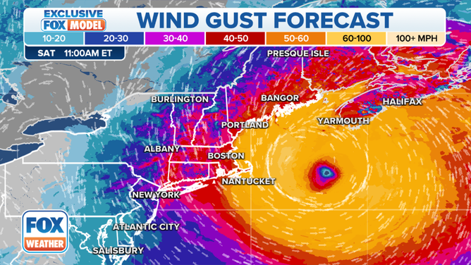
The FOX Forecast Center expects Lee’s wind field to extend about 560 miles across, which would make impacts far-reaching in New England.
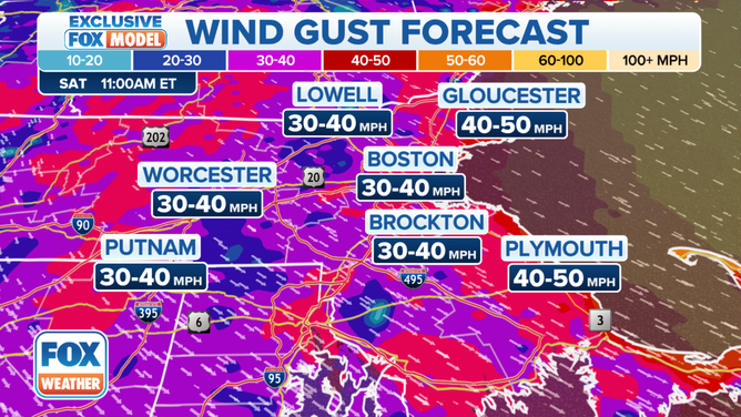
Winds could be whipping to between 30 and 40 mph from the Boston Area to Worcester and in northeastern Connecticut.
On the South Shore of Massachusetts, winds will be a bit stronger and could reach to between 40 and 50 mph on Saturday morning.
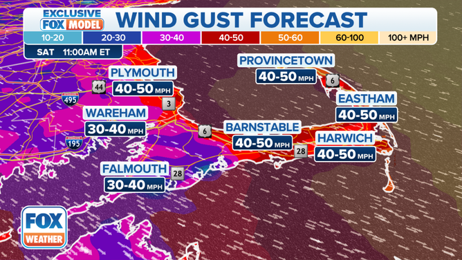
Strong wind gusts are also expected across Cape Cod from Barnstable to Provincetown.
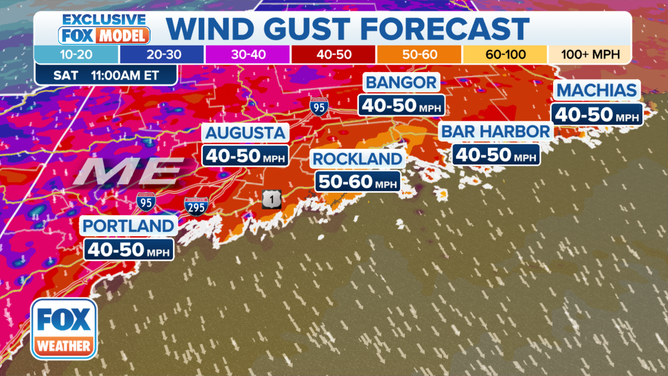
And in Maine, winds could gust to between 50 and 60 mph along the coast, including Rockland.
HURRICANE LEE TIMELINE TRACKER: WHEN AND WHERE TO EXPECT IMPACTS IN NEW ENGLAND, MAINE
![The potential wind gusts from Hurricane Lee on Saturday, September 16, 2023.]() Image 1 of 4
Image 1 of 4The potential wind gusts from Hurricane Lee on Saturday, September 16, 2023. ( )
![The potential wind gusts from Hurricane Lee in the Boston area on Saturday, September 16, 2023.]() Image 2 of 4
Image 2 of 4The potential wind gusts from Hurricane Lee in the Boston area on Saturday, September 16, 2023. ( )
![The potential wind gusts from Hurricane Lee on Cape Cod on Saturday, September 16, 2023.]() Image 3 of 4
Image 3 of 4The potential wind gusts from Hurricane Lee on Cape Cod on Saturday, September 16, 2023. ( )
![The potential wind gusts from Hurricane Lee in Maine on Saturday, September 16, 2023.]() Image 4 of 4
Image 4 of 4The potential wind gusts from Hurricane Lee in Maine on Saturday, September 16, 2023. ( )
"This is not a ‘pack up your stuff and get out’ (storm)," Merwin said "This is a hunker down, get ready to lose power. We're going to have really nasty conditions on Saturday, and then we'll wake up on Sunday and it will be a new day."
Most of the heavy rain is expected to fall over Atlantic Canada, but depending on Hurricane Lee's track a few inches of rain could fall in New England.
Coastal regions from Massachusetts to Maine will see the highest rain totals, with Massachusetts, New Hampshire and most of Maine seeing about 1-2 inches, with higher amounts along coastal areas of eastern Massachusetts, including Cape Cod. Downeast Maine could also see more, with forecast totals between 2-5 inches.
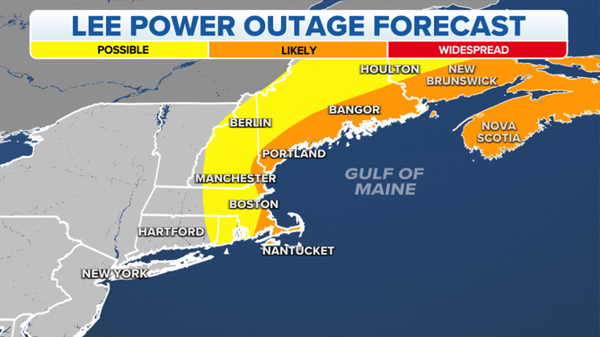
A map showing the potential power outages from Hurricane Lee.
(FOX Weather)
People living in New England still have a day to prepare for any potential impacts and power outages Lee will have on the region before the weather starts to deteriorate on Friday.
"We can still see a 24-hour stretch where you might be without power which means everything in your fridge will go bad," Merwin said. "Your food can’t last 24 hours without power to your fridge. So, maybe buy a couple of things at the store over the next couple of days that you can eat and not have to worry about having it refrigerated."