Bryan Norcross: Hurricane Lee's impacts will increase as it heads north along the US East Coast this week
The track will likely be between the U.S. East Coast and Bermuda. Though the exact path north is unclear, the bigger uncertainty is what happens after the hurricane passes Bermuda and is offshore of the mid-Atlantic states.

FOX Weather is your Hurricane HQ, streaming free 24/7.
(FOX Weather / FOX Weather)
Updated at 9:20 a.m. on Monday, September 11, 2023
Hurricane Lee is strengthening in fits and starts as it strolls across the waters north of Puerto Rico and the surrounding islands. This leisurely forward motion is expected to continue for a couple of days until a dip in the jet stream developing over the Great Lakes reaches down to scoop it up. A river of air will develop between the jet stream dip and high pressure over the Atlantic, which will start to take Lee to the north in earnest on Wednesday.
The track will likely be between the U.S. East Coast and Bermuda. Though the exact path north is unclear, the bigger uncertainty is what happens after the hurricane passes Bermuda and is offshore of the mid-Atlantic states. On the current schedule, that would be about Friday.
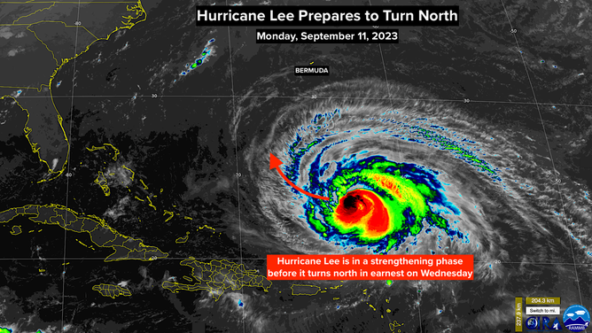
NOAA satellite captures Hurricane Lee
(NOAA)
Watches and warnings will likely be issued for Bermuda late tomorrow or Friday.
The jet stream dip is forecast to pass Lee by on Friday, making room for a weak bubble of high pressure north of the hurricane to affect the storm’s path before another dip comes along. The weak high could deflect Lee toward the New England coast. All this could result in Lee's track having an S-like shape. Although the curves would be slight, as things look right now, any zigging to the left would bring stronger winds near or over the coastline in parts of the Northeast, New England, and Atlantic Canada.
Anytime a strong storm parallels a coastline, knowing the exact direct impacts very far in advance is impossible. The slightest angle difference in the track can change whether the worst weather stays offshore or rakes the coast. It's too early to know how strong the winds on land will be, but the odds of at least some impacts are increasing based on the latest long-range computer forecasts.
Regardless of the exact track, the energy from the hurricane will surge through the ocean and affect the entire East Coast. The waves at the coast should begin to take on a different character with more undertow and a high likelihood of rip currents by tomorrow in the Southeast. The surge of energy in the water will propagate north, peaking in the mid-Atlantic about Friday and in New England over the weekend. Watch for alerts for high water and dangerous conditions at the beach.
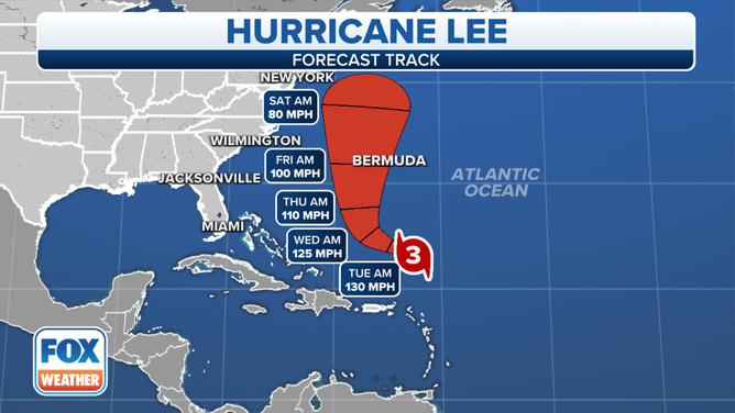
The forecast track for Hurricane Lee on Monday, September 11, 2023.
(FOX Weather)
The degree of any direct impacts on land from Hurricane Lee's high winds is unknowable this far in advance. What we do know is that the diameter of the strongest winds in the storm will be expanding. If some part of the U.S. coastline were directly affected by the strong winds, some or all of the coast from eastern Long Island, New York to northern Maine would seem to be the areas most likely threatened based on what we know now.
This will be a slow-motion event with impacts increasing through the week, peaking at the end of the week or over the weekend. The only thing to do right now is to stay informed. Residents along or near the Northeast or New England coast might have to take action later this week. Be sure you're receiving the latest forecasts and look for instructions from local officials.
Hurricane Lee is back up to Category 3 strength, but that's not especially relevant to the future of the storm. It will likely be slowly weakening but expanding in size as it moves north during the second half of the week. Don't be fooled by lowering top-wind numbers in the forecast. The large-diameter storm will put a tremendous amount of energy in the ocean.
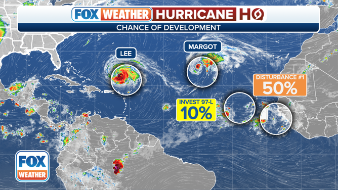
An overview of the tropical Atlantic Ocean on Monday, September 11, 2023.
(FOX Weather)
Elsewhere in the Atlantic, Tropical Storm Margot is still on track to become a hurricane in the next few days before it eventually dies out in the open ocean.
A Tropical Disturbance that moved off Africa yesterday has a good chance of developing into a tropical depression or tropical storm in the next several days as it treks across the tropical Atlantic. The next name on the list is Nigel.
Along the way, eventually-Nigel is expected to absorb a separate small disturbance, which will add to its available moisture. In any case, the storm is not expected to threaten land this week. We'll keep an eye on it.