Days of rain, flooding to soak millions as spring severe weather pattern kicks off across Plains, Central US
Warm temperatures spreading across the eastern two-thirds of the country is enhancing severe weather across the Central U.S., as well as fuel storms in the Great Lakes and Mid-Atlantic.

Days of severe weather begin in the Mid-Atlantic with gusty winds and thunderstorms
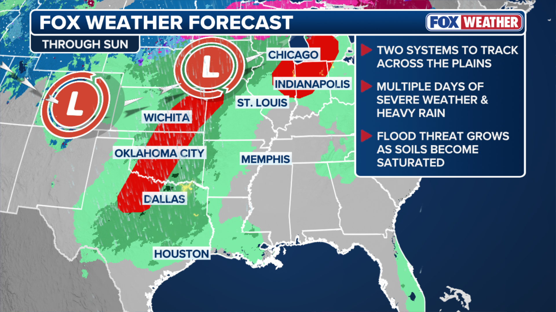
Millions of people are under a severe weather threat across the Plains, Midwest, Ohio Valley, and the Mid-Atlantic on Wednesday. Hail, gusty winds, scattered thunderstorms, and possible tornadoes are expected. This is just the first of several days of severe storms that will last through Saturday.
More than 52 million people are under a severe weather threat across parts of the Plains, Midwest, Ohio Valley and the Mid-Atlantic on Wednesday, the first of several days of storms expected to last through the weekend — setting the stage for potential flash flooding.
This active severe weather pattern comes right on cue, as April is historically when spring severe weather season begins to intensify across the middle of the country.
MEET THE ASTRONAUTS PREPARING FOR HUMANITY’S RETURN TO THE MOON ON THE ARTEMIS II MISSION
(FOX Weather)
A dip in the jet stream is acting as an atmospheric conveyor belt for storms moving out of the West.
Warm temperatures spreading across the eastern two-thirds of the country are also enhancing severe weather across the Central U.S. and fueling storms in the Great Lakes and Mid-Atlantic.
On Tuesday, severe storms dropped quarter-sized hail across parts of Iowa and Illinois, while wind gusts reached 75 mph across Ohio, western Pennsylvania and western New York, according to the National Weather Service (NWS).

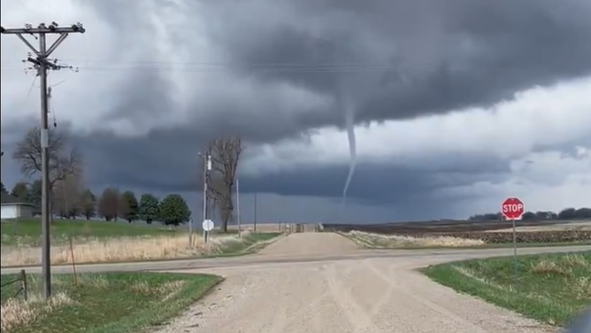
Tornado rolls along the ground in Missouri Valley, Iowa.
(Brandon Copic / FOX Weather)
Spring severe weather season begins across Central U.S.
A cold front moved through and stalled over the Plains on Wednesday, and severe storms are supposed to fire along a dryline — the boundary between dry air from the west and warm, moist air from the Gulf — forecast to set up over southern, central Kansas, western Oklahoma and the Red River Valley in North Texas.
NOAA's Storm Prediction Center issued a Level 3 out of 5 risk of severe thunderstorms for this corridor as storms started up between 3 and 6 p.m. CT.
According to the FOX Forecast Center, these storms may produce large, egg-sized hail. Storms organized into a line this evening as the threat shifted to damaging wind gusts and potentially strong tornadoes (EF-2+).

(FOX Weather)
A broader Level 2 threat stretches from northern Missouri cutting southeast across the Southern Plains through San Angelo, Texas, to the U.S.-Mexico border. Dallas is under a Level 1 threat.
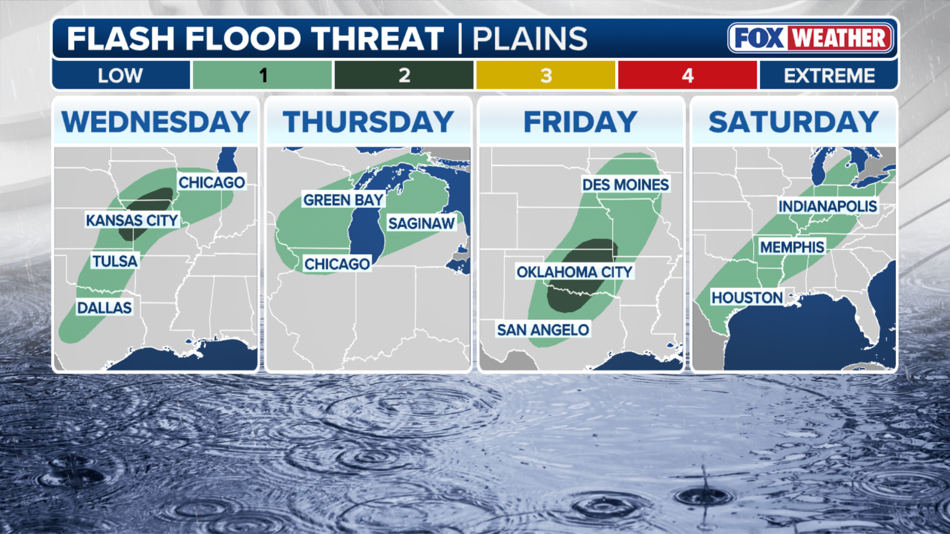
In addition to the severe weather hazards, the FOX Forecast Center noted that the significant moisture in the atmosphere due to warmer temperatures will drive days of potential flash flooding.
GRAND CANYON NATIONAL PARK ENTERS STAGE 3 WATER RESTRICTIONS FOLLOWING ANOTHER SOUTH RIM PIPE BREAK
"These storms will have plenty of fuel to produce heavy rain," the Forecast Center said.
The greatest risk of flash flooding will be across parts of eastern Kansas, western Missouri and northern Oklahoma.
(FOX Weather)
The warm front may also create more storms — which could produce gusty winds and tornadoes — across parts of northwest Kansas and nearby areas.
WHAT FLOOD WATCHES, WARNINGS AND EMERGENCIES REALLY MEAN
Warm temperatures fuel severe weather across the Ohio Valley and Mid-Atlantic
In the Ohio Valley and Mid-Atlantic, storms will continue to develop across the warm front, which will act like a track for storms to repeatedly move along over the next couple of days, with the main concerns being large hail, damaging wind gusts and heavy rain.
Severe storms moved through Illinois, Indiana and the Ohio Valley early Wednesday, while thunderstorms lingered over Pennsylvania.
According to the FOX Forecast Center, the greatest potential for stronger storms is along a narrow corridor from West Virginia into North Virginia and then into parts of Maryland.
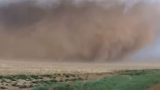
Tornado rolls across Texas.
(Brandon Copic / FOX Weather)
Stretch of severe storms continues across the Midwest and Great Lakes
This system will track into the Midwest and Great Lakes on Thursday, as a strengthening area of low pressure will lift from the Plains into the region. The system will rapidly destabilize the atmosphere by that afternoon, setting the stage for storm development.
A Level 3 severe storm risk is in place for Iowa, Wisconsin, and Illinois, while Milwaukee, Chicago, Davenport, and St. Louis are the greatest risk.

(FOX Weather)
Damaging winds and large hail are possible. Some areas may also experience an EF-2 or stronger tornadoes.
Overnight storms are likely, bringing heavy rain into the Ohio Valley by early Friday. Flash flooding is possible across Wisconsin, Michigan and northern Illinois. Widespread rainfall of 1 to 2 inches is expected.
APRIL SNOW OUTLOOK: COLD BLAST BRINGS ICE AND SNOW BACK TO MIDWEST, PLAINS, AND NORTHEAST
Storm threat reignites across the already hard-hit Plains and Midwest region
Meanwhile, the next severe weather system will move into the Plains and the Midwest by Friday. A Level 3 threat covers parts Iowa and Missouri, while a Level 2 threat is in place for parts of Kansas and Oklahoma.
It is forecast that the storms will cause damaging winds, large hail and tornadoes. The greatest severe risk is expected across Iowa and northern Missouri, where the strong instability, ample wind shear and strengthening low pressure will fuel supercells capable of producing tornadoes.
(Trooper Paul Gardner / Iowa State Patrol / FOX Weather)
The system will create powerful storms overnight that will increase the threat of powerful winds in Kansas and Oklahoma.
Additionally, a dryline extending across western Oklahoma and Texas will likely support isolated severe storms.
All told, 2 to 3 inches of rain is possible from Dallas to Kansas City. A Level 2 out of 4 flash flood risk is in place until Saturday morning.
STRONG WINDS, DRY AIR EXPAND FIRE THREAT FROM THE PLAINS INTO THE ROCKIES AS SOUTHEAST RISK EASES
Stay with FOX Weather as this severe weather threat continues to unfold across the country.