April snow outlook: Cold blast brings ice and snow back to Midwest, Plains, and Northeast
Several different storm systems will track across the Midwest and New England and tap into the cold air, which will deliver several rounds of snow and ice.

Snow and ice target Northern Tier, with over half a foot of snow possible in some areas
Spring may be here, but winter isn’t done yet. Through Saturday, below-average temperatures are setting the stage for rounds of snow and potentially ice across the Upper Midwest and New England—likely impacting Easter travel. Stick with FOX Weather for the latest updates.
Even as April begins, snow and other winter weather will return for millions across parts of the Northern Plains, Upper Midwest and New England. Despite a major warmup set to take hold across much of the Plains, cold air from Canada will maintain its grip across the Northern Tier, setting the stage for several rounds of winter weather through the week.
STRONG WINDS, DRY AIR EXPAND FIRE THREAT FROM THE PLAINS INTO THE ROCKIES AS SOUTHEAST RISK EASES
![]() Image 1 of 3
Image 1 of 3Snow falling in Frederic, Michigan, on Sunday, March 15, 2026. (Morgan Stahl)
![]() Image 2 of 3
Image 2 of 3Snow falling in Marquette, Michigan, on Sunday, March 15, 2026. (Robert Ray)
![]() Image 3 of 3
Image 3 of 3Snow falling in Marquette, Michigan, on Sunday, March 15, 2026. (Robert Ray)


While April snow is not uncommon across these regions, this winter flashback will serve as a significant drop in an ongoing temperature roller coaster, with highs reaching the 70s in Minneapolis and Chicago and conditions in the 60s across New England on Monday.
Several different storm systems will track across the Midwest and New England and tap into the cold air, which will deliver several rounds of snow and ice.
WEATHER WHIPLASH: SPRING TEMPERATURES QUICKLY REPLACED BY WINTER-LIKE COLD BLAST
Northern Plains & Upper Midwest
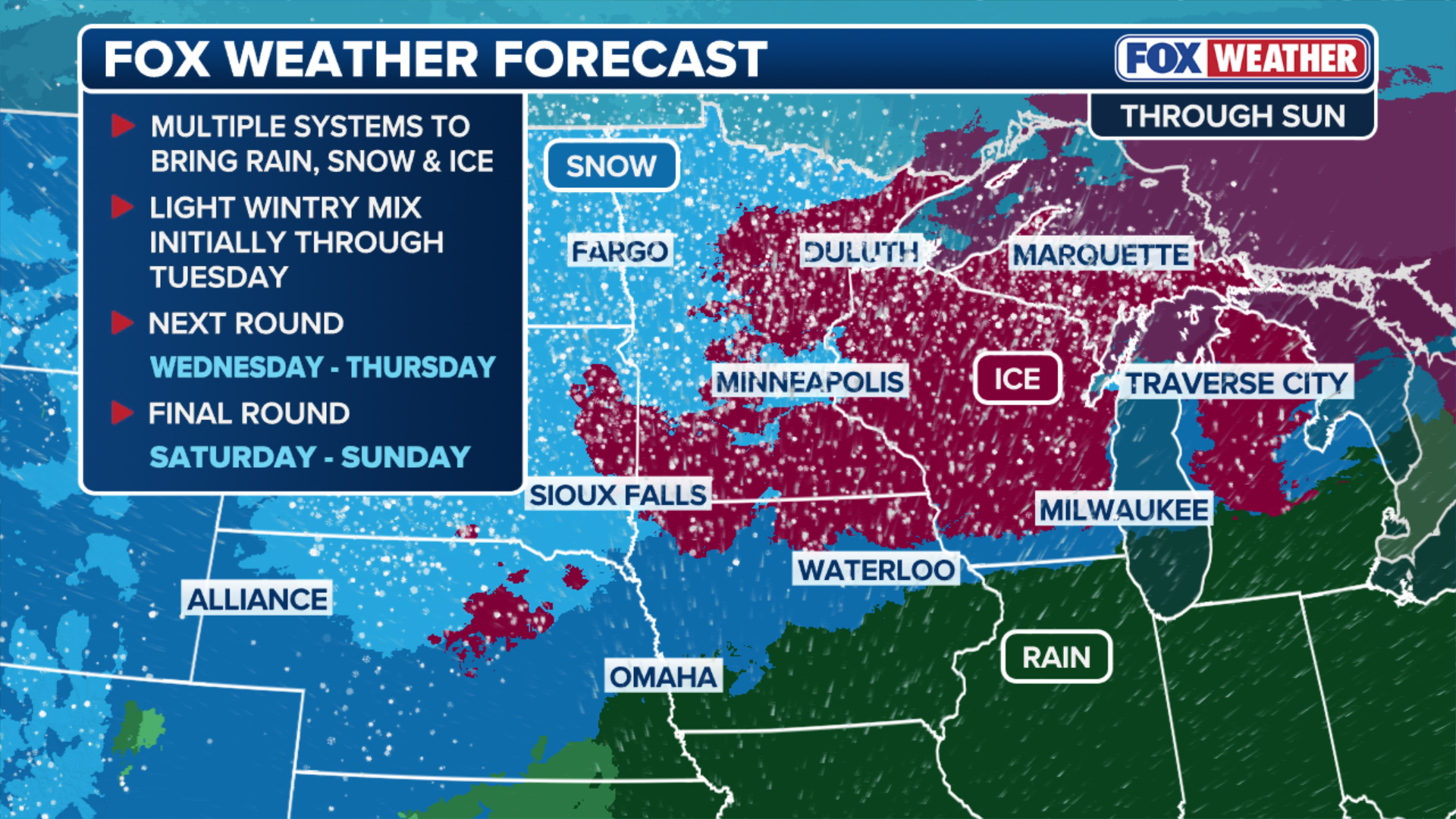
Light snow could break out across northern Minnesota on Tuesday, bringing snow or a wintry mix to places like Duluth, ahead of the first winter storm which is expected to reach the region by midweek.
Winter Weather Advisories are in effect for parts of Minnesota through early Tuesday afternoon for a light glaze of freezing rain that could impact morning and early afternoon commutes.
(FOX Weather)
According to the FOX Forecast Center, freezing rain and sleet are expected to begin Wednesday evening across parts of the Dakotas, Nebraska, and southwest Minnesota, before spreading into Wisconsin and parts of Michigan, generally north of Interstate 96 and 69 corridors by early Thursday.
This will impact the Minneapolis and Marquette, Michigan metro areas, coming just two weeks after a record blizzard blasted Michigan's Upper Peninsula.
HISTORIC BLIZZARD BURIES MARQUETTE, MICHIGAN IN 3 FEET OF SNOW
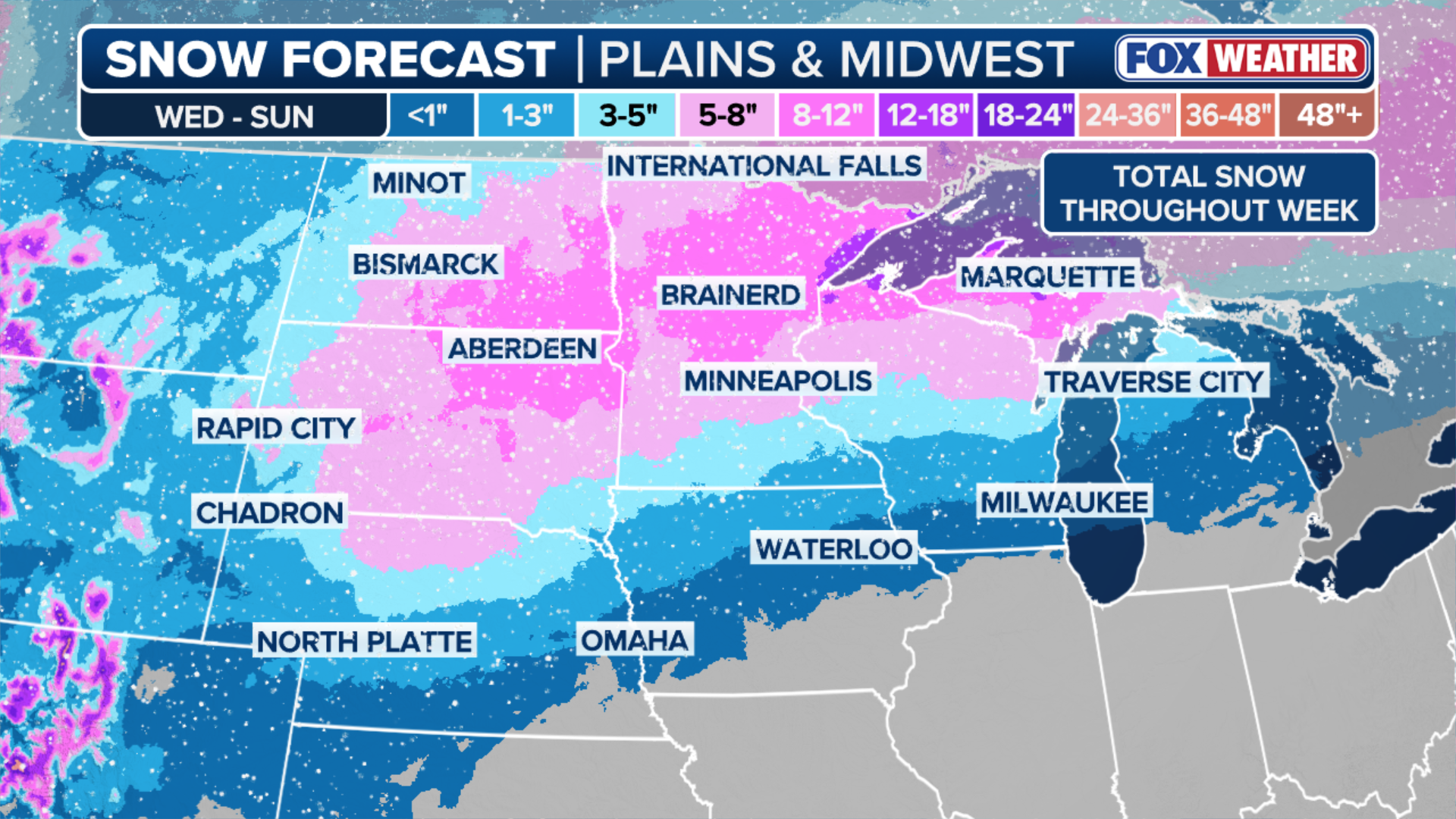
A widespread area of 3–5 inches of snow is expected, with localized pockets of up to 8 inches of snowfall through Thursday.
(FOX Weather)
A second winter storm will follow closely behind, reaching the Dakotas and Minnesota by Friday and shifting east through the weekend, with snow lingering into Sunday.
This second winter blast will also pack wind gusts between 30 and 40 mph, leading to periods of whiteout driving conditions.
All told, parts of northern Minnesota and Michigan's Upper Peninsula could see more than a foot of snow total.
MEET THE ASTRONAUTS PREPARING FOR HUMANITY’S RETURN TO THE MOON ON THE ARTEMIS II MISSION
New England
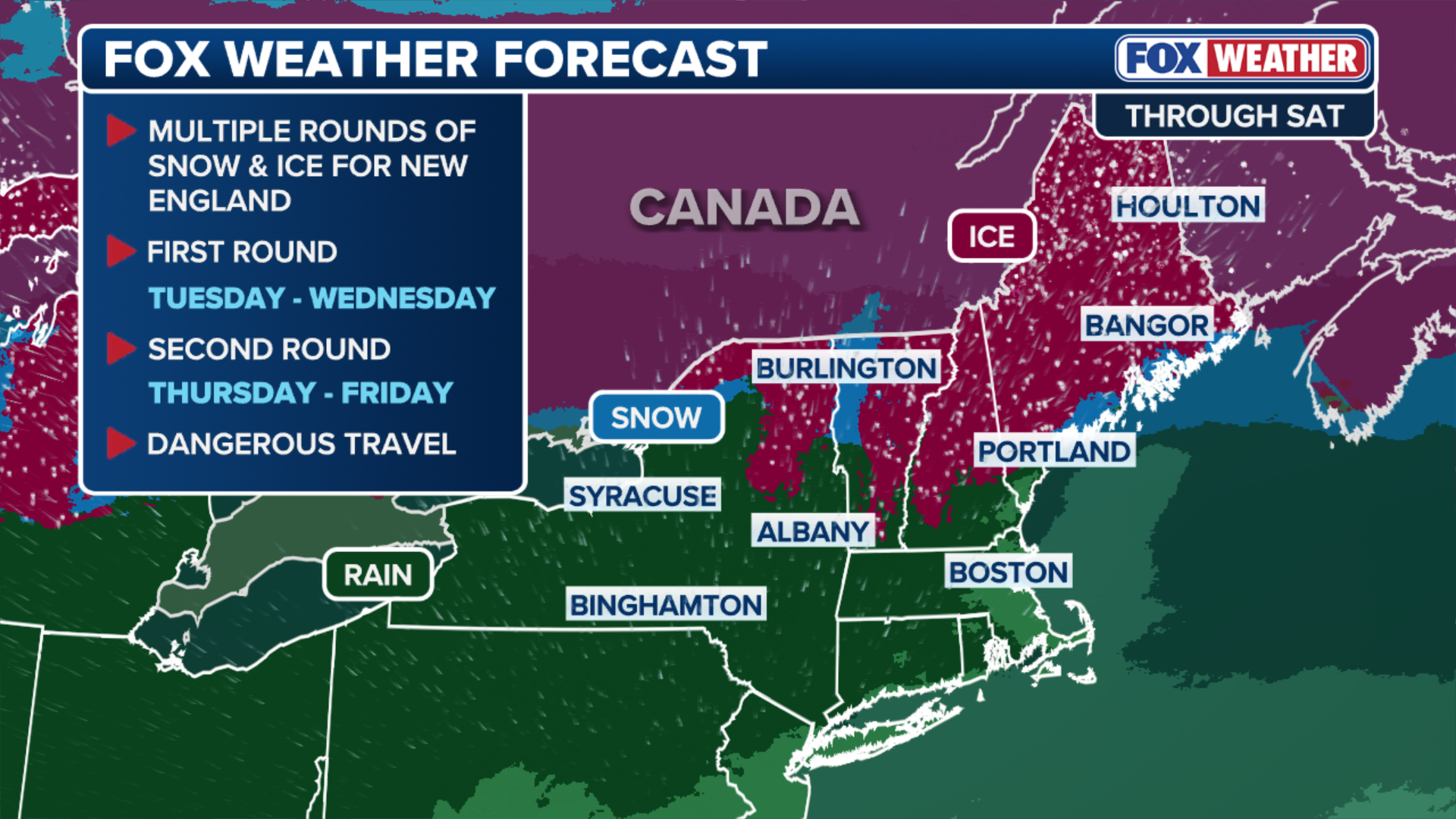
A different storm system will harness the cold Canadian air over New England beginning Tuesday and lasting through Wednesday, set to deliver a mix of snow and freezing rain across New York's North Country, as well as the Berkshires, Green Mountains and White Mountains.
(FOX Weather)
After this system exists east, the first system from the Midwest will arrive on Thursday, bringing snow, ice and sleet to the same parts of Northern New England and last into Saturday.
Cold air trapped near the ground will make it easier for ice to build up, weighing down power lines with the potential to cause widespread outages.
WHAT ARE ICE STORMS AND WHY ARE THEY DANGEROUS?
"Areas of most concern will be those low-lying areas in Maine, Vermont and New Hampshire where there is a level of melting between the cold layers," the FOX Forecast Center said.

(FOX Weather)
In addition, ice is expected to create dangerous road conditions, particularly when precipitation refreezes overnight.
A widespread coating to three inches of snow is expected across northern New England between Wednesday and Sunday. But depending on where the snow and ice line sets up, parts of northern Maine could pick up double-digit snow totals.