Atlantic hurricane season ranked 4th for most-named storms in a year despite El Nino
This year's above-average hurricane season was a bit of a surprise, characterized by record-warm Atlantic sea surface temperatures and a strong El Niño, according to NOAA.
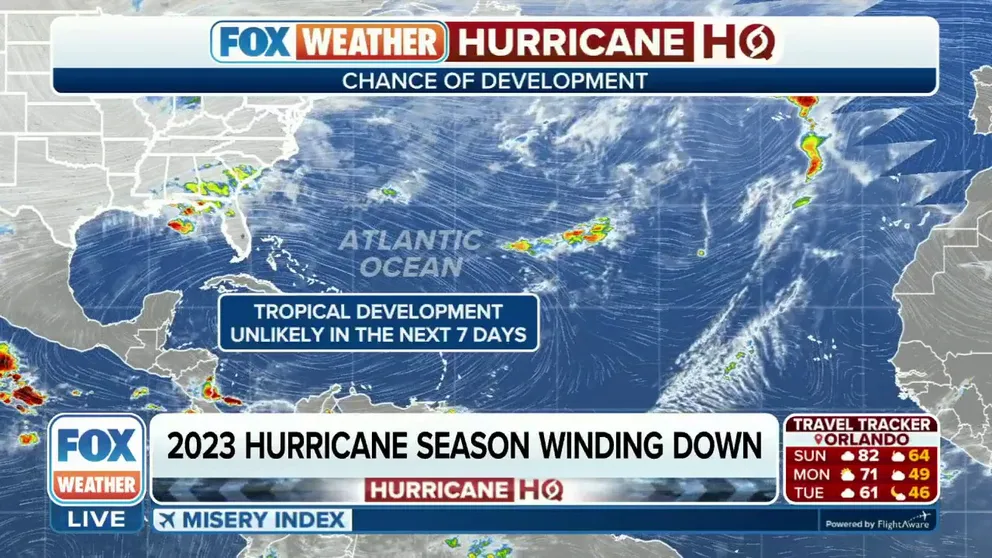
2023 hurricane season winding down
Tropical Storm Ramon has fizzled in the Eastern Pacific Ocean, leaving both the Atlantic and Eastern Pacific basins without any tropical activity as we kick off the final week of the 2023 hurricane season.
MIAMI - If you thought this year’s hurricane season felt busier than usual, NOAA says you’d be right. 2023 just ranked as among the top most active seasons, with 20 named storms.
That’s the fourth-most named storms since record-keeping began in 1950, NOAA announced on Tuesday.
An average season sees 14 named storms, which would be tropical storms that obtain maximum sustained winds of at least 39 mph.
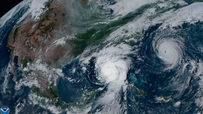
NOAA's GOES-16 satellite captured Hurricane Idalia approaching the western coast of Florida while Hurricane Franklin churned in the Atlantic Ocean at 5:01 p.m. EDT on August 29, 2023.
(NOAA Satellites / NOAA)
This year's above-average hurricane season was a bit of a surprise, characterized by record-warm Atlantic sea surface temperatures and a strong El Niño, according to NOAA. El Niño cycles traditionally hinder tropical development in the Atlantic due to an increase in hostile wind patterns, but not this year.
HOW EL NINO, ‘FREAKISH’ WARM OCEANS FACTOR INTO HURRICANE SEASON
"The Atlantic basin produced the most named storms of any El Niño-influenced year in the modern record," said Matthew Rosencrans, lead hurricane forecaster at NOAA’s Climate Prediction Center. "The record-warm ocean temperatures in the Atlantic provided a strong counterbalance to the traditional El Niño impacts."

(FOX Weather)
Of the 20 storms produced in the Atlantic during the 2023 hurricane season, seven strengthened to become hurricanes with maximum sustained winds of at least 74 mph.
Plus, three intensified to become major hurricanes, defined as storms that grew to become Category 3 or higher with maximum sustained winds of at least 111 mph.
That fell in line with the average hurricane season, which sees seven hurricanes and three major hurricanes.
Some notable storms of 2023

A satellite image of Hurricane Idalia on Wednesday, August 30, 2023.
(NOAA)
Despite the large number of named storms, only one hurricane made landfall in the U.S.: Hurricane Idalia, which came ashore in the Big Bend of Florida on Aug. 30. Idalia caused storm surge of up to 12 feet and caused widespread flooding from rainfall across Florida, Georgia and the Carolinas.
DRAMATIC PHOTOS, VIDEOS CAPTURE HURRICANE IDALIA'S HISTORIC LANDFALL IN FLORIDA
On Sept. 16, what was Hurricane Lee made landfall in Nova Scotia, Canada, as a post-tropical cyclone, or a cyclone that no longer has a warm core or other tropical characteristics. Prior to landfall, Lee had reached a Category 3 hurricane status off the U.S. East Coast and, as it made its way north to Canada, its powerful winds created dangerous surf and rip currents along the Mid-Atlantic and New England coastlines.

Winds from Lee brought down a large tree in Maine that crashed through the windshield of a van, narrowly missing the driver and his passengers.
(Maine State Police/Facebook / FOX Weather)
A week after Lee, Tropical Storm Ophelia made landfall on Emerald Isle, North Carolina, as a strong tropical storm with 70 mph winds. Ophelia brought widespread rainfall, gusty winds, along with storm surge and river flooding in parts of the Tar Heel State, NOAA said.
Pacific Ocean basin had a busy hurricane season, too
While the Atlantic Ocean produced an above-average number of storms this hurricane season, so too did the eastern Pacific Ocean with 17 named storms, according to NOAA.
One of those storms was Tropical Storm Hilary, a rare tropical storm that brought impacts to the West Coast of the US. What was a Category 4 hurricane out at sea, Tropical Storm Hilary made landfall in Baja California, Mexico, and made its way northward to the Golden State.

An image showing catastrophic flooding in Palm Springs, California, due to the effects of Tropical Storm Hilary on Sunday, August 20, 2023.
(Clement - Petramala / LSM)
The deadly storm caused flooding and mudslides and prompted officials to issue the first Tropical Storm Warning for Southern California.
Another historic storm was Hurricane Otis, which struck southwestern Mexico. With maximum wind speeds of 165 mph, Otis made history on Oct. 25 when it became the strongest hurricane to make landfall on the Pacific side of Mexico.

View of the damage caused after the passage of Hurricane Otis in Acapulco, Guerrero State, Mexico, on October 25, 2023.
(FRANCISCO ROBLES/AFP / Getty Images)
The Category 5 hurricane destroyed buildings, produced heavy rainfall and caused flooding and storm surge. According to officials, Otis caused the deaths of at least 48 people.
Tracking the 2023 hurricane season
During the 2023 hurricane season, NOAA said the agency's Hurricane Hunter aircraft flew 468 mission hours to collect atmospheric data that is critical to hurricane forecasting and research.

A WP-3D Orion airplane used by NOAA's Hurricane Hunters is seen during a stop in Houston, Texas, on May 1, 2023.
(Aaron Barker / FOX Weather)
Hurricane Hunters are pilots, aircraft and researchers that fly into tropical cyclones. In 2023, Hurricane Hunters passed through the eyewalls of hurricanes 120 times and deployed more than 1,400 scientific instruments that gathered data about the storms, NOAA said.
They noted that since 2020 through this 2023 season, NOAA’s two Lockheed WP-3D Orion planes, the robust class of aircraft that fly into storms, have flown 40% more hurricane mission flights than the preceding four years (2016-2019).

The hurricane hunters took a flight inside the eye of Category 5 Hurricane Lee in September.
(Hurricane Hunters / FOX Weather)
The official hurricane season for the eastern Pacific basin runs from May 15 through Nov. 30, according to NOAA. The official hurricane season in the Atlantic Basin begins a little later on June 1, but also ends on Nov. 30.