Year in review: Shocking satellite images of extreme weather seen from space
Here are five of the most significant weather events that satellites were able to capture in action in 2025.

Satellite images show neighborhoods engulfed in smoke from LA fires
Satellite imagery from Planet Labs PBC captured on Thursday showed Los Angeles neighborhoods engulfed in smoke from the Palisades and Eaton fires as flames began to consume houses. Nearly 30,000 acres of land has been burned in the wildfires around Los Angeles, with over 10,000 structures destroyed, according to Cal Fire. The fires have left at least 10 people dead.
It has been an active year across the U.S., with much of the country experiencing at least one major weather event.
Numerous locations have faced flash floods, wildfires, hurricanes, tornadoes or even volcanic eruptions, causing widespread destruction in some areas.
A few of these weather events were captured by satellite images from space.
STATE OF EMERGENCY DECLARED ACROSS LOS ANGELES METRO AMID 'HIGH RISK' CHRISTMAS EVE FLOODING
But as 2025 comes to an end, here's a look back at a year that was defined by nature’s extremes.
Here are five of the most significant weather events that satellites were able to capture in action in 2025.
Palisades and Eaton fires

Satellite imagery shows scope of California disaster
Before-and-after images released by Maxar, a space technology company based in Colorado, showed areas particularly hard hit by the Palisades and Eaton fires.
These horrific fires began at the start of 2025 on Jan. 7 in Los Angeles County. Fueled by a dry landscape and powerful Santa Ana winds, the Palisades and Eaton fires rapidly spread across California neighborhoods, including the Pacific Palisades, Topanga, Malibu and Altadena.
The fires killed at least 28 people and destroyed more than 16,000 structures. Hundreds of thousands of people were displaced or forced to evacuate their homes.

Firefighters work to put out a fire that broke out at the Altadena Golf Course Jan. 9, 2025.
(Barbara Davidson for the Washington Post / Getty Images)
These fires have become known as the two of the most destructive wildfires in recent California history.
It is estimated that the Palisades and Eaton fires caused between $50 billion and $250 billion in damage.
Texas flash flood

This image shows the aftermath of the flash floods that impacted Central Texas in July.
(Satellite image ©2025 Vantor. / FOX Weather)
In the early hours of July 4, extremely heavy rain fell across central Texas, triggering catastrophic flash floods.
The slow-moving storm system caused torrential rain, with some areas receiving more than 20 inches in hours, leading to many rivers rapidly rising, particularly the Gaudalupe River.
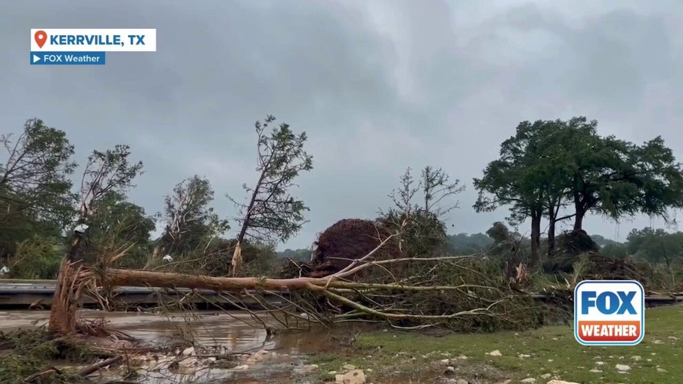
Kerrville floods leave behind trail of devastation in Texas
Kerrville floods leave behind a trail of devastation in Texas, where at least 27 people are dead and many more still unaccounted for as of Saturday afternoon.
At least 135 people were reported killed, with 117 of those deaths occurring in Kerr County. Among the hardest hit was Camp Mystic, located along the Guadalipe river, where dozens of campers and counselors tragically died when the floodwaters swamped the area unexpectedly.
The Central Texas floods are one of the deadliest flash flooding disasters in modern U.S. history.
Flood damage in Alaska
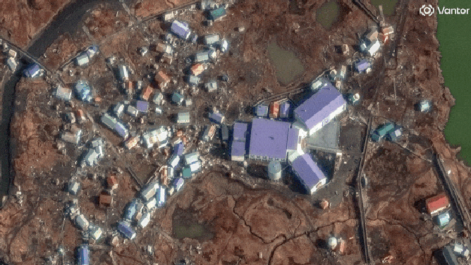
Before and after photos from Vantor showing the damage left behind by floods in Alaska from October 2025.
(Satellite image Copyright 2025 Vantor / FOX Weather)
In early October, the remnants of Typhoon Halong slammed the southwest coast of Alaska, bringing wind gusts of up to 100 mph, storm surges and widespread coastal flooding to numerous Alaska Native villages.
The storm caused mass destruction, sweeping homes off their foundations. In some cases, families were still inside.
About 109 homes out of the 176 in the village of Kipnuk flooded to the point they were swept out to sea.
The storm killed at least one and displaced thousands of residents.
Homes collapse on North Carolina’s coast

Barriers were placed along the shoreline after 16 houses collapsed in Buxton, N.C. due to beach erosion.
(Satellite image ©2025 Vantor / FOX Weather)
Beginning in mid-September, 16 unoccupied homes collapsed along North Carolina’s Outer Banks after back-to-back hurricanes and coastal storms.
Many of the homes that had collapsed were only a few hundred feet away from the ocean’s shoreline and were impacted by coastal erosion.
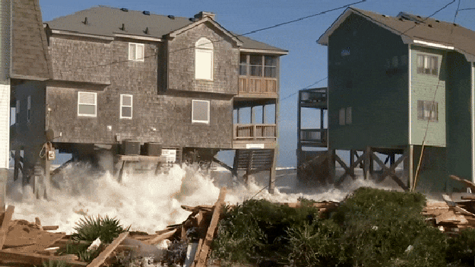
An eighth home collapses in Buxton, North Carolina in rough surf on Oct. 2, 2025.
(FOX Weather)
The collapsed homes scatter debris, septic waste and hazardous materials across beaches and into the ocean, creating hazards for people and wildlife.
There was so much debris that the Cape Hatteras National Seashore had to haul more than 400 truckloads from the fallen houses.
Hurricane Melissa
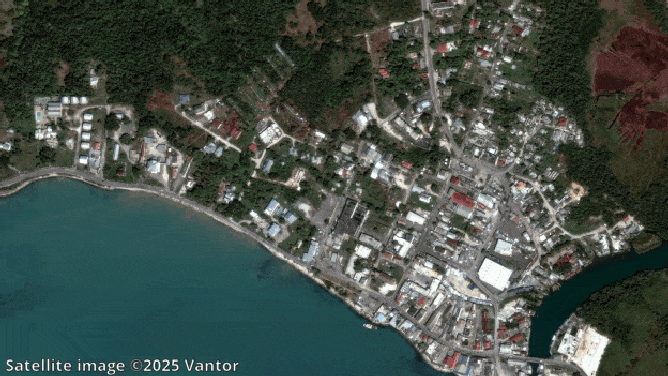
Before and after videos from various locations in Jamaica from Hurricane Melissa.
(Satellite image ©2025 Vantor / FOX Weather)
Hurricane Melissa was one of the most powerful Atlantic hurricanes on record and the strongest to ever hit Jamaica.
The storm formed in the Atlantic in mid-October, where it quickly intensified to a Category 5 storm.
It made landfall on Oct. 28 near New Hope, Westmorland, Jamaica with sustained 185 miles per hour winds.
HURRICANE MELISSA KILLS OVER TWO DOZEN IN CARIBBEAN AFTER CATASTROPHIC LANDFALLS IN JAMAICA, CUBA

An aerial view shows destroyed buildings following the passage of Hurricane Melissa in Black River, St. Elizabeth, Jamaica, on October 29, 2025. Hurricane Melissa bore down on the Bahamas October 29 after cutting a path of destruction through the Caribbean, leaving 30 people dead or missing in Haiti and parts of Jamaica and Cuba in ruins. Somewhat weakened but still threatening, Melissa will bring damaging winds and flooding rains to the Bahamas Wednesday before moving on to Bermuda late Thursday, according to the US National Hurricane Center (NHC). (Photo by Ricardo Makyn / AFP) (Photo by RICARDO MAKYN/AFP via Getty Images)
(Getty Images)
The storm brought catastrophic winds, torrential rain, strong surge and flooding, destroying homes, knocking out power and isolating communities across the island.
Hurricane Melissa also impacted Cuba, Haiti, Dominican Republic and Bermuda, where heavy rains and high winds caused further destruction.
At least 102 people died from the storm.