US just had its warmest winter in history thanks to El Nino
The El Niño pattern kept frigid temperatures locked up at the poles, giving the U.S. an unusually mild winter that has already seen the country's first billion-dollar disaster.
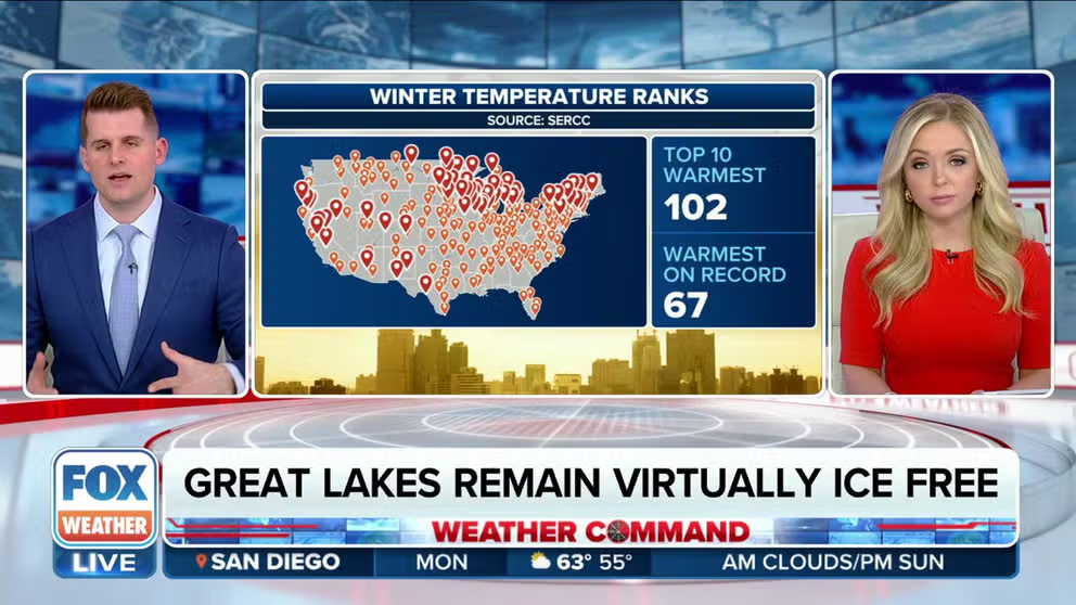
US had warmest winter on record
Winter 2023/2024 goes into U.S. history as the warmest in 130 years of recordkeeping. FOX Weather has details about how El Nino was responsible.
The winter 2023-24 is going down in history as the hottest on record for the contiguous U.S. in 130 years of record keeping, according to NOAA.
During February, record-breaking heat, over the century mark in some cases, baked Texas and much of the central U.S. during what is traditionally one of the coldest months of the year. Killeen, Texas, became the first city to hit 100 degrees for the calendar year on Feb. 26. FOX Weather calculated that 1,327 cities broke daily record highs for the month.
This was also the winter with a record low ice extent across the Great Lakes. As of Feb. 11, only 2.7% of the Great Lakes were covered in ice. On average, 50% of the lakes are covered in ice by that point in winter.
WARM WINTER LEADS TO CONTINUED RECORD-LOW ICE ALONG GREAT LAKES
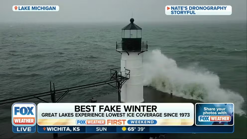
And the award for Fake Winter goes to…
In honor of the Oscars, FOX Weather put together their own weather awards show. For the Best Fake Winter, they awarded the Great Lakes which has seen the lowest ever ice extent across the water.
THIN ICE: LAKES BEAR IMPACTS FROM WARM WINTER
The month of February 2024, came in at the third-warmest on record. The average temperature was 41.1 degrees Fahrenheit (F), which was 7.2 degrees warmer than the 20th-century average.
December 2023 came in as the warmest in 130 years of record-keeping, so it is not a stretch that meteorological winter should go down in the books.
Many parts of the country will remember Christmas 2023 as a Christmas without snow. Only 17.6% of the U.S. was covered in snow as of Christmas morning, the least amount for Christmas Day in at least 20 years, according to the FOX Forecast Center. Christmas in 2009 saw the most snow, with more than 63% of the U.S. covered.
PAGING OLD MAN WINTER? STORY BEHIND THE WINTER THAT WASN'T
Blame El Niño
January saw the polar vortex stumble, which allowed frosty temps to spill as far south as the Gulf Coast but just for a brief amount of time. The month finished 1.6 degrees F above average, so still warmer than average but not a record breaker.
"El Niño played a large role in the record heat," said FOX Forecast Center Meteorologist Cody Braud. "The pattern for El Niño typically means a strong Pacific Jet, which displaces the Polar Jet farther to the North. There are obviously other facets to the story, but this largely keeps the coldest air trapped out of the Lower 48."
TAYLOR SWIFT RETURNS FROM TOKYO ERAS CONCERTS TO MAKE SUPERBOWL WITH HELP FROM POWERFUL JET STREAM
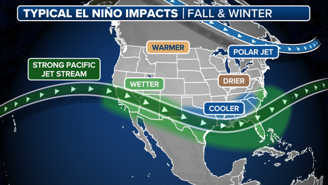
During El Niño, we usually see a stronger Pacific Jet (green) which displaces the Polar Jet (blue) farther north and locks up the frigid temperatures.
(FOX Weather)
Braud said the Pacific Jet has been intensifying over the U.S. over the last couple of months in a southwest-to-northeast orientation.
"This allowed an abundance of warm air to dominate the eastern 2/3 of the country," he said. "Not only that, but it was allowing storms to be mainly rain."
Meteorological winter-ish
The 2023-24 winter was the warmest on record. The average temperature of 37.6 degrees F was 5.4 degrees warmer than average. With 7.71 inches of precipitation, the winter came in 0.92 inches above normal and the third-wettest.
WARM WINTER WEATHER LEADS TO CHAOS IN ENERGY TRADING AS DEMAND CRATERS FOR HEATING
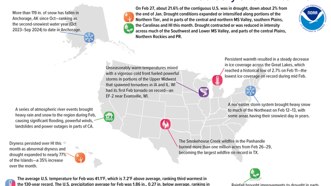
Significant February 2024 weather and climate events.
(NOAA/NCEI / NOAA)
Because of the unseasonably warm weather, 2024 already saw its first weather disaster exceeding $1 billion in losses. Severe storms spawned tornadoes Jan. 8-10 across more than a dozen states. The worst hit areas were the Florida Panhandle, where an EF-3 tornado destroyed much of Panama City Beach. Damaging wind gusts brought destruction along the Eastern Seaboard.
Even though El Niño is weakening, NOAA warns it could hold on through the summer. That could mean above-average temperatures through August.
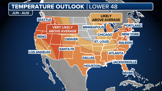
NOAA's summer temperature outlook.
(NOAA)