Early preview: Waning El Nino likely to control summer weather with I-95 corridor at center of heat waves
According to NOAA, the warmest summers on record in the U.S. occurred in 2021 and 1936, when the average temperatures were 2.60 °F during meteorological summer.

Top travel destinations to begin summer
Travel Analyst Francesca Page shares the best destinations and provides the best tips for planning your summer vacation.
An early glimpse of the climate outlook for the upcoming summer shows much of the lower 48 will continue the streak of temperatures that are well above average and precipitation that will be hit or miss except for in the Northeast.
NOAA’s Climate Prediction Center released its updated seasonal outlooks on Thursday that showed the probability of regions seeing above-normal, near-normal and below-normal temperatures and rainfall.
"While El Niño conditions continue with equatorial sea surface temperatures (SSTs) above average across the central and eastern equatorial Pacific Ocean, the total subsurface ocean heat content anomaly across the equatorial Pacific has dropped to near zero, signaling an imminent transition to ENSO-neutral conditions," NOAA forecasters stated.
Complicating outlooks is the waning El Niño, but similar to previous events, extreme heat will likely linger well past the global climate feature's grip.
The combination of weather patterns and heat means that the I-95 corridor could be set up for an extremely warm summer where heat waves will be common.
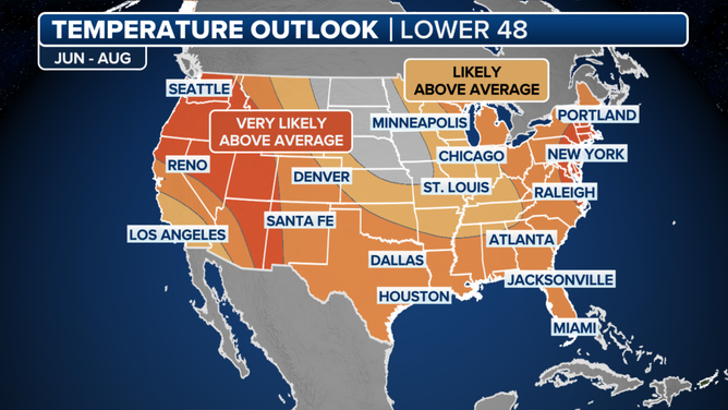
NOAA summer temperature outlook
(NOAA)
The outlook is much different than in 2023 when the region saw only its 35th warmest summer on record.
Other areas that could be subject to seeing above-normal temperatures include the Southwest and Pacific Northwest.
The only section of the country that could be in store for close to average temperatures is the Upper Midwest, which is a flip from the winter pattern when the region experienced some of the warmest anomalies.
EL NINO APPEARS TO BE ON VERGE OF RAPID COLLAPSE
Observed Average Mean Temperature for Dec 1 2023 to Feb 14 2024
(Southeast Regional Climate Center / FOX Weather)
Precipitation could hold the key to how active the weather could be
Less than four months before the start of meteorological summer, vast regions of the Southwest, Plains and Northwest were experiencing drought conditions, and if there is no relief over the spring, don’t expect much change over the summer.
NOAA’s precipitation outlook for June, July and August showed most states west of the Mississippi River experiencing a drier than average summer, with the Northeast seeing substantially more rainfall than is typical.
The outlook is fairly similar to last year’s outcome, with an extremely rainy Northeast and a parched Pacific Northwest.
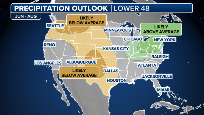
NOAA precipitation outlook for summer 2024
(NOAA)
The dry weather in the heart of North America caused historic wildfires in Canada, a scenario that could repeat itself, especially with a lack of snowfall over the winter.
The North American Seasonal Fire Assessment and Outlook warns that some fires from the record 45.7-million-acre season continue to smolder and could lead to a resurgence in 2024.
More data is expected to be released by Natural Resources Canada after it begins its seasonal forecasting on March 1, but all signs point to the possibility of more smoke-filled skies downwind of the flames.
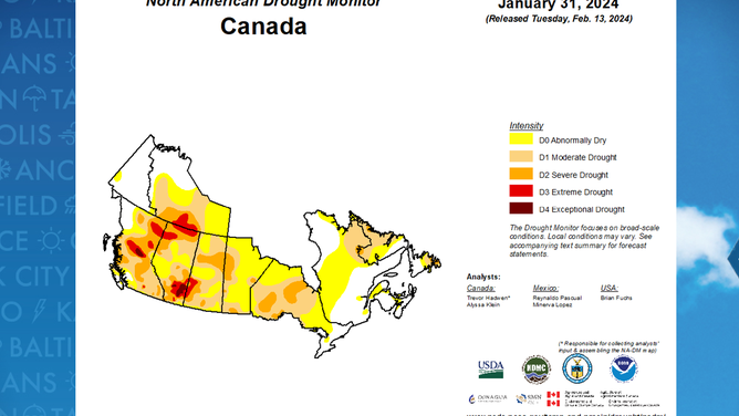
North America Drought Monitor
(FOX Weather)
Another notable nonentity from the summer outlook is a lack of any type of enhanced precipitation over the Southeast.
Usually, during active hurricane seasons, the region is highlighted for being at risk for tropical downpours, which can happen as early as June 1.
With most of the region expected to see around normal amounts of showers and thunderstorms, it indicates that NOAA forecasters believe the Southeast may not be in the target zone for much of the early tropical season development.
The months of June, July and August usually account for around 43% of all tropical cyclone activity, meaning that a slow start to the hurricane year does not indicate that the U.S. coastline will be in the clear during the heart of the season.
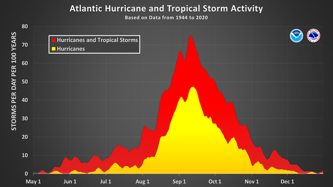
This chart shows the amount of tropical cyclone activity, in terms of named storms and hurricanes, that occurs in the Atlantic Basin on each calendar day between May 1 and Dec. 31. Specifically, it shows the number of hurricanes (yellow area) and the combined named storms and hurricanes (red area) that occur on each calendar day over a 100-year period. The chart is based on data from the 77-year period from 1944 to 2020 (starting at the beginning of the aircraft reconnaissance era) but normalized to 100 years. The official hurricane season for the Atlantic Basin is from June 1 to Nov. 30, but tropical cyclone activity sometimes occurs before and after these dates, respectively. The peak of the Atlantic hurricane season is Sept. 10, with most activity occurring between mid-August and mid-October.
(National Hurricane Center / NOAA)
NOAA’S SPRING OUTLOOK SHOWS HOW THE DYING EL NINO COULD BRING THE HEAT TO LARGE SWATH OF US
Unusual outlook for the waning El Niño
If outlooks verify, the summer maps could challenge records set in 1936 and 2021 for the warmest summers over the past 130 years.
Both seasons are tied for the warmest June-August periods in U.S. history, with an average anomaly of 2.60 °F, according to NOAA data.
Both years were not dominated by El Niños, which raises the proverbial red flag for the type of summer the U.S. faces in 2024.
During the demise of past significant El Niño events, summers have ranked as the 9th and 26th warmest in history.
A forecast of widespread, potentially record-breaking heat would make the current El Niño episode unparalleled and give more credence to climate change as playing a more prominent role in global weather than is acknowledged.
![1936 tied for warmest summer on record in U.S.]() Image 1 of 2
Image 1 of 21936 tied for warmest summer on record in U.S. ( )
![2021 tied for warmest summer on record in U.S.]() Image 2 of 2
Image 2 of 22021 tied for warmest summer on record in U.S. ( )


The extreme warmth is not unexpected as Britain’s national weather service, the Met Office, previously called for global temperatures in 2024 to finish between 1.34 °C and 1.58 °C above average.
If expectations are accurate, they would smash the annual record set just last year at around 1.18 °C above normal.
"The forecast is in-line with the ongoing global warming trend of 0.2 °C per decade, and is boosted by a significant El Niño event. Hence, we expect two new global temperature record-breaking years in succession, and, for the first time, we are forecasting a reasonable chance of a year temporarily exceeding 1.5 °C," Doctor Nick Dunstone, a climate scientist at the Met Office, previously said in a statement.