Rare ‘Super’ El Nino arrives but rapid collapse beginning as La Nina Watch issued
It's only the sixth time for an El Niño to reach at least 2.0 degrees Celsius warming since records began in 1950, but now there is a 55% chance ocean conditions will reverse to La Nina status by the summer.
El Nino forecast to quickly fade this spring and be replaced by La Nina
The current El Nino just reached 'Super' El Nino status - for only the 6th time since 1950. But forecasts now show El Nino is about to quickly fizzle out, and likely replaced by La Nina by the summer.
SILVER SPRINGS, Md. – A strong El Niño winter season has become a rare "super" El Niño season, according to the latest data issued by NOAA's Climate Prediction Center. But it's quickly losing steam as the ocean undergoes a rapid reversal, likely heading to an opposite La Niña pattern as early as this summer.
Recent sea-surface temperature measurements in the central Pacific Ocean, where El Niño is measured, climbed to 2.0 degrees Celsius (3.8 degrees Fahrenheit) above average. That pushed the event’s standing into "super El Niño" status.
It's only the sixth time for an El Niño to reach at least 2.0 degrees Celsius warming since records began in 1950 and the first since 2015-16.
The meaning of El Nino and La Nina
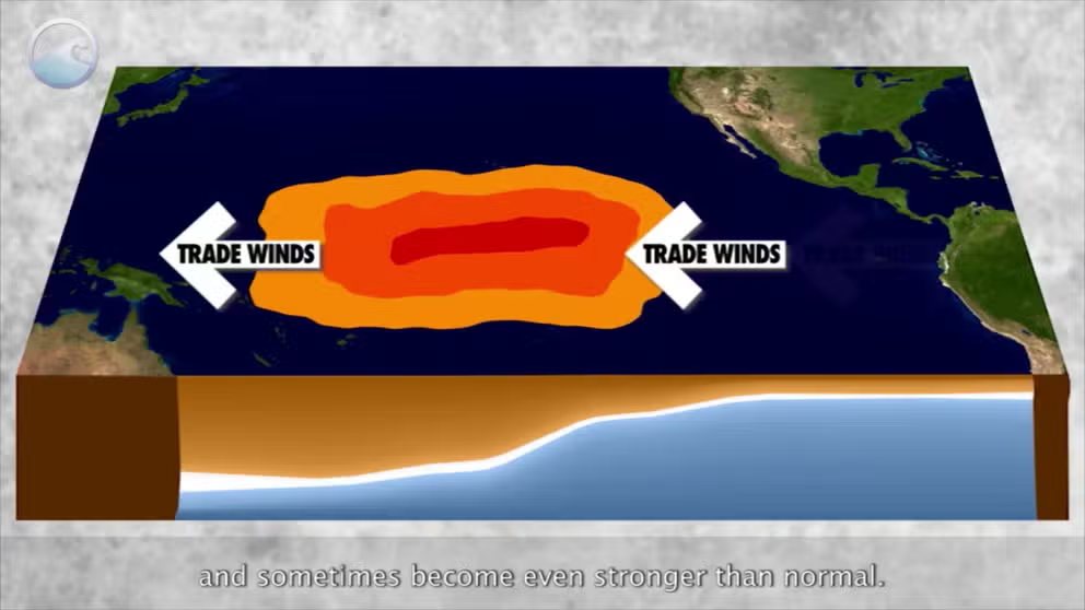
The status of whether the world is being impacted by an El Nino or a La Nina is determined by water temperatures in the central and eastern Pacific. (NOAA)
Classic El Niño events are known to produce stormy weather across the southern tier of the U.S., while the northern part of the country sees less rollercoaster-like conditions. Major events in 1982-83 and 1997-98 produced more than 150% of average precipitation in California.
This winter has been no different with California taking the brunt of several storms – many of them atmospheric river storms – leaving much of the state well above average for precipitation. With the latest series of storms to move through Southern California this week, Los Angeles received over 9 inches of rain, which is nearly two-thirds of its annual average.
WHAT ARE THE EL NIÑO AND LA NIÑA PATTERNS?
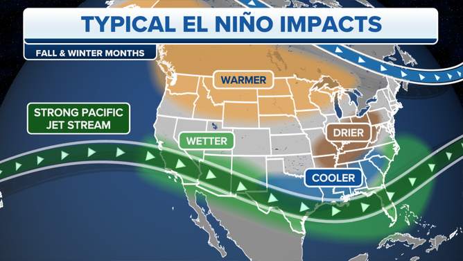
Typical El Niño impacts become more likely with a strong or historic event.
(FOX Weather)
As the strong Pacific jet stream persistently hugged the South, several rainstorms have pushed through Texas and the Gulf Coast. Florida has suffered through one of its cloudiest December-January periods on record, according to data from Alaska climatologist Brian Brettschneider.
Meanwhile, aside from a strong polar-vortex-fed arctic outbreak in mid-January, it's been a very mild winter across the nation's northern tier. Minneapolis has a scant 7 inches of seasonal snow, and people have been playing golf and installing swimming pools during the winter in a region more well known for subzero temperatures and snowstorms.
La Nina Watch issued as El Nino likely on its last legs
Despite its lofty heights, El Niño appears to have peaked and is set to come to a rapid end over the next few months. Climate prediction forecasts indicate sea-surface temperatures in the central Pacific will rapidly cool over the next several weeks, with now a 79% chance of the Pacific dropping below El Niño status in April.
Once those ocean temperatures drop below a 0.5-degree Celsius (0.9-degree Fahrenheit) anomaly, El Niño will instead be considered in a neutral phase.
NEUTRAL PHASE: WHEN EL NIÑO AND LA NIÑA ARE NO LONGER IN CONTROL
But the cooling may not stop at neutral status. Latest forecasts now indicate increasing odds that the Pacific will return to La Niña status by summer, with a 55% chance of La Niña conditions by July and a 74% chance La Niña conditions will be present by August. NOAA has issued a La Niña Watch as a result.
WHAT LA NIÑA COULD MEAN FOR SEVERE WEATHER OUTBREAKS, HURRICANE SEASON
The U.S. just came out of a rare "triple dip" La Niña in the winters of 2020-21 through 2022-23 before boomeranging into the strong El Niño this winter. The La Niña phase typically correlates to dry weather in the southern U.S. and cooler, wetter weather in the Pacific Northwest and parts of the North.
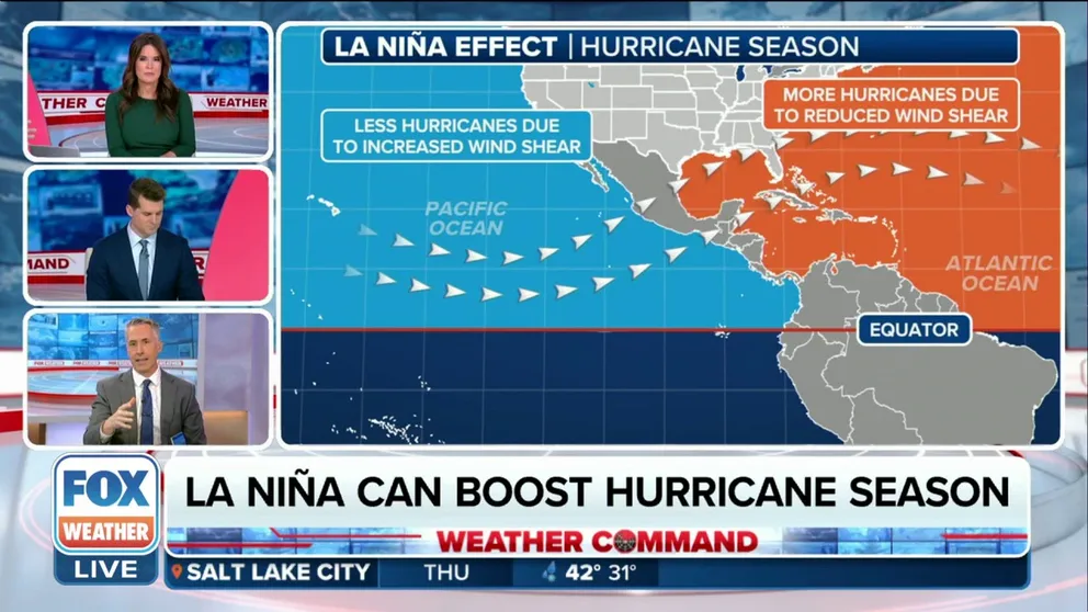
In addition, La Niña patterns tend to affect the Atlantic hurricane season.
"If the water in the box east of the International Dateline and south of Hawaii is persistently significantly below 0.5 degrees Celsius, research has shown that more hurricanes develop," FOX Weather Hurricane Specialist Bryan Norcross said. "Cold water in the Pacific Ocean tends to create upper winds across the Atlantic that are more conducive to storm development."