Paging Old Man Winter? Story behind the winter that wasn't
Meteorological winter started on Dec. 1 and ended on Feb. 29. December 2023 was the warmest Dec. on record, with an average global surface temperature that was 1.43 °C above average. All communities along the Eastern Seaboard finished with snowfall deficits. As of Feb. 15th, Syracuse, New York, was 61" of snowfall below average, and Erie, Pennsylvania, was 56" below average.
Winter comes to an end as one of warmest on record in North America
The U.S. widely experienced a warmer and less snowy winter than is typical due to a lack of cold air and a strong El Nino.
The 2023-2024 winter season finished as the warmest on record for large stretches of the U.S., resulting in temperatures that resembled fall and spring levels, which triggered a lack of wintry precipitation.
The season began on Dec. 1 and ended on Feb. 29, and much like how the season started, record heat was at the top of mind when the calendar advanced into meteorological spring.
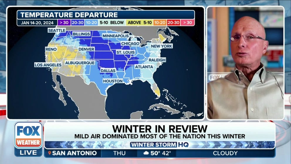
All was not lost for winter weather enthusiasts as an arctic outbreak in mid-January reminded nearly everyone of what season it was, but the chill had no staying power, a direct result of the El Niño climate pattern.
Strong El Niño events, like the one experienced over the past winter, typically lead to widespread warmth, so the outcome was not surprising to NOAA forecasters, who expected the winter to wind up on the warm side.
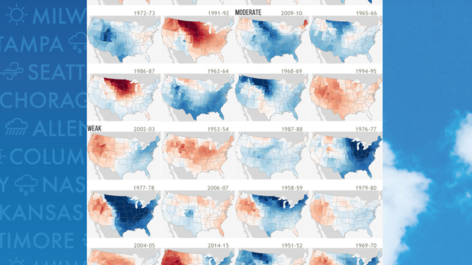
U.S. winters during El Ninos
(FOX Weather)
For many cities in California, the upper Midwest and the Northeast, temperatures were record-breaking. Fargo, North Dakota, reported a departure from normal of 14 degrees and International Falls, Minnesota, was close behind at 13 degrees above average.
WARM WINTER LEADS TO CONTINUED RECORD-LOW ICE ALONG GREAT LAKES
Warm start to winter set the tone
The average temperature during December was 40.0 °F, which was some 7.3 °F above average. NOAA said the month was the warmest in 129 years of data from previous Decembers.
This warm weather continued through the holidays and in the new year but came to a sudden halt in mid-January with a disruption of the polar vortex.
At the same time, winter storms combined with moisture and some big cities saw their first snowfall events in years.
During the arctic outbreak, more than 2,500 daily minimum temperatures county records were broken across the Lower 48.
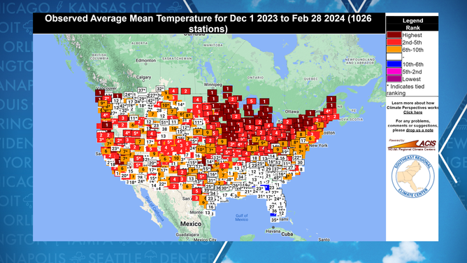
Winter 2023-24 temperature rankings
(FOX Weather)
Despite the cold air invasion, NOAA reported the first month of the year finished at 1.6 °F above average, which ranked near the middle of all years that make up the 130 years of data.
February was another month of record heat, with temperature readings in the 90s and even a 100-degree reading in Texas, while widespread 80s were reported across the lower Midwest.
Initial observations show the Lower 48 missed out on displacing the warmest February on record, which had an anomaly of 7.5 °F in 1954 but could easily make the top ten warmest.
During the three months that make up meteorological winter, cold air stayed mostly bottled up over the Arctic, and during invasions of the chilly weather, warm air from the Pacific helped to modify the air masses.
WHAT ARE EL NINO AND LA NINA CLIMATE PATTERNS?
Lack of snow
Most communities that expect to see snow during the winter across the continental U.S. wrapped up the season with deficits, but there were also notable mentions.
Major cities along the I-95 corridor broke snowless streaks that started nearly two years ago but finished well below normal.
Philadelphia ended the season more than seven inches in the red, and New York's Central Park found itself in a deficit of more than 15".

(FOX Weather)
Those deficits were more significant along the northern tier, where Syracuse, New York, saw 61" less than it should have, and Erie, Pennsylvania, reported a deficit of 56" as of mid-February.
The bright spots for snow lovers were across the Tennessee Valley and in the Mountain West, where some communities reported seasonal totals of more than 150% of what is typical.
Nashville and Boise, Idaho, were included in the few areas of the Lower 48 that saw above-average snowfall.
The lack of frozen precipitation was a direct result of warmer than typical air, as many cities reported decent rainfall events associated with the energized El Niño.
EL NINO APPEARS TO BE ON THE VERGE OF RAPID COLLAPSE
Florida: A cold spot
An unconventional location where colder-than-typical air was prevalent was in the Sunshine State, which was home to most observation sites that recorded a cooler-than-average winter.
The colder-than-typical weather was a direct result of increased rains and cloud cover that was produced by an active southern jet stream during the El Niño event.
In fact, the state reported its cloudiest period on record, which helped get evening highs lower than was typical but provided some protection from overnight cooling.
And while the weather was labeled as being cooler than average, it comes with an important asterisk- a winter day in Florida is still warmer than most of the nation.
For instance, Miami never dropped below 52 degrees, and Jacksonville, which typically sees 15 freezes, only experienced five.
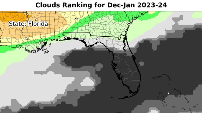
Cloud ranking for December-January using ERA5 data reanalysis from ECMWF.
(Brian Brettschneider / @Climatologist49 / FOX Weather)
RECORD-BREAKING GLOBAL HEAT SHOWS NO SIGNS OF SLOWING IN 2024
More extreme heat expected through 2024
Record-breaking heat is widely expected to dominate temperatures through the end of the year.
Britain's national weather service, the Met Office, expects the yearly average global temperature anomaly to finish between 1.34 °C and 1.58 °C above normal.
If expectations are accurate, they would smash annual records set last year at around 1.18 °C above normal.
"The forecast is in-line with the ongoing global warming trend of 0.2 °C per decade, and is boosted by a significant El Niño event. Hence, we expect two new global temperature record-breaking years in succession, and, for the first time, we are forecasting a reasonable chance of a year temporarily exceeding 1.5 °C," Doctor Nick Dunstone, a climate scientist at the Met Office, previously said in a statement.
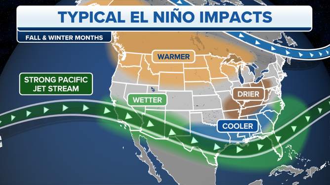
Typical El Nino impacts become more likely with a strong or historic event.
(FOX Weather)
Even though the global weather pattern known as El Niño is waning, there is a lag between what is experienced in the short-term and when conditions will reflect the new patterns that are in charge.
A lag is relatively common as it takes longer for water to gain and lose warmth than it does for air.
Take the summer solstice, for example; even though it occurs every June in the Northern Hemisphere when the Sun's rays are most direct, oceans and land usually don't peak in temperature until July or August.
According to NOAA, January clocked in at an astonishing 1.27 °C above average globally, ranking it as the warmest start to any year in 175 years of record keeping.
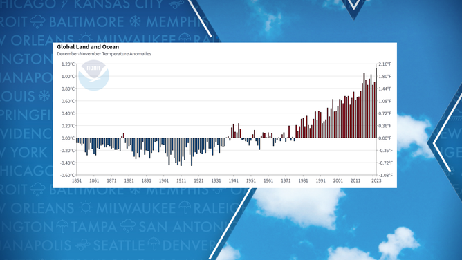
Global land and sea temperature anomalies
(NOAA)