Future Imelda prompts Tropical Storm Watch in Florida as system creeps closer to Southeast US coast
Tropical storm alerts have now been posted along the eastern Florida coast as a storm system near the Bahamas has been designated Tropical Depression Nine, on its way to becoming Hurricane Imelda, bringing the potential threat of days of flooding rain and strong winds to parts of the Southeast.
Bryan Norcross: Big change to future Imelda’s forecast track lowers risk of significant US impacts
Tropical Depression Nine is likely to strengthen into Tropical Storm Imelda on Sunday, and as FOX Weather Hurricane Specialist Bryan Norcross explains, chances for significant impacts along the southeastern U.S. coast from Florida to the Carolinas are starting to dwindle.
Tropical Depression Nine intensified into Tropical Storm Imelda near the central and northwestern Bahamas on Sunday afternoon. Click here to follow the latest updates on Imelda.
MIAMI – Tropical storm alerts remain in effect for portions of the eastern Florida coastline, and at least two states have declared preemptive states of emergency as a looming storm system remains on its way to becoming Hurricane Imelda, bringing the potential threat of days of flooding rain and strong winds to parts of the Southeast coast.
The National Hurricane Center (NHC) designated the system Tropical Depression Nine after winds reached 35 mph and developed a tropical core.
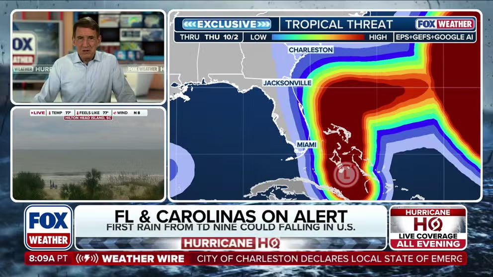
And with the storm system expected to continue to develop and strengthen, a Tropical Storm Watch now extends from the Palm Beach/Martin County line northward to the Flagler/Volusia County line.
LIVE FUTURE-IMELDA TRACKER: SPAGHETTI PLOTS, FORECAST CONES FOR TD 9 AS STORM MAY SOON BECOME IMELDA

(FOX Weather)
While Florida isn’t expecting a landfall from future Hurricane Imelda, the storm is expected to move close enough that it could bring tropical-storm-force winds on Monday.
Next comes solving the complicated future of Tropical Depression Nine, which still features multiple scenarios over the next several days.
Tropical Depression Nine is currently located in the area of eastern Cuba and the southeastern Bahamas and is moving off to the north.

Life-threatening rip currents, large waves expected along Florida coast due to future Imelda
What will likely become Hurricane Imelda isn't expected to make landfall in Florida, but large waves and life-threatening rip currents are expected along the coast. FOX Weather Meteorologist Michael Estime has the latest from Melbourne on Sept. 28, 2025.
The NHC said that a faster motion to the north-northwest or north is expected later Sunday, and that should continue through Monday.
On that forecast track, the center of Tropical Depression Nine is expected to move across the central and northwestern Bahamas later Sunday and Sunday night, and then turn east-northeastward, moving away from the southeastern U.S. by the middle of this week.

(FOX Weather)
A Tropical Storm Warning remains in effect for the central Bahamas, including Cat Island, the Exumas, Long Island, Rum Cay and Sal Salvador. Portions of the northwestern Bahamas are also included in the Tropical Storm Warning.
But while there remains tremendous uncertainty in the storm's eventual track as it continues to move north early this week due to a myriad of complex atmospheric variables in play – including the storm's proximity to major Hurricane Humberto – multiple forecast models suggest the storm could still track close enough to the Southeast coast to bring significant impacts from Florida to North Carolina.
The NHC's official forecast cone predicts future Imelda will reach hurricane status just off the east coast of Florida by Monday night or Tuesday and remain a hurricane throughout the week as it crawls northward just off the southeastern U.S. coast, then takes a sharp turn to the east and tracks in the direction of Bermuda.
BEWARE OF THE 'I' STORM: IT HAS MORE RETIREES THAN ANY LETTER USED FOR ATLANTIC HURRICANE NAMES

(FOX Weather)
"Even if likely-Hurricane Imelda does not make landfall, potentially dangerous rainfall is likely over at least South Carolina and the eastern two-thirds of North Carolina, with the Lowcountry and southeastern North Carolina getting the most," FOX Weather Hurricane Specialist Bryan Norcross said.
The NHC said storm rainfall totals of 2-4 inches, with locally higher amounts of up to 7 inches, are expected through Wednesday morning across portions of the coastal Carolinas. That rainfall could result in flash, urban and isolated, minor river flooding.
However, the NHC said changes to the forecast track would also change the forecast rainfall totals.
Minor coastal flooding is also possible in areas with onshore winds over the southeastern U.S. Forecasters said areas from the Volusia/Brevard County line in Florida to the South Santee River in South Carolina could see a 1- to 2-foot storm surge.
The NHC indeed says the system is expected to be at or near hurricane intensity early this week when it approaches the southeastern U.S. coast, where there is a risk of storm surge and wind impacts.
"I think the thing we're most concerned about is it's not going to (need) a direct landfall for there to be some significant impacts from storm surge, winds, rainfall, flooding, especially if we have a system that's meandering here along or near the coast, say, of South Carolina," National Hurricane Deputy Director Michael Brennan told FOX Weather. "And there are still scenarios where the system could come in and make landfall or sit here for several days or stall out and then move off to the east. So, but again, it's just to remind people that even if you don't see an explicit landfall forecast, it doesn't mean there aren't going to be impacts."
The worrisome forecast has prompted South Carolina Gov. Henry McMaster to declare a preemptive state of emergency for the entire state.
ATLANTIC HURRICANE SEASON PULLS OFF FEAT NOT SEEN IN 90 YEARS
States prepare for potential impacts
Aside from the state of emergency in South Carolina, cities and counties were taking localized precautions.
The City of Charleston announced a local state of emergency Saturday, clearing storm drains, lowering water levels, prepositioning water pumps and bringing in extra staff.
"Today’s action is about readiness," Mayor William Cogswell said. "We’ll keep residents informed with clear, timely updates as the forecast evolves."
Conway, South Carolina, declared a local state of emergency ahead of the storm, and Folly Beach closed its City Hall on Friday.

(FOX Weather)
North Carolina's Emergency Management department said it is also monitoring the latest weather forecasts.
Duke Energy, which services power to 80 counties in North Carolina, said a significant portion of the storm's possible path is in its service area.
"Our in-house team of meteorologists is following the path of that storm, and we use that forecast to power our damage modeling system," spokesperson Jeff Brooks told FOX Weather. "And that modeling system helps us to identify where we’re likely to see storm impacts. Our goal is always, if we can, to position resources at the appropriate places so they’re able to respond quickly when the storm strikes."