Beware of the 'I' storm: It has more retirees than any letter used for Atlantic hurricane names
Hurricane Ian in 2022 was the latest chapter in a notorious stretch for "I" storms in the Atlantic. Since the retirement practice began, 13 "I" storms have been retired in the Atlantic – 11 of them since 2001.

Why do some hurricane names become retired
Hurricane Specialist Bryan Norcross has got you covered to answer your questions as the FOX Weather Q&A is LIVE.
Hurricane Ian in 2022 became the latest "I" name retired from the hurricane naming lists by the World Meteorological Organization. Ian is one of 13 retirees starting with a letter that may strike fear in those living along the East and Gulf coasts.
Hurricane Ian rapidly intensified into a major hurricane before making a catastrophic Category 4 landfall in Southwest Florida on Sept. 28, 2022. Ian caused extensive damage across the Sunshine State before going on to impact other parts of the Southeast in the days that followed.
Nearly 150 people died due to the storm. Ian ranks as the third-costliest hurricane in U.S. history, causing an estimated $119.6 billion of damage, according to NOAA.
IAN, FIONA RETIRED FROM HURRICANE NAMING LISTS BY WORLD METEOROLOGICAL ORGANIZATION
Prior to Ian, one only had to go back a year to find another "I"-named storm that hit portions of the mainland U.S.
Due to the nature of the alphabet, storms such as Ian, Ida and Irma have typically formed when atmospheric conditions are at their prime and water temperatures are at their warmest during what is the peak of the Atlantic hurricane season.
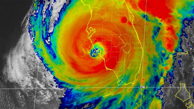
Hurricane Ian is seen in this satellite image taken as the storm made landfall in Southwest Florida on Sept. 28, 2022.
(NOAA)
Hurricane Ida retired after 2021 season
Hurricane Ida crashed ashore in southeastern Louisiana on Aug. 29, 2021, with maximum sustained winds of about 150 mph, a Category 4 on the Saffir-Simpson Hurricane Wind Scale.
The storm produced a powerful 14-foot storm surge along the Louisiana coastline and dumped torrential rainfall across much of the northern Gulf Coast, but its impacts didn't stop there. The storm's effects were also felt up the entire Eastern Seaboard, where tornadoes and flooding were reported as north as New England.
Hurricane Ida was blamed for the deaths of more than 100 people, and its estimated damages topped $84 billion from the Caribbean to New England. The destruction was enough to propel the storm to the sixth-costliest hurricane in U.S. history, ranking just behind Katrina, Harvey, Ian, Maria and Sandy, respectively.
The World Meteorological Organization voted in April 2022 to retire the name "Ida" from future use in the Atlantic Basin.
IDA RETIRED FROM TROPICAL CYCLONE NAMING LIST AFTER BECOMING 6TH COSTLIEST U.S. HURRICANE
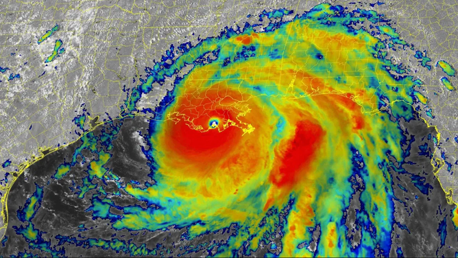
Infrared satellite image of Hurricane Ida after the storm made landfall in southeastern Louisiana on Sunday, Aug. 29, 2021.
(NOAA/NESDIS/STAR)
Why storm names are retired
A storm's name can be retired if its impacts were particularly destructive and/or deadly. This would avoid the use of Ian, for example, for a future Atlantic "I" storm that might not even become a hurricane or affect any land areas.
Interestingly, more storms starting with "I" have been retired than a name beginning with any other letter. Since this retirement practice began in 1954, 13 "I" storms have been retired by the WMO. Second place is "F" storms, with 10 retirees – Fiona being the most recent after the 2022 season. Eleven of the 13 retired "I" storms have occurred since 2001.
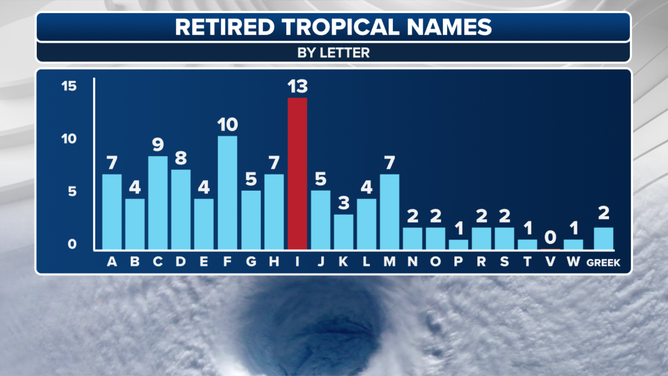
Retired tropical cyclone names by letter.
(FOX Weather)
The WMO voted to replace the name "Ian" on the 2028 list of Atlantic tropical cyclone names with "Idris." That's when the 2022 list will be used again since the names run on a six-year rotation.
The most recent hurricanes to have their names retired were Beryl, Helene and Milton after their historic impacts in 2024.
THE BEASTS OF THE ATLANTIC: 99 HURRICANE OR TROPICAL STORM NAMES HAVE BEEN RETIRED
An average Atlantic hurricane season spawns 14 named storms, according to NOAA's most recent 30-year period of record (1991-2020). The "I" storm is the ninth of the season, so that means we can expect an "I" essentially every year.
Satellites began monitoring the entire Atlantic Basin in 1966, and 38 of the 58 hurricane seasons since then have reached the "I" storm, including Ian in 2022, Idalia in 2023 and Isaac in 2024. Based on data from NOAA and the National Hurricane Center, around mid-September was the average point in the season when the "I" storm formed in those 38 seasons. The earliest was June 28 (2020) and the latest was Oct. 13 (1999).
HERE'S WHY THE ATLANTIC HURRICANE SEASON RUNS FROM JUNE TO NOVEMBER
The mid-September period, when the "I" storm typically forms, is the peak of hurricane season. This is when environmental conditions tend to be most favorable for tropical cyclone development: water temperatures are at their highest across the Atlantic Ocean, the Caribbean Sea and the Gulf; wind shear – the change in wind speed and direction with height that can rip apart developing tropical cyclones – is usually low; and tropical waves emerging off western Africa are often very robust.
When all of those conditions come into alignment, it's a "recipe" for strong hurricanes to develop and track hundreds of miles across the Atlantic Basin.
The "I" storm just typically happens to come during this "recipe for disaster."