Ian, Fiona retired from hurricane naming lists by World Meteorological Organization
As of March 2023, 96 storm names have been retired. The names Ian and Fiona will never be used again on any of the six alphabetic lists that rotate each year.
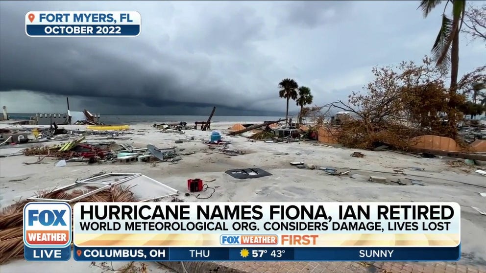
Hurricane names Fiona and Ian have been retired
The World Meteorological Organization has retired the names "Ian" and "Fiona" from the list of hurricane names.
A hurricane named Ian or Fiona will never threaten land again after the World Meteorological Organization removed the names from a rotating list due to the damage and lives lost during the 2022 tropical season.
Hurricane Fiona developed in the Caribbean in mid-September and peaked in organization in the western Atlantic. The hurricane topped out at Category 4 strength and caused at least $6 billion in damage.
Not long after Fiona, Hurricane Ian developed during the same month and produced severe damage in both Cuba and Florida. The Category 4 storm was the deadliest hurricane in more than 80 years in the Sunshine State and caused more than $100 billion in damage.
With the addition of Fiona and Ian, 96 storm names have been retired from six alphabetic lists that rotate each year. The names will be replaced with Farrah and Idris when the list is recycled in 2028, according to the WMO.
No other letter has had more replacements than "I"-named storms. Thirteen have been retired in the Atlantic basin, with ten occurring just in the past two decades alone.
BEWARE OF THE ‘I’ STORM: IT HAS MORE RETIREES THAN ANY LETTER USED FOR ATLANTIC HURRICANE NAMES
Due to the nature of the alphabet, the ninth named usually forms around September 16th, when water temperatures are at the warmest and atmospheric conditions are conducive for extensive development.
These factors allow for intense hurricanes to form, with many reaching Category 3, 4 or 5 status on the Saffir-Simpson Hurricane Wind Scale.
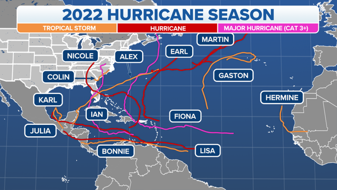
2022 Hurricane Season Tracks
(FOX Weather)
Hurricane Fiona retired – (September 14 – 23, 2022)
Fiona was the first major hurricane of the 2022 tropical cyclone season and the most intense system on record ever to impact maritime Canada.
The cyclone became a tropical storm on September 15, impacting the Lesser Antilles before heading toward Puerto Rico and the Dominican Republic.
The tropical storm strengthened into a hurricane before impacting what are known as the Greater Antilles.
The combination of rain and wind on a weakened power grid in the U.S. territory of Puerto Rico led to island-wide blackouts.
After exiting the Caribbean and entering the southwest Atlantic, an aircraft with 53rd Weather Reconnaissance Squadron determined that the hurricane strengthened into a Category 4 with maximum sustained winds of 140 mph and a pressure of 931 millibars.
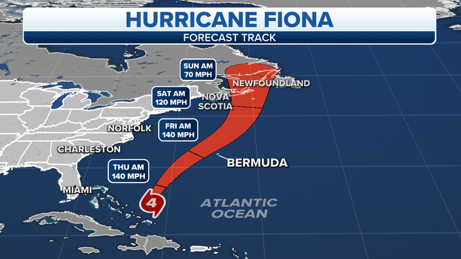
The cone of uncertainty for Hurricane Fiona, a powerful Category 4 hurricane as of September 21, 2022.
(FOX Weather)
Fortunately, the hurricane weakened some before sideswiping Bermuda and impacting Nova Scotia and Newfoundland.
Fiona was officially an extratropical cyclone when it made landfall in southeast Canada on September 24.
A post-storm report concluded Fiona led to the deaths of 29 people from the Caribbean to Canada, and damage was estimated at more than $6 billion.
Due to the storm remaining hundreds of miles of the U.S. East Coast, there were only minimal impacts to the lower 48, which included increased rip currents and higher-than-average seas.
As Fiona was winding down over Canada, a new tropical threat was just getting started in the Caribbean Sea.
DRONE VIDEO SHOWS 50-FOOT WAVES AND DESTRUCTIVE WINDS IN THE HEART OF HURRICANE FIONA

Ocean drone captures wrath of Hurricane Fiona
Vice President of Product at Saildrone Kim Sparling tells FOX Weather the mission is to sail robots on the surface of the ocean and collect data which is shared with partners such as the NOAA. A saildrone was able to capture 50 feet waves and 100 mph winds in the Atlantic Ocean on Thursday.
Hurricane Ian retired – (September 23–30, 2022)
Ian will be remembered for being the costliest disaster in all of 2022 and for being the deadliest storm to strike Florida in more than 80 years.
The storm system began as a tropical wave off Africa but really didn’t get its act together until the central Caribbean, where it became a tropical storm on September 24.
Ian rapidly strengthened into a Category 3 hurricane before striking Cuba, knocking out power to millions and causing five deaths.
The hurricane exited the island nation into the Gulf of Mexico and rapidly strengthened into a Category 4 storm with winds sustained around 155 mph and a pressure that reached 936 millibars.
The hurricane's first U.S. landfall occurred on Cayo Costa Island, Florida, very near where Hurricane Charley made landfall almost 20 years ago.
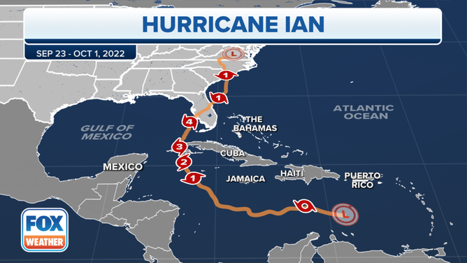
The track of Hurricane Ian.
(FOX Weather)
The hurricane produced a devastating storm surge for communities in the Fort Myers area, and impacts from wind, rain and tornadoes were reported in a large part of the Florida Peninsula.
After impacting the Sunshine State, the storm system continued north and eastward, bringing damaging wind gusts to the Carolinas, mid-Atlantic and Northeast.
After the damage, estimates put the impact at more $100 billion and more than 150 deaths were attributed to the storm.
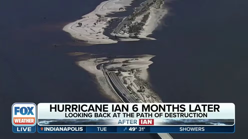
Looking back at the path of destruction from Hurricane Ian 6 months later
FOX Weather's Mitti Hicks recounts the unfolding of Hurricane Ian six months after the storm ripped through Southwest Florida.
6 MONTHS AFTER IAN: RECOVERING FLORIDA COMMUNITIES PREPARE FOR START OF ANOTHER HURRICANE SEASON
Looking ahead to the 2023 hurricane season
It is too early to tell how tropical cyclone activity and the incoming El Niño will interact, but usually during these weather patterns, there are fewer systems to track than during an average year in the Atlantic basin.
An average season in the Atlantic Ocean, Gulf of Mexico and the Caribbean Sea produces 14 named storms, of which seven go on to become hurricanes, and three typically reach major hurricane status with winds of at least 115 mph.
The FOX Forecast Center warns if the onslaught of El Niño is faster than anticipated, then hostile conditions across the basin could be at play earlier in the season and lead to reduced tropical cyclone development. If the start of less-than-prime conditions is delayed until after the heart of the season, such as in late October or November, it could give potential cyclones a decent four or five months largely without the interference of El Niño.
The first tropical season forecast is expected to be released by experts at Colorado State University in April, with NOAA releasing its forecast in May.
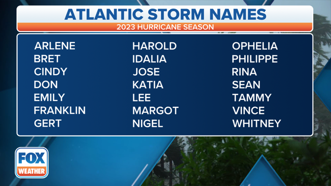
Here is the list of names for the 2023 Atlantic Hurricane Season.
(FOX Weather)