Norma dissipates over Mexico after making 2nd landfall Monday
Norma made landfall along Mexico’s Baja California coast as a Category 1 hurricane late Saturday night, bringing large waves, flooding and high winds to a region that includes Cabo San Lucas. The storm has since dissipated after making a second landfall on Monday morning.
Tropical Storm Otis on collision course with southern Mexico
Tropical Storm Watches are in effect in southern Mexico as Tropical Storm Otis makes its way closer to the coast.
Tropical Storm Watches have been issued in southern Mexico after Tropical Storm Otis formed Sunday on the heels of former Hurricane Norma, continuing an active tropical stretch for the Eastern Pacific.
Norma made landfall along Mexico’s Baja California coast as a Category 1 hurricane late Saturday night, bringing large waves, flooding and high winds to a region that includes Cabo San Lucas.
Norma has since weakened and dissipated after making a second landfall along the west coast of mainland Mexico on Monday morning.
CAN TROPICAL CYCLONES MAKE IT ACROSS THE ENTIRE PACIFIC OCEAN?
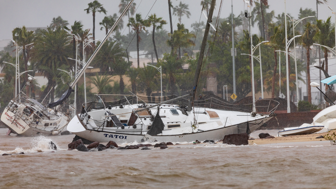
![LA PAZ, MEXICO - OCTOBER 21: Sailboats stranded on the beach due to strong waves and wind on October 21, 2023 in La Paz, Mexico. Norma made landfall as a category 2 storm in the area of Los Cabos in Mexican state of Baja California Sur causing big waves and heavy rains also in Sinaloa, Nayarit and Jalisco. (Photo by Alfredo Martinez/Getty Images)]() Image 1 of 13
Image 1 of 13LA PAZ, MEXICO - OCTOBER 21: Sailboats stranded on the beach due to strong waves and wind on October 21, 2023 in La Paz, Mexico. Norma made landfall as a category 2 storm in the area of Los Cabos in Mexican state of Baja California Sur causing big waves and heavy rains also in Sinaloa, Nayarit and Jalisco. (Photo by Alfredo Martinez/Getty Images) ( )
![LA PAZ, MEXICO - OCTOBER 21: A sailboat runs aground on the beach on October 21, 2023 in La Paz, Mexico. Norma made landfall as a category 2 storm in the area of Los Cabos in Mexican state of Baja California Sur causing big waves and heavy rains also in Sinaloa, Nayarit and Jalisco. (Photo by Alfredo Martinez/Getty Images)]() Image 2 of 13
Image 2 of 13LA PAZ, MEXICO - OCTOBER 21: A sailboat runs aground on the beach on October 21, 2023 in La Paz, Mexico. Norma made landfall as a category 2 storm in the area of Los Cabos in Mexican state of Baja California Sur causing big waves and heavy rains also in Sinaloa, Nayarit and Jalisco. (Photo by Alfredo Martinez/Getty Images) ( )
![A restaurant remains closed before the arrival of hurricane Norma in Los Cabos, Baja Californa state, Mexico on October 21, 2023. Hurricane Norma is expected to slam into Mexico's northwestern coast within hours, bringing "life-threatening" winds, flooding, and a dangerous sea surge, authorities warned Saturday. The storm, still powerful though downgraded overnight from Category 3 to Category 2 on the Saffir-Simpson scale, was headed toward a part of Mexico's Baja California coast popular with tourists. (Photo by Joel Cosio / AFP) (Photo by JOEL COSIO/AFP via Getty Images)]() Image 3 of 13
Image 3 of 13A restaurant remains closed before the arrival of hurricane Norma in Los Cabos, Baja Californa state, Mexico on October 21, 2023. Hurricane Norma is expected to slam into Mexico's northwestern coast within hours, bringing "life-threatening" winds, flooding, and a dangerous sea surge, authorities warned Saturday. The storm, still powerful though downgraded overnight from Category 3 to Category 2 on the Saffir-Simpson scale, was headed toward a part of Mexico's Baja California coast popular with tourists. (Photo by Joel Cosio / AFP) (Photo by JOEL COSIO/AFP via Getty Images) ( )
![LA PAZ, MEXICO - OCTOBER 21: Strong waves crash against the sea wall on October 21, 2023 in La Paz, Mexico. Norma made landfall as a category 2 storm in the area of Los Cabos in Mexican state of Baja California Sur causing big waves and heavy rains also in Sinaloa, Nayarit and Jalisco. (Photo by Alfredo Martinez/Getty Images)]() Image 4 of 13
Image 4 of 13LA PAZ, MEXICO - OCTOBER 21: Strong waves crash against the sea wall on October 21, 2023 in La Paz, Mexico. Norma made landfall as a category 2 storm in the area of Los Cabos in Mexican state of Baja California Sur causing big waves and heavy rains also in Sinaloa, Nayarit and Jalisco. (Photo by Alfredo Martinez/Getty Images) ( )
![A man watches the water level rise during a severe storm and flooding as Hurricane Norma beings to make landfall on October 21, 2023 in La Paz, Mexico. According to NOAA, Norma is expected to bring life-threatening hurricane conditions and a dangerous storm surge to portions of the southern Baja California peninsula.]() Image 5 of 13
Image 5 of 13A man watches the water level rise during a severe storm and flooding as Hurricane Norma beings to make landfall on October 21, 2023 in La Paz, Mexico. According to NOAA, Norma is expected to bring life-threatening hurricane conditions and a dangerous storm surge to portions of the southern Baja California peninsula. (Alfredo Martinez)
![A pharmacy worker protects the shop from the arrival of Hurricane Norma at Los Cabos in Baja California State, Mexico, on October 20, 2023. Hurricane Norma on Friday once again strengthened to a Category 3 storm as it approaches a tourist hotspot on Mexico's Pacific coast. The hurricane -- which at one point was a Category 4 out of five on the Saffir-Simpson scale -- is now packing maximum sustained winds of 195 kilometers per hour (120 miles per hour), the US National Hurricane Center said in its latest update. It had been a Category 2 storm earlier in the day.]() Image 6 of 13
Image 6 of 13A pharmacy worker protects the shop from the arrival of Hurricane Norma at Los Cabos in Baja California State, Mexico, on October 20, 2023. Hurricane Norma on Friday once again strengthened to a Category 3 storm as it approaches a tourist hotspot on Mexico's Pacific coast. The hurricane -- which at one point was a Category 4 out of five on the Saffir-Simpson scale -- is now packing maximum sustained winds of 195 kilometers per hour (120 miles per hour), the US National Hurricane Center said in its latest update. It had been a Category 2 storm earlier in the day. (Joel Cosio/AFP)
![MEXICO-WEATHER-HURRICANE-NORMA]() Image 7 of 13
Image 7 of 13A restaurant remains closed due to the arrival of Hurricane Norma at Los Cabos in Baja California State, Mexico, on October 20, 2023. Hurricane Norma on Friday once again strengthened to a Category 3 storm as it approaches a tourist hotspot on Mexico's Pacific coast. The hurricane -- which at one point was a Category 4 out of five on the Saffir-Simpson scale -- is now packing maximum sustained winds of 195 kilometers per hour (120 miles per hour), the US National Hurricane Center said in its latest update. It had been a Category 2 storm earlier in the day. (JOEL COSIO/AFP)
![MEXICO-WEATHER-HURRICANE-NORMA]() Image 8 of 13
Image 8 of 13A restaurant remains closed due to the arrival of Hurricane Norma at Los Cabos in Baja California State, Mexico, on October 20, 2023. Hurricane Norma on Friday once again strengthened to a Category 3 storm as it approaches a tourist hotspot on Mexico's Pacific coast. The hurricane -- which at one point was a Category 4 out of five on the Saffir-Simpson scale -- is now packing maximum sustained winds of 195 kilometers per hour (120 miles per hour), the US National Hurricane Center said in its latest update. It had been a Category 2 storm earlier in the day. (JOEL COSIO/AFP)
![Hurricane Norma Damage]() Image 9 of 13
Image 9 of 13Crews clean up damage from Hurricane Norma in Las Guacamayas. (Gobierno de Lázaro Cárdenas)
![Hurricane Norma Damage]() Image 10 of 13
Image 10 of 13Crews clean up damage from Hurricane Norma in Las Guacamayas (Gobierno de Lázaro Cárdenas)
![Hurricane Norma Damage]() Image 11 of 13
Image 11 of 13Crews clean up damage from Hurricane Norma in Las Guacamayas (Gobierno de Lázaro Cárdenas)
![Hurricane Norma Damage]() Image 12 of 13
Image 12 of 13Crews clean up damage from Hurricane Norma in Las Guacamayas (Gobierno de Lázaro Cárdenas)
![Hurricane Norma landfall in Mexico]() Image 13 of 13
Image 13 of 13Hurricane Norma makes landfall in Mexico ( )


Once a Category 4 hurricane, Norma weakened significantly before it made landfall south of Cabo San Lucas, which helped spare some communities surrounding the popular tourist destination from more extensive damage.
Flooding from rainfall was reported around the Baja California Peninsula, with at least 4 inches of rain falling over the past few days.
An elevated weather station in the hills overlooking Cabo San Lucas reported multiple wind gusts of more than 90 mph, with a peak gust of 107 mph.
Several retail centers near the coast were closed due to the hazardous weather.
The National Hurricane Center (NHC) says rainfall from Norma will diminish across northern portions of Sinaloa, northern Durango and southern Chihuahua later Monday. Additional isolated rainfall totals of 1 to 2 inches are possible, along with isolated flash flood and mudslide risks in the higher terrain.
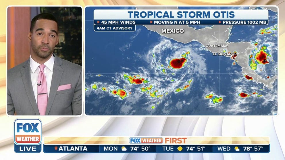
Tropical Storm Otis forms off Central America

(FOX Weather)
Tropical Storm Otis is centered about 400 miles south-southeast of Acapulco, Mexico, and is moving to the north at 5 mph.
Otis has maximum sustained winds of 45 mph with some higher gusts. Some strengthening is expected over the next few days, but Otis is expected to remain below hurricane strength.

(FOX Weather)
The NHC says Otis will continue on a north-northwest or northward motion for the next few days. On that forecast track, the center of Otis will approach the southern coast of Mexico from late Tuesday into Wednesday.
Because of the threat of tropical-storm-force winds (39-plus mph), the government of Mexico has issued a Tropical Storm Watch from Lagunas de Cachahua to Tecpan de Galeana.
A Tropical Storm Watch means winds between 39 and 73 mph are possible in the watch area within 48 hours.
Large waves, high winds lash Mexico
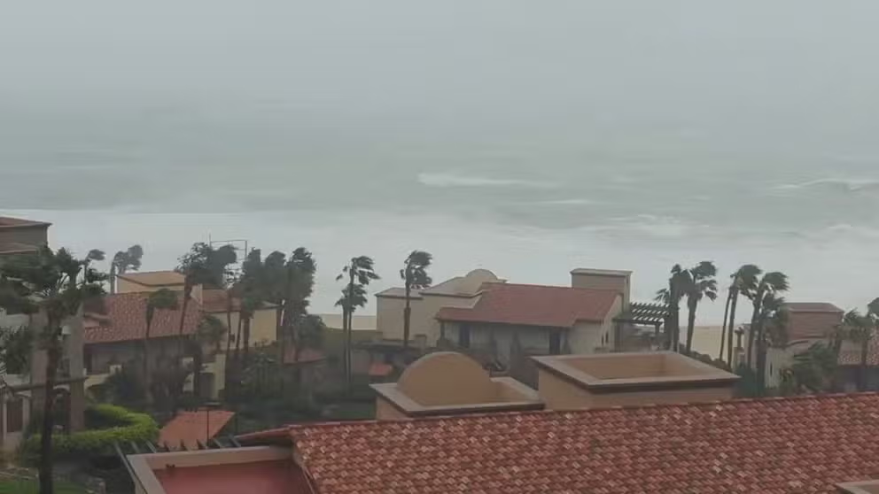
Watch: Surf pounds Cabo San Lucas as Hurricane Norma nears landfall
Video from Cabo San Lucas, Mexico, shows large wave and strong winds lashing the coast as then Hurricane Norma was nearing landfall on Saturday.
Videos from the region as Norma neared landfall on Saturday showed heavy rain and high winds lashing coastal communities, with palm trees bending during the stronger gusts. In addition to the rain and wind, large waves battered the coast.

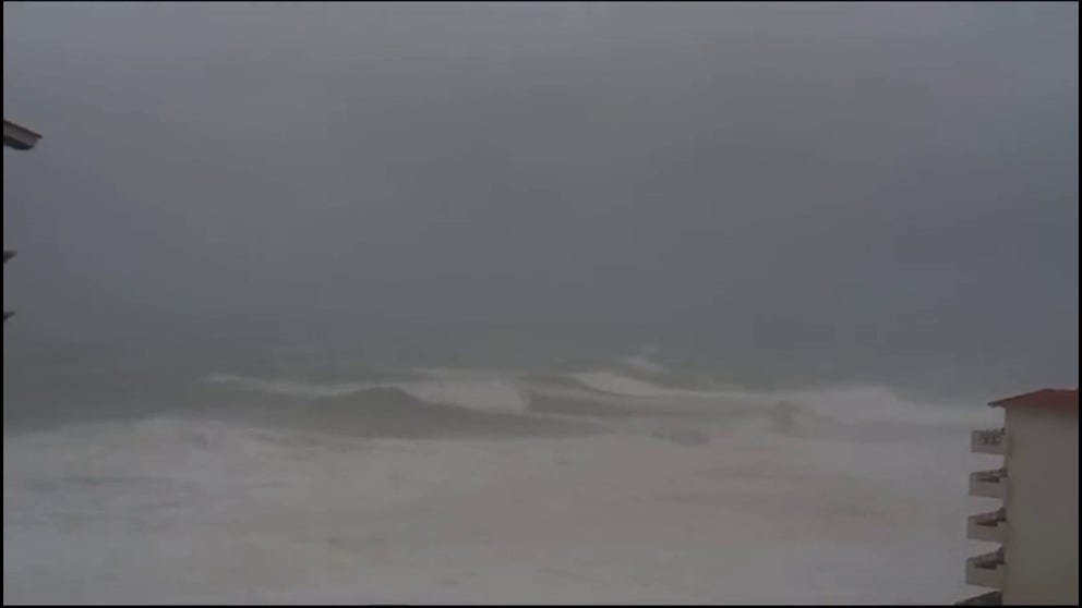
Watch: Heavy rain, strong winds lash Cabo San Lucas during Hurricane Norma
Video from Cabo San Lucas, Mexico, shows heavy rain and strong winds lashing the region as then Hurricane Norma was making landfall on Saturday.
The heavy rainfall triggered local authorities to move pumps to low-lying areas to help protect infrastructure and minimize road closures.
The government encouraged those in Norma's path to stay sheltered while the worst of the impacts moved through.
Hurricane Norma produced large waves along the coastline of the southern Baja California Peninsula
Mexican authorities encouraged visitors and residents to stay away from coastal communities where the worst of the weather was anticipated to impact over the weekend.
Norma's remnants to soak southern Plains
Norma fall apart Monday after pushing ashore in the mountainous terrain of Sinaloa, but its deep surge of moisture will live on. It will push into the Desert Southwest early this week and give the southern Plains a one-two dose of tropical moisture.

(FOX Weather)
Rainfall began Monday in Texas and will begin spreading northward by Tuesday.
REMNANTS OF HURRICANE NORMA WILL HELP BRING DROUGHT RELIEF TO TEXAS, OKLAHOMA
Atlantic Invest 95L could wander into the Pacific
Computer forecast models suggest Invest 95L in the southwestern Caribbean Sea will slide westward across Central America and southern Mexico. The disturbance has a medium chance of developing into a short-lived tropical depression.
Regardless of development, this system could produce heavy rain over portions of Central America over the next couple of days.

(FOX Weather)