Tornado causes damage near San Antonio following high-water rescues in Dallas
An NWS storm survey team later confirmed Friday an EF-0 tornado touched down through Fort Sam Houston Thursday morning, lasting about 17 minutes as it swirled on the ground for just over 5 miles. The twister's peak wind speed was estimated at 80 mph.
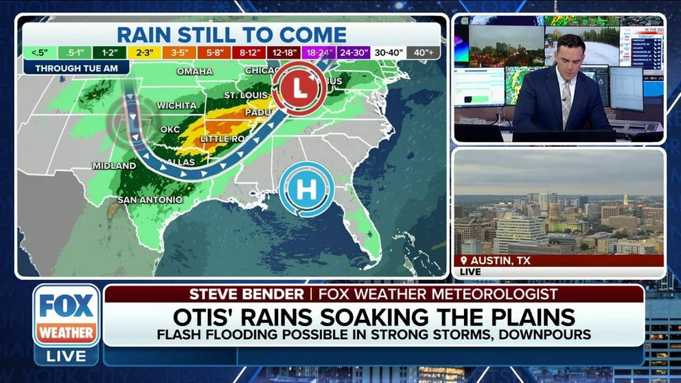
Texas, Southern Plains soaked by remnants of Hurricane Otis
Parts of Texas received more than 9 inches of rain in the past 48 hours, leading to flash flooding. As the downpours move eastward, flash flooding is possible for parts of East Texas, Oklahoma, Arkansas and Missouri into the weekend. Oct. 26, 2023.
SAN ANTONIO – A combination of favorable upper-level winds, Gulf of Mexico tropical moisture and moisture from the remnants of Hurricane Otis streaming northward created showers and thunderstorms with heavy rain over the southern Plains again on Thursday, triggering at least one tornado in Texas.
![]() Image 1 of 13
Image 1 of 13Tornado spotted in the San Antonio area. Oct. 26, 2023. (@brenduh_L / X)
![Debris flies through the air during a tornado in San Antonio, Texas, on Oct. 26, 2023.]() Image 2 of 13
Image 2 of 13Debris flies through the air during a tornado in San Antonio, Texas, on Oct. 26, 2023. (KABB)
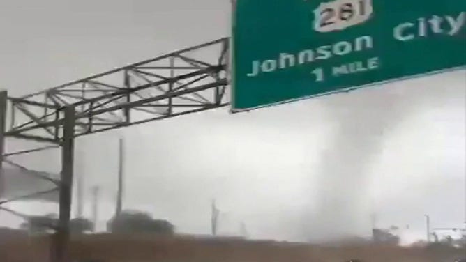
![Drivers spotted what appears to be a tornado as it crossed a highway in San Antonio, Texas, on Oct. 26, 2023.]() Image 3 of 13
Image 3 of 13Drivers spotted what appears to be a tornado as it crossed a highway in San Antonio, Texas, on Oct. 26, 2023. (KABB-TV)
![Aftermath of tornado at JBSA Fort Sam Houston. Oct. 26, 2023.]() Image 4 of 13
Image 4 of 13Aftermath of tornado at JBSA Fort Sam Houston. Oct. 26, 2023. (DVIDS)
![Aftermath of tornado at JBSA Fort Sam Houston. Oct. 26, 2023.]() Image 5 of 13
Image 5 of 13Aftermath of tornado at JBSA Fort Sam Houston. Oct. 26, 2023. (DVIDS)
![Aftermath of tornado at JBSA Fort Sam Houston. Oct. 26, 2023.]() Image 6 of 13
Image 6 of 13Aftermath of tornado at JBSA Fort Sam Houston. Oct. 26, 2023. (DVIDS)
![Aftermath of tornado at JBSA Fort Sam Houston. Oct. 26, 2023.]() Image 7 of 13
Image 7 of 13Aftermath of tornado at JBSA Fort Sam Houston. Oct. 26, 2023. (DVIDS)
![A piece of roofing is seen hanging on a power line after an apparent tornado hit San Antonio, Texas, on Oct. 26, 2023.]() Image 8 of 13
Image 8 of 13A piece of roofing is seen hanging on a power line after an apparent tornado hit San Antonio, Texas, on Oct. 26, 2023. (KABB-TV)
![A trampoline is seen stuck against a tree and some roof damage is seen in San Antonio after an apparent tornado Oct. 26, 2023.]() Image 9 of 13
Image 9 of 13A trampoline is seen stuck against a tree and some roof damage is seen in San Antonio after an apparent tornado Oct. 26, 2023. (KABB-TV)
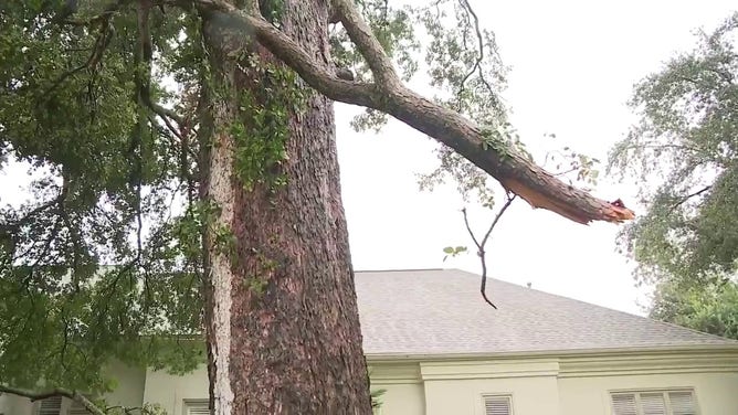
![Trees are seen damaged in San Antonio, Texas after an apparent tornado Oct. 26, 2023.]() Image 10 of 13
Image 10 of 13Trees are seen damaged in San Antonio, Texas after an apparent tornado Oct. 26, 2023. (KABB-TV)
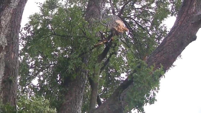
![Trees are seen damaged in San Antonio, Texas after an apparent tornado Oct. 26, 2023.]() Image 11 of 13
Image 11 of 13Trees are seen damaged in San Antonio, Texas after an apparent tornado Oct. 26, 2023. (KABB-TV)
![Trees are seen damaged in San Antonio, Texas after an apparent tornado Oct. 26, 2023.]() Image 12 of 13
Image 12 of 13Trees are seen damaged in San Antonio, Texas after an apparent tornado Oct. 26, 2023. (KABB-TV)
![Trees are seen damaged in San Antonio, Texas after an apparent tornado Oct. 26, 2023.]() Image 13 of 13
Image 13 of 13Trees are seen damaged in San Antonio, Texas after an apparent tornado Oct. 26, 2023. (KABB-TV)


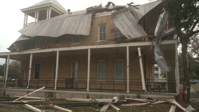
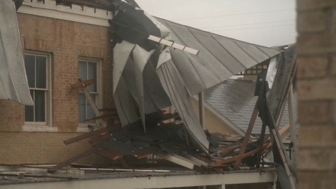
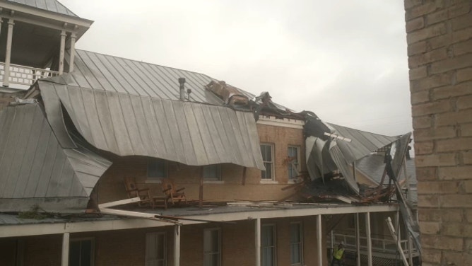
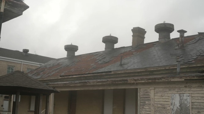


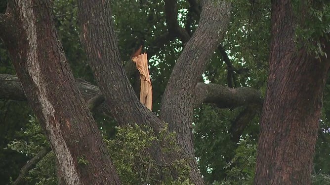
Joint Base San Antonio (JBSA) reported a "brief, very weak tornado" touched down on the military base about 8 a.m. CDT. No injuries were reported, but JBSA-Fort Sam Houston said there were downed trees and some damaged vehicles.

Tornado damage at Ft. Sam Houston. Oct. 26, 2023.
(@8xbrandon / WEATHER TRAKER /TMX / FOX Weather)
An NWS storm survey team later confirmed Friday an EF-0 tornado touched down through Fort Sam Houston Thursday morning, lasting about 17 minutes as it swirled on the ground for just over 5 miles. The twister's peak wind speed was estimated at 80 mph.
HOW LONG DO TORNADOES LAST AND HOW DO THEY FORM?

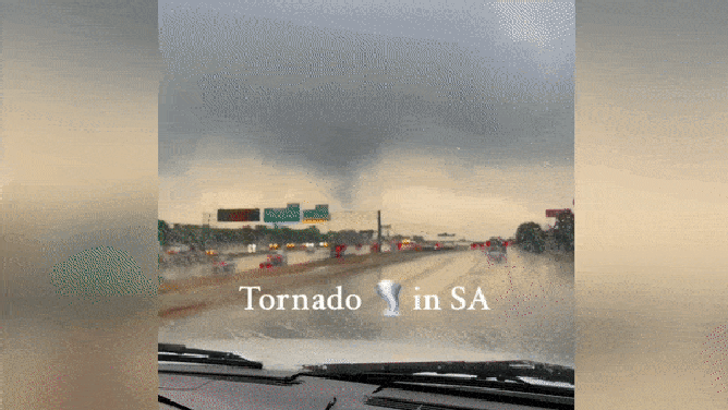
Drivers spot tornado crossing San Antonio highway
In this video shared by KABB-TV, drivers recorded video of an apparent tornado crossing a highway in the San Antonio area on Oct. 26, 2023.
The footage above captured the moment the apparent tornado crossed a highway in the San Antonio area.
"Wow!" a person can be heard saying in the video as they watch the twister approach. As it does, debris kicked up by the wind hits the metal siding and glass windows of their vehicle.
Another video captures more images of the tornado over the highway.
Tornado in San Antonio, Texas. Oct. 26, 2023.
(@visionsforyou210 / TikTok / FOX Weather)
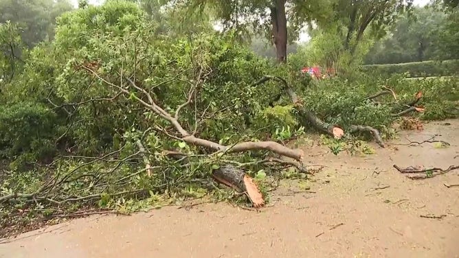
Another video from the tornado's path shows branches are seen snapped on trees and scattered along the ground in the San Antonio area, with tipped-over garbage bins nearby and a sheet of metal hanging on power lines.
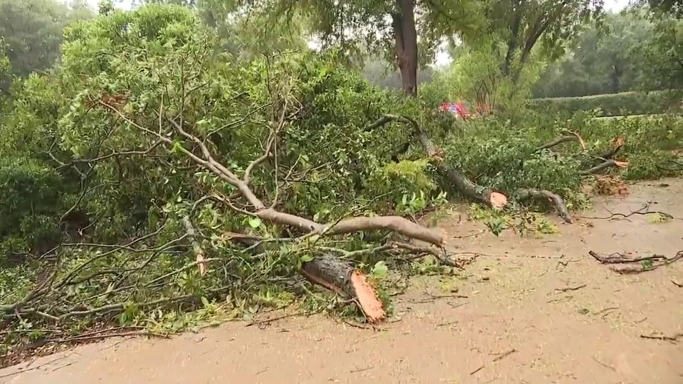
Storm damage seen in San Antonio
Video shared by KABB-TV shows damage after an apparent tornado moved through the San Antonio area on Oct. 26, 2023.
Flooding in Texas
Earlier Thursday morning, heavy rain moved into the Dallas-Fort Worth Metroplex, prompting the NWS to issue Flash Flood Warnings. High-water rescues were reported in Dallas after an estimated 2-4 inches of rain had soaked the area.

Heavy rain leads to flooding, traffic troubles throughout Dallas area
The downpour overnight flooded streets in parts of Tarrant County, Texas, FOX 4 in Dallas reports. While the rain has begun to move out of the Dallas-Fort Worth Metroplex, it was quite heavy early Thursday morning.
In Mansfield, Texas, just south of Dallas-Fort Worth, firefighters said they had to use a hovercraft to rescue several people after the city received more than 5 inches of rain over the past 24 hours.
"Plan your route and avoid areas that are prone to flooding," the Mansfield Fire Department warned on social media. "It doesn’t take much water to float your vehicle. We have responded to two different water rescues."

Texas firefighters use hovercraft to rescue people from flooding
The Mansfield, Texas, Fire Department used a hovercraft to rescue several people Thursday after firefighters said the city received more than 5 inches of rain over the past 24 hours.
Thursday's active weather comes after the Dallas area recorded its wettest day of the year at Dallas-Fort Worth International Airport, receiving 2.54 inches on Wednesday. It was also the wettest day since Nov. 5, 2022, when the city picked up 3.01 inches.
Some areas in North Texas, such as Cherokee and McKinney, have received more than 9 inches of rain in the last 48 hours.
In Central Texas, the Texas State University campus in San Marcos was awash in floodwater after torrential rain poured over the area.

Flooding at Texas State University. Oct. 26, 2023.
(Mara Grace / FOX Weather)
More rain to come
An arctic cold front will arrive over the Southern Plains on Friday and trigger another round of thunderstorms across the region, according to the FOX Forecast Center. As much as 3–5 inches of rain is expected.

(FOX Weather)
Another risk for flash flooding will develop for portions of northeastern Texas, including the Dallas-Fort Worth metro, through the ArkLaTex and into western Arkansas, where 1-2" of rain over relatively moist soils from antecedent rain could lead to flash flooding.
Some isolated spots in the southern Plains could even end up with rainfall totals between 5 and 8 inches when combining all the rain that has fallen throughout the week.
Urban areas, roads and small streams will be the most vulnerable to additional flash flooding through Friday.

(FOX Weather)
This flash flood threat shifts into northern Arkansas and southern Missouri on Saturday as the cold front moves into that area, the FOX Forecast Center said.
Another threat for flash flooding will develop from this region back into eastern Oklahoma.

(FOX Weather)
Much of Texas and Oklahoma have seen precipitation from this week's super-soaker storm, but communities west of Dallas have been getting the bulk of the rainfall – from Del Rio along the Texas-Mexico border northward into Oklahoma City and central Oklahoma.
Farther north in the central U.S., the FOX Forecast Center said a cold front over the upper Great Lakes to the central High Plains will have moisture pooling along the front, producing showers and thunderstorms with heavy rain in that region. This may lead to flash flooding in parts of the upper Mississippi Valley and upper Great Lakes through Friday morning.
Storms to dent, but not eliminate, severe drought
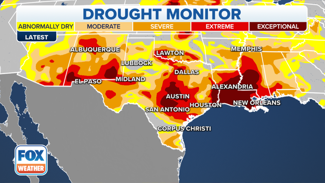
(Here's a look at the current drought monitor. / FOX Weather)
If the storms can keep the flash flooding impacts at bay, the rain is undoubtedly welcome news for communities that have been dealing with drought conditions, water restrictions and even crop failures.
More than 88% of Texas counties are experiencing abnormally dry conditions, with similar figures in Oklahoma. Dallas and Austin about a foot or more below average for rainfall totals for this time of year.
TEXAS BECOMES NATION'S FOCUS FOR INTENSIFYING DROUGHT
But while any rain helps, the precipitation will not be enough to end the drought. Many communities will likely finish the year with rainfall deficits.